KTET Exam  >  KTET Tests  >  Kerala SET Mock Test Series 2024  >  Kerala SET Paper 2 Mock Test - 5 (Geography) - KTET MCQ

Kerala SET Paper 2 Mock Test - 5 (Geography) - KTET MCQ


Test Description

30 Questions MCQ Test Kerala SET Mock Test Series 2024 - Kerala SET Paper 2 Mock Test - 5 (Geography)

Kerala SET Paper 2 Mock Test - 5 (Geography) for KTET 2024 is part of Kerala SET Mock Test Series 2024 preparation. The Kerala SET Paper 2 Mock Test - 5 (Geography) questions and answers have been prepared according to the KTET exam syllabus.The Kerala SET Paper 2 Mock Test - 5 (Geography) MCQs are made for KTET 2024 Exam. Find important definitions, questions, notes, meanings, examples, exercises, MCQs and online tests for Kerala SET Paper 2 Mock Test - 5 (Geography) below.
Solutions of Kerala SET Paper 2 Mock Test - 5 (Geography) questions in English are available as part of our Kerala SET Mock Test Series 2024 for KTET & Kerala SET Paper 2 Mock Test - 5 (Geography) solutions in Hindi for Kerala SET Mock Test Series 2024 course. Download more important topics, notes, lectures and mock test series for KTET Exam by signing up for free. Attempt Kerala SET Paper 2 Mock Test - 5 (Geography) | 120 questions in 120 minutes | Mock test for KTET preparation | Free important questions MCQ to study Kerala SET Mock Test Series 2024 for KTET Exam | Download free PDF with solutions
Kerala SET Paper 2 Mock Test - 5 (Geography) - Question 1

As per the theory of demographic transition, the post-transitional stage of demographic transition is characterised by ______. 

Detailed Solution for Kerala SET Paper 2 Mock Test - 5 (Geography) - Question 1

The correct answer is low and nearly equal birth and death rates.

Key Points 

  • Demographic Transition Theory
    • It predicts the shift in the population (birth and death rate) of an area.
    • This theory also studies the relationship between economic development and population growth.
  • The Demographic Transition Model was developed by the American demographer Warren Thompson in 1929.

Additional Information 

  • There are 5 stages of Demographic Transition :
  • Stage 1: High Population Growth Potential
    • This is a state of high birth and death rates resulting in low population growth overall.
  • Stage 2: Population Explosion
    • With a consistently high birth rate and decreasing death rate, population growth surges.
  • Stage 3: Population Growth reaches a steady rate
    • As the birth rate falls and the death rate remains low, the population continues to increase.
  • Stage 4: Stationary Population
    • Traditionally considered to be the final stage, this is one of demographic stabilization, in which both birth and death rates are low.
    • This means that the overall population stays fairly low.
  • Stage 5Further Changes in Birth Rates

The third stage of demographic transition is characterized by a low and nearly equal birth and death rates

Kerala SET Paper 2 Mock Test - 5 (Geography) - Question 2

Given below are two statements. One is labelled as Assertion (A) and the other is labelled as Reason (R).

Assertion (A): The River Ganga has a deep but narrow channel at Rishikesh.

Reason (R) : Lateral cutting occurs at the youthful stage in rivers.

Select the correct answer from options given below:

Detailed Solution for Kerala SET Paper 2 Mock Test - 5 (Geography) - Question 2

 The River Ganga originates at Gangotri glacier in the Himalayas. It is in its youthful stage in the mountains of Himalayas. A river does downward cutting in its youthful stage while it does lateral cutting in later stages. At Rishikesh, the channel of Ganga is narrow and deep due to downward cutting done by river Ganga.

Thus, the correct answer is C.

1 Crore+ students have signed up on EduRev. Have you? Download the App
Kerala SET Paper 2 Mock Test - 5 (Geography) - Question 3

Globigerina ooze is

Detailed Solution for Kerala SET Paper 2 Mock Test - 5 (Geography) - Question 3

The Correct Answer is Pelagic deposit.​

Key Points

  • This Globigerina ooze is the most densely spread of the oozes which occur both in the Atlantic and in the Indian oceans. While Pteropod ooze is found in the middle of the Atlantic.
  • globigerina ooze a layer of soft mud made up in large part of the shells of dead globigerina and covering great areas of the sea bottom at depths of 1000 to 3000 feet.
  • globigerina ooze formed
    • Globigerina ooze Deep-sea ooze in which at least 30% of the sediment consists of planktonic Foraminiferida, including chiefly Globigerina.
    • It is the most widespread deposit to form from the settling out of material from overlying waters, covering almost 50% of the deep-sea floor.

Kerala SET Paper 2 Mock Test - 5 (Geography) - Question 4
Which of the following statements are true about John Friedmann’s Matter of the Centre Vs. Periphery?

(a) The theory is similar to Growth Pole Theory by Francis Perroux.

(b) Development poles are urban centers with many economic activities which are diversified in nature.

(c) The central town is the supplier of commodities for consumption.

(d) The central district provides raw material to the peripheral towns.

Select the correct answer from the codes given below:

Detailed Solution for Kerala SET Paper 2 Mock Test - 5 (Geography) - Question 4

John Friedmann presented his theory in 1966 about the difference central town and periphery. The theory makes two parts of developing town, as given by Francis Perroux. The theory divides a developing towns/poles into f types: Central cities, growth poles, development poles and integration poles. The development poles are urban districts which have diversified economic activities. The central town or pole is centre of development. The finished product is available here for input into tertiary activities and for consumption. It takes the required raw materials from towns in periphery.

Thus, the correct answer is A.

Kerala SET Paper 2 Mock Test - 5 (Geography) - Question 5

Match List I with List II

Detailed Solution for Kerala SET Paper 2 Mock Test - 5 (Geography) - Question 5
  • Ash or Cinder cones are formed when the volcanic material thrown out of the volcano cools and form small solid pieces known as cinders. The solid particles that are rained down create a circular cone around the crater and a cinder cone is formed. These are also termed as central type of volcanoes. The cones of Krakatoa, Mt. Pele, Mt. Fuji are certain examples.
  • The Acid Lava cone is formed by viscous lava and which has a presence of silica. This lava deposits itself near the neck of the crater just after an explosion and later forms a dome by solidification. Lessen Peak of California and Pary-de-dome of France are perfect examples.
  • Basic lava cone or shield volcanoes are different from the acid lava cones in terms of material compositions and shape formation. The basaltic lava having low silica content flows out quietly and gives rise to the formation of a shield. A shield shaped volcano forms with a wide base and low slope in course of time. Best example is the Mauna Loa od Hawaiian Island.
  • The composite are probably the largest and highest volcanic cones. They are formed by the deposition of lava and ash, layer after layer in a parallel format. Fujiyama, Mayen are the best examples of such cones.
Kerala SET Paper 2 Mock Test - 5 (Geography) - Question 6

Consider the following statements about insolation and choose the correct option.

(A) Insolation is the incoming solar energy intercepted by the earth

(B) The amount and the intensity of the insolation vary during a day, in a second and in a year

(C) The amount of insolation increases from the equator towards the poles

Detailed Solution for Kerala SET Paper 2 Mock Test - 5 (Geography) - Question 6

The correct answer is Only (A) and (B) are true.

Key Points: PointsThe question is about insolation, which is the incoming solar energy the Earth intercepts.

  • Option 1 is the correct answer, as statements (A) and (B) are true.
  • Statement (A) is true as insolation is the incoming solar energy the earth intercepts.
  • Statement (B) is also true as the amount and intensity of insolation vary during a day, in a second, and in a year.
  • These variations are due to factors such as the sun's angle, the atmosphere's thickness, and the earth's rotation and revolution.
  • Option 2 is incorrect as statement (A) is true, but statement (C) is false.
  • The amount of insolation actually decreases from the equator towards the poles.
  • Option 3 is incorrect as statement (B) is true, but statement (C) is false.
  • Option 4 is incorrect as all three statements are true, not false.

Additional Information

  • Insolation is an important factor that affects climate, weather, and ecosystems.
  • The variations in insolation can cause differences in temperature, pressure, wind, and precipitation patterns.
  • The equator receives more insolation than the poles because the sun's rays are more direct and spread over a smaller area.
  • The tilt of the earth's axis also affects the amount and distribution of insolation, leading to the seasons.
Kerala SET Paper 2 Mock Test - 5 (Geography) - Question 7
Read the following statements given below:

(a) Monsoon break is the phenomenon which means monsoon rainfall stops for a couple of days.

(b) Western Ghats receive orographic rain during the  monsoon.

(c) First rain in a place is called as monsoon burst.

(d) The El Nino current decreases the temperature of water.

Select the correct option:

Detailed Solution for Kerala SET Paper 2 Mock Test - 5 (Geography) - Question 7

Western Ghats lie near the western coast of India. They occur as a hindrance for the winds of South-west monsoon winds and lead to orographic rain in the area. First occurrence of rain in an area is called as monsoon burst. During the Monsoon season, there are periods when there are sharp decrease in rainfall over most parts of the country, this is called monsoon break. The El Nino is a warm current and hence it leads to increase in temperatures by 3-4 degree Celsius.

Kerala SET Paper 2 Mock Test - 5 (Geography) - Question 8

Consider the following statements with reference to most of the western countries:

1. Males outnumber females in rural areas.

2. Females outnumber the males in urban areas.

Which of the above statement(s) is/are correct?

Detailed Solution for Kerala SET Paper 2 Mock Test - 5 (Geography) - Question 8

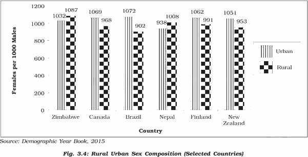
Rural Urban Composition

Source - NCERT

  • The rural and urban differences in sex ratio in Canada and West European countries like Finland are just the opposite of those in African and Asian countries like Zimbabwe and Nepal respectively. 
  • In Western countries, males outnumber females in rural areas and females outnumber the males in urban areas
  • In countries like Nepal, Pakistan and India the case is reversed
  • The excess of females in urban areas of U.S.A., Canada and Europe is the result of influx of females from rural areas to avail of the vast job opportunities. 
  • Farming in these developed countries is also highly mechanised and remains largely a male occupation. 
  • By contrast the sex ratio in Asian urban areas remains male dominated due to the predominance of male migration
  • Also, in countries like India, female participation in farming activity in rural areas is fairly high

Shortage of housing, high cost of living, paucity of job opportunities and lack of security in cities, discourage women from migrating from rural to urban areas.

Kerala SET Paper 2 Mock Test - 5 (Geography) - Question 9
Which of the following factors are required for the cultivation of wheat?
Detailed Solution for Kerala SET Paper 2 Mock Test - 5 (Geography) - Question 9

Wheat is a rabi crop and requires a temperature of 21-26 degree Celsius during the summer season. Annual rainfall of about 75 cm. is perfect for the cultivation of wheat. However, it can be grown in a variety of soils, well drained fertile and clay loams.

Kerala SET Paper 2 Mock Test - 5 (Geography) - Question 10
The concept of ‘Ecological niche’ was introduced by _______.
Detailed Solution for Kerala SET Paper 2 Mock Test - 5 (Geography) - Question 10

Correct Answer: J. Grinnell.

Key Points

  • The ecological niche of a species has been defined by the resources it requires and by its role or function in the environment. The concept of the ecological niche when introduced by Grinnell (1917) focused on the habitat requirements of a species for it to survive and reproduce.
  • The concept of the ecological niche was first introduced by Joseph Grinnell in 1917. focused on the environmental factors that determined where a species could survive rather than interactions between species. Around the same time, an English ecologist named Charles Elton was developing his own ideas about niches. In his definition, a species’ niche was determined by its interactions with other species—namely its relationships with food and predators
  • A plant's or animal's niche, or more correctly, ecological niche, is a way of life that is unique to that species. Niche and habitat are not the same. While many species may share a habit, this is not true for a niche. Each plant and animal species is a member of a community. The niche describes the species' role or function within this community.
  • Almost 40 years later, in the late 1950s, English ecologist G. Evelyn Hutchinson blended these two versions into a broader definition. This definition considers all abiotic and biotic factors that influence a species in a quantifiable way. This definition is still used by scientists today. It is important to keep learning about species’ niches today because it can help us understand how organisms will respond to environmental changes caused by humans.

Additional Information

  • In ecology, a niche is a term with a variety of meanings related to the behavior of a species living under specific environmental conditions. The ecological niche describes how an organism or population responds to the distribution of resources and competitors. The ecological niche concept expresses the relationship of an individual or a population to all aspects of its environment. Studies on the relationship between the human population and environmental resources have employed a niche concept. The ecological niche comprehends all conditions necessary for an organism to exist.
  • In ecology, the term “niche” describes the role an organism plays in a community. A species’ niche encompasses both the physical and environmental conditions it requires (like temperature or terrain) and the interactions it has with other species (like predation or competition).
  • For example, the rare Kirtland’s warbler (Setophaga kirtlandii), a small songbird of North America, has a very limited niche. It nests only among young jack pine trees (Pinus banksiana), which require periodic wildfires for their seeds to germinate. In this environment, one of the species interactions it must contend with is nest parasitism by the brown-headed cowbird (Molothrus ater). Cowbirds lay their eggs in nests built by other bird species and these host birds then incubate and raise the cowbird’s young, often at the expense of their own babies.
Kerala SET Paper 2 Mock Test - 5 (Geography) - Question 11
Which of the following is not an example of spatial data?
Detailed Solution for Kerala SET Paper 2 Mock Test - 5 (Geography) - Question 11

The correct answer is option 3.

Concept:

Spatial data:

Spatial data is any kind of data that refers to a certain geographical region or place, either directly or indirectly. Spatial data, also known as geospatial data or geographic information, can quantitatively represent a physical item in a geographic coordinate system.

Example of spatial data:

A common example of spatial data can be seen in a road map.

A road map is a two-dimensional object that contains points, lines, and polygons that can represent cities, roads, and political boundaries such as states or provinces. A road map is a visualization of geographic information.

The location of cities, roads, and political boundaries that exist on the surface of the Earth is projected onto a two-dimensional display or piece of paper, preserving the relative positions and relative distances of the rendered objects.

Hence the correct answer is times of particular events.

Kerala SET Paper 2 Mock Test - 5 (Geography) - Question 12
A recurring climate pattern involving changes in the temperature of waters in the central and eastern tropical Pacific Ocean is known as:
Detailed Solution for Kerala SET Paper 2 Mock Test - 5 (Geography) - Question 12

The correct answer is ENSO

Key Points

  • The El Niño-Southern Oscillation (ENSO) is a recurring climate pattern involving changes in the temperature of waters in the central and eastern tropical Pacific oceans.
  • The Southern Oscillation is a change in air pressure over the tropical Pacific Ocean.
  • When coastal waters become warmer in the eastern tropical Pacific (El Niño), the atmospheric pressure above the ocean decreases.
  • El Niño and La Niña are the extreme phases of the ENSO cycle; between these two phases is a third phase called ENSO-neutral.
Additional Information
  • ENSO is one of the most important climate phenomena on Earth due to its ability to change the global atmospheric circulation, which in turn, influences temperature and precipitation across the globe.
  • El Niño:
    • A warming of the ocean surface, or above-average sea surface temperatures (SST), in the central and eastern tropical Pacific Ocean.
    • Over Indonesia, rainfall tends to become reduced while rainfall increases over the central and eastern tropical Pacific Ocean.
    • In general, the warmer the ocean temperature anomalies, the stronger the El Niño.
  • La Niña:
    • Cooling of the ocean surface, or below-average sea surface temperatures (SST), in the central and eastern tropical Pacific Ocean.
    • Over Indonesia, rainfall tends to increase while rainfall decreases over the central and eastern tropical Pacific oceans. The normal easterly winds along the equator become even stronger.
    • In general, the cooler the ocean temperature anomalies, the stronger the La Niña (and vice-versa).
  • Neutral:
    • Neither El Niño or La Niña. Often tropical Pacific SSTs are generally close to average.
    • However, there are some instances when the ocean can look like it is in an El Niño or La Niña state, but the atmosphere is not playing along (or vice versa).
Kerala SET Paper 2 Mock Test - 5 (Geography) - Question 13

The currents in which of the following ocean change their flow direction twice a year due to northeast and southwest monsoon winds?

Detailed Solution for Kerala SET Paper 2 Mock Test - 5 (Geography) - Question 13

The Correct Answer is the Northern Indian Ocean.

Key Points

  • The current systems of the Indian Ocean are largely controlled and modified by landmasses and monsoon winds.
  • The currents in the northern Indian Ocean change their flow direction twice a year due to northeast and southwest monsoon winds.
  • monsoon Indian Ocean
    • The summer monsoon is associated with heavy rainfall. It usually happens between April and September.
    • As winter ends, warm, moist air from the southwest Indian Ocean blows toward countries like India, Sri Lanka, Bangladesh, and Myanmar.
    • The summer monsoon brings a humid climate and torrential rainfall to these areas.
  • They are of 2 types warm and cold ocean currents.
  • The cold currents are absent in the northern part of the Indian Ocean. Cold ocean current flows from the polar region to the equator. The Indian Ocean is landlocked in the North.

Additional Information

  • Warm Ocean Currents-
    • KuroshioCurrent
    • Agulhas
    • Gulf Stream
    • Brazilian Current
    • North Atlantic Drift
  • Cold Ocean Currents
    • Benguela
    • Humboldt
    • Labrador
    • Canary
    • California Current
Kerala SET Paper 2 Mock Test - 5 (Geography) - Question 14

Consider the following statements:

1. India's first solar-wind hybrid plant is located in Maharashtra.

2. Diu is the first solar-powered island in India.

3. India's first village to be powered by solar all day is located in Gujarat.

Which of the statements given above are correct?

Detailed Solution for Kerala SET Paper 2 Mock Test - 5 (Geography) - Question 14

The correct answer is 2 and 3.Key PointsSolar Power:

  • India ranks 3rd in the renewable energy country according to Attractiveness Index’ in 2021.
  • It is the 3rd largest energy-consuming country in the world.
  • India stands 4th globally in Renewable Energy Installed Capacity (including Large Hydro).
  • It ranks 4th in Wind Power capacity & 4th in Solar Power capacity (REN21 Renewables 2022 Global Status Report).
  • India's first wind and solar hybrid power generating plant is located in Jaisalmer, Rajasthan. Hence, statement 1 is incorrect.
  • The hybrid power plant unlocks the full potential of renewable energy.
  • It eliminates generation intermittency and provides a more stable alternative to meet rising power demand.
  • The union territory of "Diu" is India's first solar-powered island. Hence, statement 2 is correct.
  • Diu generates a total of 13 MW of electricity from solar power on a daily basis.
  • Modhera in Gujarat state is India's first village to run entirely on solar power. Hence, statement 3 is correct.
  • The solar project not only reduces the villages' energy bills, but it is also becoming a source of revenue.
Kerala SET Paper 2 Mock Test - 5 (Geography) - Question 15
Which of the following is NOT a characteristic of slum?
Detailed Solution for Kerala SET Paper 2 Mock Test - 5 (Geography) - Question 15

The slum is defined as a run-down area of the city characterized by substandard housing and squalor and lacking in tenure security by the UN-Habitat. Slums have high rates of criminal activities, high poverty, lack of infrastructure, lack of basic health care facilities, etc. Population though is generally high in slums; one billion people worldwide live in slums.

Thus, the correct answer is C.

Kerala SET Paper 2 Mock Test - 5 (Geography) - Question 16
Consider the following statements on application areas of remote sensing and choose which amongst them is true:

i. Remote sensing is used in crop acreages estimation

ii. Different methods of remote sensing are used in soil categorization.

iii. Remote sensing is used in lithological discrimination

iv. Various methods of remote sensing are also used in major river valley projects. .

Detailed Solution for Kerala SET Paper 2 Mock Test - 5 (Geography) - Question 16

Remote sensing is used to acquire the data of remotely sensed areas. It is used in the fields like crop acreages estimation, lithological discrimination, coral reef mapping, forest cover mapping, loss of biological diversity, wealth of oceans, oil fields detection, major river valley projects, management of wild rivers, environment impact analysis amongst many others.

Thus, the Correct answer is D.

Kerala SET Paper 2 Mock Test - 5 (Geography) - Question 17
Between 2010 and 2019, India's population grew at an average annual rate of:
Detailed Solution for Kerala SET Paper 2 Mock Test - 5 (Geography) - Question 17

The correct answer is 1.2%.

  • Between 2010 and 2019, India's population grew at an average annual rate of 1.2%.

Key Points

  • The United Nations Population Fund released the State of World Population 2019 report.
  • India’s population grew at an average annual rate of 1.2 per cent between 2010 and 2019 to 1.36 billion.
  • It was more than double the annual growth rate of China.
  • India also recorded an improvement in life expectancy at birth.
    • The life expectancy at birth in 1969 was 47 years and in 2019, it is 69 years.
  •  According to the report, in India, the total fertility rate per woman was 5.6 in 1969, dropping to 3.7 in 1994 and 2.3 in 2019.
  • The UNFPA report highlights that untold millions have enjoyed healthier and more productive lives in the 50 years since the agency was founded.
Kerala SET Paper 2 Mock Test - 5 (Geography) - Question 18

According to the Radioactive Theory of Mountain Building, which of the following is not a factor that contributes to the formation of mountains?

Detailed Solution for Kerala SET Paper 2 Mock Test - 5 (Geography) - Question 18

Answer 4) The movement of tectonic plates

Key Point

Explanation of all the options:

  • (A) The decay of radioactive elements in the Earth's crust:

Radioactive elements in the Earth's crust decay over time, releasing heat. This heat causes the crust to expand, which can lead to the formation of mountains.

  • (B) The release of heat from radioactive decay:

The heat released from radioactive decay can cause the crust to expand, which can lead to the formation of mountains.

  • (C) The expansion of the Earth's crust:

The expansion of the Earth's crust can lead to the formation of mountains. This expansion can be caused by a number of factors, including the decay of radioactive elements and the movement of tectonic plates.

  • (D)The movement of tectonic plates:

The movement of tectonic plates is not a factor that contributes to the formation of mountains according to the Radioactive Theory of Mountain Building. However, the movement of tectonic plates is the main factor that contributes to the formation of mountains according to the Plate Tectonics Theory.

Additional Information

  •  The Radioactive Theory of Mountain Building was proposed by John Joly in 1925.
  • This theory states that the decay of radioactive elements in the Earth's crust releases heat, which causes the crust to expand. This expansion leads to the formation of mountains.
  • According to the Radioactive Theory of Mountain Building, the decay of radioactive elements in the Earth's crust, the release of heat from radioactive decay, and the expansion of the Earth's crust are all factors that can contribute to the formation of mountains.

Hence, the correct option will be 4) The movement of tectonic plates.

Kerala SET Paper 2 Mock Test - 5 (Geography) - Question 19

Consider the following statements: 

A. Relict Mountain are formed by differential erosion because of differing solubility and erodibility of rocks in the region.

B. Converging boundary volcanism produces island arch like the Japanese arc

C. Alps, Andes, Appalachian and Ural are the examples of Block mountains.

D. GK Gilbert gave the Thermal Contraction Theory in 1890.

Which of the following are Incorrect? 

Detailed Solution for Kerala SET Paper 2 Mock Test - 5 (Geography) - Question 19

Answer: 3) Only C and D.

Key Points

  • Statement C is incorrect because Alps, Andes, Appalachian, and Ural are not examples of block mountains. They are examples of fold mountains.
  • Statement D is incorrect because G.K. Gilbert gave the Glacial rebound theory in 1890, not the Thermal Contraction Theory.
  • Thermal Contraction Theory was given by H. Jeffreys in his famous book, The Earth: Its origin history and physical constitution.

Additional Information 

Relict mountains are mountains that have been worn down by erosion over time. They are typically rounded and have gentle slopes.

Converging boundary volcanism occurs when two tectonic plates collide, causing one plate to be forced beneath the other. This process can create island arcs, which are chains of volcanic islands.

Block mountains are formed when large blocks of the Earth's crust are uplifted or tilted by tectonic forces.

Thermal Contraction Theory states that the Earth's crust has contracted as the Earth has cooled, causing mountains to form.

Glacial rebound theory states that the Earth's crust has rebounded after the weight of glaciers has been removed, causing mountains to form.

Kerala SET Paper 2 Mock Test - 5 (Geography) - Question 20

The oldest rocks tend to be found __________.

Detailed Solution for Kerala SET Paper 2 Mock Test - 5 (Geography) - Question 20

Answer: Option 3) In the interior of continents

Key Points

  • The oldest rocks tend to be found In the interior of continents.
  • This is because the interiors of continents are generally more stable and have been less affected by tectonic activity than the margins of continents or the ocean basins.
  • The Earth's crust is divided into two main types: continental crust and oceanic crust. Continental crust is thicker and less dense than oceanic crust. It is also older, with some continental rocks dating back more than 4 billion years.
  • Oceanic crust, on the other hand, is younger, with most of it being less than 200 million years old.
  • The oldest rocks on Earth are found in the interiors of continents because these areas have been relatively stable and have not been subjected to the same amount of tectonic activity as the margins of continents or the ocean basins.
  • The margins of continents and the ocean basins are more likely to experience earthquakes, volcanic eruptions, and other geological events that can destroy or recycle rocks.

Additional Information

  • On the margins of ocean basins:

The margins of ocean basins are more likely to experience tectonic activity, which can destroy or recycle rocks.

  • In the interiors of ocean basins: 

The interiors of ocean basins are vast submarine regions that collectively cover nearly three-quarters of Earth's surface. The interiors of ocean basins are not typically associated with the oldest rocks as there a regular formation of new crust due to the convectional currents rising beneath the earth. 

  • Along the margins of continents:

The margins of continents are more likely to experience tectonic activity, which can destroy or recycle rocks.

Therefore, the correct answer is "In the interiors of continents".

Kerala SET Paper 2 Mock Test - 5 (Geography) - Question 21
Which of the following is NOT an example of rocks?
Detailed Solution for Kerala SET Paper 2 Mock Test - 5 (Geography) - Question 21

The correct answer is Asphalt.

Key Points

  • Asphalt concrete is one of the most common types of pavement surface materials used in the world. It is a porous material made at a very high temperature of about 180°C that consists of a mixture of asphalt binder (bitumen), aggregate particles, and air voids. After some years of usage, the stiffness of asphalt concrete increases, and its relaxation capacity decreases. The binder becomes more brittle, then micro-cracks develop in it and cracking of the interface between aggregates and binder occurs.

Additional Information

  • Granite:
    • Granite is unstratified rock, plutonic igneous rock, silicious rock
    • Granite is hard, the coarse-grained rock of crystalline structure.
    • It is a type of igneous rock (plutonic rock).
  • Schist is a type of Metamorphic rock.
  • Basalt rock is an example of Extrusive igneous rock.
Kerala SET Paper 2 Mock Test - 5 (Geography) - Question 22

Consider the following statements with respect to Settlements:

1. The Clustered Rural Settlement is a compact or closely built-up area of houses.

2. In Semi-Clustered Settlements one or more sections of the village society choose or are forced to live a little away from the main cluster or village.

3. The Urban Settlements are generally compact and larger in size and engaged in a variety of nonagricultural, economic and administrative functions.

Which of the above statements are correct?

Detailed Solution for Kerala SET Paper 2 Mock Test - 5 (Geography) - Question 22

The correct answer is All the aboveKey PointsSettlements:

  • Clustered Rural Settlement:
    • It is a compact or closely built-up area of houses.
    • In this type of village, the general living area is distinct and separated from the surrounding farms, barns and pastures. Hence Statement 1 is correct
  • Semi-Clustered or Fragmented Settlements:
    • It may result from the tendency of clustering in a restricted area of dispersed settlement.
    • More often such a pattern may also result from the segregation or fragmentation of a large compact village.
    • In this case, one or more sections of the village society choose or are forced to live a little away from the main cluster or village. Hence Statement 2 is correct
  • Urban Settlement:
    • Unlike rural settlements, Urban settlements are generally compact and larger in size.
    • They are engaged in a variety of nonagricultural, economic and administrative functions. Hence Statement 3 is correct

Additional Information Dispersed Settlements:

  • Dispersed or isolated settlement pattern in India appears in the form of isolated huts or hamlets of a few huts in remote jungles, or on small hills with farms or pasture on the slopes.
  • Extreme dispersion of settlement is often caused by the extremely fragmented nature of the terrain and land resource base of habitable areas.
  • Many areas of Meghalaya, Uttarakhand, Himachal Pradesh and Kerala have this type of settlement.
Kerala SET Paper 2 Mock Test - 5 (Geography) - Question 23
The ozone layer helps to protect life from which harmful radiation?
Detailed Solution for Kerala SET Paper 2 Mock Test - 5 (Geography) - Question 23

The correct answer is Ultraviolet radiation

Key Points

  • The ozone layer is one of the layers in the earth’s atmosphere inside the stratosphere layer.
  • It absorbs ultraviolet radiation and protects people, animals, plants, and marine life from the sun’s harmful rays.
  • It was discovered by Charles Fabry and Henri Buisson in 1913.
  • It can absorb 98% of the sun’s ultraviolet rays and almost 90% of ozone is located in the stratosphere layer at a distance of 15 to 30 km from the surface of Earth.
  • In 1989, the Montreal protocol came to protect the ozone layer by cutting the substances that deplete the ozone layer.

Additional Information

  • Ozone, or trioxygen, is an inorganic molecule with the chemical formula O ₃.
  • It is a pale blue gas with a distinctively pungent smell. It is an allotrope of oxygen that is much less stable than the diatomic allotrope O ₂, breaking down in the lower atmosphere to O ₂.
  • Ozone is a particularly effective absorber of UV radiation.
  • The ozone layer in the stratosphere absorbs a portion of the radiation from the sun, preventing it from reaching the planet's surface. Most importantly, it absorbs the portion of UV light called UVB.
  • UVB is a kind of ultraviolet light from the sun (and sun lamps) that has several harmful effects.
Kerala SET Paper 2 Mock Test - 5 (Geography) - Question 24
Who among the following is the first geographer to introduce general systems theory in geography?
Detailed Solution for Kerala SET Paper 2 Mock Test - 5 (Geography) - Question 24

Correct Answer: Richard J. Chorley.

Key Points

  • The concept of general system theory was developed by biologists in the 1920s.
  • It was Ludwig von Bertalanffy who declared that unless we studied an individual organism as a system of multifarious associated parts we would not really understand the laws which govern the life of that organism.
  • After some time he realized that this idea could be applied to other non-biological systems and that these systems had many common characteristics over a range of sciences.
  • It was possible to develop a general system theory that gave the same analytical framework and procedure to all sciences.
  • Richard John Chorley (4 September 1927 – 12 May 2002) was an English geographer, and Professor of Geography at Cambridge University, known as a leading figure in quantitative geography in the late 20th century, who played an instrumental role in bringing in the use of systems theory to geography.
  • It was because of this advantage that Berry and Chorley suggested system analysis and general system theory as the basic tools for geographic understanding. In the opinion of Chorley (1962), there is great significance in system analysis in geographical studies.
  • The general system theory can be understood in the light of a new concept of mathematics and physics.
  • This concept is known as ‘cybernetics’ (from the Greek kybernete—helsman).
  • Cybernetics may be defined as the study of regulating and self-regulating mechanisms in nature and technology.

Additional Information

  • The general system theory provides a framework for relating individual systems and types of systems within a unified hierarchical structure.
  • Such a structure is useful in that it allows us to understand better the relationships that exist between various types of systems; to state categorically the conditions under which one system approximates another, and to identify types of systems that may be useful to us even though we have not yet identified real systems to match them.
Kerala SET Paper 2 Mock Test - 5 (Geography) - Question 25
Which of the following methods may be used to input paper maps into a GIS?
Detailed Solution for Kerala SET Paper 2 Mock Test - 5 (Geography) - Question 25

The correct option is (3)

Concept:-

Scanning, Manual digitizing and Automatic digitizing are the methods may be used to input paper maps into a GIS.

Key Points

  • Paper maps are static depictions of land features as they existed at the time they were made.
  • A digitising tablet, which is a manual pointing device that creates an equivalent vector map on the computer screen, specifying the vertices, points, line data, and so on, is used to manually digitise directly over the raster.
  • GIS was created as an enhancement to the usage and analysis of traditional paper maps.
  • A geographic information system (GIS) is a computer programme that captures, stores, checks, and displays data about locations on the Earth's surface.
  • In a GIS, digitising is the process of converting coordinates from a map, photograph, or other source of data into a digital format.
  • Scanning is the process of converting paper maps into a digital format that can be read by a computer. It's used to turn an analogue map into a scanned file, which is then traced into vector format.
Kerala SET Paper 2 Mock Test - 5 (Geography) - Question 26
Which of the following is NOT typically considered a driver of medical tourism?
Detailed Solution for Kerala SET Paper 2 Mock Test - 5 (Geography) - Question 26

Answer: 4) High-quality healthcare standards in the home country.

Medical tourism refers to the phenomenon of people traveling across international borders to access medical treatments. Several factors drive this trend, ranging from cost considerations to the availability of specialized treatments. Understanding the motivations behind medical tourism is crucial for countries and healthcare providers looking to attract medical tourists

Key Points

4. High-quality healthcare standards in the home country:

  • This option is not typically considered a driver of medical tourism.
  • In fact, high-quality healthcare standards in one's home country would likely reduce the individual's need or desire to seek medical treatment abroad.
  • People generally engage in medical tourism to access treatments that are either unavailable, cost-prohibitive, or of perceived higher quality than those in their home country, not because they already have access to satisfactory healthcare services.
Additional Information
1. Lower cost of medical procedures in foreign countries:
  • One of the primary drivers of medical tourism is the significant cost savings that can be achieved by undergoing medical procedures in countries where they are offered at a lower price.
  • High costs of healthcare in one's home country can motivate individuals to seek more affordable options abroad without compromising the quality of care.
2. Desire for specialized treatments unavailable in home country:
  • Another key motivation for medical tourism is the pursuit of specialized treatments that may not be available in the individual's home country.
  • This includes cutting-edge medical procedures, experimental treatments, and access to specialists with unique expertise in certain medical conditions.
3. Cultural attractions and tourism opportunities offered by destination:
  • While not the primary driver, the opportunity to combine medical treatment with vacation-like activities in the destination country can be an appealing factor for some medical tourists.
  • This aspect of medical tourism allows individuals to enjoy the cultural and tourism offerings of the destination while receiving medical care.
Important Points
  • As medical tourism continues to grow, it's important for destination countries and providers to understand the diverse factors motivating patients to travel for healthcare.
  • Ensuring high standards of care, transparent communication, and supportive services can enhance their attractiveness to potential medical tourists.
  • Moreover, addressing potential ethical and regulatory issues associated with medical tourism is vital for creating a sustainable and responsible medical tourism industry.
Kerala SET Paper 2 Mock Test - 5 (Geography) - Question 27
What BEST describes the impact of technology on the tourism industry?
Detailed Solution for Kerala SET Paper 2 Mock Test - 5 (Geography) - Question 27

Answer: 3) It offers both opportunities for personalized experiences and privacy concerns.

The profound impact of technology on the tourism industry cannot be overstated. It has revolutionized how services are delivered, enhanced the customer experience, and also introduced new challenges. Among these impacts, the ability to offer personalized travel experiences alongside emerging privacy concerns stands out as especially significant.
Key Points
It offers both opportunities for personalized experiences and privacy concerns:
  • Advanced data analytics and AI enable travel companies to tailor their offerings to individual preferences, improving customer satisfaction and engagement.
  • From personalized travel recommendations to targeted marketing, technology makes it possible to cater to the unique desires of each traveler.
  • However, this customization relies on collecting and analyzing vast amounts of personal data, raising legitimate concerns about privacy and data protection.
  • As companies navigate these opportunities, they must also address the ethical considerations and regulatory requirements associated with handling personal information.
Additional Information
INCOREECT OPTIONS:
It primarily leads to job losses in the travel industry:
  • While technology has automated certain functions that previously required manual effort, suggesting that it primarily leads to job losses oversimplifies its impact.
  • Technology also creates new opportunities and jobs within the industry, such as in digital marketing, data analysis, and IT support.
  • Furthermore, by improving efficiency and customer experiences, technology can drive growth and demand, potentially leading to job creation in other areas of the tourism sector.
It solely benefits large travel companies and booking platforms:
  • Although large travel companies and booking platforms have indeed benefited from technological advancements, they are not the sole beneficiaries.
  • Technology has also empowered smaller operators by leveling the playing field, enabling them to reach a global audience through social media, online marketplaces, and affordable travel technologies.
  • Startups and innovative enterprises can disrupt the market with new ideas and services, indicating that the benefits of technology in tourism are more widely distributed.
It has minimal impact on travel planning and booking processes:
  • This statement underestimates the dramatic transformation technology has brought to planning and booking travel.
  • Online booking platforms, mobile apps, virtual reality previews, and user-generated content on social media have all made researching and booking travel more accessible, convenient, and informative for consumers.
  • The shift towards online and mobile channels has fundamentally changed how travelers interact with the industry, making technology's impact far from minimal.
Important Points
  • The intersection of technology and tourism continues to evolve, offering immense potential to enhance the travel experience while posing new challenges.
  • As the industry adapts to these changes, the focus should remain on harnessing technology to improve services and operational efficiency, while also prioritizing ethical considerations and customer trust, particularly concerning privacy.
Kerala SET Paper 2 Mock Test - 5 (Geography) - Question 28

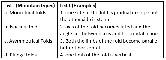
Match List I with List II

Detailed Solution for Kerala SET Paper 2 Mock Test - 5 (Geography) - Question 28
  • Monoclinal Folds are referred to those where the compressional forces act in such a way that one limb of the fold is totally vertical.
  • Isoclinal folds, also known as Overfolds are formed when the compressional forces are so strong that both the sides of the fold are inclined in the same direction. The short and steep side also dips in the same direction as the flat or gradual sloping side but the sides of the fold are not horizontal
  • Asymmetrical folds are formed when one limb of the fold is pushed too far so that one side of the fold is long and gradual in slope while the other is short and steep. This shows a unilateral element.
  • Plunge folds are found when the axis of the fold, instead of being parallel to the horizontal plane becomes tilted and forms plunge angle, which is the angle between the axis and the horizontal plane.
Kerala SET Paper 2 Mock Test - 5 (Geography) - Question 29
Match List-I with List-II:

Codes

Detailed Solution for Kerala SET Paper 2 Mock Test - 5 (Geography) - Question 29

Absorption is defined as the process in which the incident energy is retained by a substance and is irreversibly converted into some other form of energy. Gases are selective absorbers. There is a certain amount of energy loss by the process of absorption in the atmosphere. Nitrogen is a poor absorber of incoming while oxygen and ozone are considered as good absorbers of solar radiation.

When the diameter of the particles is larger than the wavelength of the incident beam of light, true scattering does not occur and the effect of the particles is the nature of diffuse reflection or diffusion. As the process of diffusion s non-selective, component colours of the incident light do not get separated. This is the reason why the sun behind the observer is pure white. Also, the diffused light during twilight is due to this phenomenon.

Reflection refers to the part of the incident light which, falling on any surface is reflected. Thus, a certain amount of energy is lost and does not play a role in the heating of the atmosphere. The reflectivity of a substance is known as the albedo.

The atmosphere is composed of molecules of air, water molecules, and dust particles. These molecules scatter the shorter ultraviolet waves in different directions. This process, in meteorological terms, is known as scattering.

Kerala SET Paper 2 Mock Test - 5 (Geography) - Question 30
“When a particular area starts developing, it attracts human as well as physical capital” these phenomena is called?
Detailed Solution for Kerala SET Paper 2 Mock Test - 5 (Geography) - Question 30

Swedish economist Gunnar Myrdals propagated an economic development effect model namely backwash effect. Backwash effect basically means that if one particular area in a country starts growing or developing, it causes human capital as well as physical capital from other parts of the country to gravitate to this part of the country.

View more questions
30 tests
Information about Kerala SET Paper 2 Mock Test - 5 (Geography) Page
In this test you can find the Exam questions for Kerala SET Paper 2 Mock Test - 5 (Geography) solved & explained in the simplest way possible. Besides giving Questions and answers for Kerala SET Paper 2 Mock Test - 5 (Geography), EduRev gives you an ample number of Online tests for practice

Top Courses for KTET

Download as PDF

Top Courses for KTET