PFRDA Assistant Manager Phase 1 Mock Test - 6 (Paper 1) - Insurance Exams MCQ
30 Questions MCQ Test - PFRDA Assistant Manager Phase 1 Mock Test - 6 (Paper 1)

Directions: Read the following passage carefully and answer the questions given beside.
Remote sensing and GIS are promising tools for handling spatial and temporal data and help in integrating them for successful planning of natural resources. It is the science of measuring the earth using sensors mounted on high-flying aircrafts or satellites. These sensors collect data in the form of images and provide insights for manipulating, analysing and visualising those images. Since natural resources are not uniformly distributed and are spatially varied, it is challenging to capture the correct picture. Management of natural resources calls for scientific tools for timely and accurate dissemination of information. In natural resource management, remote sensing and GIS are mainly used in the mapping process. These techniques are useful in management of land, soil, coastal, watershed, urban and many more.
In India, the agriculture sector alone sustains the livelihood of around 50 percent of the population. Therefore, an increase in crop productivity has been a major concern. Since, the scope for increasing area under agriculture is limited, advanced crop production forecasting is required for better policymaking. Indian Space Research Agency (ISRO) and Indian Council of Agricultural Research (ICAR) successful experiment-Agricultural Resource Inventory and Survey Experiment (ARISE) used aerial colour photographs to estimate crop acreage in many states of India. Other Important uses of remote sensing include crop identification, stress detection, and crop yield modelling, drought monitoring, land degradation mapping and more. Urbanisation is important and inevitable for development, but its proper planning and management is crucial for sustenance. One of the important features of GIS is multilayered mapping. This kind of mapping helps municipal corporations, town planning boards to build cities that are better organised. The information systems with socio-economic data overlaid upon satellite data makes urban planning cost-effective and accurate.
Coastal ecosystems have high ecological significance. GIS and remote sensing data are used to study coastal ecosystems and marine living resources which include habitats like mangroves, coral reefs and more. Apart from this, suspended shoreline dynamics can be studied and climatic changes leading to cyclones and sea level rise may be of special interest too. Geospatial data is effective in the analysis and determination of factors that affect the utilisation of these resources. The technologies provide a platform through which we can generate information that can be used to make sound decisions for sustainable development of the natural resources of India.
Q. How effective are remote sensing and GIS in managing urban growth?
I. GIS and remote sensing are helpful in building cities that are better organized.
II. The system makes urban planning cost-effective and accurate.
III. They help the government disseminate people living in extremely densed areas to less populated ones.
II. The system makes urban planning cost-effective and accurate.
III. They help the government disseminate people living in extremely densed areas to less populated ones.
Directions: Read the following passage carefully and answer the questions given beside.
Remote sensing and GIS are promising tools for handling spatial and temporal data and help in integrating them for successful planning of natural resources. It is the science of measuring the earth using sensors mounted on high-flying aircrafts or satellites. These sensors collect data in the form of images and provide insights for manipulating, analysing and visualising those images. Since natural resources are not uniformly distributed and are spatially varied, it is challenging to capture the correct picture. Management of natural resources calls for scientific tools for timely and accurate dissemination of information. In natural resource management, remote sensing and GIS are mainly used in the mapping process. These techniques are useful in management of land, soil, coastal, watershed, urban and many more.
In India, the agriculture sector alone sustains the livelihood of around 50 percent of the population. Therefore, an increase in crop productivity has been a major concern. Since, the scope for increasing area under agriculture is limited, advanced crop production forecasting is required for better policymaking. Indian Space Research Agency (ISRO) and Indian Council of Agricultural Research (ICAR) successful experiment-Agricultural Resource Inventory and Survey Experiment (ARISE) used aerial colour photographs to estimate crop acreage in many states of India. Other Important uses of remote sensing include crop identification, stress detection, and crop yield modelling, drought monitoring, land degradation mapping and more. Urbanisation is important and inevitable for development, but its proper planning and management is crucial for sustenance. One of the important features of GIS is multilayered mapping. This kind of mapping helps municipal corporations, town planning boards to build cities that are better organised. The information systems with socio-economic data overlaid upon satellite data makes urban planning cost-effective and accurate.
Coastal ecosystems have high ecological significance. GIS and remote sensing data are used to study coastal ecosystems and marine living resources which include habitats like mangroves, coral reefs and more. Apart from this, suspended shoreline dynamics can be studied and climatic changes leading to cyclones and sea level rise may be of special interest too. Geospatial data is effective in the analysis and determination of factors that affect the utilisation of these resources. The technologies provide a platform through which we can generate information that can be used to make sound decisions for sustainable development of the natural resources of India.
Q. In the given context of the passage, why are GIS and remote sensing tools crucial in the agriculture sector?
I. This sector alone sustains the livelihood of around 50 percent of the population.
II. GIS and remote sensing would help in advanced crop production forecasting.
III. Drought monitoring can be done using GIS and remote sensing tools.
II. GIS and remote sensing would help in advanced crop production forecasting.
III. Drought monitoring can be done using GIS and remote sensing tools.

Directions: Read the following passage carefully and answer the questions given beside.
Remote sensing and GIS are promising tools for handling spatial and temporal data and help in integrating them for successful planning of natural resources. It is the science of measuring the earth using sensors mounted on high-flying aircrafts or satellites. These sensors collect data in the form of images and provide insights for manipulating, analysing and visualising those images. Since natural resources are not uniformly distributed and are spatially varied, it is challenging to capture the correct picture. Management of natural resources calls for scientific tools for timely and accurate dissemination of information. In natural resource management, remote sensing and GIS are mainly used in the mapping process. These techniques are useful in management of land, soil, coastal, watershed, urban and many more.
In India, the agriculture sector alone sustains the livelihood of around 50 percent of the population. Therefore, an increase in crop productivity has been a major concern. Since, the scope for increasing area under agriculture is limited, advanced crop production forecasting is required for better policymaking. Indian Space Research Agency (ISRO) and Indian Council of Agricultural Research (ICAR) successful experiment-Agricultural Resource Inventory and Survey Experiment (ARISE) used aerial colour photographs to estimate crop acreage in many states of India. Other Important uses of remote sensing include crop identification, stress detection, and crop yield modelling, drought monitoring, land degradation mapping and more. Urbanisation is important and inevitable for development, but its proper planning and management is crucial for sustenance. One of the important features of GIS is multilayered mapping. This kind of mapping helps municipal corporations, town planning boards to build cities that are better organised. The information systems with socio-economic data overlaid upon satellite data makes urban planning cost-effective and accurate.
Coastal ecosystems have high ecological significance. GIS and remote sensing data are used to study coastal ecosystems and marine living resources which include habitats like mangroves, coral reefs and more. Apart from this, suspended shoreline dynamics can be studied and climatic changes leading to cyclones and sea level rise may be of special interest too. Geospatial data is effective in the analysis and determination of factors that affect the utilisation of these resources. The technologies provide a platform through which we can generate information that can be used to make sound decisions for sustainable development of the natural resources of India.
Q. Why, according to the passage, are GIS and remote sensing considered as promising tools?
I. They collect data in the form of graphs.
II. They provide scope for manipulating, analyzing and visualizing the images.
III. They disseminate data’s more accurately.
II. They provide scope for manipulating, analyzing and visualizing the images.
III. They disseminate data’s more accurately.
Directions: Read the following passage carefully and answer the questions given beside.
Remote sensing and GIS are promising tools for handling spatial and temporal data and help in integrating them for successful planning of natural resources. It is the science of measuring the earth using sensors mounted on high-flying aircrafts or satellites. These sensors collect data in the form of images and provide insights for manipulating, analysing and visualising those images. Since natural resources are not uniformly distributed and are spatially varied, it is challenging to capture the correct picture. Management of natural resources calls for scientific tools for timely and accurate dissemination of information. In natural resource management, remote sensing and GIS are mainly used in the mapping process. These techniques are useful in management of land, soil, coastal, watershed, urban and many more.
In India, the agriculture sector alone sustains the livelihood of around 50 percent of the population. Therefore, an increase in crop productivity has been a major concern. Since, the scope for increasing area under agriculture is limited, advanced crop production forecasting is required for better policymaking. Indian Space Research Agency (ISRO) and Indian Council of Agricultural Research (ICAR) successful experiment-Agricultural Resource Inventory and Survey Experiment (ARISE) used aerial colour photographs to estimate crop acreage in many states of India. Other Important uses of remote sensing include crop identification, stress detection, and crop yield modelling, drought monitoring, land degradation mapping and more. Urbanisation is important and inevitable for development, but its proper planning and management is crucial for sustenance. One of the important features of GIS is multilayered mapping. This kind of mapping helps municipal corporations, town planning boards to build cities that are better organised. The information systems with socio-economic data overlaid upon satellite data makes urban planning cost-effective and accurate.
Coastal ecosystems have high ecological significance. GIS and remote sensing data are used to study coastal ecosystems and marine living resources which include habitats like mangroves, coral reefs and more. Apart from this, suspended shoreline dynamics can be studied and climatic changes leading to cyclones and sea level rise may be of special interest too. Geospatial data is effective in the analysis and determination of factors that affect the utilisation of these resources. The technologies provide a platform through which we can generate information that can be used to make sound decisions for sustainable development of the natural resources of India.
Q. What is the tone of the author?
Directions: Read the following passage carefully and answer the questions given beside.
Remote sensing and GIS are promising tools for handling spatial and temporal data and help in integrating them for successful planning of natural resources. It is the science of measuring the earth using sensors mounted on high-flying aircrafts or satellites. These sensors collect data in the form of images and provide insights for manipulating, analysing and visualising those images. Since natural resources are not uniformly distributed and are spatially varied, it is challenging to capture the correct picture. Management of natural resources calls for scientific tools for timely and accurate dissemination of information. In natural resource management, remote sensing and GIS are mainly used in the mapping process. These techniques are useful in management of land, soil, coastal, watershed, urban and many more.
In India, the agriculture sector alone sustains the livelihood of around 50 percent of the population. Therefore, an increase in crop productivity has been a major concern. Since, the scope for increasing area under agriculture is limited, advanced crop production forecasting is required for better policymaking. Indian Space Research Agency (ISRO) and Indian Council of Agricultural Research (ICAR) successful experiment-Agricultural Resource Inventory and Survey Experiment (ARISE) used aerial colour photographs to estimate crop acreage in many states of India. Other Important uses of remote sensing include crop identification, stress detection, and crop yield modelling, drought monitoring, land degradation mapping and more. Urbanisation is important and inevitable for development, but its proper planning and management is crucial for sustenance. One of the important features of GIS is multilayered mapping. This kind of mapping helps municipal corporations, town planning boards to build cities that are better organised. The information systems with socio-economic data overlaid upon satellite data makes urban planning cost-effective and accurate.
Coastal ecosystems have high ecological significance. GIS and remote sensing data are used to study coastal ecosystems and marine living resources which include habitats like mangroves, coral reefs and more. Apart from this, suspended shoreline dynamics can be studied and climatic changes leading to cyclones and sea level rise may be of special interest too. Geospatial data is effective in the analysis and determination of factors that affect the utilisation of these resources. The technologies provide a platform through which we can generate information that can be used to make sound decisions for sustainable development of the natural resources of India.
Q. What can be the most appropriate title for the passage?
Directions: In the following questions, a sentence is given with two blanks. You have to find the pair of words from the given options that fit both the blanks in the given order and make the sentence grammatically and contextually correct.
The ________ for farm loan waivers has been growing, but this measure alone cannot be a ________ solution to mounting agrarian distress.
Directions: In the question given below there are two statements, each statement consists of two blanks. You have to choose the option which provides the correct set of words that fits both the blanks in both the statements appropriately and in the same order making them meaningful and grammatically correct.
I. The government has ________ over Rs 35,000 crore in cess for the welfare of construction workers employed in the high-risk and hazardous construction industry that is mostly ________ by private companies.
II. Chinese mobile phone maker Huawei said it never ________ or stored Facebook user data, after the social media giant acknowledged it gave access of data to such handset manufacturers albeit in a ________ way.
Direction: In each of the questions given below, a paragraph is given which has some blanks and those blanks have to be filled with the same word out of five words given below it. You have to choose that same word as your answer and fill up the blanks with that appropriate word.
His concern for the affected children is so ____________ that it can be understood without giving much thought. It is not his fault though because all his family members are ____________ in all their dealings and they do not care much about anything in life. It is because of this ____________ nature of his family that they have not got many friends in the neighbourhood.
Instruction for the Next five Questions are given below:
Let children learn to judge their own work. A child ...(1)... to talk does not learn ...(2)... being corrected all the time ...(3)... corrected too much, he will ...(4)... talking. He notices a thousand times a day the difference between the ...(5)... he uses and the language those around him use.
What will come in option one?
Let children learn to judge their own work. A child ...(1)... to talk does not learn ...(2)... being corrected all the time ...(3)... corrected too much, he will ...(4)... talking. He notices a thousand times a day the difference between the ...(5)... he uses and the language those around him use.
What will come in Option Two?
Let children learn to judge their own work. A child ...(1)... to talk does not learn ...(2)... being corrected all the time ...(3)... corrected too much, he will ...(4)... talking. He notices a thousand times a day the difference between the ...(5)... he uses and the language those around him use.
What will come in Option Three?
Let children learn to judge their own work. A child ...(1)... to talk does not learn ...(2)... being corrected all the time ...(3)... corrected too much, he will ...(4)... talking. He notices a thousand times a day the difference between the ...(5)... he uses and the language those around him use.
What will come in Option Four?
Let children learn to judge their own work. A child ...(1)... to talk does not learn ...(2)... being corrected all the time ...(3)... corrected too much, he will ...(4)... talking. He notices a thousand times a day the difference between the ...(5)... he uses and the language those around him use.
What will come in Option Five?
Directions: Given below are four jumbled phrases of a sentence. Out of the given options, pick the one that gives their correct order.
A. The plan's
B. Vigorously the UN will
C. Back it up with action
D. Success depends on how
Directions: In the following question, a sentence is given divided into four parts (A), (B), (C) and (D) which are jumbled up in any random order. You have to arrange the four parts to make a contextually and grammatically meaningful sentence.
typically, when we eat, our bodies (A) / break down the carbohydrates from the food and (B) / turn them into a form of sugar known as glucose, (C) / one of the body’s preferred fuels (D)
Directions: Rearrange the following five sentences A, B, C, D and E in the proper sequence to form a meaningful paragraph and then answer the question given beside.
A. It appears that one of the lessons New Delhi learnt from the standoff with China along the Line of Actual Control in 2020 was that it was perhaps a consequence of India’s growing proximity to the U.S.
B. New Delhi has had a complicated relationship with Washington which is increasingly getting normalised and interests-driven.
C. Or, should India continue the strategic partnership with the U.S. irrespective of what China thinks about it?
D. Despite its withdrawal from the region, Washington is seeking to re-engage southern Asia (Pakistan, South Asia in general, the Indo-Pacific, and perhaps even the Taliban).
E. If so, should New Delhi temper its relations with the U.S., particularly in the Indo-Pacific, in the hope that this will keep Beijing’s aggression at bay?
Which of the following will be the FOURTH statement after the rearrangement of sentences?
Directions: In each of the questions below, a sentence has been broken into four parts with one word highlighted in underline in each fragment. From the given options, identify the word which expresses a meaning opposite to the given sentence, with the highlighted word replaced by a word of the opposite meaning.
Vistara world will introduce (A)/ a live moving map (B)/ display that allows (C)/ passengers to track their aircraft.(D)
Directions: In the given question, a word has been mentioned and there are three ways in which the word has been used in either similar or different ways. You are required to check which of the sentences have correctly used the highlighted word, and mark that as your answer.
Square
I. Mr. Batra wanted to make sure we were square with the court's decision and not subject to a lawsuit.
II. After the party, Mohan and Meera decided to square up the bill.
III. We had been as square with the Startup as any Venture Capitalist could be.
Find out whether there is any grammatical error in below sentence.
Little water / that was left / in the bottle was not enough / to quench the thirst of two persons.
Find out whether there is any grammatical error in below sentence.
The father / as well as the sons were / mysteriously missing / from the house.
Find out the wrong number in the following series?
17 56 175 534 1621 4852 14571
Derive the relationship between x and y by solving the given equations:
6x2 - 51x + 99 = 0
5y2 + 17y + 14 = 0
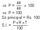
Read the following information carefully and answer the questions based on it.
The following Bar graph shows the number of Educators, Politicians and Doctors in five different areas of Delhi

Find M/N x 100, where
M = sum of doctors in Adarsh Nagar and Ballimaran
N = Sum of Politicians in Ballimaran and Chattarpur

Read the following information carefully and answer the questions based on it.
The following Bar graph shows the number of Educators, Politicians and Doctors in five different areas of Delhi

If the number of politicians in Defence colony is 20% more than the number of politicians in Emanuel market and the number of educators in Defence colony is 41/54 times of the number of Doctors in Dilshad colony and the total persons in all given profession in Defence colony is 20% less than the total persons in all professions in Chattarpur, then find the number of doctors in defence colony?
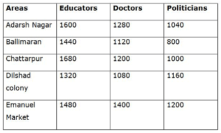
Read the following information carefully and answer the questions based on it.
The following Bar graph shows the number of Educators, Politicians and Doctors in five different areas of Delhi

Find the difference between the average number of Educators in given areas together and the average number of doctors in given areas together?

Read the following information carefully and answer the questions based on it.
The following Bar graph shows the number of Educators, Politicians and Doctors in five different areas of Delhi
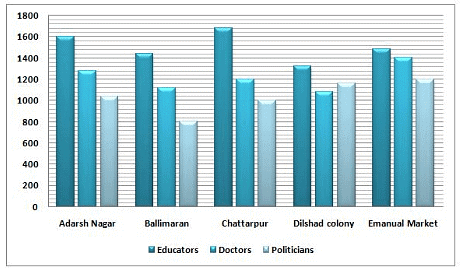
Total number of persons in all profession in Dilshad colony is approximately how much % more or less than the total number of persons in all professions in Emanuel Market?
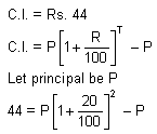
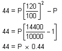
If the compound interest on a certain sum for two years at 20% p.a. is Rs. 44, then what will be the simple interest on the same sum at the same rate for 2 years?

There are two groups in a class of 50 students. Group A consists of 10 members and Group B consists of 20 members. The average marks scored by Group A are 25, and those by Group B are 35. If the average marks of the entire class were 23, then find the average marks of the rest of the class excluding these two groups.
An amount of Rs. 143 was collected from boys and girls in a class of strength 100. If each boy contributed Rs. 1.50, and each girl contributed Rs. 1.40, then find out the number of boys and number of girls in the class.
A man sells two almirahs for Rs. 4500 each. On one, he gains 12.5% and on the other, he loses 10%. Find the overall percentage gain or loss in the whole transaction.
Important Questions for PFRDA Assistant Manager Phase 1 Mock Test - 6 (Paper 1)
PFRDA Assistant Manager Phase 1 Mock Test - 6 (Paper 1) MCQs with Answers
Online Tests for PFRDA Assistant Manager Phase 1 Mock Test - 6 (Paper 1)
|
© EduRev
|
Education Revolution
|


|


