CBSE Sample Question Paper (2022-23) - 5 | Geography Class 11 - Humanities/Arts PDF Download
Time Allowed: 2 hours
Maximum Marks: 80
General Instructions:
- All questions are compulsory.
- Question number 1 to 14 are Multiple choice questions carrying 1 mark each.
- Question number 15 to 16 are Multiple source-based questions carrying 3 marks each.
- Question number 17 to 21 are Short-answer questions carrying 3 marks each. Answer to each of these questions should not exceed 80-100 words.
- Question number 22 to 26 are Long-answer questions carrying 5 marks each. Answer to each of these questions should not exceed 150 words.
- Question number 27 and 28 are related to the identification or locating and labeling of geographical features on maps, carrying 5 marks each.
Q1. _______ geography studies the spatial pattern of natural vegetation in their habitats. [1]
(a) Human
(b) Plant
(c) Zoo
(d) Environmental
Ans: (b) Plant
Q2. The only natural satellite of the earth is: [1]
(a) moon
(b) sun
(c) planets
(d) galaxy
Ans: (a) moon
Q3. The thickness of the continental crust is: [1]
(a) 10 km
(b) 20 km
(c) 30 km
(d) 40 km
Ans: (c) 30 km
Q4. The ocean crust rocks are much younger than the: [1]
(a) continental rocks
(b) continental bay
(c) continental shore
(d) continental sediments
Ans: (a) continental rocks
Q5. _______ contains calcium, aluminum, magnesium, iron, and silica. [1]
(a) Pyroxene
(b) Coal
(c) Sodium
(d) Graphite
Ans: (a) Pyroxene
Q6. The earth’s surface is being continuously subjected to external forces induced basically by. [1]
(a) sunlight
(b) wind
(c) water
(d) power
Ans: (a) sunlight
Q7. _______ can cause significant damage to even un-weathered rocks and can reduce high mountains into low hills and plains. [1]
(a) Cirques
(b) Glacier
(c) Fjords
(d) Drumlins
Ans: (b) Glacier
Q8. _______ is essential to the survival of all organisms. [1]
(a) House
(b) Clothes
(c) Air
(d) Ozone
Ans: (c) Air
Q9. Which one of the following gases is transparent to incoming solar radiation and opaque to outgoing terrestrial radiation: [1]
(a) Oxygen
(b) Nitrogen
(c) Helium
(d) Carbon dioxide
Ans: (d) Carbon dioxide
Q10. The wind circulation around a low is called: [1]
(a) frictional circulation
(b) cyclonic circulation
(c) atmospheric circulation
(d) anti-frictional circulation
Ans: (a) frictional circulation
Q11. Arrange the following rivers from South to North direction: [1]
(i) Mahanadi
(ii) Godavari
(iii)Cauvery
(iv) Krishna
Options:
(a) i, ii, iv, iii
(b) iii, iv, ii, i
(c) iv, iii, ii, i
(d) ii, iii, iv, i
Ans: (b) iii, iv, ii, i
Q12. Arrange the formation of cumulous clouds in the correct order: [1]
(i) Air on being heated, becomes light.
(ii) Air rises up in convection currents.
(iii)As air rises, it expands and loses heat.
(iv) Condensation takes place.
Options:
(a) i, ii, iii, iv
(b) ii, iii, i, iv
(c) iv, ii, iii, i
(d) iv, iii, ii, i
Ans: (a) i, ii, iii, iv
Q13. Which one of the following is the source region for the formation of air masses: [1]
(a) The Equatorial forest
(b) The Himalayas
(c) The Siberian Plain
(d) The Deccan Plateau
Ans: (c) The Siberian Plain
Q14. The warmest year, not only for the 20th century but also for the whole millennium was: [1]
(a) 1978
(b) 1988
(c) 1998
(d) 2008
Ans: (c) 1998
Q15. Read the case study given below and we’re any three of the questions that follow.
The foundation of map-making in India was laid during the Vedic period when the expressions of astronomical truths and cosmological revelations were made. The expressions were crystallized into ‘sadhanas’ or laws in classical treaties of Arya Bhatta, Varahamihira, Bhaskara, and others. Ancient Indian scholars divided the known world into seven ‘wipes’. Mahabharata conceived a round world surrounded by water. Todarmal pioneered land surveying and map-making as an integral part of the revenue collection procedure.
Besides, Sher Shah Suri’s revenue maps further enriched the mapping techniques during the medieval period. The intensive topographical surveys for the preparation of up-to-date maps of the entire country were taken up with the setting up of the Survey of India in 1767, which culminated with the map of Hindustan in 1785. Today, the Survey of India produces maps at different scales for the entire country.
(i) When was the foundation of map-making in India laid? [1]
(a) In Mahabharata times
(b) In Vedic times
(c) In Mughal times
(d) In Modern times
Ans: (b) In Vedic times
(ii) Who produces maps at different scales for the entire country? [1]
(a) The Survey of India
(b) The Maps of Survey
(c) The Survey Maps
(d) None of the above
Ans: (a) The Survey of India
(iii) Sher Shah Suri’s_______maps enriched the mapping techniques during the medieval period. [1]
(a) physical
(b) political
(c) revenue
(d) social
Ans: (c) revenue
Q16. Read the case study given below and answer any three of the questions that follow.
The protection of wildlife has a long tradition in India. Many stories of Panchtantra and Jungle Books, etc. have stood the test of time relating to the love for wildlife. These have a profound impact on young minds. In 1972, a comprehensive Wildlife Act was enacted, which provides the main legal framework for the conservation and protection of wildlife in India. The two main objectives of the Act are to provide protection to the endangered species listed in the schedule of the Act and to provide legal support to the conservation areas of the country classified as National parks, sanctuaries, and closed areas.
This Act has been comprehensively amended in 1991, making punishments more stringent, and has also made provisions for the protection of specified plant species and conservation of endangered species of wild animals. There are 103 National parks and 535 wildlife sanctuaries in the country (Appendix V). Wildlife conservation has a very large ambit with unbounded potential for the well-being of humankind. However, this can be achieved only when every individual understands its significance and contributes his bit.
For the purpose of effective conservation of flora and fauna, special steps have been initiated by the Government of India in collaboration with UNESCO’s ‘Man and Biosphere Program. Special schemes like Project Tiger (1973) and Project Elephant (1992) have been launched to conserve these species and their habitat in a sustainable manner. Project Tiger has been implemented since 1973.
The main objective of the scheme is to ensure the maintenance of a viable population of tigers in India for scientific, aesthetic, cultural, and ecological values, and to preserve areas of biological importance as a natural heritage for the benefit, education, and enjoyment of the people. Initially, Project Tiger was launched in nine tiger reserves, covering an area of 16,339 sq. km, which has now increased to 44 tiger reserves, encompassing 36,988.28 sq. km of core tiger habitats distributed in 17 states.
The tiger population in the country has registered an increase from 1,411 in 2006 to 1,706 in 2010. Project Elephant was launched in 1992 to assist states with having a free-ranging population of wild elephants. It was aimed at ensuring the long-term survival of the identified viable population of elephants in their natural habitat. The project is being implemented in 17 states. Apart from this, some other projects such as the Crocodile Breeding Project, Project Hangul, and the conservation of Himalayan Musk deer have also been launched by the Government of India.
(i) How many National Parks are there in the country? [1]
(a) 101
(b) 102
(c) 103
(d) 104
Ans: (c) 103
(ii) When was Project Tiger implemented? [1]
(a) 1963
(b) 1973
(c) 1983
(d) 1993
Ans: (b) 1973
(iii)When was Project Elephant launched? [1]
(a) 1992
(b) 1982
(c) 1972
(d) 1962
Ans: (a) 1992
Q17. Write a note on shield volcanoes. [3]
Ans: A broad domed volcano with gently sloping sides and having the characteristic of the eruption of fluid basaltic lava is called a shield volcano. The shield volcanoes are the largest of all the volcanoes on Earth. The Hawaiian volcanoes are the most prominent examples. These volcanoes are mostly made up of basalt, a type of lava that is very fluid when erupted. For this reason, these volcanoes are not steep. They become explosive if somehow water gets into the vent; otherwise, they are characterized by low explosivity. The upcoming lava moves in the form of a fountain, throw out the cone at the top of the vent and develops into a cinder cone.
Q18. How does the energy received in the upper layer of the atmosphere keep changing at different times of the year? [3]
Ans: The solar output received at the top of the atmosphere varies slightly in a year due to the variations in the distance between the Earth and the sun. During the revolution of the Earth around the sun, the Earth is farthest from the Sun (152 million km on 4th July). This position of the Earth is called aphelion. On 3rd January, the Earth is the nearest to the Sun (147 million km). This position is called perihelion.
Therefore, the annual insolation received by the Earth on the 3rd of January is slightly more than the amount received on the 4th of July. However, the effect of this variation in the solar output is masked by other factors like the distribution of land and sea and atmospheric circulation. Hence, this variation in the solar output does not have a great effect on daily weather changes on the surface of the Earth.
Q19. Describe the three-layer system of the temperature structure of oceans.
OR
Describe the vertical distribution of temperature of oceans.
OR
When you move into the ocean what thermal layers would you encounter? Why does the temperature vary with depth? [3]
Ans: The temperature structure of oceans over middle and low latitudes can be described as a three-layer system from the surface to the bottom.
(1) The first layer represents the top layer of warm oceanic water and it is about 500 m thick with temperatures ranging between 20° and 25° C. This layer, within the tropical region, is present throughout the year but in mid-latitudes, it develops only during summer.
(2) The second layer called the thermocline layer lies below the first layer and is characterized by a rapid decrease in temperature with increasing depth. The thermocline is 500 -1,000 m thick.
(3) The third layer is very cold and extends upto the deep ocean floor. In the Arctic and Antarctic circles, the surface water temperatures are close to 0° C and so the temperature change with the depth is very slight. Here, only one layer of cold water exists, which extends from the surface to deep ocean floor.
Q20. Explain the concept of ‘Break in the Monsoon’. [3]
Ans: During the South-West monsoon period after having rained for a few days, if rain fails to occur for one or more weeks, it is known as a break in the monsoon. These dry spells are quite common during the rainy season. These breaks in the different regions are due to different reasons:
(1) In Northern India, rains are likely to fail if the rain-bearing storms are not very frequent along the monsoon trough or the ITCZ over this region.
(2) Over the West coast, the dry spells are associated with days when winds blow parallel to the coast.
Q21. What are the effects of the landslide on human life? [3]
Ans: Effects of landslides on human life:
(1) It also leads to loss of life and property. It can lead to the diversion of river courses due to the landslide, which can lead to floods.
(2) It leads to the failure of the transport and communication system. It can lead to roadblocks, destruction of railway lines and channel-blocking due to rock falls having far-reaching consequences.
(3) It leads to hurdles in economic activities and the destruction of natural beauty. It makes spatial interaction difficult, risky as well as a costly affair, which in turn, adversely affects the developmental activities in these areas.
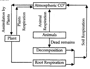
Q22. Explain in detail the carbon cycle. Draw and label the diagram. [5]
Ans: Carbon is one of the basic elements of all living organisms. It forms the basic constituent of all the organic compounds. The biosphere contains over half a million carbon compounds in them. The carbon cycle is mainly the conversion of carbon dioxide. This conversion is initiated by the fixation of carbon dioxide from the atmosphere through photosynthesis. Such conversion results in the production of carbohydrates and glucose that may be converted to other organic compounds such as sucrose, starch, cellulose, etc. Here, some of the carbohydrates are utilized directly by the plant itself.
During this process, more carbon dioxide is generated and is released through its leaves or roots during the day. The remaining carbo hydrates, not being utilized by the plant, become part of the plant tissue. Plant tissues are either eaten by herbivorous animals or get decomposed by microorganisms. The herbivores convert some of the consumed carbohydrates into carbon dioxide for release into the air through respiration. The microorganisms decompose the remaining carbohydrates after the animal dies. The carbohydrates that are decomposed by the micro-organisms then get oxidized into carbon dioxide and are returned to the atmosphere.
Q23. How is Bhangar different from Khadar? [5]
Ans: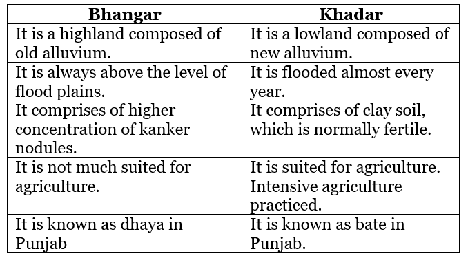
Q24. Explain the important features of the winter season of India. [5]
Ans: The important features of the winter season in India are:
(1) Usually, the cold weather season sets in by mid-November in Northern India. December and January are the coldest months in the Northern plain. The mean daily temperature remains below 21 °C over most parts of Northern India.
(2) The night temperature may be quite low, sometimes going below freezing point in Punjab and Rajasthan.
(3) The Peninsular region of India, however, does not have any well-defined cold weather season. There is hardly any seasonal change in the distribution pattern of the temperature in coastal areas because of the moderating influence of the sea and the proximity to the equator.
(4) The isobars of 1019 MB and 1013 MB pass through NorthWest India and far South, respectively. As a result, winds start blowing from the Northwestern high-pressure zone to the low-air-pressure zone over the Indian Ocean in the South.
(5) During the winter, the weather in India is pleasant. The pleasant weather conditions, however, at intervals, get disturbed by shallow cyclonic depressions originating over the Eastern Mediterranean Sea and traveling Eastwards across West Asia, Iran, Afghanistan, and Pakistan before they reach the North-Western parts of India.
Q25. Mention the causes responsible for soil erosion. [5]
Ans: The causes responsible for soil erosion are:
(1) Human activities: The soil forming processes and the erosion processes of running water and wind go on simultaneously. However, generally, there is a balance between these two processes Sometimes, such a balance is disturbed by natural or human factors, leading to a greater rate of removal of soil. Human activities too are responsible for soil erosion to a great extent. As the human population increases, the demand for land also increases. Forest and other natural vegetation are removed for human settlement, cultivation, grazing animals, and for various other needs.
(2) Slope Gradient and Length: The steeper and longer the slope of a field, the higher the risk of erosion. Soil erosion by water increases as the slope length increases due to the greater accumulation of runoff. Consolidation of small fields into larger ones often results in longer slope lengths with increased erosion potential, due to the increased velocity of water, which permits a greater degree of scouring (carrying capacity for sediment).
(3) Cropping and Vegetation: The potential for soil erosion increases if the soil has no or very little vegetative cover of plants and/or crop residues. Plant and residue cover protects the soil from raindrop impact and splash, it tends to slow down the movement of runoff water and allows excess surface water to infiltrate.
(4) Wind and water: Wind and water are powerful agents of soil erosion because of their ability to remove soil and transport it. Wind erosion is significant in arid and semi-arid regions. In regions with heavy rainfall and steep slopes, erosion by running water is more significant. Water erosion, which is more serious and occurs extensively in different parts of India, takes place mainly in the form of sheet and gullv erosion. Sheet erosion takes place on level lands after a heavy shower and the soil removal is not easily noticeable. However, it is harmful since it removes the finer and more fertile topsoil.
(5) Deforestation: Deforestation is one of the major causes of soil erosion. Plants keep soils bound in locks of roots, and thus, prevent erosion. They also add humus to the soil by shedding leaves and twigs. Forests have been denuded practically in most parts of India but their effect on soil erosion is more in hilly parts of the country.
Q26. Development can help in disaster management as well as cause management. Justify. [5]
Ans: Due to efforts with the help of the development of techniques to monitor the behavior of cyclones, their intensity, direction, and magnitude, it has become possible to manage the cyclonic hazard to some extent. Construction of cyclone shelters, embankments, dykes, reservoirs, and afforestation to reduce the speed of the winds are some of the steps that can help in minimizing the damages. Unwise, uncoordinated, or unsafe development can quickly and dramatically increase the disaster risk faced by the people of a country.
Practices that incorporate risk reduction methodologies, such as stringent building codes, resistant materials, proper land use planning, and other important mitigation measures and practices often reduce the likelihood of disaster events or the consequences that result when events do occur. Mass urbanization and coastal migration, which occur with little regard to wise building practices as is often seen in the megacities of the developing world are primary contributors to increased risk of development.
Q27. On the given map of the world five features are shown as A, B, C, D, and E. Identify the features with the help of the information given below and write their correct names on the map: [5]
A. An area of subsistence gathering
B. A major international airport
C. A terminal station of the Trans-Canadian Railway
D. The largest country in South America
E. A megacity
Ans: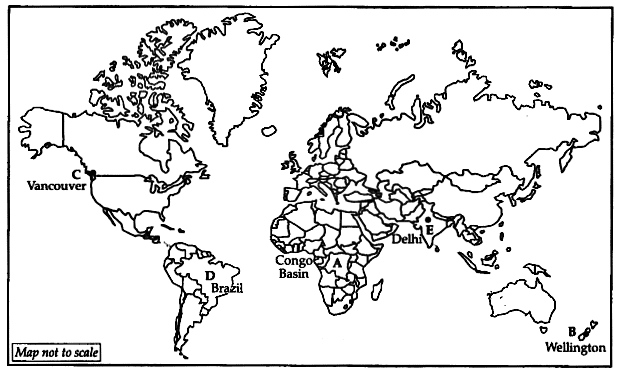
Q28. On an outline map of India mark the following using appropriate symbols: [5]
A. State with a high level of population density
B. A city with more than 10 million population in Maharashtra state
C. An iron-ore mine in Odisha state
D. A center of cotton textile in Gujarat state
E. An important node on the east-west corridor in Assam state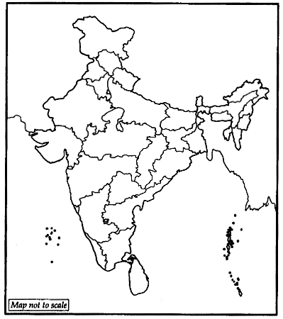
Ans: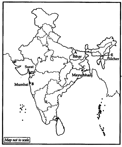
|
71 videos|245 docs|44 tests
|
FAQs on CBSE Sample Question Paper (2022-23) - 5 - Geography Class 11 - Humanities/Arts
| 1. What are the subjects included in the CBSE Sample Question Paper for Humanities/Arts? |  |
| 2. How can students effectively prepare for the Humanities/Arts exam based on the sample question paper? |  |
| 3. Is it necessary to solve all the questions in the CBSE Sample Question Paper for Humanities/Arts? |  |
| 4. Can students use the CBSE Sample Question Paper for Humanities/Arts as a reference for the board exam preparation? |  |
| 5. How can students utilize the CBSE Sample Question Paper for Humanities/Arts effectively for self-assessment? |  |

|
Explore Courses for Humanities/Arts exam
|

|


