Grade 6 Exam > Grade 6 Notes > Geography for Grade 6 > Chapter Notes: Europe
Europe Chapter Notes | Geography for Grade 6 PDF Download
| Table of contents |
|
| Introduction |
|
| Location and Boundaries of Europe |
|
| Countries and Capitals |
|
| Major Physical Features of Europe |
|
| Mountain Ranges |
|
| Seas and Oceans |
|
| Rivers |
|
| Lakes |
|
| Peninsulas of Europe |
|
| Islands |
|

Introduction
Europe, one of the seven continents, has a rich history with ancient civilizations like Greece and Rome, and it is the birthplace of democracy. It has been shaped by major events like World War I and World War II. Home to over 40 countries, Europe is known for its cultural diversity due to migration, cultural exchange, and shifting borders. The European Union unites many of these countries, allowing them to share a common currency and combine their economic and military strength. This chapter explores Europe's location, physical features, countries, rivers, lakes, seas, mountains, and peninsulas.Location and Boundaries of Europe
- Europe’s boundaries are not clearly defined but generally follow the Ural Mountains, Ural River, Caspian Sea, Manych River Valley, Sea of Azov, Black Sea, and Bosporus Strait.
- It is surrounded by the Arctic Ocean in the north, Atlantic Ocean in the west, and Mediterranean Sea in the south.
- The Strait of Gibraltar, only 13 km wide, separates Europe from Africa and Southwest Asia.
- Europe stretches from 35°N to 72°N latitudes and 25°W to 65°E longitudes.
- Greenland and small islands like the Canary Islands (Spain) and others (France, Portugal) are part of the European Union.
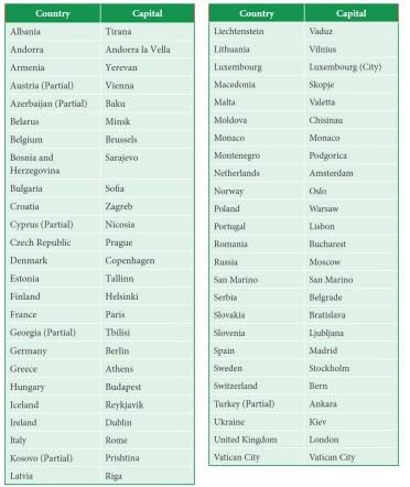
Countries and Capitals
Europe has 44 countries and 6 partial countries (those with limited sovereignty, geographical integration, or recognition).Countries and their capitals include:
Major Physical Features of Europe
- Europe’s land area is similar to the USA, with diverse landscapes including mountains, rivers, valleys, and lakes.
- Ithas three main layers: highlands in the far north, a central lowland plain, and a mountainous south.
- Europe is divided into four major physical regions: Northwestern Uplands, North European Plain, Central Uplands, and Alpine Mountains.
Northwestern Uplands
- Located along the western edge of Europe, covering Scandinavia (Norway, Sweden, Denmark), Finland, Iceland, Scotland, Ireland, Brittany (France), Spain, and Portugal.
- Formed by hard, ancient rocks shaped by glaciation, creating marshlands, lakes, and fjords.
- Fjords are deep glacial valleys filled with seawater, found in Iceland and Scandinavia, with steep sides.
North European Plain
- Covers parts of France, Belgium, Netherlands, Germany, Denmark, Poland, Belarus, Estonia, Latvia, and Lithuania.
- Also called North European Lowlands, bordered by the Ural Mountains in the east.
- Contains navigable rivers like Rhine, Weser, Elbe, Oder, and Vistula.
- Fertile soil supports seasonal crops, aiding early communication, travel, and agriculture.
- It is the most densely populated region in Europe.
Central Uplands
- Includes western France, Belgium, southern Germany, Czech Republic, northern Switzerland, and Austria.
- Less rugged than the Alpine region, heavily wooded, with an elevation of 230–250 meters.
- Key highlands include Massif Central and Vosges (France), Ardennes (Belgium), Black Forest and Taunus (Germany), Ore and Sudeten (Czech Republic).
- Sparsely populated except in the Rhine, Elbe, and Danube river valleys.
Alpine Mountains
- Covers ranges in Italy, Balkan Peninsula, northern Spain, and southern France, including Alps, Pyrenees, Apennines, Dinaric Alps, Balkans, and Carpathians.
- Features high elevations, rugged plateaus, and steep slopes.
- Mount Elbrus (5,642 meters) in Russia’s Caucasus Mountains is Europe’s highest peak.
- Includes active volcanoes like Mount Etna and Mount Vesuvius in Italy.
Mountain Ranges
Europe has dramatic mountain landscapes, including the Apennine, Pyrenees, Alps, Carpathian, and Ural Mountains.Apennine Mountains
- Located in Italy, stretching from Cadibona Pass near the Maritime Alps to the Egadi Islands near Sicily.
- Known as the “backbone” of Italy due to their shape and location.
- Highest peak is Corno Grande (2,912 meters).
- Made of sandstone and limestone.
Pyrenees Mountains
- Form a natural border between France and Spain, stretching 435 km from the Bay of Biscay to the Gulf of Lion.
- Highest peak is Aneto Peak (3,404 meters).
- A relatively young mountain range with national parks like Pyrenees National Park (France), around Cirque de Gavarnie.
Alps
- Youngest and highest mountain system in Europe, stretching across France, Italy, Switzerland, Liechtenstein, Germany, Austria, and Slovenia.
- Extends 1,095 km, with Mont Blanc (4,810 meters) as the tallest peak.
- Made of crystalline rock, limestone, and sedimentary rocks.
- Affects Europe’s climate by blocking cold northern winds, making southern areas warm, dry, and stable.
Carpathian Mountains
- Young mountains forming a crescent through several countries, with Gerlachov Peak (2,655 meters) as the highest point.
- Forms a border between Slovakia and Poland.
- Made of sandstone-shale and crystalline rock.
- Home to 35% of Europe’s brown bears, 40% of wolves, and 15% of lynxes.
Ural Mountains
- Located in Russia, stretching from the Arctic Ocean to central Russia and northern Kazakhstan.
- Highest peak is Mount Narodnaya (1,895 meters).
- Separates Europe’s prairies from Siberia in Asia.
- Rich in minerals, ores, precious stones, oil, and coal.
Seas and Oceans
- Europe is bordered by the Arctic Ocean (north), Atlantic Ocean (west), Mediterranean Sea, Black Sea, Caspian Sea (south), and Baltic Sea (north).
- Seas play a key role in maintaining Earth’s natural balance.
Baltic Sea
Located in northern Europe, bordered by Sweden, Finland, Russia, Estonia, Latvia, Lithuania, Poland, northeastern Germany, and eastern Denmark.Black Sea
- An inland sea between southeastern Europe, western Asia, and Turkey.
- Connects to the Mediterranean Sea via the Bosporus Strait, Sea of Marmara, Dardanelles Strait, Aegean Sea, and Sea of Crete.
- Bordered by Romania, Bulgaria, Ukraine, Russia, Georgia, and Turkey.
Mediterranean Sea
- A large sea between Europe, Africa, and Asia, stretching from the Strait of Gibraltar to the Dardanelles Strait and Suez Canal.
- Divided into Western Basin (Spain to Tunisia) and Eastern Basin.
Rivers
- Europe has around 1,352 freshwater rivers.
- Many rivers flow through the continent.
- Some rivers form boundaries between different countries.
- Others are used for farming and provide freshwater fish for food.
Volga River
- Europe’s longest river (3,690 km), starting in the Valdai Hills and draining into the Caspian Sea.
- Freezes for three months each winter.
- Provides natural gas, potash, salt, and other minerals.
Danube River
- Second longest river in Europe, starting in Germany’s Black Forest and flowing to the Black Sea.
- Forms the second largest delta in the world.
- Passes through ten countries and four capitals: Belgrade, Vienna, Budapest, and Bratislava.
Dniester River
- Flows through Ukraine and Moldova, then back to Ukraine, draining into the Black Sea (2,290 km).
- One of Europe’s longest rivers.
Ural River
- Flows through Russia and Kazakhstan, draining into the Caspian Sea.
- Used for hydroelectric power at the Iriklinsky reservoir.
Rhine River
- Flows 1,233 km through Switzerland, Austria, Liechtenstein, Netherlands, Germany, and France, draining into the North Sea.
- Originates in the Swiss Alps and is Germany’s longest river.
River Thames
- England’s longest river (346 km), second longest in the UK.
- Was a tributary of the Rhine before Britain separated from Europe during the last Ice Age, forming the English Channel.
Lakes
- Lakes in Europe are mostly freshwater but can be slightly salty.
- Many natural lakes are found in Norway, Sweden, Finland, and parts of Russia.
- Twenty-four lakes in Europe have a surface area larger than 400 square kilometers.
Caspian Sea
- The world’s largest lake, located in western Asia and eastern Europe.
- Bordered by Azerbaijan, Russia, Kazakhstan, Turkmenistan, and Iran.
Lake Ladoga
- Europe’s largest lake, located in Russia’s Republic of Karelia and Leningrad Oblast.
- 14th largest freshwater lake globally by area.
- Navigable, part of the Volga-Baltic Waterway connecting the Baltic Sea to the Volga River.
Lake Onega
- Second largest lake in Europe, located in northwestern Russia between Lake Ladoga and the White Sea.
- Water is dark yellowish-brown in the center and greyish-brown along the shores.
Lake Vänern
- Largest lake in Sweden and the European Union, third largest in Europe after Ladoga and Onega.
- Sweden has over 97,000 lakes.
Peninsulas of Europe
- Europe is a large peninsula extending west of Asia, often called a “peninsula of peninsulas.”
- Most locations in Europe are within 482 km of an ocean or sea.
- Water bodies are used for business and leisure.
Northern Peninsulas
- Scandinavian Peninsula: Includes Norway and Sweden, bounded by the Norwegian Sea, North Sea, and Baltic Sea. Shaped by glaciers, leaving rocky soil difficult for farming.
- Jutland Peninsula: Forms most of Denmark and a small part of Germany, with gently rolling hills and swampy lowlands, unlike the rocky Scandinavian Peninsula.
Southern Peninsulas
- Iberian Peninsula: Home to Spain and Portugal, separated from Europe by the Pyrenees Mountains.
- Italian Peninsula: Home to Italy, boot-shaped, extends into the Mediterranean Sea with 7,563 km of coastline.
- Balkan Peninsula: Bordered by the Adriatic, Ionian, Mediterranean, and Aegean Seas, mountainous with difficult transportation.
Islands
- Major islands include Great Britain, Ireland, Iceland, and Greenland in the North Atlantic Ocean.
- Iceland and Greenland have Scandinavian settlers with cultural ties to mainland Europe.
- Smaller Mediterranean islands include Corsica, Sardinia, Sicily, and Crete, occupied by various groups over centuries.
- All European islands rely on trade.
Points To Remember
- Europe is in the Northern Hemisphere, stretching from the Arctic Ocean to the Mediterranean Sea and from the Atlantic Ocean to the Ural Mountains.
- It is a moderate and prosperous region due to its location away from extreme climates.
- Four major physical regions: Northwestern Uplands, North European Plains, Central Uplands, and Alpine Mountains.
- Major mountain ranges: Apennine, Pyrenees, Alps, Carpathian, and Ural Mountains.
- Bordered by the Arctic Ocean, Atlantic Ocean, Mediterranean Sea, Black Sea, Caspian Sea, and Baltic Sea, with many rivers and lakes.
- Known as a “peninsula of peninsulas” with many islands.
- Northern Peninsulas: Scandinavian and Jutland; Southern Peninsulas: Iberian, Italian,
The document Europe Chapter Notes | Geography for Grade 6 is a part of the Grade 6 Course Geography for Grade 6.
All you need of Grade 6 at this link: Grade 6
|
38 docs|4 tests
|
FAQs on Europe Chapter Notes - Geography for Grade 6
| 1. What are the major countries and their capitals in Europe? |  |
Ans.The major countries in Europe include Germany (Berlin), France (Paris), Italy (Rome), Spain (Madrid), and the United Kingdom (London). Other notable countries include Portugal (Lisbon), Greece (Athens), and the Netherlands (Amsterdam).
| 2. What are the significant physical features of Europe? | |
Ans.Significant physical features of Europe include the Alps and the Pyrenees mountain ranges, the Danube and Rhine rivers, and the Mediterranean and North Seas. Europe is also known for its numerous lakes, such as Lake Geneva and Lake Balaton.
| 3. Which mountain ranges are prominent in Europe? | |
Ans.The prominent mountain ranges in Europe include the Alps, which stretch across several countries, the Pyrenees between France and Spain, and the Carpathians in Eastern Europe. The Apennines run through Italy, and the Scandinavian Mountains are found in Norway and Sweden.
| 4. What are some major rivers in Europe? | |
Ans.Major rivers in Europe include the Danube River, which flows through several countries including Germany and Hungary, the Rhine River running through Switzerland, Germany, and the Netherlands, and the Seine River in France. The Thames River is also significant in the UK.
| 5. What are some of the largest lakes in Europe? | |
Ans.Some of the largest lakes in Europe include Lake Ladoga in Russia, which is the largest by area, Lake Balaton in Hungary, and Lake Geneva, which is shared by France and Switzerland. Other notable lakes include Lake Como in Italy and the Caspian Sea, which is technically the largest enclosed inland body of water.
About this Document

4.95/5
Rating

Oct 15, 2025
Last updated
Related Exams
Document Description: Chapter Notes: Europe for Grade 6 2025 is part of Geography for Grade 6 preparation.
The notes and questions for Chapter Notes: Europe have been prepared according to the Grade 6 exam syllabus. Information about Chapter Notes: Europe covers topics
like Introduction, Location and Boundaries of Europe, Countries and Capitals, Major Physical Features of Europe, Mountain Ranges, Seas and Oceans, Rivers, Lakes, Peninsulas of Europe, Islands and Chapter Notes: Europe Example, for Grade 6 2025 Exam. Find important definitions, questions, notes, meanings, examples, exercises and tests below for Chapter Notes: Europe.
Introduction of Chapter Notes: Europe in English is available as part of our Geography for Grade 6
for Grade 6 & Chapter Notes: Europe in Hindi for Geography for Grade 6 course.
Download more important topics related with notes, lectures and mock test series for Grade 6
Exam by signing up for free. Grade 6: Europe Chapter Notes | Geography for Grade 6
Description
Full syllabus notes, lecture & questions for Europe Chapter Notes | Geography for Grade 6 - Grade 6 | Plus excerises question with solution to help you revise complete syllabus for Geography for Grade 6 | Best notes, free PDF download
Information about Chapter Notes: Europe
In this doc you can find the meaning of Chapter Notes: Europe defined & explained in the simplest way possible. Besides explaining types of
Chapter Notes: Europe theory, EduRev gives you an ample number of questions to practice Chapter Notes: Europe tests, examples and also practice Grade 6
tests

Related Searches
Europe Chapter Notes | Geography for Grade 6
,Summary
,Sample Paper
,practice quizzes
,ppt
,MCQs
,Exam
,study material
,Europe Chapter Notes | Geography for Grade 6
,mock tests for examination
,Europe Chapter Notes | Geography for Grade 6
,Important questions
,Objective type Questions
,video lectures
,past year papers
,Semester Notes
,Free
,Extra Questions
,Previous Year Questions with Solutions
,Viva Questions
,shortcuts and tricks
;


Additional Information about Chapter Notes: Europe for Grade 6 Preparation
Chapter Notes: Europe Free PDF Download
The Chapter Notes: Europe is an invaluable resource that delves deep into the core of the Grade 6 exam.
These study notes are curated by experts and cover all the essential topics and concepts, making your preparation more efficient and effective.
With the help of these notes, you can grasp complex subjects quickly, revise important points easily,
and reinforce your understanding of key concepts. The study notes are presented in a concise and easy-to-understand manner,
allowing you to optimize your learning process. Whether you're looking for best-recommended books, sample papers, study material,
or toppers' notes, this PDF has got you covered. Download the Chapter Notes: Europe now and kickstart your journey towards success in the Grade 6 exam.
Importance of Chapter Notes: Europe
The importance of Chapter Notes: Europe cannot be overstated, especially for Grade 6 aspirants.
This document holds the key to success in the Grade 6 exam.
It offers a detailed understanding of the concept, providing invaluable insights into the topic.
By knowing the concepts well in advance, students can plan their preparation effectively.
Utilize this indispensable guide for a well-rounded preparation and achieve your desired results.
Chapter Notes: Europe
Chapter Notes: Europe Notes offer in-depth insights into the specific topic to help you master it with ease.
This comprehensive document covers all aspects related to Chapter Notes: Europe.
It includes detailed information about the exam syllabus, recommended books, and study materials for a well-rounded preparation.
Practice papers and question papers enable you to assess your progress effectively.
Additionally, the paper analysis provides valuable tips for tackling the exam strategically.
Access to Toppers' notes gives you an edge in understanding complex concepts.
Whether you're a beginner or aiming for advanced proficiency, Chapter Notes: Europe Notes on EduRev are your ultimate resource for success.
Chapter Notes: Europe Grade 6 Questions
The "Chapter Notes: Europe Grade 6 Questions" guide is a valuable resource for all aspiring students preparing for the
Grade 6 exam. It focuses on providing a wide range of practice questions to help students gauge
their understanding of the exam topics. These questions cover the entire syllabus, ensuring comprehensive preparation.
The guide includes previous years' question papers for students to familiarize themselves with the exam's format and difficulty level.
Additionally, it offers subject-specific question banks, allowing students to focus on weak areas and improve their performance.
Study Chapter Notes: Europe on the App
Students of Grade 6 can study Chapter Notes: Europe alongwith tests & analysis from the EduRev app,
which will help them while preparing for their exam. Apart from the Chapter Notes: Europe,
students can also utilize the EduRev App for other study materials such as previous year question papers, syllabus, important questions, etc.
The EduRev App will make your learning easier as you can access it from anywhere you want.
The content of Chapter Notes: Europe is prepared as per the latest Grade 6 syllabus.
|
© EduRev
|
Education Revolution
|


|


Signup on EduRev and stay on top of your study goals
10M+ students crushing their study goals daily