Landforms and Life Chapter Notes | Chapter Notes For Class 6 PDF Download
| Table of contents |

|
| Introduction |

|
| Mountains |

|
| Plateaus |

|
| Plains |

|
| Glossary |

|
Introduction
Imagine an exciting road trip—starting in the rugged hills of Chhota Nagpur, passing through the fertile plains of Prayagraj, and ending in the scenic town of Almora. On this journey, you’ll witness the fascinating variety of landscapes, each unique and awe-inspiring. These different types of land are called landforms.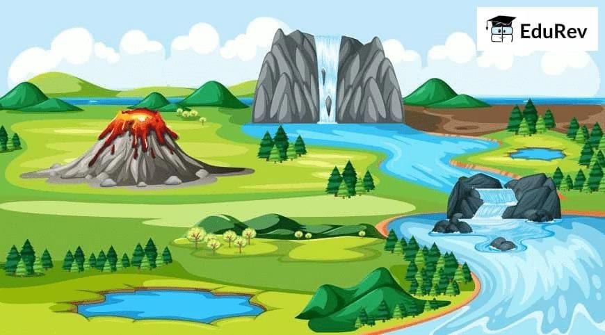 Landforms
A landform is a physical feature on the surface of our planet Earth. Landforms take shape over millions of years and have a significant connection with the environment and life. They can broadly be divided into three categories - mountains, plateaus, and plains. These landforms have different climates and support a variety of flora and fauna. Throughout history, the lives and activities of people have been greatly influenced by the type of landform they have inhabited.
Mountains
- Mountains are landforms that are significantly higher than the surrounding landscape. They are characterised by a broad base, steep slopes, and a narrow summit. Depending on their height, some mountains are covered with snow.
- In the summer, the snow on lower mountains melts, turning into water that feeds rivers. On higher mountains, the snow might never melt, keeping them covered in snow all year long.
- Hills are like mountains but are shorter, have gentler slopes, and rounded tops. Most mountains in the world are part of mountain ranges, which are long chains of mountains. Examples include the Himalayas in Asia, the Alps in Europe, and the Andes in South America. Some of these ranges stretch for thousands of kilometers.
- Mount Everest, located between Tibet (China) and Nepal, and Kanchenjunga, between Nepal and the Indian state of Sikkim, are the two highest peaks in the Himalayas.
 Mount Everest
 - In South America, Mount Aconcagua is the highest peak of the Andes. Mount Kilimanjaro in eastern Africa is a tall, isolated mountain not part of any range.
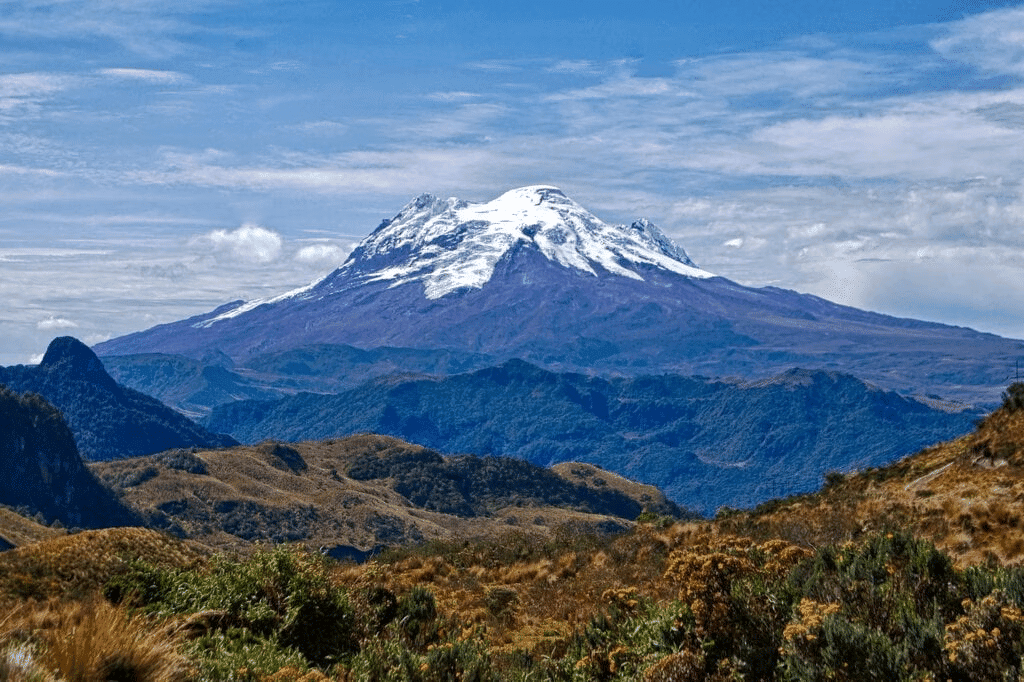 Andes
Andes - Mont Blanc is the highest mountain in the Alps in Western Europe. Anamudi, also known as 'Anai Peak,' is the highest mountain in South India, located in Kerala.
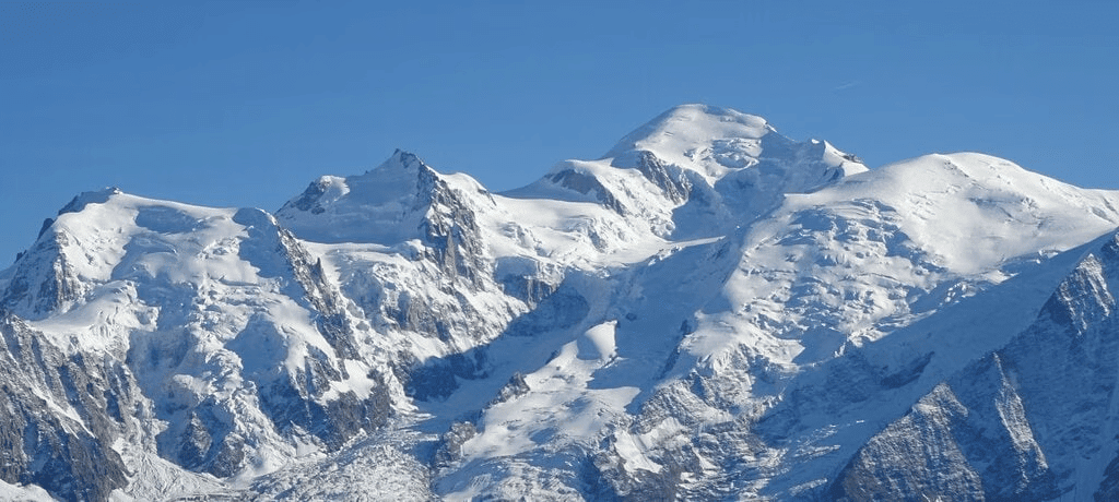 Mount Blanc
 - Mountains with tall, sharp peaks like the Himalayas are considered 'young,' meaning they formed recently in Earth's history, although that still means millions of years ago! Older mountains, like the Aravalli Range, have shorter and more rounded peaks because they have been worn down by erosion over time.
- Some mountains, like the Himalayas, are still growing in height due to ongoing natural processes.
Mountain Environment
- Mountain slopes are often covered with a special type of forest called montane forest, where conifer trees such as pines, firs, spruce, and deodar are common.
- These conifer trees grow tall and cone-shaped, with thin, pointed leaves. As you go higher up the mountain, the trees start to disappear, and instead, you'll find grasses, mosses, and lichen growing.
- These trees have thin, pointed leaves that help them survive in the cooler mountain climate. As you go higher up the mountain, the trees start to disappear, and instead, you'll find grasses, mosses, and lichen growing.
- Mountains are also home to a wide variety of animals. In the deep forests, near rivers, lakes, grasslands, and even in caves, you can find animals like the golden eagle, peregrine falcon, Canadian lynx, snow leopard, ibex, Himalayan tahr, mountain hare, yak, grey fox, and black bear.
- These creatures have adapted to live in the unique environment that mountains provide.

The Himalayas in Ancient Poetry
- These verses are from a poem written by Kalidasa, a famous poet who lived over 1,500 years ago in ancient India. The poem, Kumarasambhava, starts by praising the Himalayas.
- The poem describes the Himalayas as a mighty mountain range that stretches from the west to the east, almost like a living god that covers the Earth.
- The wind that blows from the Himalayas carries the mist from the Ganga River, makes the deodar trees shake, and causes the peacocks to spread their feathers. The cool breeze also refreshes the mountain people after they go hunting.
Let's Revise
Q: What kind of trees are found in montane forests?
 View Answer
Ans: Montane forests have tall, cone-shaped trees like pines, firs, spruce, and deodar.
Q: Name two animals that live in mountain environments.
 View Answer
Ans: Animals like the snow leopard and golden eagle live in mountain environments.
Life in the Mountains
- Mountain terrain is usually rough and has steep slopes, so regular farming is mostly done in some valleys.
- Terrace farming is practised by cutting steps into the slopes for cultivation.
- In many mountainous areas, herding animals is more common than farming.
- Tourism is a major source of income in the mountains because people are attracted to the fresh air and beautiful scenery.
- Tourists often visit for activities like skiing, hiking, mountaineering, and paragliding.
- People have also been visiting mountains for religious pilgrimages for many centuries.
- However, too many visitors can harm the delicate mountain environment, making it important to find a balance.

Inspiring Mountain Climbers
1. Bachendri Pal: A Pioneer in Women's Climbing
- Bachendri Pal started climbing mountains when she was young and led many women's climbing expeditions.
- She became the first Indian woman to climb Mount Everest in 1984 and was awarded the Padma Shri that same year and the Padma Bhushan in 2019.
2. Arunima Sinha: Overcoming Adversity
- Arunima Sinha lost a leg in an accident at age 31.
- With Bachendri Pal's support and training, she climbed Mount Everest in 2013 and later climbed the highest peaks on every continent, including Mount Vinson in Antarctica.
- She received the Padma Shri in 2015.
Sacred Mountains Around the World
- Many traditional communities around the world see mountains as sacred and worship them. Mount Everest, the highest mountain at 8,849 meters, is known by different names.
- Tibetans call it 'Chomolungma,' meaning 'Mother Goddess of the World,' and worship it. Nepalis call it 'Sagarmatha,' meaning 'Goddess of the Sky.'
- Mount Kailash in Tibet is also considered sacred by people who follow Hinduism, Buddhism, Jainism, and Bon (an ancient Tibetan religion). Respect for mountains as holy places is common in India and many other parts of the world.
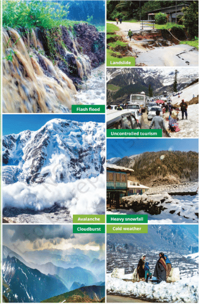 Life in the mountains has definite positives, from pure air to the beautiful scenery. It also involves potential challenges, both natural and human-made, some of which are depicted in these pictures.
Don't Miss Out
- Many traditional communities around the world consider mountains to be sacred places and worship them. Mount Everest, the highest mountain in the world at 8,849 meters, has many names.
- Tibetans call it ‘Chomolungma’, which means ‘Mother Goddess of the World’ and worship the mountain as such. Nepalis call it ‘Sagarmatha’, meaning ‘Goddess of the Sky’.
- Similarly, Mount Kailash in Tibet is held sacred by followers of Hinduism, Buddhism, Jainism and Bon (an ancient Tibetan religion). Such reverence for mountain summits is also found elsewhere in India, as well as in other parts of the world.
Plateaus
- A plateau is a landform that stands higher than the land around it and has a flat top. Some of its sides are steep. Like mountains, plateaus can be old or young in the Earth’s history.
- The Tibetan Plateau is the largest and highest plateau in the world, and the Deccan Plateau is another well-known example. Plateaus can vary in height from a few hundred meters to several thousand meters.
- Plateaus are rich in minerals, which is why mining is a major activity in these areas. For example, the East African Plateau is famous for gold and diamond mining, and in India, the Chhota Nagpur Plateau has large reserves of iron, coal, and manganese.
- The environment on plateaus is diverse. Many plateaus have rocky soil, which makes farming difficult. However, lava plateaus (formed by volcanic activity) often have rich black soil that is good for farming.
- Plateaus are also known for their beautiful waterfalls. Some famous ones include Victoria Falls in southern Africa, Hundru Falls on the Subarnarekha River in the Chhota Nagpur Plateau, Jog Falls on the Sharavati River in the Western Ghats, and Nohkalikai Falls in Meghalaya, which drops 340 meters from the Cherrapunji Plateau.
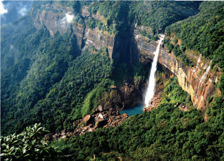 The Nohkalikai Falls emerging from the Cherrapunji Plateau
The Tibetan and Deccan Plateaus
- The Tibetan Plateau is very high, with an average height of 4,500 meters, which is why it’s called the 'Roof of the World.'
- It stretches about 2,500 kilometers from east to west, which is the same distance as from Chandigarh to Kanyakumari.
- The Deccan Plateau in central and southern India is one of the oldest plateaus in the world, formed by volcanic activity millions of years ago.
Plains
- Plains are large areas of flat or gently rolling land without any significant hills or deep valleys. They are usually no more than 300 meters above sea level.
- One special type of plain is called a floodplain. Floodplains are formed by rivers that come from mountain ranges. These rivers carry tiny particles of rock, sand, and silt, known as sediments, down to the plains.
- When the rivers deposit these sediments, the soil becomes very fertile, making it perfect for growing all kinds of crops. Because of this, agriculture is a major activity in plains. Additionally, plains are home to a wide variety of plants and animals.

Life in the Plains
- Thousands of years ago, the first civilizations developed near rivers in fertile plains. Even today, many people live in plains because they are good for farming and other activities.
- In India, about 400 million people live in the Ganga plain, also known as the 'Gangetic plain.' People in this region mainly work in farming and river fishing.
- They grow food crops like rice, wheat, maize, barley, and millets, as well as fiber crops like cotton, jute, and hemp. Traditionally, farming relied on rainfall for water, but in recent years, irrigation has become common, with water brought to fields through canals or pumped from the ground.
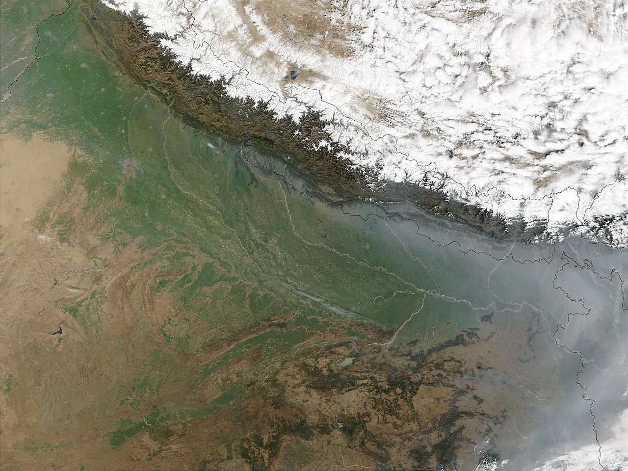 A Satellite View of Ganga Plain
- While irrigation has helped increase crop production, it has also caused a decrease in groundwater levels, which is a concern for the future.
- The Ganga plains also face challenges like high population and pollution.
- Rivers have always held cultural importance. Many communities consider a river's source or the place where rivers meet to be sacred. In India, many festivals and ceremonies are held at these locations.
- Because plains have a gentle slope, rivers are easy to navigate, which supports economic activities. In the past, people used rivers to travel, and even today, some stretches of the Ganga are still used for boat travel.
The Five Tinais of Ancient Tamil Sangam Poetry
In ancient Tamil Sangam poetry, the land was divided into five distinct landscapes, known as tinais. Each tinai is linked to specific deities, ways of life, and feelings such as love, longing, separation, and quarrel. These landscapes also relate to particular human activities.  The five tinais and their characteristics are as follows:
- Kurinji: Represents mountainous regions where hunting and gathering were the main occupations.
- Mullai: Refers to grasslands and forests, where cattle rearing was common.
- Marudam: Describes fertile agricultural plains, where farming was the primary activity.
- Neydal: Represents coastal regions, where people engaged in fishing and seafaring.
- Palai: Refers to arid, desert-like regions, where journeying and fighting were typical occupations.
These five tinais offer a different way to classify landforms than what we usually see, but they show a strong understanding of the various regions and their features. They also highlight the deep connection between people and the natural world. While you don’t need to memorise the details of the tinais, it is important to grasp the concepts they represent.
Glossary
- Altitude: The height of an object above Sea level. Examples: the altitude of a mountain, the altitude of a bird or plane in flight, the altitude of a satellite.
- Precipitation: Water from the atmosphere reaching the ground in any form — rain, snow and hail are the most common forms of precipitation.
- Montane forest: A type of forest that grows in mountainous regions.
- Moss: A small green plant without flowers or true roots, often spreading in a cushion-like cover.
- Lichen: A plant-like organism that generally clings to rocks, walls or trees.
- Terrain: A piece or stretch of land, from the point of view of its physical features.
- Valley: A lower area between hills or mountains, often with a river or stream flowing through it.
- Flash flood: A sudden local flood, often caused by a cloudburst.
- Landslide: The sudden collapse of a mass of earth or rock from a mountainside.
- Avalanche: The sudden fall of snow, ice or rocks from a mountainside; often occurs when the snow starts melting.
- Cloudburst: A sudden violent rainstorm.
- Sea level: The average level of the surface of the oceans, also called 'mean sea level'.
- Confluence: The meeting point of two or more rivers.
- Resilience: The capacity to meet challenges and difficulties, adapt to them or overcome them.
FAQs on Landforms and Life Chapter Notes - Chapter Notes For Class 6
| 1. What are the three main types of landforms discussed in the article? |  |
| 2. How are mountains formed? |  |
| 3. What are some examples of famous mountain ranges around the world? |  |
| 4. What is the significance of plateaus in terms of agriculture and human settlement? |  |
| 5. How do plains differ from mountains and plateaus in terms of topography and vegetation? |  |


