Class 6 Social Science: Sample Paper Solutions - 4 | Sample Papers For Class 6 PDF Download

Time: 3 hrs
Total Marks: 80
General Instructions:
- The question paper consists of 34 questions and is divided into four sections: A, B, C, and D.
- All questions are compulsory.
- Section A comprises question numbers 1 to 15. These are multiple-choice questions carrying one mark each. You are to select one most appropriate response out of the four provided options.
- Section B comprises question numbers 16 to 22. These are short-answer questions carrying two marks each.
- Section C comprises question numbers 23 to 31. These are short-answer questions carrying four marks each.
- Section D comprises question numbers 32 to 34. These are short-answer questions carrying five marks each.
Section A
Q1: If a map’s scale shows 1 cm equals 500 km, and two points on the map are 3.5 cm apart, what is the real distance between them? (1 Mark)
(a) 1,500 km
(b) 1,750 km
(c) 2,000 km
(d) 2,500 km
Ans: b
Scale calculation: 3.5 cm × 500 km/cm = 1,750 km, matching option b.
Q2: What is the primary reason oceans are not truly separate despite being named individually? (1 Mark)
(a) Seawater flows freely across their boundaries
(b) Marine life migrates between them constantly
(c) They share the same climate patterns
(d) Human conventions blur their natural divisions
Ans: a
Oceans connect physically, with water flowing across named boundaries (e.g., Atlantic to Pacifi(c), not just due to migration or conventions.
Q3: What metal did the Harappans mix with copper for tools? (1 Mark)
(a) Iron
(b) Tin
(c) Gold
(d) Silver
Ans: b
Harappans alloyed copper with tin to make bronze, enhancing tool durability, predating iron use.
Q4: What is the significance of the Vedic mantra "ekam sat vipra bahudhā vadanti" in understanding early Indian beliefs? (1 Mark)
(a) It emphasizes the worship of multiple gods over a single deity
(b) It suggests that truth is one but expressed in many ways
(c) It promotes the separation of human life from cosmic order
(d) It denies the existence of divine essence in nature
Ans: b
This Rig Veda mantra means “truth is one, sages call it by many names,” showing unity beneath diverse expressions.
Q5: What are wards in the context of urban local governance? (1 Mark)
(a) Military divisions
(b) Rural administrative units
(c) Divisions within cities for better governance
(d) National electoral divisions
Ans: c
Wards are city subdivisions for localized governance, not rural, military, or national units.
Q6: Why do parallels of latitude decrease in size as you move from the Equator toward the poles? (1 Mark)
(a) The Earth’s rotation compresses them near the poles
(b) They are imaginary circles that get smaller on a spherical surface
(c) Longitude lines shorten them as they converge
(d) The climate zones shrink them toward the poles
Ans: b
On a sphere, latitude circles shrink from the Equator (largest) to poles (points), due to geometry, not rotation or longitude.
Q7: Which expert studies fossils to uncover the history of plants, animals, and humans from millions of years ago? (1 Mark)
(a) Geologist
(b) Palaeontologist
(c) Anthropologist
(d) Archaeologist
Ans: b
Palaeontologists study fossils for ancient life history, unlike geologists (rocks), anthropologists (humans), or archaeologists (artifacts).
Q8: What significant impact have Sarpanchs had on local governance? (1 Mark)
(a) No impact on governance
(b) Improved local infrastructure and community projects
(c) Only managed cultural festivals
(d) Decreased community involvement
Ans: b
Sarpanchs lead Gram Panchayats, driving infrastructure (e.g., roads) and projects, enhancing rural life.
Q9: How do tribal traditions, such as those of the Todas in the Nilgiris, demonstrate a belief similar to Hinduism? (1 Mark)
(a) They reject all forms of divinity
(b) They view natural elements as sacred and linked to a supreme being
(c) They focus solely on material wealth and possessions
(d) They deny the interdependence of living creatures
Ans: b
Like Hinduism, Todas revere nature (e.g., mountains) as divine, tied to a higher power, not rejecting divinity.
Q10: Why might historians find contradictory information when reconstructing the past? (1 Mark)
(a) Sources like inscriptions and genetics always align perfectly
(b) Different sources, such as artifacts and texts, may not agree, requiring judgment
(c) Early humans left no reliable records
(d) Timelines erase conflicting events over time
Ans: b
Varied sources (e.g., texts vs. archaeology) often conflict, needing historians’ interpretation, not due to no records or timelines.
Q11: What role do feelings play in non-economic activities? (1 Mark)
(a) They decrease the importance of these activities
(b) They lead to financial profit
(c) They motivate actions out of gratitude, love, or duty
(d) They are irrelevant in non-economic decisions
Ans: c
Non-economic acts (e.g., caregiving) are driven by emotions like love or duty, not profit or irrelevance.
Q12: Which plateau is known as the "Roof of the World" due to its average altitude of 4,500 meters? (1 Mark)
(a) Deccan Plateau
(b) Chhota Nagpur Plateau
(c) Tibetan Plateau
(d) East African Plateau
Ans: c
The Tibetan Plateau’s high altitude (4,500 m) earns it the “Roof of the World” title, unlike lower plateaus.
Q13: What natural boundaries define "Bhārata" as described in an ancient text as lying north of the ocean and south of the snowy mountains? (1 Mark)
(a) The Arabian Sea and the Himalayas
(b) The Bay of Bengal and the Deccan Plateau
(c) The Indus River and the Thar Desert
(d) The Ganga River and the Vindhya Range
Ans: a
Ancient texts place Bhārata between oceans (Arabian Sea, Bay of Bengal) and snowy Himalayas, not internal features.
Q14: What would likely happen if there were no rules in society? (1 Mark)
(a) Increased freedom for all
(b) No significant change
(c) Disorder and inability to function smoothly
(d) More efficient governmental operations
Ans: c
Rules maintain order; without them, chaos would disrupt societal functions, not enhance freedom or efficiency.
Q15: In ancient Tamil Sangam poetry, which landscape is associated with hunting and gathering as the main occupation? (1 Mark)
(a) Mullai
(b) Kurinji
(c) Marudam
(d) Palai
Ans: b
Kurinji (hilly regions) in Sangam poetry links to hunting/gathering, unlike Mullai (forests) or Marudam (plains).
Section B
Q16: Why are meridians semicircle? (2 Marks)
Ans: Meridians are semicircles because they stretch from the North Pole to the South Pole, forming half-circles around the Earth’s surface, unlike flat latitude lines. They connect the poles in a curved path, helping measure east-west positions in degrees from the Prime Meridian. For example, the meridian at 77°E runs through India, curving to link the poles. This shape reflects Earth’s roundness, making them key for locating places like Delhi accurately on a globe.
Q17: How does Europe’s shape affect it? (2 Marks)
Ans: Europe’s jagged coastline, with many peninsulas and bays, boosts trade and fishing, its closeness to seas shaped its history. Unlike landlocked regions, this shape gave countries like Greece easy sea access, growing rich through ancient trade routes. For example, ports along the Mediterranean helped Europe connect with Asia and Africa. This coastal edge made it a hub for ships and fishers long ago, unlike inland areas far from water.
Q18: How do plateaus store minerals? (2 Marks)
Ans: Plateaus store minerals like coal and iron because they’re old, stable landforms where Earth’s crust pushed up metals millions of years ago. The Deccan Plateau in India, for instance, is mined for treasures hidden deep in its rocks. These minerals formed when lava cooled or Earth shifted long back. Mining taps these resources, supporting industries and jobs, making plateaus valuable despite their rugged look.
Q19: Why are tools prehistory’s key clues? (2 Marks)
Ans: Tools are prehistory’s key clues because they’re physical proof of how early humans lived before writing. A stone axe, for example, shows they hunted or cut wood, revealing skill and survival tricks without words. Found buried in soil, these objects tell us about their daily life and needs. Unlike stories, tools give solid evidence of the past, connecting us to people from thousands of years ago.
Q20: Why is the Arabian Sea vital? (2 Marks)
Ans: The Arabian Sea is vital for trade and fishing, linking India’s west coast to places like Arabia. It brings monsoon winds that water crops in states like Kerala, and ports like Mumbai thrive on its routes. Fishermen along the coast depend on it for fish like mackerel. This sea has shaped India’s economy and climate for centuries, making it a lifeline for millions.
Q21: How did Harappans store water? (2 Marks)
Ans: Harappans stored water in wells and tanks lined with baked bricks, dug deep to reach groundwater. These structures, found in cities like Mohenjo-Daro, show they planned for dry seasons to keep water flowing. Some wells were over 10 meters deep, proving their engineering skill. This ensured cities stayed alive even when rivers ran low, supporting their big populations.
Q22: What does the Arthashastra reveal? (2 Marks)
Ans: The Arthashastra, written by Chanakya, reveals ancient ideas on ruling, like taxing fairly or using spies for safety explains its role in India’s past. It offers tips for kings, such as building strong armies or managing money, showing early political thinking. For example, it suggests storing grain for emergencies. This text highlights how smart and organized ancient Indian leaders were, influencing governance even today.
Section C
Q23: (i) What are parallels of latitude?
(ii) How do they differ from meridians? (4 Marks)
Ans: (i) Parallels of latitude are horizontal lines circling Earth, like the Equator at 0°, measuring north-south distance in degrees from 0° to 90°,. They help locate places, like India mostly between 8°N and 37°N.
(ii) They differ from meridians, which are vertical semicircles running pole to pole, measuring east-west from the Prime Meridian. Parallels never meet and stay the same distance apart, while meridians converge at the poles. For example, the Equator stays wide, but meridians narrow near the Arctic. This difference makes them work together to pinpoint any spot, like Delhi at 28°N, 77°E, on a map.
Q24: (i) What is a peninsula?
(ii) Name one in India. (4 Marks)
Ans: (i) A peninsula is a landmass surrounded by water on three sides, jutting out from a continent like a finger into the sea. It’s tied to land on one side, unlike an island, and often has coasts good for trade or fishing.
(ii) The Deccan Peninsula in India is a big example, stretching into the Indian Ocean with the Arabian Sea to its west, Bay of Bengal to its east, and southern coast open to water, its triangular shape, covering much of southern India. This peninsula’s rivers and ports, like those in Tamil Nadu, have shaped life there for ages.
Q25: (i) How do deserts challenge life?
(ii) Name one desert activity in India. (4 Marks)
Ans: (i) Deserts challenge life with no water and extreme heat, making farming and living hard without special methods. Daytime burns, nights freeze, and scarce rain forces people to dig wells or use animals like camels to survive.
(ii) In India’s Thar Desert, camel trading is a key activity, where people buy and sell camels to move goods across the sandy expanse. Camels carry loads where vehicles can’t go, helping traders and herders earn a living. This shows how desert folk adapt to tough conditions with clever ways, keeping their economy alive.
Q26: (i) What are sculptures as sources?
(ii) Give an Indian example. (4 Marks)
Ans: (i) Sculptures are carved figures from the past, often of stone or metal, showing art, gods, or leaders.They give clues about old beliefs, skills, and daily life, standing as silent history lessons.
(ii) The Ashoka Pillar in India, with its four lions on top, is an example from the Mauryan era, found at Sarnath. It shows Emperor Ashoka’s power and Buddhist messages, still admired for its craft. Historians use it to learn about his rule and India’s artistic past, making it a treasure of our heritage.
Q27: (i) What is the Eastern Ghats’ role?
(ii) How does it differ from the Western Ghats? (4 Marks)
Ans: (i) The Eastern Ghats are lower hills along India’s east coast, holding forests and guiding rivers like the Godavari to the Bay of Bengal. They’re less tall but vital for eastern states like Andhra Pradesh, supporting wildlife and water flow.
(ii) They differ from the Western Ghats, which are higher, wetter, and block more rain, making the west lush while the east stays drier. For example, Kerala gets soaked, but Tamil Nadu behind the Eastern Ghats is less rainy. This contrast shapes farming and climate across India’s south, showing their unique roles.
Q28: (i) What were Harappan toys like?
(ii) What do they tell us? (4 Marks)
Ans: (i) Harappan toys were small clay animals like bulls or birds, and carts with wheels, simple yet detailed, found in homes across cities like Harappa.They were handmade, showing care in their making.
(ii) They tell us that kids played, and adults had craft skills, suggesting a society with time for fun beyond survival, per the textbook (Ch 6). Wheeled carts hint at early ideas of transport too. These finds show Harappans lived full lives—working, trading, and enjoying creativity—giving us a peek into their world 4,500 years ago.
Q29: (i) What are the Puranas?
(ii) How do they shape stories? (4 Marks)
Ans: (i) The Puranas are ancient texts written after the Vedas, full of myths about gods, kings, and the world. They mix history with tales, like Vishnu’s adventures, to teach morals in a fun way.
(ii) They shape stories like Vishnu saving Earth as a boar, inspiring epics and festival tales like Deepavali, still told today\. These stories pass down values like bravery and goodness, keeping culture alive. For example, kids hear them from elders, linking past to present in India’s traditions.
Q30: (i) How do languages unite India?
(ii) Name one language from the south. (4 Marks)
Ans: (i) Languages unite India because many, like Hindi and Bengali, share Sanskrit roots, and people often learn others, blending cultures despite differences. This mixing happens in schools, markets, and films, tying regions together.
(ii) Tamil from the south is an ancient language, rich in poetry like the Sangam works, and widely spoken in Tamil Nadu, per the textbook (Ch 8). It adds to India’s diverse mix, standing strong with its own script and history. Together, languages build a shared Indian identity through words and stories.
Q31: What are some of the rules you follow in your family and neighbourhood? Why are they important? (4 Marks)
Ans: Some general rules in my family and neighbourhood are as follows:
I. In the Family:
(a) Respectful Communication: This might involve using kind words, listening attentively, and resolving conflicts peacefully.
(b) Chores and Responsibilities: Contributing to household tasks teaches responsibility, time man-agement, and life skills.
(c) Curfews and Screen Time Limits: These rules promote healthy sleep habits, a balance between screen time and other activities, and personal safety (especially for nighttime curfews).
(d) Honesty and Truthfulness: Building trust is essential within a family. Honesty allows parents to provide guidance and support when needed.
II. In the Neighbourhood
(a)Property Respect: This involves not damaging other people’s property, being mindful of noise levels, and keeping the Neighbourhood clean.
(b) By following these rules, I have learnt valuable life skills and have become a responsible member of my family and neighbourhood.
Section D
Q32: What is the Zila Parishad’s role? How does it support rural areas? (5 Marks)
Ans:
- The Zila Parishad is the district-level body above Panchayat Samitis, led by elected members overseeing many villages.
- Its role is to plan large projects like hospitals or main roads, approve budgets, and manage schools across the district.
- It meets to hear block-level needs, like more teachers, and distributes government funds fairly to meet them.
- For example, it might set up a training center for farmers.
- It supports rural areas by linking them to state help, funding big needs like a dam for irrigation or clinics for health, beyond what villages can do alone.
- In a district like Pune, it ensures all villages get water pipes or electricity, not just a few.
- This lifts rural life—better crops, education, and care—making every corner grow stronger together.
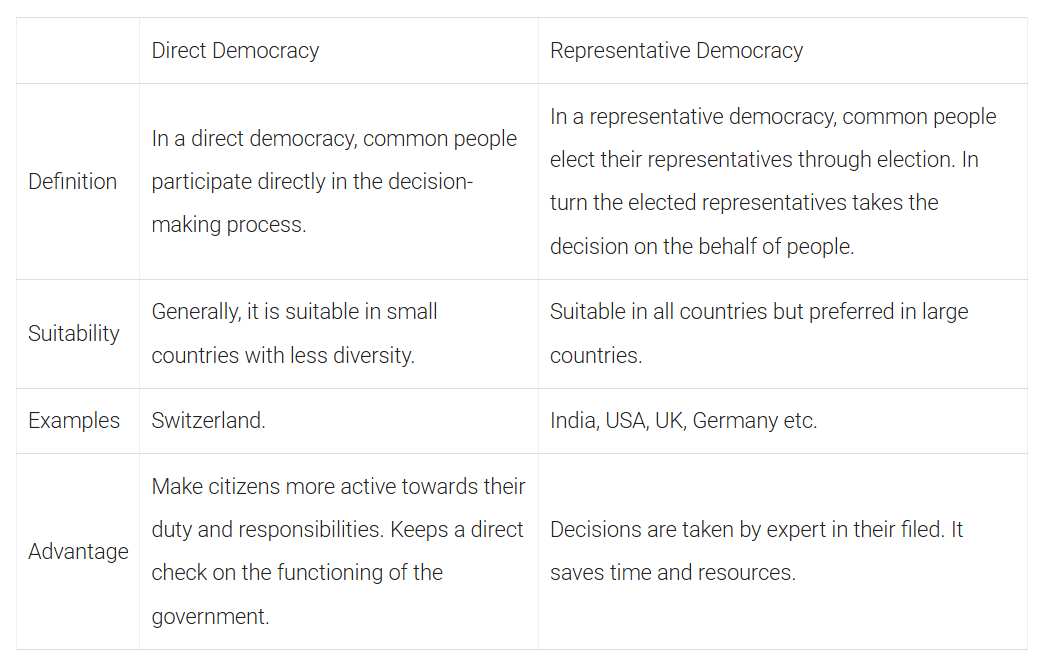
Q33: What is the meaning of democracy? What is the difference between direct democracy and representative democracy? (5 Marks)
Ans: Democracy is a system of government in which people choose their own rulers. The word ‘democracy’ comes from two Greek words — demos meaning ‘people’, and kratos meaning ‘rule’ or ‘power’; so ‘democracy’ means the ‘rule of the people’.
Direct and representative are part of democratic government and they mainly differs on the process of decision making.
Q34: During October-November, many major festivals take place in India. Make a list of the few main ones and their various names in different parts of the country. (5 Marks)
Ans: October-November is a vibrant period in India, marked by several major festivals celebrated across the country. Here are a few main ones and tfreir various names in different regions:
1. Diwali (Deepavali) - North India: Diwali, South India: Deepawali, West India (Maharashtr(a): Diwali, East India (Bengal): Kali Puja/Shyama Puja2. Dussehra (Vijayadashami)- North India: Dussehra, South India (Karnatak(a): Dasara, West Bengal: Durga Puja, Andhra Pradesh and Telangana: Vijaya Dashami, Maharashtra: Dasara
3. Navratri- North India: Navratri, West Bengal: Durga Puja, Gujarat: Navratri/Garba/ Dandiya, South India: Bommai Golu/ Gombe Habba
4. Bhai Dooj (Bhaiya Dooj)- North India: Bhai Dooj / Bhaiya Dooj, West Bengal: Bhai Phonta, Maharashtra: Bhau Beej, Gujarat: Bhai Beej
5. Chhath Puja- Bihar and Jharkhand: Chhath Puja, Uttar Pradesh: Surya Shashti, Other parts of India: Celebrated mainly in Bihar, Jharkhand, and Uttar Pradesh with growing popularity in other regions.
6. Govardhan Puja- North India: Govardhan Puja, Maharashtra: Annakut, Gujarat: Annakut
In conclusion, the festival season in India during October- November showcases the country’s rich cultural diversity. Each festival has its unique customs, rituals, and regional variations. Despite these differences, the essence of joy, devotion, and community bonding remains a unifying thread across the celebrations. Again showing our unity in diversity.
FAQs on Class 6 Social Science: Sample Paper Solutions - 4 - Sample Papers For Class 6
| 1. What are the main topics covered in Class 6 Social Science? |  |
| 2. How can I prepare effectively for my Class 6 Social Science exam? | |
| 3. What types of questions can I expect in my Class 6 Social Science exam? | |
| 4. How important is map work in Class 6 Social Science? | |
| 5. Are there any specific study resources recommended for Class 6 Social Science? | |


Previous Year Questions with Solutions
,study material
,Class 6 Social Science: Sample Paper Solutions - 4 | Sample Papers For Class 6
,Semester Notes
,Sample Paper
,mock tests for examination
,shortcuts and tricks
,practice quizzes
,Important questions
,Extra Questions
,Class 6 Social Science: Sample Paper Solutions - 4 | Sample Papers For Class 6
,ppt
,Summary
,video lectures
,Free
,Exam
,Objective type Questions
,Viva Questions
,Class 6 Social Science: Sample Paper Solutions - 4 | Sample Papers For Class 6
,past year papers
,MCQs
;


Class 6 Social Science: Sample Paper Solutions - 4 Free PDF Download
Importance of Class 6 Social Science: Sample Paper Solutions - 4
Class 6 Social Science: Sample Paper Solutions - 4 Notes
Class 6 Social Science: Sample Paper Solutions - 4 Class 6 Questions
Study Class 6 Social Science: Sample Paper Solutions - 4 on the App
|
© EduRev
|
Education Revolution
|


|


