Class 9 Geography Chapter 1 Notes - India: Size and Location
| Table of contents |
|
| Introduction |
|
| Location of India |
|
| Size of India |
|
| India and the World |
|
| India's Neighbours |
|
| Key Terms |
|

Introduction
India is one of the ancient civilisations in the world. It has moved forward, displaying remarkable progress in the field of agriculture, industry, technology, and overall economic development. India has also contributed significantly to the making of world history.
In this Chapter, India – Size and Location, you will learn about India’s extent and standard meridian, India’s contact with the world through the International Highway of Trade and Commerce, and India’s neighbors.
Location of India
- India is a vast country. Lying entirely in the northern hemisphere, the mainland extends between latitudes 8°4’ N and 37°6’ N and longitudes 68°7’ E 97°25’ E.
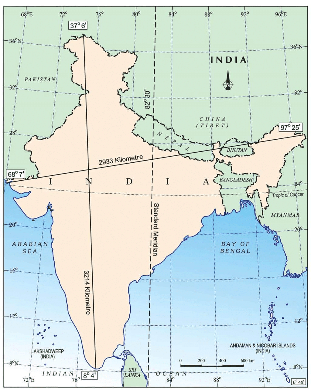 Latitudinal and Longitudinal Extent of India
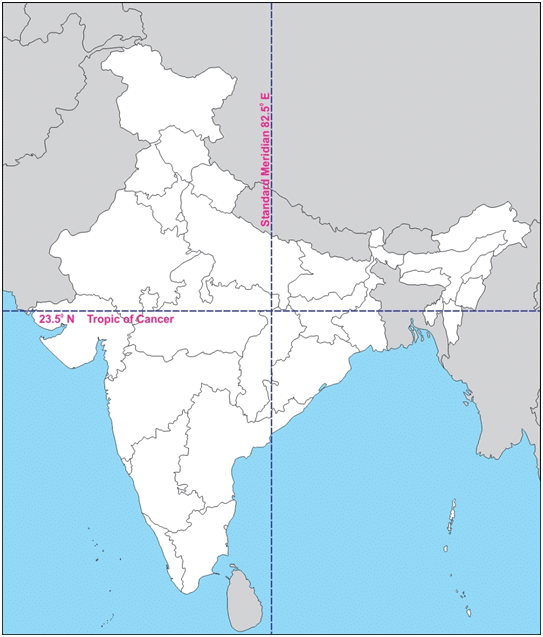
 - The Tropic of Cancer (23°30' N) nearly divides the country into two equal parts. Southeast of the mainland are the Andaman and Nicobar Islands in the Bay of Bengal, while to the southwest lie the Lakshadweep Islands in the Arabian Sea.
Size of India
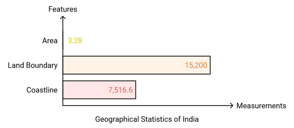
India covers an area of 3.28 million square kilometers, which constitutes about 2.4% of the world’s total land area. It is the seventh-largest country in the world.
- Land Boundary: Approximately 15,200 kilometers.
- Coastline: The total length of the coastline, including the Andaman & Nicobar Islands and Lakshadweep, is 7,516.6 kilometers.
Northern Boundary: India is bordered by young fold mountains to the northwest, north, and northeast.
Southern Boundary: Below about 22° north latitude, India narrows and extends towards the Indian Ocean, splitting it into two seas: the Arabian Sea to the west and the Bay of Bengal to the east.
North-South Extent of India: The north-south extent of India is larger than its east-west extent even though the country’s latitudinal and longitudinal extent in degrees is of the same value.
Impact of India's Geographic Extent
Longitudinal Impact: India spans about 30° of longitude, resulting in a two-hour time difference from Gujarat in the west to Arunachal Pradesh in the east. To standardize time across the country, India uses the Standard Meridian (82°30'E) passing through Mirzapur in Uttar Pradesh. This meridian ensures a uniform time reference for the entire country.
Latitudinal Impact: The latitudinal extent of India affects the duration of day and night. In Kanyakumari, near the Equator, day and night lengths are nearly equal with only a 45-minute difference. However, as you move northward, this difference increases significantly, reaching up to 5 hours in northern Kashmir.
India and the World
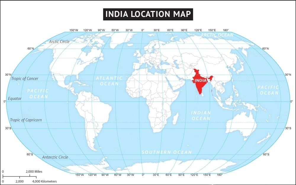
India's proximity to densely populated regions such as China, Japan, and Southeast Asia has significantly contributed to fostering strong trade ties and cultural relations with these nations.
 India on World Map
India's location offers several strategic advantages:
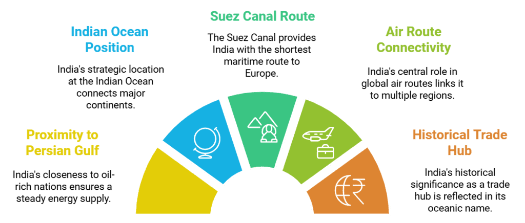
Proximity to Oil-Rich Persian Gulf: India is located near the oil-rich countries of the Persian Gulf, from which it receives the majority of its energy supplies.
Strategic Position in the Indian Ocean: Situated at the head of the Indian Ocean, India enjoys a commercially advantageous location, connecting Africa, Asia, and Australia.
Suez Sea Route: The Suez Canal provides India with the shortest sea route to industrialized Europe and the Americas, further boosting trade.
Air Route Connectivity: India's central position in global air routes connects it to Europe and America on one side, and East Asia, Southeast Asia, and Australia on the other.
Indian Ocean's Name: The third-largest ocean is named the Indian Ocean, highlighting India's dominant position at its head. Historically, India was a preferred destination for global traders.
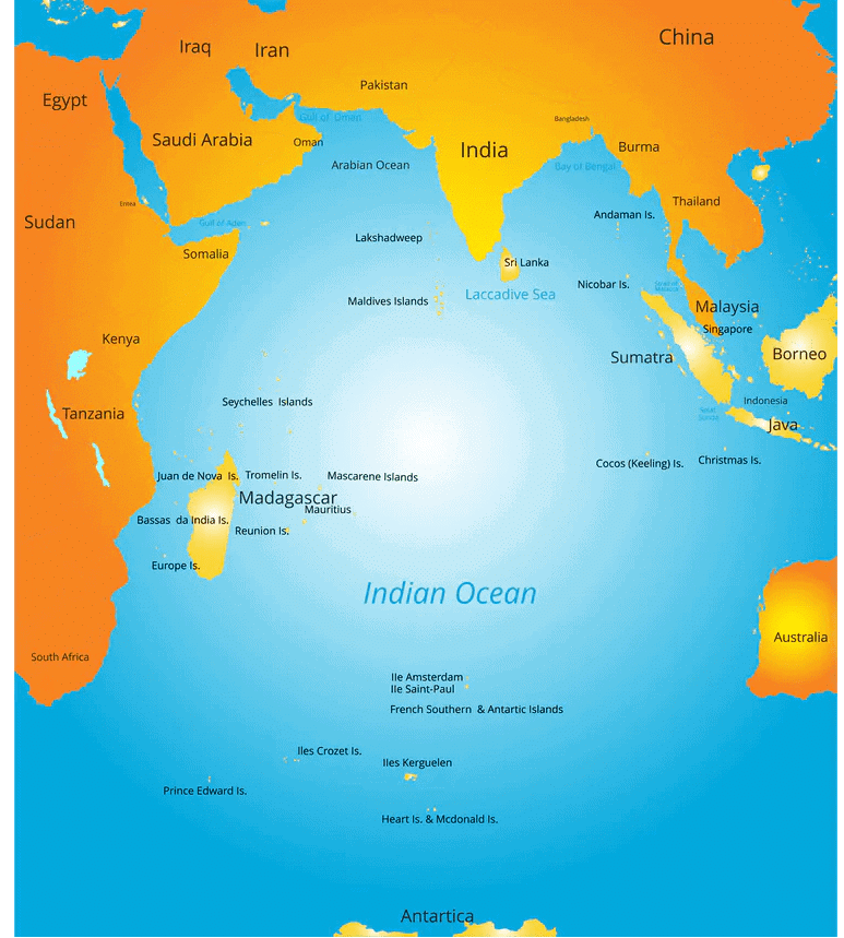 Indian Ocean
India’s Contacts with the Outside World in Ancient and Medieval Times
India’s location at the head of the Indian Ocean enabled it to establish maritime routes to East Africa, West Asia, South and Southeast Asia, and East Asia, fostering close cultural and commercial relationships.
Historical Exchanges:
- Ideas and Commodities: India has a long history of exchanging ideas and goods. Ancient texts like the Upanishads, the Ramayana, and the Panchatantra, as well as innovations such as Indian numerals and the decimal system, spread across the world.
- Goods and Trade: Indian spices, muslin, and other goods were traded widely, influencing global markets.
- Cultural Influences: Greek sculpture and architectural styles, such as domes and minarets from West Asia, have left a mark on Indian art and architecture.
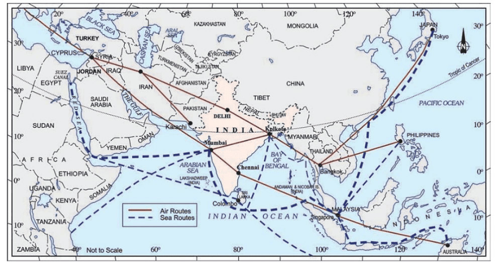 India on International highway of trade and commerce
India's Neighbours
- To the north of India are China, Nepal, and Bhutan, and to the east, Bangladesh and Myanmar, to the west and northwest are Pakistan and Afghanistan.
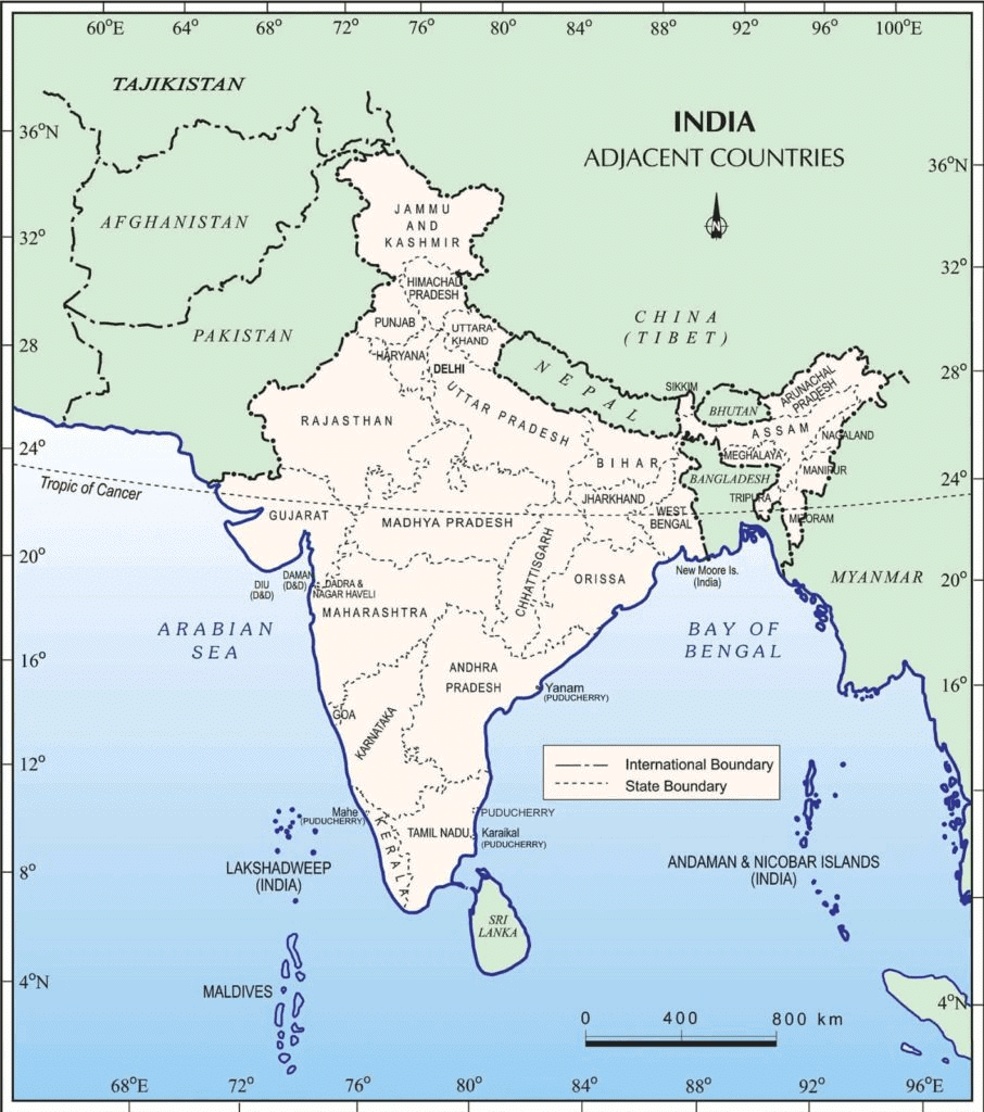 India and Its Neighbouring Countries
 - In the south, separated from India by the Palk Strait, lies the island country of Sri Lanka.
- To the south of Lakshadweep lies the Maldives, not far from the Andaman and Nicobar islands lie our closest South-East Asian neighbors: Indonesia, Malaysia, and Thailand.
The Indian Subcontinent
India is called a subcontinent because of its vastness and distinct physical and cultural identity. The countries that form the Indian subcontinent are Pakistan in the northwest, India at the core, Nepal in the north, Bhutan in the northeast, and Bangladesh in the east.
Some Interesting Knowledge
(i) The southernmost point of the Indian Union – ‘Indira Point’ got submerged under the sea water in 2004 during the Tsunami.
(ii) Since the opening of the Suez Canal in 1869, India’s distance from Europe has been reduced by 7000 km.
(iii) Before 1947, there were two types of states in India – the provinces and the princely states. Provinces were ruled directly by British officials who were appointed by the Viceroy.Princely states were ruled by local, hereditary rulers, who acknowledged sovereignty in return for local autonomy.
Watch the video below for detailed explanation:
Key Terms
Standard Meridian: A meridian that is used as a reference line from which time zones are calculated. In India, the Standard Meridian is 82°30' E, which passes through Mirzapur in Uttar Pradesh.
Latitudinal and Longitudinal Extent: These refer to the measurements in degrees of latitude and longitude that define the borders of a geographic area or country. For India, it ranges from 8°4' N to 37°6' N latitude and from 68°7' E to 97°25' E longitude.
Tropic of Cancer: A circle of latitude located at approximately 23°30' N, marking the most northerly position at which the sun may appear directly overhead at noon. It divides India into almost two equal parts.
Suez Canal: An artificial sea-level waterway in Egypt, connecting the Mediterranean Sea to the Red Sea through the Isthmus of Suez. It opened in 1869 and significantly reduces the maritime journey between Europe and South, Southeast, and East Asia.
Decimal System: A positional numeral system using the base ten. It is the standard system for denoting integer and non-integer numbers. It is important to note that the concept of zero and the place-value system were developed in India.
Indira Point: The southernmost point of the Indian Union, located in the Nicobar Islands, which was submerged underwater after the 2004 Tsunami.
Palk Strait: A strait between the Tamil Nadu state of India and the Jaffna District of the Northern Province of the island nation of Sri Lanka.
Princely States: Various territories within India during the British Empire that were not directly governed by the British, but rather by their own local rulers under a form of indirect rule.
Provinces: In the context of British India, these were regions administered directly by a British governor on behalf of the British crown.
Subcontinent: A subcontinent is a large, distinct landmass that is smaller than a continent but still significant in size and cultural identity. It often has unique geographical features and is characterized by its own cultural, historical, and social aspects. An example of a subcontinent is South Asia, which includes countries like India, Pakistan, and Bangladesh.
|
55 videos|525 docs|78 tests
|
FAQs on Class 9 Geography Chapter 1 Notes - India: Size and Location
| 1. What is the geographical location of India in relation to the equator and the tropics? |  |
| 2. What is the total area of India and how does it rank globally in terms of size? | |
| 3. Which countries share a border with India and how does this impact its relations with neighbors? | |
| 4. How does India's location contribute to its climate diversity? | |
| 5. What are some key terms associated with India's size and location that are important for understanding the geography of the country? | |


Free
,practice quizzes
,ppt
,Important questions
,past year papers
,Class 9 Geography Chapter 1 Notes - India: Size and Location
,video lectures
,Summary
,Class 9 Geography Chapter 1 Notes - India: Size and Location
,Semester Notes
,Viva Questions
,shortcuts and tricks
,Exam
,Previous Year Questions with Solutions
,Objective type Questions
,Class 9 Geography Chapter 1 Notes - India: Size and Location
,Sample Paper
,study material
,mock tests for examination
,MCQs
,Extra Questions
;


Detailed Chapter Notes: India - Size And Location Free PDF Download
Importance of Detailed Chapter Notes: India - Size And Location
Detailed Chapter Notes: India - Size And Location
Detailed Chapter Notes: India - Size And Location Class 9 Questions
Study Detailed Chapter Notes: India - Size And Location on the App
|
© EduRev
|
Education Revolution
|


|


