GPSC (Gujarat) Exam > GPSC (Gujarat) Notes > Gujarat State PSC (GPSC) Preparation: All subjects > Gujarat: Transport Network
Gujarat: Transport Network | Gujarat State PSC (GPSC) Preparation: All subjects - GPSC (Gujarat) PDF Download
| Table of contents |

|
| Introduction |

|
| Road Infrastructure |

|
| Bridges in Gujarat |

|
| Railways in Gujarat |

|
| Airports in Gujarat |

|
| Waterways in Gujarat |

|
Introduction
- Gujarat boasts an extensive transportation network comprising various types of roads. This network includes national highways, state highways, district highways, district roads, and rural roads.
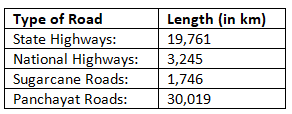
- Gujarat features over 300 state highways, covering a total distance of 19,761 kilometers, along with 13 national highways spanning 3,245 kilometers.

Road Infrastructure
- One of the most extensive and comprehensive road networks in India is located in the state of Gujarat. Currently, Gujarat has a total road length of approximately 74,500 kilometers, which can be broadly categorized into a core and a non-core network. The core network consists of national highways and around 6,000 kilometers of state highways, while the non-core network includes other state highways, major district roads, other district roads, and village roads.
- When examining road density in Gujarat, it is observed to be approximately 38 kilometers per 100 square kilometers and 146 kilometers per lakh of population. These figures are comparable to the national average for India, which is 43 kilometers per 100 square kilometers and 126 kilometers per lakh of population. To address the need for improvement and maintenance of the core network, the state government has launched an ambitious 6,000-kilometer State Highway Development Program (SHDP). Additionally, to boost road connectivity between the Dedicated Freight Corridor (DFC) and Delhi-Mumbai Industrial Corridor (DMIC) areas with ports and other growth centers, an arterial network has been identified.
- The passage of the Golden Quadrilateral and the North-South and East-West corridors of the National Highway Development Program (NHDP) through Gujarat has significantly enhanced the national highway network in the state. Furthermore, the relatively better quality of the national highways in Gujarat, compared to other regions of the country, can be attributed to factors such as the successful implementation of Public-Private Partnership (PPP) roads, expressways, six-lane projects under advanced phases of the NHDP, judicious use of external funding, and a relatively better maintenance regime. Various network improvement schemes, including the World Bank-funded roads, Pragati Path, Kisan Path, and Vikas Path road development programs, have been effectively executed by the state. These initiatives have led to substantial improvements in key stretches of state highways, providing a satisfactory driving experience.
- A key challenge for the core network is to meet the growing demands of emerging growth centers, such as industrial parks, ports, Special Economic Zones (SEZs), Special Investment Regions (SIRs), and urban centers that will shape Gujarat's economic landscape. Ensuring the continued development of high-quality roads with sufficient capacity is crucial for facilitating trade and enhancing competitiveness. Achieving this will require the implementation of output-focused delivery systems to maintain an excellent road network.
- Gujarat was the first state in India to enact a law governing Build, Own, and Transfer (BOT) transactions and other related measures, which, along with private participation in infrastructure, have played a significant role in the state's road development. It is noteworthy that the transport sector in Gujarat accounts for nearly 17.05% of the total planned investments, amounting to Rs. 39,110 crores, for the period up to 2020 as outlined in the "Blueprint for Infrastructure in Gujarat - Vision 2020" prepared by GIDB.
Category of Roads in Gujarat
The roads in Gujarat and their extent/distance may be categorized as below:
- The total length of roads in the state, excluding Non-plan, Community, Urban, and Project roads, increased from 78,558 kilometers at the end of 2012-13 to 79,894 kilometers at the end of 2013-14. Of this total road length in 2013-14, 77,864 kilometers (97.46 percent) were surfaced roads, while 2,030 kilometers (2.54 percent) were unsurfaced.
- At the end of 2013-14, the 79,894 kilometers of roads included 4,023 kilometers of National Highways, 18,017 kilometers of State Highways, 20,472 kilometers of Major District Roads, 10,213 kilometers of Other District Roads, and 27,169 kilometers of Village Roads.
- The length of National Highways increased as some State Highways were reclassified as National Highways. The total road length, equivalent to the length of a Standard Single Lane (SSL) (SSL = 3.75 meters), was 98,965 kilometers in 2012-13. Due to road widening in 2013-14, this equivalent length increased to 103,005 kilometers.
Safety Policy – 2016
- To ensure the fitness of commercial vehicles in the state, the development of "Computerized Fitness Centres" is currently underway in Ahmedabad, Kutch (Bhuj), Rajkot, and Vadodara.
- The number of registered motor vehicles in the state saw an increase from 187.20 lakh in 2014-15 to 203.61 lakh in 2015-16, reflecting a growth of 8.76% during the year. Specifically, the number of registered motorcycles, scooters, and mopeds rose from 137.05 lakh to 149.19 lakh. In the three- and four-wheeler category, the number of auto-rickshaws increased from 6.78 lakh to 7.18 lakh, motor cars (including Jeeps) grew from 21.89 lakh to 24.44 lakh, goods vehicles (including tempos) increased from 9.42 lakh to 10.09 lakh, trailers saw a rise from 3.54 lakh to 3.69 lakh, and tractors increased from 6.10 lakh to 6.41 lakh compared to the previous year.
Gujarat State Road Transport Corporation
- The number of routes operated by the Corporation increased from 14,706 at the end of 2014-15 to 15,353 by the end of 2015-16. The route kilometers coverage also saw an increase, going from 11.91 lakh kilometers in 2014-15 to 12.22 lakh kilometers in 2015-16.
- However, the average number of vehicles on the road during 2015-16 was 6,587, slightly down from 6,683 in 2014-15. Despite this, the total effective kilometers covered by the Corporation increased from 10,557.66 lakh at the end of 2014-15 to 10,665.37 lakh at the end of 2015-16. The average daily vehicle utilization also improved, rising from 438 kilometers at the end of 2014-15 to 448 kilometers at the end of 2015-16.
- The average number of passengers traveling per day saw a slight decrease, dropping from 21.19 lakh in 2014-15 to 20.80 lakh in 2015-16. Correspondingly, the Corporation's gross earnings decreased from Rs. 2,862.18 crore in 2014-15 (tentative) to Rs. 2,566.96 crore in 2015-16 (tentative).
Question for Gujarat: Transport NetworkTry yourself: Which state in India boasts one of the most extensive and comprehensive road networks?View Solution
Bridges in Gujarat
Ellis Bridge
- Located in Ahmedabad, Gujarat, the Ellis Bridge is a century-old heritage structure spanning the Sabarmati River. Constructed in 1892, this bowstring arch truss bridge holds the distinction of being Ahmedabad's first bridge. In 1997, new concrete extensions were added on either side of the original bridge, and it was renamed Swami Vivekananda Bridge. Despite the official name change, locals still commonly refer to it as Ellis Bridge.
- This iconic landmark, representing Ahmedabad's historical legacy, has featured in films such as Kai Po Che! (2013) and Kevi Rite Jaish (2012). Notably, at the western end of the bridge lies the Karnavati Art Gallery, which frequently hosts art exhibitions.
Golden Bridge
- In 1881, the British constructed the Golden Bridge, also known as the Narmada Bridge, to span the Narmada River. This bridge was built to improve access for trade and official administration between Ankleshwar and Bharuch, facilitating better connections to Bombay (now Mumbai).
- The Golden Bridge has withstood numerous floods and natural disasters, including earthquakes, over its 129-year history. Remarkably, it continues to serve as a vital transportation link for the residents of Ankleshwar and Bharuch. The bridge is an integral part of Bharuch's rich history, akin to the city's archaeological and architectural heritage, which includes many ancient temples.
Nehru Bridge
- The Nehru Bridge is a major artery for public transportation in Ahmedabad, running over the Sabarmati River. Named after India's first Prime Minister, Jawaharlal Nehru, this bridge is modern, more advanced, and larger compared to the historic Ellis Bridge.
- One of Ahmedabad's attractions, the Patang Revolving Restaurant, is located near the Nehru Bridge on the banks of the Sabarmati River.
Subhash Bridge
- Subhash Bridge holds significance in Ahmedabad due to its proximity to the Gandhi Ashram, a site closely associated with Mahatma Gandhi. Located just 1.5 kilometers away from the bridge, the Gandhi Ashram Shopping Area is well-known for its collection of Khadi products.
- Subhash Bridge is also a prominent residential area in Ahmedabad, with over 80 residential societies. The area is geographically separated from the rest of the city by a railway line to the west and the Sabarmati River to the east.
Railways in Gujarat
- The Western Railways, a division of Indian Railways, oversees the state of Gujarat. Major railway stations within the state include Ahmedabad, Surat, Vadodara, and Rajkot. Indian Railways is considering establishing a Delhi-Mumbai route passing through Gujarat, as well as a proposed Pune-Mumbai-Ahmedabad High-Speed Passenger Corridor, which would cover the states of Maharashtra and Gujarat. The Vadodara Railway Station, the busiest junction in Gujarat, is the fourth busiest in the entire country, connecting Delhi and Mumbai via the Western Railway Mainline.
- Gujarat's railway system provides a fast, economical, and efficient means of transportation for both goods and passengers, connecting major cities in the state to metropolitan areas across India. The major rail routes in Gujarat are classified into Broad Gauge (BG), Meter Gauge (MG), and Narrow Gauge (NG) lines.
Major Railway Stations in Gujarat
Ahmedabad Railway Station
- The Ahmedabad Railway Station is Gujarat's main and busiest railway station, and it is also the second-highest income-generating division in the Western Railways, after Mumbai. A new initiative at this station is the introduction of a hand-push luggage trolley service, typically found only at airports.
- Initially, the service is available only on platform no. 1 for a fee of Rs. 5 per luggage trolley. Once new elevators and escalators are operational, the trolley service will be extended to all platforms.
Anand Railway Station
- Anand Railway Station, a major junction in Anand, Gujarat, was established in 1901, connecting Ahmedabad with Vadodara and Mumbai. In 1929, a 14-mile-long Broad Gauge line was introduced, connecting Vadtai with Anand and Boriavi, benefiting pilgrims visiting the Swaminarayan Temple in Vadtai.
- Anand is also linked to Godhra and Cambay through other Broad Gauge branches. In 2011, Indian Railways announced plans to develop a "multi-function complex" with budget hotels at the Anand Railway Station.
Rajkot Railway Station
- Rajkot's main railway station, known as Rajkot Junction, is a key terminus for rail transport in the city and is under the jurisdiction of the Western Railways. Rajkot Railway Station is located on the Ahmedabad-Hepa Broad Gauge line and is connected to the Viramgam-Okha rail route.
- It serves as a junction for the Somnath-Viramgam and Okha-Rajkot branch lines. The station is equipped with enquiry counters, reservation halls, tea stalls, and ATMs, and it is undergoing comprehensive automation and infrastructure development, including the addition of a cybercafe, vending machines, a cafeteria, and more. The Rajkot-Viramgam route is also being doubled, with plans to electrify the route in the near future.
Surat Railway Station
- Surat, Gujarat's second-largest city, is served by the Surat Railway Station, among others, including Gotahngam, Kosad, Uttran, Udhna Junction, Bhestan, Niol, and Sachin Railway Stations. Surat Railway Station is the second-highest income-generating station in the Mumbai Division of Western Railways, after Mumbai.
- It is located on the Ahmedabad-Vadodara-Mumbai rail route and connects Surat to major cities across India. The station is equipped with the Advance Railway Ticketing System and a Voice Response System (VRS) for unreserved ticketing. Facilities at the station include ATMs, a 24/7 Food Express Restaurant, and a nearby City Bus Terminal.
Vadodara Railway Station
- Vadodara Railway Station is the busiest in Gujarat and one of the busiest in India. It is a major stop on the Western Railway zone, with two main lines: one connecting Ahmedabad and Mumbai and another connecting Ahmedabad and New Delhi via Kota, Ratlam, and Mathura.
- Vadodara is home to one of the largest electric loco sheds of Western Railways, housing over 130 locomotives. The station also has facilities for AC/DC locomotive change for trains heading towards New Delhi or Mumbai. Vadodara's MEMU car shed serves multiple units that provide feeder services to nearby cities.
Other Railway Stations in Gujarat
- Maninagar Railway Station
- Sabarmati Junction Railway Station
- Derol Railway Station
- Jetalsar Railway Station
- Bajva Railway Station
- Nandesari Railway Station
As of March 31, 2015, the total length of railway lines in Gujarat was 5,258.49 route kilometers, comprising 3,506.55 kilometers of Broad Gauge (BG), 1,193.04 kilometers of Meter Gauge (MG), and 558.90 kilometers of Narrow Gauge (NG) lines.
Airports in Gujarat
- The state of Gujarat has a total of 17 airports. Of these, 9 are under the operational jurisdiction of the Airport Authority of India (AAI), 3 are under the Indian Air Force (IAF) with 2 of them having Civil Terminals, 2 are private airports, and 2 are located in the Union Territory of Daman and Diu, which, though not part of Gujarat, are frequently used by residents of the state.
- Among the 9 AAI-operated airports, Ahmedabad is an International Airport, while the others—Vadodara, Surat, Jamnagar, Rajkot, Bhavnagar, Porbandar, Bhuj, Keshod, Kandla, and Deesa—are domestic airports. Notably, Keshod and Deesa airports currently do not have scheduled flights.
- Additionally, the state government oversees three airstrips located in Mehsana, Amreli, and Mandvi.
- Aircraft movement at both domestic and international airports in Gujarat increased by 20.16 percent in 2015-16 compared to the previous year. Passenger traffic grew from 65.47 lakh in 2014-15 to 81.90 lakh in 2015-16, marking a 25.09 percent increase. Cargo traffic also saw a rise, from 61.70 thousand tonnes in 2014-15 to 70.19 thousand tonnes in 2015-16, an increase of 13.77 percent.
Question for Gujarat: Transport NetworkTry yourself: Which airport in Gujarat is not currently serving scheduled flights?View Solution
Waterways in Gujarat
- Gujarat boasts one of the largest coastlines in India, stretching approximately 1,600 kilometers. Despite the well-developed inland roadways, certain routes, such as from Mandvi in the Kutch region to Okha in Saurashtra, can take over 10 hours by road. In contrast, a ferry service or hovercraft could reduce this travel time to just 1.5 hours, offering a more convenient mode of transportation.
- Under the National Waterway Act, 2016, at least five rivers in Gujarat—including the Mahi, Narmada, Sabarmati, and Tapi rivers, which flow into the Gulf of Khambhat—are being considered for inland water transport. The proposed National Waterways include 436 kilometers on the Tapi River (National Waterway-100) from Hathnur Dam in Maharashtra to the Gulf of Khambhat, 212 kilometers on the Sabarmati River (National Waterway-87) from Sadholiya to the Gulf, 227 kilometers on the Narmada River (National Waterway-73) from Pandhariya near the Gujarat-Maharashtra border, and 248 kilometers on the Mahi River (National Waterway-66) from Kadana Dam to the river’s mouth. A feasibility study is also underway for the Jawai-Luni rivers (National Waterway-48), which originate in the Aravalli ranges in Rajasthan and flow into the marshes of the Rann of Kutch in Gujarat. The length of the waterway in this river system is about 324 kilometers within the Rann of Kutch.
- In October 2017, Prime Minister Narendra Modi inaugurated Phase 1 of the Ro-Ro (Roll on, Roll off) ferry service between Ghogha and Dahej in Gujarat. This marks South Asia's first world-class Ro-Ro ferry service. The project, designed to connect South Gujarat and Saurashtra, will allow vehicles with passengers aboard, thereby reducing travel time, saving fuel, and alleviating road congestion. The distance between the two points will be reduced from 350 kilometers by road to 30 kilometers by sea, cutting travel time from 7-8 hours to just one hour. World-class terminals have been constructed at Ghogha near Bhavnagar and Dahej near Bharuch to support this service.
The document Gujarat: Transport Network | Gujarat State PSC (GPSC) Preparation: All subjects - GPSC (Gujarat) is a part of the GPSC (Gujarat) Course Gujarat State PSC (GPSC) Preparation: All subjects.
All you need of GPSC (Gujarat) at this link: GPSC (Gujarat)
FAQs on Gujarat: Transport Network - Gujarat State PSC (GPSC) Preparation: All subjects - GPSC (Gujarat)
| 1. What is the road density in Gujarat and how does it compare to other states in India? |  |
Ans. The road density in Gujarat is higher than the national average and ranks among the top states in India in terms of road infrastructure.
| 2. What are some of the challenges faced in developing Gujarat's road infrastructure? |  |
Ans. Some of the challenges in developing Gujarat's road infrastructure include land acquisition issues, funding constraints, and environmental concerns.
| 3. How does the vehicle registration data in Gujarat compare to the state's road transport corporation data? |  |
Ans. The vehicle registration data in Gujarat reflects the growing number of vehicles on the roads, while the state road transport corporation data shows the usage of public transportation services.
| 4. What are some of the key features of the public transportation corporation in Gujarat? |  |
Ans. The public transportation corporation in Gujarat operates a wide range of bus services connecting various cities and towns in the state, contributing to the overall transportation network.
| 5. What are some of the notable bridges in Gujarat, and where are they located? |  |
Ans. Some notable bridges in Gujarat include the Golden Bridge, Nehru Bridge, and Subhash Bridge, with locations in different cities like Bharuch, Ahmedabad, and Surat.
Related Searches


