Important Questions: Maps and Locations | Mathematics (Maths Mela) Class 5 - New NCERT PDF Download

A. Look at the map of India below and find the states these children are talking about. Answer the questions:
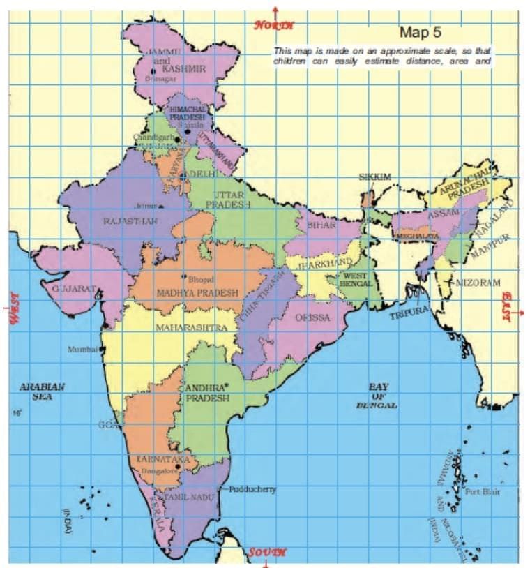
1. The Karnataka team starts from Bangalore and moves in the north direction. Which states does it cross to reach Delhi?
Solution:
Maharashtra, Madhya Pradesh and Rajasthan.
2. Jammu and Kashmir is to the north of Delhi so the team from there travels towards south to reach Delhi. Which states does it cross?
Solution: Himachal Pradesh, Punjab and Haryana.
3. Nonu lives in Gujarat. Nonu’s friend Javed lives in West Bengal. Nonu wants to visit his friend. In which direction will he travel?
a) Towards west b) Towards east c) Towards south d) Towards north
Solution:
b) Towards the east
4. Is there any state which is to the north of Jammu and Kashmir?
Solution:
No, there is no state which is to the north of Jammu and Kashmir.
5. Is there any state which is to the west of Gujarat?
Solution:
No, there is no state which is to the west of Gujarat.
6. If 1 cm on the map shows 200km on the ground, use this scale to find out:
A) About how far is Delhi from Jaipur?
a) 50 km b) 500 km c) 250 km
Solution:
c) 250 km
B) Estimate how far Jaipur is from Bhopal.
On the map = _______ cm.
On the ground = _______ km
Solution:
On the map = 2cm.
On the ground = 400km
7. Look at the map and tell:
a) Which state is surrounded by four other states?
Solution:
Madhya Pradesh
b) Which state has the largest area? If its name is not in the map, find it from your teacher or parents. Explain how you got your answer.
Solution:
Rajasthan. This can be observed from the given map.
c) Which state is about 8 times bigger in area than Sikkim?
i. Uttar Pradesh
ii. Tripura
iii. Maharashtra
iv. Himachal Pradesh
Solution:
iv. Himachal Pradesh
d) About how many times of Punjab is the area of Rajasthan?
Solution:
Rajasthan is about 7 times the area of Punjab.
B. Trip to Red Fort: Answer the questions using map below.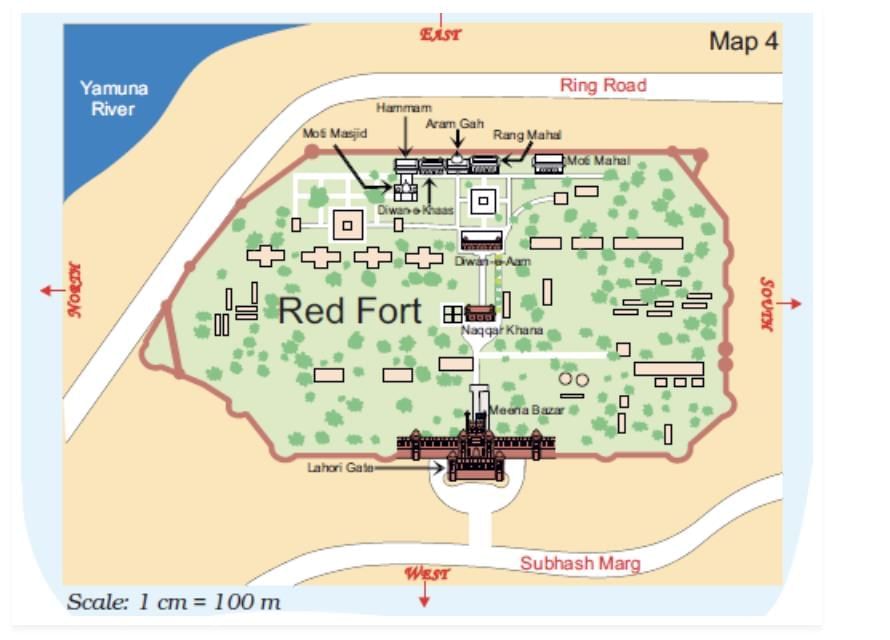
1. Which of these is nearer to river Yamuna? — The Diwan-e-Aam or the Diwan-e-Khaas?
Solution:
Diwan-e-Khaas is nearer to river Yamuna than Diwan-e-Aam.
2. Between which two buildings is Aaram Gah?
Solution:
Aaram Gah is between Diwan-e-Khaas and Rang Mahal.
3. Which buildings do you pass while going from Rang Mahal to the Hammam?
Solution:
We will pass through Aram Gah and Diwan-e-Khaas while going from Rang Mahal to the Hammam.
4. Which building on this map is farthest from Meena Bazar?
Solution:
Hammam is farthest from Meena Bazar.
5. About how far is Lahori Gate from Diwan-e-Khaas?
Solution:
The map distance of Lahori Gate from Diwan-e-Khaas is about 6 cm.
We know 1 cm = 100 m
So, the ground distance of Lahori Gate from Diwan-e-Khaas = 6 ×100 = 600 m
Make it bigger, make it smaller:
C. If we zoom in to look more closely at one part of the map, it looks like this.
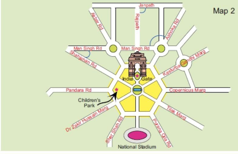 Find out from the map:
1. If you are walking on Rajpath then after India Gate on which side would Children’s Park be?
Solution:
The Children’s Park would be on the right side, while walking on Rajpath.
2. Which of these roads make the biggest angle between them?
(a) Man Singh Road and Shahjahan Road
(b) Ashoka Road and Man Singh Road (the angle away from India Gate)
(c) Janpath and Rajpath
Solution:
(b) Ashoka Road and Man Singh Road
3. Which of the above pairs of roads cut at right angles?
Solution:
Janpath and Rajpath cut at right angles.
|
35 videos|276 docs|7 tests
|
FAQs on Important Questions: Maps and Locations - Mathematics (Maths Mela) Class 5 - New NCERT
| 1. What are the different types of maps used for studying locations? |  |
| 2. How can maps help us understand geography better? | |
| 3. What is the significance of scale in maps? | |
| 4. How do symbols and legends on maps work? | |
| 5. Why is it important to learn about maps and locations in class? | |


shortcuts and tricks
,study material
,Exam
,ppt
,practice quizzes
,Extra Questions
,Important questions
,mock tests for examination
,Important Questions: Maps and Locations | Mathematics (Maths Mela) Class 5 - New NCERT
,Semester Notes
,Viva Questions
,Important Questions: Maps and Locations | Mathematics (Maths Mela) Class 5 - New NCERT
,MCQs
,Previous Year Questions with Solutions
,Objective type Questions
,Important Questions: Maps and Locations | Mathematics (Maths Mela) Class 5 - New NCERT
,Summary
,Sample Paper
,past year papers
,video lectures
,Free
;


Important Questions: Maps and Locations Free PDF Download
Importance of Important Questions: Maps and Locations
Important Questions: Maps and Locations Notes
Important Questions: Maps and Locations Class 5
Study Important Questions: Maps and Locations on the App
|
© EduRev
|
Education Revolution
|


|


within 7 days!