Class 9 Exam > Class 9 Notes > Chapter Notes For Class 9 > Key Concepts - Drainage
Key Concepts - Drainage | Chapter Notes For Class 9 PDF Download
| Table of contents |
|
| What is Drainage? |
|
| The Himalayan Rivers |
|
| The Peninsular Rivers |
|
| Lakes |
|
| Role of Rivers in the Economy |
|

What is Drainage?
‘Drainage’ is a term signifying the river system of an area.
- Drainage refers to the system through which water is collected and drained in a particular area.
- A drainage basin is the land area that is drained by a single river and its tributaries. It is also known as a river basin.
- A water divide is an upland or ridge that separates two adjacent drainage systems.
- Rivers in India can be classified into three major types based on their origin: Himalayan, Peninsular, and Coastal rivers.
- Himalayan rivers are fed by rain and snow, making them perennial, or having water throughout the year. These rivers are known for creating various landforms such as meanders, oxbow lakes, and other depositional features along their banks.
- Peninsular rivers are seasonal and rely mainly on rainfall. Most of these rivers originate in the Western Ghats and flow towards the Bay of Bengal.
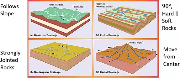
Question for Key Concepts - DrainageTry yourself:Which one of the following describes the drainage patterns resembling the branches of a tree?
View Solution
The Himalayan Rivers
- A river system, particularly in the context of the Himalayan rivers, comprises the main river and its tributaries.
- The principal Himalayan rivers are the Indus, the Ganga, and the Brahmaputra.
The Indus River System
- The Indus River originates near Lake Mansarovar in Tibet and enters India in the Ladakh district of Jammu and Kashmir.
- Its tributaries include the Satluj, Beas, Ravi, Chenab, and Jhelum, which merge with the Indus at various points along its course.
- The Indus River stretches a total length of 2900 km, making it one of the longest rivers in the world. It empties into the Arabian Sea, just east of Karachi.
The Ganga River System
- Bhagirathi is the name given to the source of the Ganga River.
- The Gangotri Glacier feeds into the Bhagirathi, which then combines with the Alaknanda River at a place called Devprayag. This confluence marks the beginning of the Ganga River.
- The Ganga River receives several small rivers, known as tributaries, from the Himalayas. Some of these tributaries include the Ghaghara, Gandak, and Kosi rivers.
- One of the major tributaries of the Ganga is the Yamuna River, which originates from the Yamunotri Glacier in the Himalayas. The Yamuna River joins the Ganga River at Allahabad.
- Other tributaries, such as the Chambal, Betwa, and Son rivers, flow from the Peninsular uplands and merge with the Ganga River.
- The Ganga River flows into the Bay of Bengal. The Brahmaputra River, while connecting to the Ganga's delta, is part of a different river system.
- The delta formed by the confluence of the Ganga and Brahmaputra Rivers as they enter the Bay of Bengal is known as the Sunderban Delta.
- The Ganga River is over 2500 km long and features many bends and curves along its course before reaching the Bay of Bengal.
The Brahmaputra River System
- The Brahmaputra River System has its origin in Tibet, close to the sources of the Indus and Satluj rivers. It enters India through Arunachal Pradesh and flows through Assam, where it is joined by several tributaries.
- The main tributaries that join the Brahmaputra include the Lohit, Dibang, and Teesta rivers.
- In Assam, the Brahmaputra features a braided channel, which creates numerous river islands along its length.
- Unlike other rivers in northern India, the Brahmaputra has significant deposits of silt on its bed. These silt deposits contribute to the formation of river islands and can change the river's course over time.
The Peninsular Rivers
- Peninsular rivers in India exhibit unique drainage patterns that significantly impact the region's geography and ecology.
- The major rivers of the peninsula, including the Mahanadi, Godavari, Krishna, and Kaveri, flow eastward into the Bay of Bengal.
- In contrast, the Tapi and Narmada rivers are the only ones flowing westward, creating estuaries that drain into the Arabian Sea.
- The drainage basins of these rivers are relatively small in size.
The Godavari Basin
- The Godavari River, originating in the Nasik district of Maharashtra, is the largest river in the peninsular region.
- Its vast basin encompasses most of Maharashtra, Madhya Pradesh, Odisha, Andhra Pradesh, and parts of Chhattisgarh.
- Key tributaries of the Godavari include the Purna, Wardha, Pranhita, Manjra, Wanganga, and Penganga rivers.
- Due to its length and the extensive area it covers, the Godavari is often referred to as the Dakshin Ganga (Southern Ganges).
- The Godavari River ultimately empties into the Bay of Bengal.
The Mahanadi Basin
- The Mahanadi River is 860 kilometers long, originating in Chhattisgarh and flowing through Odisha before emptying into the Bay of Bengal.
- The basin of the Mahanadi River spans across the states of Chhattisgarh, Odisha, and Jharkhand.
The Krishna Basin
- The Krishna River stretches for 1,400 kilometers, beginning from a spring near Mahabaleshwar and flowing towards the Bay of Bengal.
- Its main tributaries are the Bhima, Musi, Ghatprabha, Koyana, and Tungabhadra rivers. The Krishna Basin is shared by the states of Maharashtra, Karnataka, and Andhra Pradesh.
The Narmada Basin
- The Narmada River starts its journey in the Amarkantak hills and flows through a rift valley, which is a crucial aspect of its formation as per the NCERT textbook. During its course, it carves a gorge through the marble rocks in Madhya Pradesh.
- The main rivers that flow towards the west are the Sabarmati and Mahi.
The Tapi Basin
- Originating in Betul, Madhya Pradesh, Tapi flows through a basin that covers Madhya Pradesh, Gujarat and Maharashtra.
- The main west-flowing rivers are Sabarmati, Mahi, Bharatpuzha and Periyar.
The Kaveri Basin
Originating in the Brahmagiri range of the Western Ghats, the Kaveri reaches the Bay of Bengal at Kaveripatnam, sharing its basin with Karnataka, Tamil Nadu and Kerala.
Question for Key Concepts - DrainageTry yourself:The drainage basin of the Mahanadi is not shared by
View Solution
Lakes
- Permanent vs. Seasonal Lakes: Most lakes are permanent, but some only have water during the rainy season.
- Formation of Lakes:
- Glacial Lakes: These lakes form when glaciers carve out a basin that fills with melted snow.
- Tectonic Activity: Some lakes, like Wular Lake in Jammu and Kashmir, are created by tectonic movements.
- Damming Rivers: In addition to natural lakes, damming rivers for hydropower has led to the creation of lakes.
- Oxbow Lakes:. river winding through a floodplain can create cut-offs, which later turn into oxbow lakes.
- Role of Lakes: Lakes play a vital role in regulating river flow, preventing flooding, generating hydropower, moderating climate, maintaining aquatic ecosystems, enhancing natural beauty, boosting tourism, and providing recreational opportunities.
Role of Rivers in the Economy
- Rivers are a natural source of water.
- Settlements along riverbanks have evolved into cities over time.
- Rivers are crucial for irrigation, navigation, hydro-power generation, and are vital for various sectors, including agriculture and other economic activities.
River Pollution
- The quality of river water is degraded due to increasing demands from domestic, municipal, industrial, and agricultural sources.
- A large amount of untreated sewage and industrial waste is being dumped into rivers, affecting their natural self-cleaning ability.
- Concerns about the rising pollution levels in rivers have led to the initiation of various action plans aimed at cleaning them.
The document Key Concepts - Drainage | Chapter Notes For Class 9 is a part of the Class 9 Course Chapter Notes For Class 9.
All you need of Class 9 at this link: Class 9
FAQs on Key Concepts - Drainage - Chapter Notes For Class 9
| 1. What is the importance of drainage systems? |  |
Ans. Drainage systems are important because they help in the removal of excess water from the surface of the earth. This excess water can cause flooding, erosion, and landslides. Proper drainage systems ensure that the water is directed away from human settlements, agricultural fields, and other important areas, thereby preventing damage and ensuring safety.
| 2. What are the main rivers in the Himalayan region? | |
Ans. The main rivers in the Himalayan region are the Indus, Ganges, and Brahmaputra. These rivers originate from the glaciers in the Himalayas and flow through India, Nepal, Bangladesh, and Pakistan. They are a source of water for irrigation, hydropower generation, and transportation.
| 3. How are peninsular rivers different from Himalayan rivers? | |
Ans. The peninsular rivers are different from Himalayan rivers in several ways. The peninsular rivers are shorter and have a smaller drainage basin compared to Himalayan rivers. They are also less prone to flooding and erosion. Peninsular rivers such as the Godavari, Krishna, and Cauvery flow through the Deccan Plateau and are a source of water for irrigation, hydropower generation, and drinking water supply.
| 4. What is the role of lakes in the ecosystem? | |
Ans. Lakes play an important role in the ecosystem. They provide habitat for aquatic plants and animals and are a source of water for irrigation, drinking, and recreation. They also help in regulating the water cycle by storing and releasing water during dry spells and heavy rainfall. Lakes can also act as carbon sinks, helping to mitigate the effects of climate change.
| 5. How do rivers contribute to the economy? | |
Ans. Rivers contribute to the economy in several ways. They provide water for irrigation, which is essential for agriculture. They also provide a source of cheap transportation for goods and people, reducing transportation costs and improving access to markets. Rivers are also a source of hydropower, which is a clean and renewable source of energy. Finally, rivers provide opportunities for recreation, such as boating, fishing, and swimming, which can boost the tourism industry.
About this Document

34.1K Views

4.97/5
Rating

Oct 09, 2025
Last updated
Document Description: Key Concepts - Drainage for Class 9 2025 is part of Chapter Notes For Class 9 preparation.
The notes and questions for Key Concepts - Drainage have been prepared according to the Class 9 exam syllabus. Information about Key Concepts - Drainage covers topics
like What is Drainage?, The Himalayan Rivers, The Peninsular Rivers, Lakes, Role of Rivers in the Economy and Key Concepts - Drainage Example, for Class 9 2025 Exam. Find important definitions, questions, notes, meanings, examples, exercises and tests below for Key Concepts - Drainage.
Introduction of Key Concepts - Drainage in English is available as part of our Chapter Notes For Class 9
for Class 9 & Key Concepts - Drainage in Hindi for Chapter Notes For Class 9 course.
Download more important topics related with notes, lectures and mock test series for Class 9
Exam by signing up for free. Class 9: Key Concepts - Drainage | Chapter Notes For Class 9
Description
Full syllabus notes, lecture & questions for Key Concepts - Drainage | Chapter Notes For Class 9 - Class 9 | Plus excerises question with solution to help you revise complete syllabus for Chapter Notes For Class 9 | Best notes, free PDF download
Information about Key Concepts - Drainage
In this doc you can find the meaning of Key Concepts - Drainage defined & explained in the simplest way possible. Besides explaining types of
Key Concepts - Drainage theory, EduRev gives you an ample number of questions to practice Key Concepts - Drainage tests, examples and also practice Class 9
tests

Related Searches
Key Concepts - Drainage | Chapter Notes For Class 9
,Semester Notes
,shortcuts and tricks
,Key Concepts - Drainage | Chapter Notes For Class 9
,mock tests for examination
,ppt
,Important questions
,Exam
,Previous Year Questions with Solutions
,Objective type Questions
,Viva Questions
,practice quizzes
,past year papers
,Key Concepts - Drainage | Chapter Notes For Class 9
,Free
,video lectures
,study material
,Sample Paper
,MCQs
,Summary
,Extra Questions
;


Additional Information about Key Concepts - Drainage for Class 9 Preparation
Key Concepts - Drainage Free PDF Download
The Key Concepts - Drainage is an invaluable resource that delves deep into the core of the Class 9 exam.
These study notes are curated by experts and cover all the essential topics and concepts, making your preparation more efficient and effective.
With the help of these notes, you can grasp complex subjects quickly, revise important points easily,
and reinforce your understanding of key concepts. The study notes are presented in a concise and easy-to-understand manner,
allowing you to optimize your learning process. Whether you're looking for best-recommended books, sample papers, study material,
or toppers' notes, this PDF has got you covered. Download the Key Concepts - Drainage now and kickstart your journey towards success in the Class 9 exam.
Importance of Key Concepts - Drainage
The importance of Key Concepts - Drainage cannot be overstated, especially for Class 9 aspirants.
This document holds the key to success in the Class 9 exam.
It offers a detailed understanding of the concept, providing invaluable insights into the topic.
By knowing the concepts well in advance, students can plan their preparation effectively.
Utilize this indispensable guide for a well-rounded preparation and achieve your desired results.
Key Concepts - Drainage Notes
Key Concepts - Drainage Notes offer in-depth insights into the specific topic to help you master it with ease.
This comprehensive document covers all aspects related to Key Concepts - Drainage.
It includes detailed information about the exam syllabus, recommended books, and study materials for a well-rounded preparation.
Practice papers and question papers enable you to assess your progress effectively.
Additionally, the paper analysis provides valuable tips for tackling the exam strategically.
Access to Toppers' notes gives you an edge in understanding complex concepts.
Whether you're a beginner or aiming for advanced proficiency, Key Concepts - Drainage Notes on EduRev are your ultimate resource for success.
Key Concepts - Drainage Class 9 Questions
The "Key Concepts - Drainage Class 9 Questions" guide is a valuable resource for all aspiring students preparing for the
Class 9 exam. It focuses on providing a wide range of practice questions to help students gauge
their understanding of the exam topics. These questions cover the entire syllabus, ensuring comprehensive preparation.
The guide includes previous years' question papers for students to familiarize themselves with the exam's format and difficulty level.
Additionally, it offers subject-specific question banks, allowing students to focus on weak areas and improve their performance.
Study Key Concepts - Drainage on the App
Students of Class 9 can study Key Concepts - Drainage alongwith tests & analysis from the EduRev app,
which will help them while preparing for their exam. Apart from the Key Concepts - Drainage,
students can also utilize the EduRev App for other study materials such as previous year question papers, syllabus, important questions, etc.
The EduRev App will make your learning easier as you can access it from anywhere you want.
The content of Key Concepts - Drainage is prepared as per the latest Class 9 syllabus.
|
© EduRev
|
Education Revolution
|


|


Signup to see your scores
go up within 7 days!
Access 1000+ FREE Docs, Videos and Tests
Takes less than 10 seconds to signup