Class 9 Exam > Class 9 Notes > Social Studies (SST) Class 9 > Mind Map: India - Size and Location
Mind Map: India - Size and Location | Social Studies (SST) Class 9 PDF Download

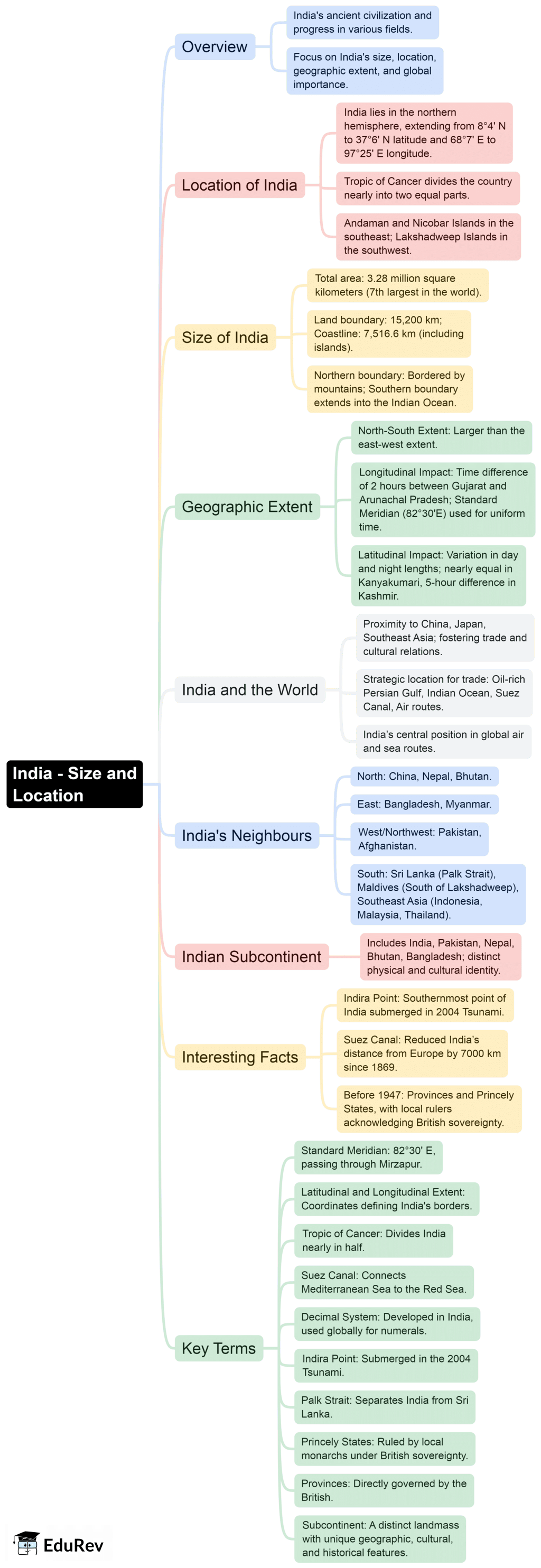
The document Mind Map: India - Size and Location | Social Studies (SST) Class 9 is a part of the Class 9 Course Social Studies (SST) Class 9.
All you need of Class 9 at this link: Class 9
|
55 videos|635 docs|79 tests
|
FAQs on Mind Map: India - Size and Location - Social Studies (SST) Class 9
| 1. What is the geographical size of India in terms of area and population ? |  |
Ans. India is the seventh-largest country in the world, covering an area of approximately 3.287 million square kilometers. As of the latest estimates, India has a population of over 1.4 billion people, making it the second-most populous country globally.
| 2. What are the neighboring countries of India and their significance ? | |
Ans. India shares its borders with several countries, including Pakistan to the northwest, China and Nepal to the north, Bhutan to the northeast, and Bangladesh and Myanmar to the east. These neighboring countries are significant for various reasons, including trade, cultural exchange, and geopolitical relations.
| 3. How does India's location affect its climate and biodiversity ? | |
Ans. India's location, spanning from the Tropic of Cancer in the north to the southern tip of the Indian Peninsula, creates a diverse range of climates, from tropical in the south to temperate in the north. This diversity in climate supports a wide variety of ecosystems and biodiversity, including numerous species of flora and fauna.
| 4. What are the major geographical features of India ? | |
Ans. India is characterized by several major geographical features, including the Himalayas in the north, which serve as a natural barrier, the Indo-Gangetic Plain, the Thar Desert in the northwest, and the Deccan Plateau in the south. Additionally, the country is surrounded by water on three sides, with the Indian Ocean to the south, the Arabian Sea to the west, and the Bay of Bengal to the east.
| 5. How does India's location contribute to its strategic importance in South Asia ? | |
Ans. India's location in South Asia makes it a pivotal player in regional politics and economics. Its proximity to major trade routes, its size, and its military capabilities enhance its influence in the region. Additionally, India's location allows it to engage in diplomatic relations with neighboring countries, making it a crucial player in regional stability and security.
About this Document

2.5K Views

4.85/5
Rating

Sep 04, 2025
Last updated
Document Description: Mind Map: India - Size and Location for Class 9 2025 is part of Social Studies (SST) Class 9 preparation.
The notes and questions for Mind Map: India - Size and Location have been prepared according to the Class 9 exam syllabus. Information about Mind Map: India - Size and Location covers topics
like and Mind Map: India - Size and Location Example, for Class 9 2025 Exam. Find important definitions, questions, notes, meanings, examples, exercises and tests below for Mind Map: India - Size and Location.
Introduction of Mind Map: India - Size and Location in English is available as part of our Social Studies (SST) Class 9
for Class 9 & Mind Map: India - Size and Location in Hindi for Social Studies (SST) Class 9 course.
Download more important topics related with notes, lectures and mock test series for Class 9
Exam by signing up for free. Class 9: Mind Map: India - Size and Location | Social Studies (SST) Class 9
Description
Full syllabus notes, lecture & questions for Mind Map: India - Size and Location | Social Studies (SST) Class 9 - Class 9 | Plus excerises question with solution to help you revise complete syllabus for Social Studies (SST) Class 9 | Best notes, free PDF download
Information about Mind Map: India - Size and Location
In this doc you can find the meaning of Mind Map: India - Size and Location defined & explained in the simplest way possible. Besides explaining types of
Mind Map: India - Size and Location theory, EduRev gives you an ample number of questions to practice Mind Map: India - Size and Location tests, examples and also practice Class 9
tests

Related Searches
Summary
,Mind Map: India - Size and Location | Social Studies (SST) Class 9
,Previous Year Questions with Solutions
,Objective type Questions
,past year papers
,practice quizzes
,Exam
,Semester Notes
,ppt
,Extra Questions
,shortcuts and tricks
,Mind Map: India - Size and Location | Social Studies (SST) Class 9
,MCQs
,Sample Paper
,Mind Map: India - Size and Location | Social Studies (SST) Class 9
,study material
,Free
,Important questions
,video lectures
,mock tests for examination
,Viva Questions
;


Additional Information about Mind Map: India - Size and Location for Class 9 Preparation
Mind Map: India - Size and Location Free PDF Download
The Mind Map: India - Size and Location is an invaluable resource that delves deep into the core of the Class 9 exam.
These study notes are curated by experts and cover all the essential topics and concepts, making your preparation more efficient and effective.
With the help of these notes, you can grasp complex subjects quickly, revise important points easily,
and reinforce your understanding of key concepts. The study notes are presented in a concise and easy-to-understand manner,
allowing you to optimize your learning process. Whether you're looking for best-recommended books, sample papers, study material,
or toppers' notes, this PDF has got you covered. Download the Mind Map: India - Size and Location now and kickstart your journey towards success in the Class 9 exam.
Importance of Mind Map: India - Size and Location
The importance of Mind Map: India - Size and Location cannot be overstated, especially for Class 9 aspirants.
This document holds the key to success in the Class 9 exam.
It offers a detailed understanding of the concept, providing invaluable insights into the topic.
By knowing the concepts well in advance, students can plan their preparation effectively.
Utilize this indispensable guide for a well-rounded preparation and achieve your desired results.
Mind Map: India - Size and Location Notes
Mind Map: India - Size and Location Notes offer in-depth insights into the specific topic to help you master it with ease.
This comprehensive document covers all aspects related to Mind Map: India - Size and Location.
It includes detailed information about the exam syllabus, recommended books, and study materials for a well-rounded preparation.
Practice papers and question papers enable you to assess your progress effectively.
Additionally, the paper analysis provides valuable tips for tackling the exam strategically.
Access to Toppers' notes gives you an edge in understanding complex concepts.
Whether you're a beginner or aiming for advanced proficiency, Mind Map: India - Size and Location Notes on EduRev are your ultimate resource for success.
Mind Map: India - Size and Location Class 9 Questions
The "Mind Map: India - Size and Location Class 9 Questions" guide is a valuable resource for all aspiring students preparing for the
Class 9 exam. It focuses on providing a wide range of practice questions to help students gauge
their understanding of the exam topics. These questions cover the entire syllabus, ensuring comprehensive preparation.
The guide includes previous years' question papers for students to familiarize themselves with the exam's format and difficulty level.
Additionally, it offers subject-specific question banks, allowing students to focus on weak areas and improve their performance.
Study Mind Map: India - Size and Location on the App
Students of Class 9 can study Mind Map: India - Size and Location alongwith tests & analysis from the EduRev app,
which will help them while preparing for their exam. Apart from the Mind Map: India - Size and Location,
students can also utilize the EduRev App for other study materials such as previous year question papers, syllabus, important questions, etc.
The EduRev App will make your learning easier as you can access it from anywhere you want.
The content of Mind Map: India - Size and Location is prepared as per the latest Class 9 syllabus.
|
© EduRev
|
Education Revolution
|


|


Signup to see your scores
go up
within 7 days!
within 7 days!
Takes less than 10 seconds to signup