Monsoons: Indian Geography | Geography for UPSC CSE PDF Download
Introduction
Monsoons are seasonal winds (rhythmic wind movements or Periodic Winds) that reverse their direction with the change of season.
The monsoon is a double system of seasonal winds:
(i) They flow from sea to land during the summer
(ii) They flow from land to sea during winter.
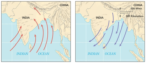 Monsoon- Summer: Sea to Land, Winters: Land to Sea
Some scholars tend to treat the monsoon winds as land and sea breeze on a large scale.
- Monsoons are peculiar to the Indian Subcontinent, South East Asia, Central Western Africa, etc. They are more prominent in the Indian Subcontinent compared to any other region.
Monsoons are like a Heat Engine, which collects, concentrates, stores the sun’s energy of the South Indian Ocean transports it to the great Northern plains, and releases it over the arid landscape.
The monsoons are experienced in the tropical area roughly between 20° N and 20° S.
India receives south-west monsoon winds in summer and north-east monsoon winds in winter.
(i) South-west monsoons are formed due to an intense low-pressure system formed over the Tibetan plateau. It brings intense rainfall to most of the regions in India
(ii) North-east monsoons are associated with high-pressure cells over Tibetan and Siberian plateaus. It brings rain to mainly the south-eastern coast of India (Southern coast of Seemandhra and the coast of Tamil Nadu).Countries like India, Indonesia, Bangladesh, Myanmar, etc., receive most of the annual rainfall during the southwest monsoon season, whereas southeast China, Japan, etc., during northeast rainfall season.
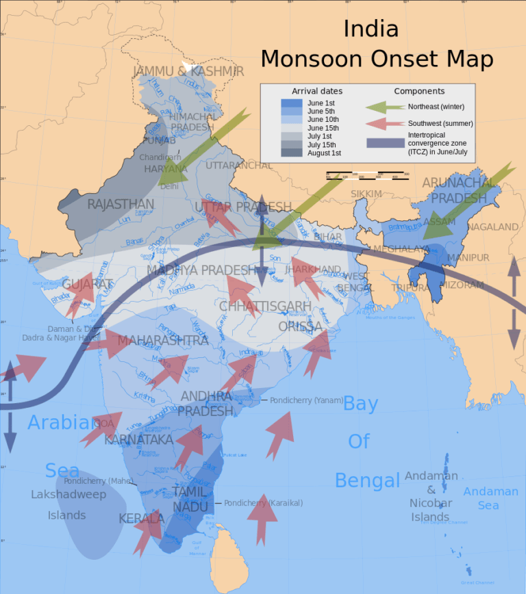
Mechanism of Monsoons
To understand the mechanism of the monsoons, the following facts are important:
(a) The differential heating and cooling of land and water
It creates low pressure on the landmass of India while the seas around experience comparatively high pressure.
This strengthens the ‘The Monsoon Trough’, i.e. the low-pressure system created due to heating of the Indian subcontinent, also known as ITCZ, and the whole system acts as a magnet and attracts moisture-laden winds.
Over the north, condensation results in releasing latent heat, thereby sustaining high temperatures in the northern region and low-pressure region, i.e. conditions of monsoon trough perpetuate themselves.
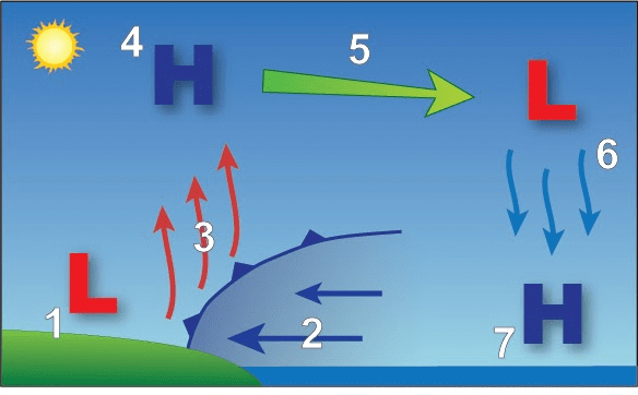 Representation of Low pressure and High-Pressure Zones
(b) The shift of the position of ‘Inter-Tropical Convergence Zone (ITCZ)’ as Sun moves Northwards.
The Inter-Tropical Convergence Zone (ITCZ) or Thermal Equator is a broad trough of low pressure in equatorial latitudes (it always remains on the north of the equator due to the effect of landmass).
This is where the northeast and the southeast trade winds converge, and this is a low-pressure zone.
This convergence zone lies more or less parallel to the equator but moves north or south with the apparent movement of the sun. At the time of monsoons, it shifts towards the north (towards India) and hence attracts moisture-laden winds.
According to meteorologists, Monsoon is the result of the shift of the ITCZ under the influence of the vertical sun towards the Tropic of Cancer.
The ITCZ is the lowest pressure zone in the tropical region, is the target destination for the Trade winds of both hemispheres.
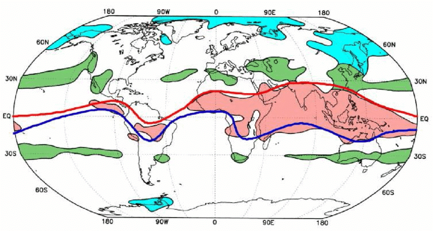 The geographical extent of the global surface monsoons.
The red, green, and blue areas indicate the tropical, subtropical, and temperate-frigid monsoons. The red and thick blue lines indicate the position of ITCZ in summer and winter, respectively.
Consequentially, with ITCZ at the Tropic of cancer (over the Indian peninsula), the southeast Trade winds of the Southern Hemisphere have to cross the equator to reach the ITCZ.
However, due to Coriolis Effect, these southeast trade winds are deflected eastwards in the Northern Hemisphere transforming into South West trades.
These pick up the moisture while traveling from sea to land and cause orographic rain once they hit the highlands of the Indian Peninsula. This results in the South-West Monsoon.
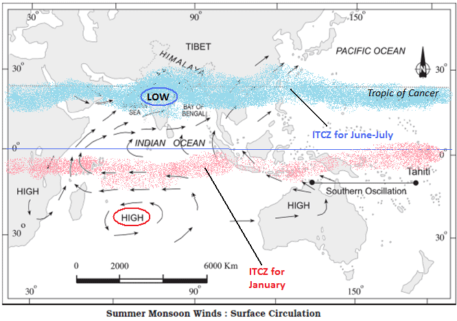
(c) The presence of the high-pressure area, east of Madagascar, approximately at 20°S over the Indian Ocean. The intensity and position of this high-pressure area affect the Indian Monsoon.
(d) The Tibetan plateau gets intensely heated, and low pressure is created over the plateau results in strong vertical air currents and low pressure over the plateau at about 9 km above sea level.
(e) The movement of the westerly jet stream to the north of the Himalayas and the presence of the tropical easterly jet stream over the Indian peninsula during summer.
It is also believed that the burst of monsoon succeeds the shift of this jet from the South of the Himalayas to the North of the Himalayas as their shifting allows the inflow of warm and wet winds to the sub-continent.
Effect of ENSO on Indian Monsoon
Apart from this, it has also been noticed that changes in the pressure conditions over the southern oceans also affect the monsoons.
El Nino is a warm current that flows off the coast of Peru. La Nina is its opposite and is a cold current that flows along the same coast but in opposite directions.
While Al-Nino is an oceanic phenomenon, SO is a weather/atmospheric phenomenon. Since ocean currents are closely linked with the atmospheric air circulations and pressure, this change of El Nino to La Nina also affects the pressure conditions.
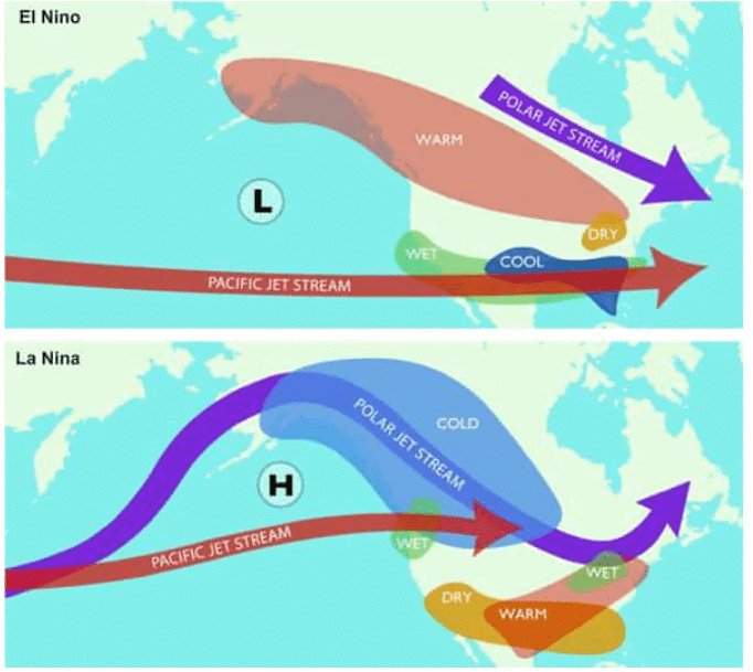 El Nino La Nina
- A standard measure is taken as the difference of pressure of Tahiti (An Island in the Pacific Ocean marked as ‘X’ and hence La Nino/La Nina) and Darwin in Australia (‘Z’, which is closer to India).
Normal Situation: Normally, when the tropical Eastern Pacific Ocean near Tahiti (see Fig marked as ‘X’) experiences high pressure, the tropical eastern Indian Ocean (see Figure, marked as ‘Y’) and Western Pacific Ocean near Darwin (‘Z’) experiences low pressure. It creates a negative pressure difference between Darwin/Indian Ocean and Tahiti = Z/X – Y.
Abnormal Situation: But in certain years, there is a reversal in the pressure conditions and the eastern Pacific (X) has lower pressure in comparison to the eastern Indian Ocean (Y) or Western Pacific Ocean (Z). It creates a condition of positive pressure difference between Darwin/Indian Ocean and Tahiti = Z/X – Y
This periodic change in pressure conditions is known as the Southern Oscillation or SO. Since El-Nino/La Nina and SO are interlinked they together are referred to as ENSO.
Effect of ENSO on India: Usually, if the pressure differences were negative, it would mean below average and late monsoons. i.e. During El-Nino Conditionsor Normal Conditionsweak monsoon is observed – though not always –and when La-Nina conditions exist though not always.

The Onset of the Monsoon
The Monsoons, unlike the trade winds, are not steady winds but are pulsating in nature, affected by different atmospheric conditions encountered by it, on its way over the warm tropical seas.
The duration of the monsoon is between 100- 120 days from early June to mid-September.
A burst of the monsoon: Around the time of its arrival, the normal rainfall increases suddenly and continues constantly for several days. This is known as the ‘burst’ of the monsoon and can be distinguished from the pre-monsoon showers.
Pre-Monsoon Showers or Mango Showers: Mango showers are the pre-monsoon showers in the Indian states of Karnataka, Kerala, Konkan, and Goa that help in the ripening of mangoes.
Also known as April rains or Summer showers, they are a result of thunderstorms over the Bay of Bengal.
These summer rains normally come in the second half of the month of April. The showers prevent the mangoes from dropping prematurely from trees and are crucial for the mango cultivators of South India.
Bifurcation of Monsoon Winds
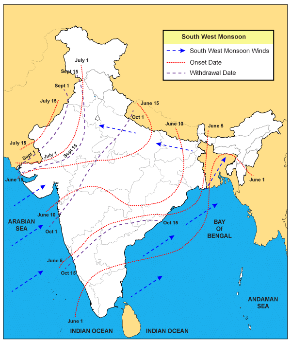
The monsoon arrives at the southern tip of the Indian peninsula generally by the first week of June. Subsequently, it proceeds into two – the Arabian Sea branch and the Bay of Bengal branch.
 Form of two branches viz. the Arabian Sea branch and the Bay of Bengal branch
The Arabian Sea branch further split into three branches:
(i) Sahayadri Branch:
Its one branch is obstructed by the Western Ghats.
These winds climb the slopes of the Western Ghats from 900-1200 m.
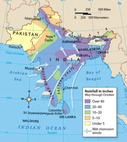
Soon, they become cool, and as a result, the windward side of the Sahyadris (the Western Ghats in Maharashtra) and Western Coastal Plain receive very heavy rainfall ranging between 250 cm and 400 cm.
This is the reason Mumbai gets high rainfall (190 cm) and the regions like Khandala even more (450cm) due to orographic rains and Pune doesn’t receive much as it falls on the leeward side of Ghats.
Rainshadow area of Western Ghats – After crossing the Western Ghats, these winds descend and get heated up. This reduces humidity in the winds. As a result, these winds cause little rainfall east of the Western Ghats. This region of low rainfall is known as the rain-shadow area.
(ii) Another branch of the Arabian Sea monsoon strikes the coast north of Mumbai.
Moving along the Narmada and Tapi River valleys, these winds cause rainfall in extensive areas of central India.
But these don’t cause many showers of rain as of Mumbai branch as there are no orographic rains and this is the reason that Nagpur receives comparatively lesser rainfall (while Mumbai receives 190 cm, Nagpur receives 60 cm)
The Chotanagpur plateau gets just 15 cm of rainfall from this part of the branch as it has lesser moisture by the time it reaches here.
Thereafter, they enter the Ganga plains and mingle with the Bay of Bengal branch.
(iii) Saurashtra Branch:
The third branch of this monsoon wind strikes the Saurashtra Peninsula and the Kachchh.
It then passes over west Rajasthan and along the Aravallis, causing only a scanty rainfall, but still some orographic effect is there which leads to relatively high rainfall in Mount Abu (however surrounding plains are relatively drier).
In Punjab and Haryana, it too joins the Bay of Bengal branch. These two branches, reinforced by each other, cause rains in the western Himalayas,
The Bay of Bengal Branch
The Bay of Bengal branch strikes the coast of Myanmar and part of southeast Bangladesh. But the Arakan Hills along the coast of Myanmar deflect a big portion of this branch towards the Indian subcontinent.
The monsoon, therefore, enters West Bengal and Bangladesh from the south and southeast instead of from the south-westerly direction.
From here, this branch splits into two under the influence of the Himalayas and the thermal low is northwest India.
(i) Northern Plains Branch: Its one branch moves westward due to obstruction by the Himalayas and moves along the Ganga plains reaching as far as the Punjab plains.
(ii) Brahmputra Valley Branch:
The other branch moves up the Brahmaputra valley in the north and the northeast, causing widespread rains.
Its sub-branch strikes the Garo and Khasi Hills of Meghalaya. Mawsynram, located on the crest of Khasi hills, receives the highest average annual rainfall in the world as it is located perpendicular to the direction of Monsoons and orographic rains are caused in abundance.
Delhi generally receives the monsoon showers from the Bay of Bengal branch by the end of June.
By the first week of July, western Uttar Pradesh, Punjab, Haryana, and eastern Rajasthan experience the monsoon.
By mid-July, the monsoon reaches Himachal Pradesh and the rest of the country.
The Arabian Sea and the Bay of Bengal branches of the monsoon merge over the northwestern part of the Ganga plains.
Arabian Sea branch is stronger than Bay of Bengal branch due to the following reasons:
(i) Arabian sea branch is larger than the Bay of Bengal Branch.
(ii) While Arabian Sea Branch enters into the Indian peninsula in its entirety, the Bay of Bengal branch enters partially with its parts also moving to other areas like Thailand, Myanmar, etc.
Break-in Monsoon-Shifting of Trough Towards Himalayas
Another phenomenon associated with the monsoon is its tendency to have ‘breaks’ in rainfall.
Thus, it has wet and dry spells.
In other words, the monsoon rains take place only for a few days at a time. They are interspersed with rainless intervals.
These breaks in the monsoon are related to the movement of the low-pressure zone or the monsoon trough. It is believed to be due to the collapse of Tibetan High and the trough shifts towards Himalayas and rainfall occurs in the Himalayan region leaving the plains dry and hence causing a break.
For various reasons, the ‘monsoon trough’ and its axis keep on moving northward or southward, which determines the spatial distribution of rainfall.
When the axis of the monsoon trough lies over the plains, rainfall is good in these parts.
On the other hand, whenever the axis shifts closer to the Himalayas, there are longer dry spells in the plains, and widespread rain occurs in the mountainous catchment areas of the Himalayan rivers.
These heavy rains bring in their wake, devastating floods causing damage to life and property in the plains.
The frequency and intensity of tropical depressions too, determine the amount and duration of monsoon rains.
These depressions form at the head of the Bay of Bengal and cross over to the mainland. The depressions follow the axis of the ‘monsoon trough of low pressure’.The monsoon is known for its uncertainties.
The alternation of dry and wet spells varies in intensity, frequency, and duration. While it causes heavy floods in one part, it may be responsible for droughts in the other. It is often irregular in its arrival and its retreat.
Hence, it sometimes disturbs the farming schedule of millions of farmers all over the country.
The Retreat of Monsoon
By the end of September, the southwest monsoon becomes weak as the low-pressure trough of the Ganga plain starts moving southward in response to the southward march of the sun.
It is a more gradual process. The withdrawal of the monsoon begins in the northwestern states of India by early September. By mid-October, it withdraws completely from the northern half of the peninsula.
The withdrawal from the southern half of the peninsula is fairly rapid. By early December, the monsoon has withdrawn from the rest of the country.
October Heat – The retreating southwest monsoon season is marked by clear skies and a rise in temperature. The land is still moist. Owing to the conditions of high temperature and humidity, the weather becomes rather oppressive. This is commonly known as the ‘October heat’.
The islands receive the very first monsoon showers, progressively from south to north, from the last week of April to the first week of May.
The withdrawal takes place progressively from north to south from the first week of December to the first week of January. By this time the rest of the country is already under the influence of the winter monsoon.
Winter monsoons do not cause rainfall as they move from land to the sea. It is because they have little humidity.
Characteristics of Monsoonal Rainfall
It is mainly Orographic in Nature – the Western Ghats, the Himalayas play an important role. At the same time, Aravali fails to play a role because it runs parallel to the advancing monsoons
It occurs in Torrents – Only a few months cause the majority of the rain. It is variable in nature.
Rainfall received from the southwest monsoons is seasonal in character.
Monsoonal rainfall is largely governed by relief or topography. For instance, the windward side of the Western Ghats registers a rainfall of over 250 cm.
Again, the heavy rainfall in the north-eastern states can be attributed to their hill ranges and the Eastern Himalayas.
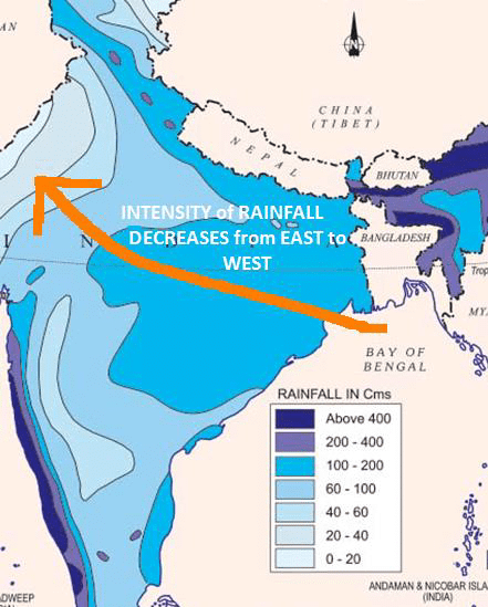
The monsoon rainfall has a declining trend with increasing distance from the sea. Kolkata receives 119 cm during the southwest monsoon period, Patna 105 cm, Allahabad 76 cm, and Delhi 56 cm.
The summer rainfall comes in a heavy downpour leading to considerable runoff and soil erosion.
The monsoon rains occur in wet spells of a few days duration at a time. The wet spells are interspersed with rainless intervals known as ‘breaks’.
Monsoons play a pivotal role in the agrarian economy of India because over three-fourths of the total rain in the country is received during the southwest monsoon season.
So even weak monsoons mean a gamble with crops as farmers depend on it heavily and other irrigation systems are not well developed. With still more than 50% population depending upon agriculture, it has a great economic impact.
Its spatial distribution is also uneven which ranges from 12 cm to more than 250 cm.
Monsoons And The Economic Life in India
Monsoon is that axis around which revolves the entire agricultural cycle of India. It is because about 64 percent of people of India depend on agriculture for their livelihood and agriculture itself is based on the southwest monsoon.
Except for the Himalayas, all the parts of the country have temperatures above the threshold level to grow the crops or plants throughout the year.
Regional variations in monsoon climate help in growing various types of crops.
Variability of rainfall brings droughts or floods every year in some parts of the country.
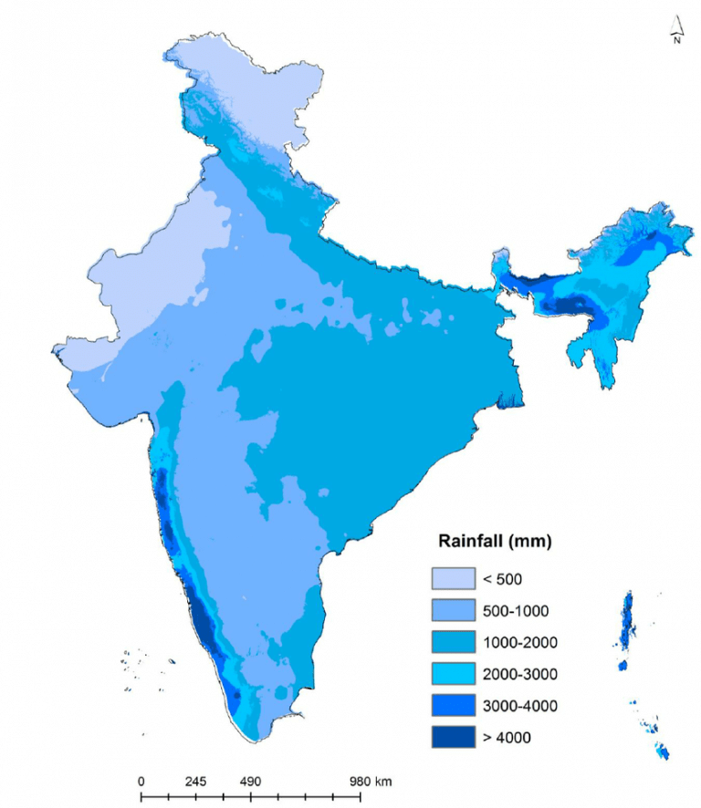 Map showing rainfall distribution in India
- The agricultural prosperity of India depends very much on time and adequately distributed rainfall. If it fails, agriculture is adversely affected particularly in those regions where means of irrigation are not developed.
Sudden monsoon burst creates the problem of soil erosion over large areas in India.
Tamil Nadu and Southwest Monsoons
Tamil Nadu coast remains dry during this season. These are the factors responsible for it.
The Tamil Nadu coast is situated parallel to the Bay of Bengal branch of the southwest monsoon.
It lies in the rain shadow area of the Arabian Sea branch of the southwest monsoon.
Tamil Nadu on the other hand gets rain from the retreating monsoon or the North East Monsoon as it picks moisture from the Bay of Bengal.
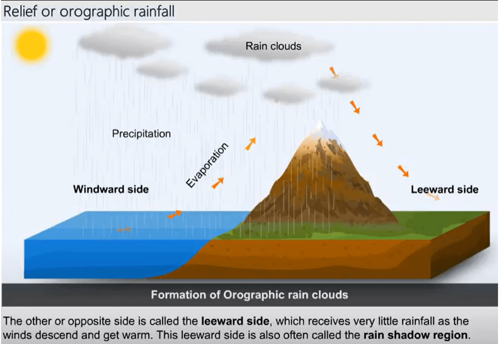
The Thar Desert and Monsoon
The reason that Thar has formed in the West of India is probably explained by the lack of rainfall.
The lack of rainfall is mainly due to the unique position of the desert with respect to the Aravalli range.
The desert lies in the rain shadow area of the Bay of Bengal arm of the southwest monsoon.
- The parallel nature of the range to the Arabian Sea arm also means that the desert does not receive much rainfall.
El Niño Modoki
- El Niño Modoki is a coupled ocean-atmosphere phenomenon in the tropical Pacific.
- It is different from another coupled phenomenon in the tropical Pacific namely, El Niño.
- Conventional El Niño is characterized by strong anomalous warming in the eastern equatorial Pacific.
- Whereas, El Niño Modoki is associated with strong anomalous warming in the central tropical Pacific and cooling in the eastern and western tropical Pacific (see figure below).
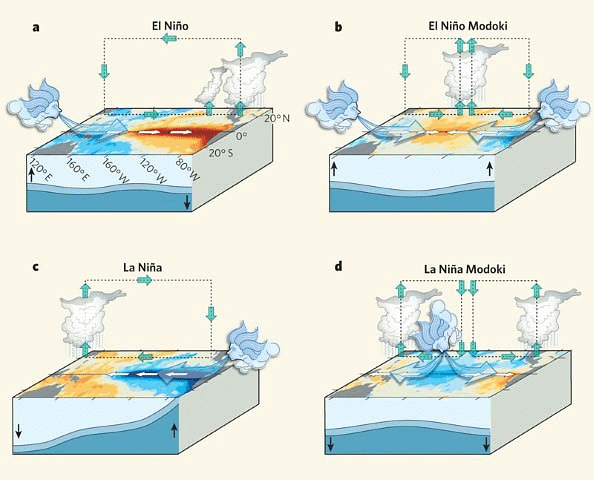
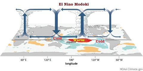
El Niño Modoki Impacts
- The El Niño Modoki phenomenon is characterized by the anomalously warm central equatorial Pacific flanked by anomalously cool regions in both west and east.
- Such zonal gradients result in anomalous two-cell Walker Circulation over the tropical Pacific, with a wet region in the central Pacific.
|
182 videos|620 docs|192 tests
|
FAQs on Monsoons: Indian Geography - Geography for UPSC CSE
| 1. What is the mechanism of monsoons and how do they form? |  |
| 2. How does the El Niño-Southern Oscillation (ENSO) affect the Indian monsoon? |  |
| 3. What is the significance of the onset of the monsoon in India? |  |
| 4. What are the characteristics of monsoonal rainfall in India? |  |
| 5. How do monsoons impact the economic life in India? |  |


