Previous Year Questions: Physical Features of India | Social Studies (SST) Class 9 PDF Download

Very Short Answer Type Questions
Q1. Name the most continuous range of Himalayas consisting of the lofty peaks.
Ans: Himadri or Greater or Inner Himalayas.
Q2. Name the mountain range which bounds Central Highlands on the north west.
Ans: Aravalli Hills.
Q3. How long are east-west distances covered by the Himalayas?
Ans: 2,400 km.
Q4. Which river marks the easternmost boundary of the Himalayas?
Ans: The Brahmaputra.
Q5. Which is the most important and longest mountain range of Himachal Himalaya?
Ans: The Pir Panjal range forms the longest and the most important range.
Q6. Why are the Himalayas called the young fold mountains?
Ans: The Himalayas are not very old, they are of recent birth. So they are called the young fold mountains.
Q7. Which is the highest peak of India?
Ans: Kanchenjunga (8,598 m).
Q8. Which is the highest peak of the Deccan Plateau?
Ans: The Anaimudi hill in Kerala.
Q9. Name some hill stations of the Himachal range.
Ans: Mussoorie, Chakrata, Nainital, Ranikhet and Almora.
Q10. In which hill does the Narmada river rise?
Ans: Amarkantak hills in Madhya Pradesh.
Q11. In which state Garo, Khasi and Jaintia hills are located?
Ans: Meghalaya.
Q13. What is the northern and southern extension of the western coast called?
Ans: Northern → Konkan coast, Southern → Malabar coast.
Q14. Which plateau lies between the Aravalli and the Vindhya ranges?
Ans: The Malwa Plateau.
Q15. Name some of the important passes of the Himalayas from west to east.
Ans: Shipkila, Nathula and Bomdila.
Q16. Name any two hills which comprise the ‘Purvanchal.
Ans: The Patkai, Naga, Manipur and the Mizo hills, (any two)
Q17. Why are the Northern Plains primarily an agricultural belt?
Ans: The Northern Plains have a thick soil cover composed of fine silt or alluvium brought down by the Himalayan rivers. This alluvial soil is very fertile. Hence, this is primarily an agricultural belt.
Q18. Name the major rivers of North India.
Ans: The Indus, the Sutlej, the Ganga, the Yamuna, the Kosi, the Teesta and ; the Brahmaputra are the major rivers of North India.
Q19. What is the width of the northern plains?
Ans: Its width varies from 240 to 320 kilometres. It gets narrower towards the east.
Q20. By which name, the coastal plain is known as in:
(i) Northern part
(ii) Southern part
Ans:
(i) Nortern part — Northern Circar.
(ii) Southern part — Coromandal Coast.
Q21. What is ‘barchan’?
Ans: It is crest shaped sand dune with cusps of the crescent pointing downward.
Q22. Mention any two characteristics of the Aravalli Hills.
Ans: The Aravalli Hills are eroded hills.
They extend from Gujarat to Delhi in a southwest — northeast direction.
Q23. Name any two peaks of the Western Ghat
Ans:
- Anaimudi (2,695 m),
- Doda Betta (2,637 m).
Q24. What are the two divisions of Peninsular Plateau?
Ans: The Central Highlands and the Deccan Plateau.
Q25. Which physical feature marks the Western and the Eastern edges of the Deccan Plateau?
Ans: The Western Ghats and the Eastern Ghats.
Q26. Where are the Lakshadweep Islands situated?
Ans: In the Arabian Sea.
Short Answer Type Questions
Q1. Explain the theory of Plate Tectonics.
Ans: According to this theory, the crust of the earth has been formed out of seven major and some minor plates. The movement of these plates led to folding, faulting and volcanic activity. These are classified in three categories:
- Convergent Boundary: When plates come .towards each other, also called folding movement.
- Divergent Boundary: When plates move away from each other, also called faulting movement.
- Transform Boundary: In the event of coming together, they may collide or may slide under each other.
Q2. What is the difference between a tributary and a distributary?
Ans:
- A Tributary: A tributary is that river which joins the main river, and increases the volume of water. It is generally found in the upper or the middle course of a river. For example, the Yamuna is the main tributary of the river Ganga.
- A Distributary: It is that river which originates from a main river. It is formed near the river’s mouth before it falls into the sea. It is found in the lower course of the river. For example, the Hooghly is the main distributary of the Ganga.
Q3. Name the three major divisions of Himalayas from the north to south.
Ans: The three major divisions of Himalayas from north to south are:
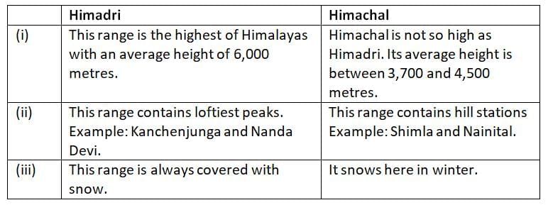
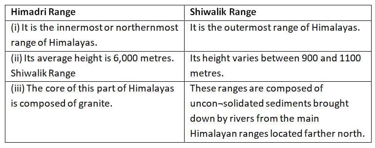
- The northernmost range which is known as the Great Himalayas or Inner Himalayas or Himadri. It is the most continuous range consisting of the loftiest peaks. It has an average height of 6000 meters. It consists of all the prominent Himalayan peaks.
- The southern range of Himadri which is known the Himachal or the lesser Himalayas lies to the South of Himadri. It forms the most rugged mountain system. The ranges are mainly composed of highly compressed and altered rocks. The altitude varies between 3700 and 4500 meters and its average width is 50 kms.
- The outermost range of the Himalayas is known as Shiwaliks. Its height varies between 900 meters and 1100 meters. This range is composed of unconsolidated sediments brought down by rivers from the main Himalayan ranges. These are also called foothill ranges. They represent the southernmost divison of Himalaya.
Q4. Name the southernmost range of Himalaya. Mention any four features of this range.
Ans: The southernmost range of Himalayas is called Shiwaliks.
Features:
- The outermost range of the Himalayas is called the Outer Himalayas or Shiwaliks.
- They extend over a width of 10-15 km.
- Their altitude varies between 900-1100 metres.
- They are discontinuous ranges and are composed of unconsolidated sediments, gravel and alluvium brought down by the rivers from main Himalayan ranges located farther north.
- Longitudinal valleys known as Duns lie between the lesser Himalayas and Shiwaliks. e.g., Dehradun, Kote Dun, Path Dun.
Q5. How is Himadri range different from Himachal range? Mention any three differences.
Ans:
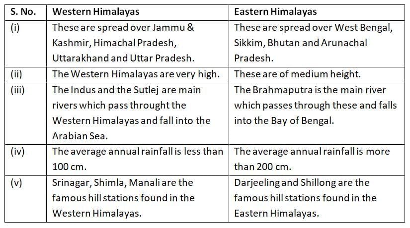
Q6. Differentiate between Western Himalayas and Eastern Himalayas.
Ans:
Q7. Write about the main features of the Shiwaliks.
Ans:
- It is the outermost range of the Himalayas.
- The average altitude of the Shiwalik range varies between 900 m and 1,100 m above the sea level, and extends over a width of about 10-50 km.
- This range is made of unconsolidated material such as mud, silt and soft rocks and is prone to earthquakes and landslides.
- Some narrow valleys are found between the Shiwaliks and the Himachal. They are called ‘duns’. For example, Dehradun, is situated in one such valley.
Q8. How did the northern plains come to existence? Write two points briefly. Also mention two features of these plains.
Ans: (i) The northern plains have been formed by the interplay of the three major river systems, i.e., the Indus, the Ganga and the Brahmaputra.
(ii) The northern plain is formed of the alluvial soil brought by these rivers.
Features:
- These plains are very fertile.
- These are densely polulated.
Q9. Why are Northern Plains agriculturally productive parts of India? Explain.
Ans:
- The deposition of alluvium in a vast basin lying at the foothills of the Himalaya over millions of years, formed this fertile plain. It spreads over an area of 7 lakh sQuestion km.
- The plain being about 2400 km. long and 240 to 320 km. broad, is a densely populated physiographic division.
- With a rich soil cover combined with adequate water supply and favourable climate, it is agriculturally a very productive part of India.
Q10. Which three river systems form the northern plains of India? Mention main features.
Ans: The northern plain has been formed by the interplay of the three major river systems—the Indus, the Ganga and the Brahmaputra.
- The river Indus and its tributaries form the western part of the northern plain which is referred to as the Punjab plains. The larger part of this plain lies in Pakistan.
- The Ganga plain extends between Ghaggar and Teesta rivers. It spreads over the states of North India; Haryana, Delhi, U.P., Bihar, partly Jharkhand and West Bengal.
- The Brahmaputra plain particularly lies mainly in Assam. It forms the largest riverine islands in the world.
Q11. State any three differences between Himadri range and Shiwalik range.
Ans:
Q12. What is a delta? Name some deltas of the Indian sub-continent.
Ans: The triangular deposition of sediments at the mouth of a river is known as a delta.
- The Ganga-Brahmaputra Delta.
- The Mahanadi Delta.
- The Godavari Delta.
- The Krishna Delta.
- The Kaveri Delta.
Q13. What are Purvanchal hills? Mention any two features of these hills.
Ans: Mountains along the eastern boundary of India are called the Purvanchal. There are medium heights.
Some of the important mountains of Purvanchal are:
- The Patkoi Bum and the Naga Hills in the North.
- The Mizo Hills in the South.
- The Jaintia, the Khasi and the Garo hills from east to west.
Features:
- They comprise of sandstone and sediments.
- They are covered with dense forests.
- They comprise of Patkoi Hills, Manipur hills etc. (any two)
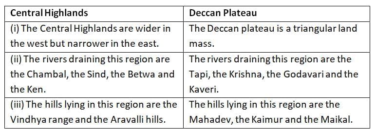
Q14. Distinguish between Central highlands and Deccan Plateau on the basis of rivers that flow and hill ranges.
Ans:
Q15. Give an account of the Deccan Plateau.
Ans: An account of Deccan Plateau of India:
- It is a triangular landmass that lies to the south of the river Narmada. The Satpura range flanks its broad base in the north while the Mahadev forms its eastern extensions.
- The Deccan Plateau is higher in the west and slopes gently eastwards.
- An extension of the Plateau is also visible in the north-east. It is locally known as the Meghalaya, Karbi Anglong Plateau and North Cachar Hills.
- It is separated by a fault from the Chhotanagpur Plateau. Three prominent hill ranges form the West to East are the Garo, the Khasi and the Jaintia Hills. The Western Ghats and the Eastern Ghats mark the Western and Eastern edges of the Deccan Plateau respectively. The Western Ghats lie parallel to the western coast and Eastern Ghats, lie parallel to the eastern coast.
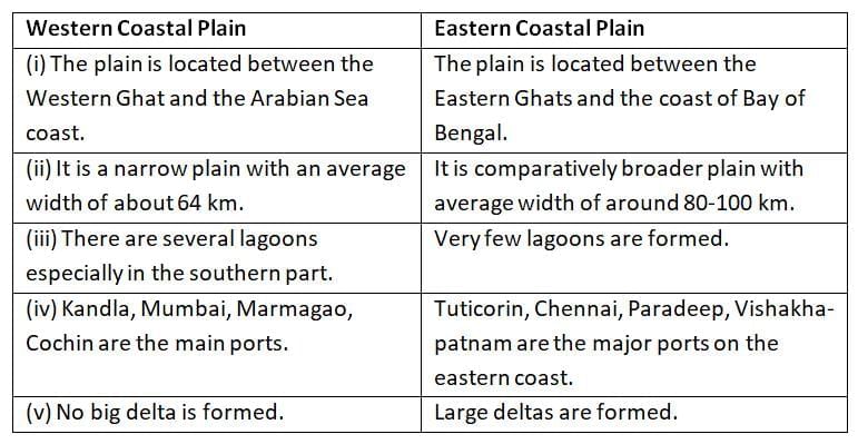
Q16. Compare the main features of the Western Coastal Plain and Eastern Coastal Plain.
Ans:
Q17. Name the four major states which are the parts of the eastern coastal plains. Mention the two divisions of these coastal plains.
Ans: The plains extend from the state of Tamil Nadu in the southern part to the state of West Bengal in the northern region of India. Other states include Andhra Pradesh and Odisha. The three main divisions into which the eastern coastal plains can be divided are Utkal Plains, Tamil Nadu Plains and the Andhra Plains.
- Utkal Plains: This is the coastal stretch of the state of Odisha and consists of the Mahanadi delta. The famous feature of the region is the Chilka Lake lying on the south of the Mahanadi Delta.
- Tamil Nadu Plains: The plains extend from the Pulicat Lake to Kanyakumari. The prominent feature of the region is the Kaveri delta, the fertile soil and irrigational facilities of which make it a granary in South India.
- Andhra Plains: The plains extend from the Utkal Plains on the North to Pulicat Lake in the south. The delta formation by the rivers Kaveri and Godavari happens to be the important feature of the region.
Q18. Describe any three features of coastal plains of India.
Ans:
- The Peninsular plateau is flanked by a strip of narrow coastal strips running along the Arabian Sea on the west and the Bay of Bengal on the east.
- The western coast, sandwiched between the Western Ghats and the Arabian Sea, is a narrow plain. It consists of three sections. The northern part of the coast is called the Konkan (Mumbai-Goa), the central stretch is called the Kannad Plain while the southern stretch is referred to as the Malabar coast.
- The plains along the Bay of Bengal are wide and level.
- In the northern part, it is referred to as the Northern Gircar, while the southern part is known as the Coromandel Coast.
- Large rivers such as the Mahanadi, the Godavari, the Krishna and the Kaveri have formed extensive delta on this coast. Lake Chilka is an important feature along the eastern coast.
Q19. Name two island groups possessed by India. Mention one feature of each.
Ans:
- The Andaman and Nicobar Islands: This group of island is composed of small coral islands.
- Lakshadweep Islands: These are bigger in size and are more numerous and scattered.
Q20. Write a note on corals.
Ans:
- Corals are small, sedentary marine animals with a calcareous homy skeleton.
- These thrive in warm shallow water and grow into large colonies called coral reefs.
- They secrete hard rock like substance. The coral secretion and their skeletons form coral deposits in the form of reefs.
- They are mainly of three kinds: barrier reef, fringing reef and atolls.
- The Great Barrier Reef of Australia and Lakshadweep Islands are a good example of the first kind of coral reefs.
Q21. Explain the formation of the Peninsular Plateau. Write any four of its distinct features.
Ans: The Peninsular Plateau was formed due to the breaking and drifting of the Gondwana land. It is a tableland composed of the old crystalline, igneous and metamorphic rocks.
- It has broad and shallow hills, valleys and rounded hills.
- It consists of the two broad divisions namely, the Central Highland and Deccan Plateau.
- It has black soil area known as Deccan Trap which is of volcanic origin.
- The flow of rivers is westward.
Long Answer Type Questions
Q1. “The land of India displays great physical variations”. Justify this statement with five examples.
Ans: Physical variations of land of India are:
- Geologically, the Peninsular Plateau constitutes one of the ancient landmasses on the earth’s surface. It was supposed to be one of the most stable land blocks.
- The Himalayas and the Northern Plains are the most recent landforms.
- From the yiew point of geology, Himalayan Mountains form an unstable zone.
- The whole mountain system of Himalaya represents a very youthful topography with high peaks, deep valleys and fast flowing rivers.
- The Northern Plains are formed of alluvial deposits.
- The Peninsular Plateau is composed of igneous and metamorphic rocks with gently rising hills and wide valleys, (any five)
Q2. “Each physiographic region of India complements the other and makes the country richer in its natural resources.” Justify this statement with five examples.
Or
‘The diverse physical features of India are of immense value’. Justify the statement by giving suitable examples.
Ans: Importance of diverse physical features of India is as follows:
- The northern mountains are the major sources of water and forest wealth.
- The northern plains are the granaries of the country. They provide the base for early civilisations.
- The plateau is a storehouse of minerals which has played a crucial role in the industrialisation of the country.
- The coastal region and island groups provide sites for fishing and port activities.
- The deserts are the storehouse of solar energy.
Q3. Explain the three types of plates and write the effects of movements of plates.
Ans: The plate movements are classified into three types:
- Some plates come towards each other and form convergent boundaries.
- Some plates move away from each other and form divergent boundary.
- At times, they may also move horizontally pass each other and form transform boundary.
When two plates come together, they are known as convergent plates. They are also known as constructive plates. When two plates move far away from each other, they are known as divergent plates. When two plates coming towards each other collide or burst pass, they are known as transform plate. The movement of plates causes volcanic eruptions, earthquakes, formation of mountains etc.
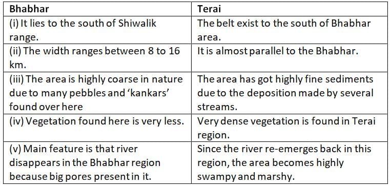
Q4. Distinguish between Bhabhar and Terai.
Ans:
Q5. Describe any five features of northern plains of India.
Ans: Features of northern plains of India are:
- The northern plains have been formed from the alluvium deposited by the mountain rivers.
- They are located between the Himalayan rivers in the north and the Peninsular Plateau in the south.
- They turned the soil on the surfaced land fertile for growing a rich harvest of variety of crops. This led to the development of the Indus river valley civilization.
- They are made up of deposits of alluvium and cover an area of 7 lakh sQuestion km.
- They are densely populated physiographic division of India and are believed to be highly productive in terms of agriculture.
- The North Indian plains have the Indus river system in the west and the Ganga, Brahmaputra river system in the East.
- The first include Jhelum, Chenab, Rabi, Beas. The Indus flows into the Arabian Sea. The second includes Ganga-Brahmaputra which combines with Meghna at the point when it drains into the Bay of Bengal. They form the world’s largest and fastest growing delta. On the basis of difference of relief, they are divided into four parts—Bhabhar, Terai, Bhangar and Khadar.
- The northern plain is divided into three sections— Punjab plain, Ganga plain and Brahmaputra plain.
The Ganga plain has diverse relief features. It has four belts:
- Bhabhar is a belt of pebbles extending from 8-16 kms in width in which stream disappears.
- Terai is a wet, swampy, marshy region with thick forests and wildlife.
- Bhangar is a terrace-like feature made of old alluvium. It contains calcareous deposits called Kankar.
- Khadar is the flood plain which renewed everywhere and is very fertile.
Q6. Which is the oldest land mass of India? Name its two hroad divisions and explain any three features of each.
Ans: The Great Peninsular Plateau lies to the south of the great plains and is , the oldest land mass of India. It is triangular in shape. The river
Narmada divides it into two parts:
- The Cental Highlands and
- The Deccan Plateau.
The Central Highlands:
- It is made up of hard igneous and metamorphic rocks.
- It comprises the Malwa Plateau, the small plateau of Bundelkhand and the Chhota Nagpur Plateau while the Western Ghats extend to the west of the Deccan Plateau.
- Chambal, Sind and Betwa are three important rivers which flow through the Central Highlands.
- It has been’drained by tributaries of Yamuna and Ganga.
- Bundelkhand in southern UP and Baghelkhand in northern Madhya Pradesh.
The Deccan Plateau:
- It is a triangular landmass that lies to the south of river Narmada.
- It is higher in the west and slopes gendy eastwards.
- It is the largest unit of the Peninsular Plateau of India.
- Satpura range, Mahadev hills, Maikal range covers northern edge.
- It is the oldest block made up of igneous and metamorphic rocks.
Q7. Describe any five features of the Central highlands of India.
Ans: Features of Central Highlands:
- The part of the Peninsular Plateau lying to the north of the Narmada river covering major area of the Malwa Plateau is known as the Central Highland.
- The Vindhyan range is bounded by the Central Highland on the south and the Aravallis on the northwest. The further westward extension gradually merges with the sandy and rocky desert of Rajasthan.
- The flow of the rivers draining this region, namely Chambal, the Sind, the Betwa and Ken is from southwest to northeast, thus indicating the slope.
- The Central Highlands are wider in the West but narrower in the East.
- The eastward extensions of this plateau are locally known as the Bundelkhand and Baghelkhand.
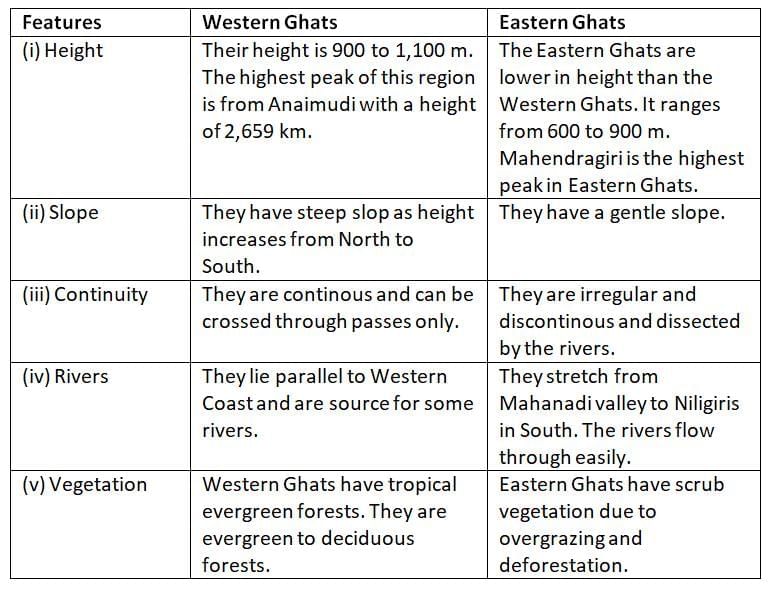
Q8. Describe the features of Western Ghats and Eastern Ghats in reference to height, slope, continuity, rivers and vegetation.
Ans:
|
55 videos|525 docs|78 tests
|
FAQs on Previous Year Questions: Physical Features of India - Social Studies (SST) Class 9
| 1. What are the major physical features of India? |  |
| 2. How do the Himalayas influence the climate of India? | |
| 3. What is the significance of the Indo-Gangetic Plain? | |
| 4. Describe the characteristics of the Deccan Plateau. | |
| 5. What are the coastal features of India? | |


practice quizzes
,past year papers
,shortcuts and tricks
,Previous Year Questions: Physical Features of India | Social Studies (SST) Class 9
,Free
,Viva Questions
,mock tests for examination
,Previous Year Questions with Solutions
,Exam
,video lectures
,Previous Year Questions: Physical Features of India | Social Studies (SST) Class 9
,Important questions
,Previous Year Questions: Physical Features of India | Social Studies (SST) Class 9
,study material
,Extra Questions
,Semester Notes
,Objective type Questions
,ppt
,MCQs
,Sample Paper
,Summary
;


Previous Year Questions: Physical Features of India Free PDF Download
Importance of Previous Year Questions: Physical Features of India
Previous Year Questions: Physical Features of India Notes
Previous Year Questions: Physical Features of India Class 9
Study Previous Year Questions: Physical Features of India on the App
|
© EduRev
|
Education Revolution
|


|


within 7 days!