Landforms & their Evolution - 1 Class 11 Geography
| Table of contents |
|
| Landform |
|
| Running Water |
|
| Erosional Landforms |
|
| Depositional Landforms |
|
| Groundwater |
|
| Glaciers |
|
Landform
Small to medium tracts or parcels of the earth’s surface are called landforms.
- Each landform has its own physical shape, size, materials and is a result of the action of certain geomorphic processes and agent.
- Several landforms together are called landscape.
- Due to changes in climate and vertical and horizontal movements landforms change their shape.
- Each landform undergo three stages called youth, mature and old stages.
- Geomorphology is the science of landforms. Various geomorphic agents bring the changes to the landforms such as running water, moving ice, wind glaciers, underground water, waves by erosion and deposition.
- Each geomorphological agent produces its own assemblage of landforms. Most of the geomorphological processes are imperceptible. The study of the landforms reveals that the stage structure and process of land forms. They produce erosional and depositional features.
 Landform

Factors influencing erosion
- Rock structures such as fold, fault, joints, fractures, hardness, softness permeability, and impermeability.
- Stability of sea level
- Tectonic stability of landmass
- Climate
Running Water
- In regions with high humidity and heavy rainfall, running water is considered the primary geomorphic agent responsible for land surface degradation.
- This is due to two types of running water: overland flow that spreads over the surface in a sheet and linear flow in valleys as streams and rivers. Erosional landforms created by running water are predominantly associated with youthful rivers flowing over steep gradients.
- As time passes, stream channels flowing over steep gradients become gentler due to ongoing erosion, leading to a decrease in their velocity and an increase in active deposition. The more gentle the slope of a river channel, the greater the deposition. As stream beds become gentler due to continued erosion, downward cutting becomes less dominant, while lateral erosion of banks increases. This process results in the reduction of hills and valleys to flat plains.Question for Revision Notes: Landforms & their Evolution - 1Try yourself:Which of the following statements best describes the primary geomorphic agent responsible for land surface degradation in regions with high humidity and heavy rainfall?View Solution
Overland flow
 Overland Flow
- It causes sheet erosion.
- Depending upon irregularities of the land surface, the overland flow may concentrate into narrow to wide paths.
- Because of the sheer friction of the column of flowing water, minor or major quantities of materials from the surface of the land are removed in the direction of flow and gradually small and narrow rills will form.
- These rills will gradually develop into long and wide gullies; the gullies will further deepen, widen, lengthen and unite to give rise to a network of valleys.
- The divides between drainage basins are likewise lowered until they are almost completely flattened leaving finally, a lowland of faint relief with some low resistant remnants called monadnocks standing out here and there.
- This type of plain forming as a result of stream erosion is called a peneplain (an almost plain.)
The characteristics of each of the stages of landscapes developing in running water regimes may be summarised as follows:
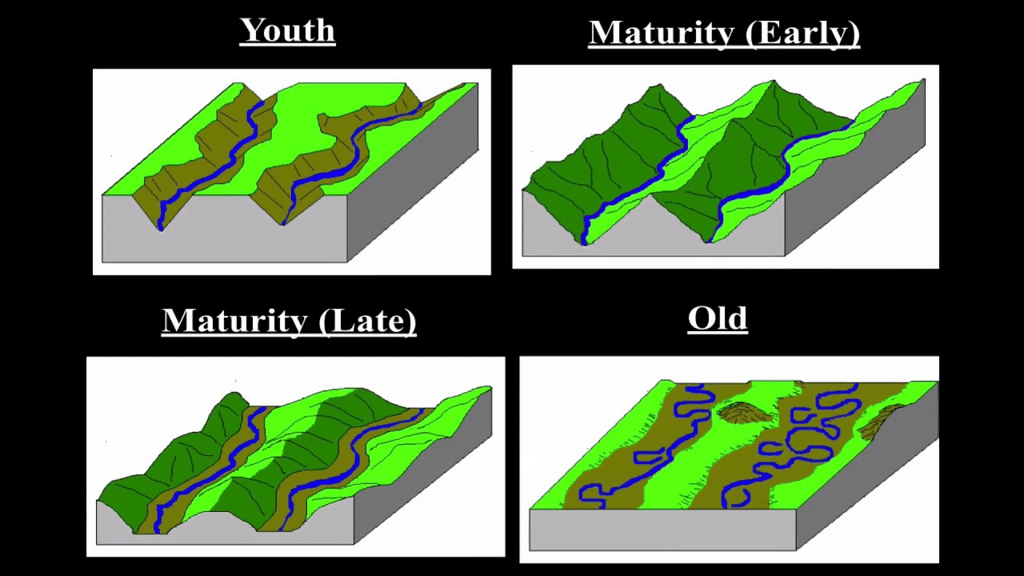 Stages of Landscape
Youth
- Streams are few during this stage with poor integration and flow over original slopes showing shallow V-shaped valleys with no floodplains or with very narrow floodplains along trunk streams.
- Streams divides are broad and flat with marshes, swamp and lakes.
- Meanders if present develop over these broad upland surfaces. These meanders may eventually entrench themselves into the uplands.
- Waterfalls and rapids may exist where local hard rock bodies are exposed.
Mature
- During this stage streams are plenty with good integration.
- The valleys are still V-shaped but deep; trunk streams are broad enough to have wider floodplains within which streams may flow in meanders confined within the valley.
- The flat and broad inter stream areas and swamps and marshes of youth disappear and the stream divides turn sharp.
- Waterfalls and rapids disappear.
Old
- Smaller tributaries during old age are few with gentle gradients.
- Streams meander freely over vast floodplains showing natural levees, oxbow lakes, etc.
- Divides are broad and flat with lakes, swamps and marshes. Most of the landscape is at or slightly above sea level.
Erosional Landforms
Valleys
- Valleys start as small and narrow rills; the rills will gradually develop into long and wide gullies; the gullies will further deepen, widen and lengthen to give rise to valleys. Depending upon dimensions and shape, many types of valleys like V-shaped valley, gorge, canyon, etc. can be recognised.
- A gorge is a deep valley with very steep to straight sides and a canyon is characterised by steep step-like side slopes and may be as deep as a gorge. A gorge is almost equal in width at its top as well as its bottom. In contrast, a canyonis wider at its top than at its bottom. In fact, a canyon is a variant of gorge.
- Valley types depend upon the type and structure of rocks in which they form. For example, canyons commonly form in horizontal bedded sedimentary rocks and gorges form in hard rocks.
Potholes and Plunge Pools
 Plunge Pool
- Over the rocky beds of hill-streams more or less circular depressions called potholes form because of stream erosion aided by the abrasion of rock fragments.
- Once a small and shallow depression forms, pebbles and boulders get collected in those depressions and get rotated by flowing water and consequently the depressions grow in dimensions.
- A series of such depressions eventually join and the stream valley gets deepened. At the foot of waterfalls also, large potholes, quite deep and wide, form because of the sheer impact of water and rotation of boulders. Such large and deep holes at the base of waterfalls are called plunge pools.
- These pools also help in the deepening of valleys. Waterfalls are also transitory like any other landform and will recede gradually and bring the floor of the valley above waterfalls to the level below.
Incised or Entrenched Meanders
- In streams that flow rapidly over steep gradients, normally erosion is concentrated on the bottom of the stream channel.
- Also, in the case of steep gradient streams, lateral erosion on the sides of the valleys is not much when compared to the streams flowing on low and gentle slopes.
- Because of active lateral erosion, streams flowing over gentle slopes, develop sinuous or meandering courses. It is common to find meandering courses over floodplains and delta plains where stream gradients are very gentle.
- But very deep and wide meanders can also be found cut in hard rocks. Such meanders are called incised or entrenched meanders.
- Meander loops develop over original gentle surfaces in the initial stages of development of streams and the same loops get entrenched into the rocks normally due to erosion or slow, continued uplift of the land over which they start.
- They widen and deepen over time and can be found as deep gorges and canyons in hard rock areas. They give an indication on the status of original land surfaces over which streams have developed.
River Terraces
- River terraces are surfaces marking old valley floor or floodplain levels.
- They may be bedrock surfaces without any alluvial cover or alluvial terraces consisting of stream deposits.
- River terraces are basically products of erosion as they result due to vertical erosion by the stream into its own depositional floodplain.
- The river terraces may occur at the same elevation on either side of the rivers in which case they are called paired terraces.
- When a terrace is present only on one side of the stream and with none on the other side or one at quite a different elevation on the other side, the terraces are called unpaired terraces.
- Unpaired terraces are typical in areas of slow uplift of land or where the water column changes are not uniform along both the banks.
- The terraces may result due to (i) receding water after a peak flow; (ii) change in hydrological regime due to climatic changes; (iii) tectonic uplift of land; (iv) sea level changes in case of rivers closer to the sea.
Depositional Landforms
Alluvial Fans
- Alluvial fans are formed when streams flowing from higher levels break into foot slope plains of low gradient.
- Normally very coarse load is carried by streams flowing over mountain slopes. This load becomes too heavy for the streams to be carried over gentler gradients and gets dumped and spread as a broad low to high cone shaped deposit called alluvial fan.
- Usually, the streams which flow over fans are not confined to their original channels for long and shift their position across the fan forming many channels called distributaries.
- Alluvial fans in humid areas show normally low cones with gentle slope from head to toe and they appear as high cones with steep slope in arid and semi-arid climates
Deltas
- Deltas are like alluvial fans but develop at a different location.
- The load carried by the rivers is dumped and spread into the sea. If this load is not carried away far into the sea or distributed along the coast, it spreads and accumulates as a low cone.
- Unlike in alluvial fans, the deposits making up deltas are very well sorted with clear stratification.
- The coarsest materials settle out first and the finer fractions like silts and clays are carried out into the sea. As the delta grows, the river distributaries continue to increase in length and delta continues to build up into the sea.
Floodplains, Natural Levees and Point Bars
Floodplain:
- It is a major landform of river deposition. Large sized materials are deposited first when stream channel breaks into a gentle slope. Thus, normally, fine sized materials like sand, silt and clay are carried by relatively slow moving waters in gentler channels usually found in the plains and deposited over the bed and when the waters spill over the banks during flooding above the bed.
- Deposition develops a floodplain just as erosion makes valleys.
- A river bed made of river deposits is the active floodplain. The floodplain above the bank is inactive floodplain.
- Inactive floodplain above the banks basically contain two types of deposits — flood deposits and channel deposits.
- The flood deposits of spilled waters carry relatively finer materials like silt and clay.
- The flood plains in a delta are called delta plains.
Natural levees:
 Natural Levee
- They are found along the banks of large rivers. They are low, linear and parallel ridges of coarse deposits along the banks of rivers, quite often cut into individual mounds.
- During flooding as the water spills over the bank, the velocity of the water comes down and large sized and high specific gravity materials get dumped in the immediate vicinity of the bank as ridges. They are high nearer the banks and slope gently away from the river.
- The levee deposits are coarser than the deposits spread by flood waters away from the river. When rivers shift laterally, a series of natural levees can form.
Point bars:
- They are also known as meander bars.-They are found on the convex side of meanders of large rivers and are sediments deposited in a linear fashion by flowing waters along the bank.
- Almost uniform in profile and in width and contain mixed sizes of sediments.
- If there more than one ridge, narrow and elongated depressions are found in between the point bars.
- As the rivers build the point bars on the convex side, the bank on the concave side will erode actively.
Meanders
- In large flood and delta plains, rivers rarely flow in straight courses. Loop-like channel patterns called meanders develop over flood and delta plains.
- Meander is not a landform but is only a type of channel pattern. This is because of propensity of water flowing over very gentle gradients to work laterally on the banks; unconsolidated nature of alluvial deposits making up the banks with many irregularities which can be used by water exerting pressure laterally; coriolis force acting on the fluid water deflecting it like it deflects the wind.
- When the gradient of the channel becomes extremely low, water flows leisurely and starts working laterally. Slight irregularities along the banks slowly get transformed into a small curvature in the banks; the curvature deepens due to deposition on the inside of the curve and erosion along the bank on the outside.
- Normally, in meanders of large rivers, there is active deposition along the convex bank and undercutting along the concave bank.
- The concave bank is known as cut-off bank which shows up as a steep scarp and the convex bank presents a long, gentle profile and is known as slip-off bank.
- As meanders grow into deep loops, the same may get cut-off due to erosion at the inflection points and are left as ox-bow lakes.
Braided Channels
- When rivers carry coarse material, there can be selective deposition of coarser materials causing formation of a central bar which diverts the flow towards the banks; and this flow increases lateral erosion on the banks.
- As the valley widens, the water column is reduced and more and more materials get deposited as islands and lateral bars developing a number of separate channels of water flow.
- Deposition and lateral erosion of banks are essential for the formation of braided pattern.
Groundwater
- The surface water percolates well when the rocks are permeable, thinly bedded and highly jointed and cracked.
- After vertically going down to some depth, the water under the ground flows horizontally through the bedding planes, joints or through the materials themselves.
- It is this downward and horizontal movement of water which causes the rocks to erode.
- Physical or mechanical removal of materials by moving groundwater is insignificant in developing landforms. That is why, the results of the work of groundwater cannot be seen in all types of rocks. Rocks like limestones or dolomites rich in calcium carbonate, the surface water as well as groundwater through the chemical process of solution and precipitation deposition develop varieties of landforms.
- Any limestone or dolomitic region showing typical landforms produced by the action of groundwater through the processes of solution and deposition is called Karst topography after the typical topography developed in limestone rocks of Karst region in the Balkans adjacent to Adriatic sea.
- The karst topography is also characterised by erosional and depositional landforms.
Erosional Landforms
Pools, Sinkholes, Lapies and Limestone Pavements.
- Small to medium sized round to sub-rounded shallow depressions called swallow holes form on the surface of limestones through solution.
- Sinkholes are very common in limestone/karst areas. A sinkhole is an opening more or less circular at the top and funnel-shapped towards the bottom with sizes varying in area from a few sq. m to a hectare and with depth from a less than half a metre to thirty metres or more.
- If the bottom of a sinkhole forms the roof of a void or cave underground, it might collapse leaving a large hole opening into a cave or a void below (collapse sinks). The term doline is sometimes used to refer the collapse sinks.
- When sink holes and dolines join together because of slumping of materials along their margins or due to roof collapse of caves, long, narrow to wide trenches called valley sinks or Uvalas form.
Caves
 Cave
Cave
- In areas where there are alternating beds of rocks (shales, sandstones, quartzites) with limestones or dolomites in between or in areas where limestones are dense, massive and occurring as thick beds, cave formation is prominent.
- Water percolates down either through the materials or through cracks and joints and moves horizontally along bedding planes.
- It is along these bedding planes that the limestone dissolves and long and narrow to wide gaps called caves result.
- There can be a maze of caves at different elevations depending upon the limestone beds and intervening rocks.
- Caves normally have an opening through which cave streams are discharged. Caves having openings at both the ends are called tunnels.
Depositional Landforms
- Many depositional forms develop within the limestone caves. The chief chemical in limestone is calcium carbonate which is easily soluble in carbonated water (carbon dioxide absorbed rainwater).
- This calcium carbonate is deposited when the water carrying it in solution evaporates or loses its carbon dioxide as it trickles over rough rock surfaces.
Stalactites, Stalagmites and Pillars
- Stalactites hang as icicles of different diameters. Normally they are broad at their bases and taper towards the free ends showing up in a variety of forms.
- Stalagmites rise up from the floor of the caves. In fact, stalagmites form due to dripping water from the surface or through the thin pipe, of the stalactite, immediately below it
- Stalagmites may take the shape of a column, a disc, with either a smooth, rounded bulging end or a miniature crater like depression.
- The stalagmite and stalactites eventually fuse to give rise to columns and pillars of different diameters.
Glaciers
- Masses of ice moving as sheets over the land or as linear flows down the slopes of mountains in broad trough-like valleys (mountain and valley glaciers) are called glaciers.
- The movement of glaciers is slow. Glaciers move basically because of the force of gravity.
- Erosion by glaciers is tremendous because of friction caused by sheer weight of the ice.
- The material plucked from the land by glaciers (usually large-sized angular blocks and fragments) gets dragged along the floors or sides of the valleys and cause great damage through abrasion and plucking.
- Glaciers can cause significant damage to even un-weathered rocks and can reduce high mountains into low hills and plains.
|
3 videos|687 docs|659 tests
|
FAQs on Landforms & their Evolution - 1 Class 11 Geography
| 1. What are landforms? |  |
| 2. How is running water responsible for the creation of landforms? | |
| 3. What are erosional landforms? | |
| 4. What is groundwater, and how does it contribute to landform evolution? | |
| 5. What role do natural forces play in the evolution of landforms? | |

|
12.8K Views |

|
4.64/5 Rating |

|
Nov 25, 2024 Last updated |
|
3 videos|687 docs|659 tests
|

|
Explore Courses for CTET & State TET exam
|
|
Objective type Questions
,Exam
,ppt
,Sample Paper
,Landforms & their Evolution - 1 Class 11 Geography
,past year papers
,Previous Year Questions with Solutions
,study material
,video lectures
,MCQs
,Landforms & their Evolution - 1 Class 11 Geography
,Viva Questions
,Summary
,Free
,Semester Notes
,shortcuts and tricks
,practice quizzes
,Important questions
,Landforms & their Evolution - 1 Class 11 Geography
,mock tests for examination
,Extra Questions
;


Revision Notes: Landforms & their Evolution - 1 Free PDF Download
Importance of Revision Notes: Landforms & their Evolution - 1
Revision Notes: Landforms & their Evolution - 1
Revision Notes: Landforms & their Evolution - 1 CTET & State TET Questions
Study Revision Notes: Landforms & their Evolution - 1 on the App
|
© EduRev
|
Education Revolution
|


Follow Us
|