Class 9 Geography Chapter 1 Question Answers - Contemporary India - I
Ques 1. Name the different major physiographic divisions of India. Write a note on any one of the physiographic divisions of India. (Important)
Ans. The major physiographic divisions of India are as follows :
(i) The Himalayan Mountains
(ii) The Northern Plains
(iii) The Peninsular Plateau
(iv) The Indian Desert
(v) The Coastal Plains
(vi) The Islands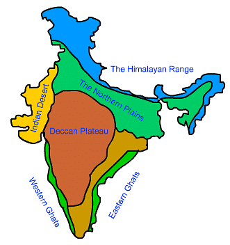 Fig: Physiographic divisions of IndiaThe Coastal Plains: The Peninsular Plateau of India is surrounded by a stretch of narrow coastal plains to its west and east. The Western Coastal Plain is a narrow strip of plain stretching along the Arabian Sea lying to its west and surrounded by the Western Ghats to its east. The northern part of the West Coast is called the Konkan (Mumbai to Goa), the central stretch is called the Kannad while the southern part is called the Malabar Coast. The Eastern Coastal Plain is comparatively wide and level stretch running along the Bay of Bengal lying to its east with the Eastern Ghats rising to its west. It is known as Northern Circar in the north, while its southern part is referred to as the Coromandal Coast.
Ques 2. Where are the Western and the Eastern Ghats situated? Write a small note on each.
Ans. The Western and the Eastern Ghats are situated in the Peninsular Plateau region. The Western Ghats mark the western edge of the Deccan Plateau and lie parallel to the Western Coast. Fig: Western and Eastern ghats of IndiaThe Eastern Ghats mark the eastern edge of the Deccan Plateau. They stretch from the Mahanadi Valley to the Nilgiri Hills in the south. The eastern coastal plain runs to its east. The Western Ghats are continuous and regular and can be crossed only through passes like the Thal, Bhor and the Pal Ghats.
They are comparatively high in elevation (average 900 to 1600 metres). No major river cuts across the Western Ghats. The Eastern Ghats are discontinuous and irregular. They are of relatively lower elevation (average 600 m). They are dissected by rivers draining into the Bay of Bengal.
Ques 3. What is the Great Himalaya? Write two characteristics of it.
Ans. The northernmost range of the Himalayas is known as the Great or Inner Himalayas or the Himadri.
(i) It is the most continuous range consisting of the highest peaks with an average height of 6000 metres. It contains all the prominent Himalayan peaks.
(ii) Its folds are asymmetrical in nature and its core is composed of granite rock. It is always snowbound and contains many glaciers.
Ques 4. Which plateau lies between the Aravali and the Vindhya range? Write a brief note on this plateau.
Ans. The Malwa Plateau lies between the Aravali hills and the Vindhya range. The Aravali hills lie to the west of the plateau and the Vindhya range lies to its south. The part of the peninsular plateau lying to the north of the Narmada river, covering a major area of the Malwa plateau, is known as the Central Highlands.
The Malwa plateau lies in Madhya Pradesh. It is composed of extensive lava flows. There are rolling plains separated by flat-topped hills. The plateau is largely broken in form of ravines near the Chambal Valley in its east.
Ques 5. What do you understand by 'duns'? Where are they situated in our country? Give any two examples of duns.
Ans. The longitudinal valleys lying between Lesser Himalaya and the Shivaliks are known as duns. Dehradun and Kotli Dun are two examples of duns.
Ques 6. Describe 'Bhabar' and 'Terai'.
Ans. Bhabar is pebble dotted formation situated at the base of mountains and plains in the Himalayan region. Terai is a sloping land at the foothills of the Nepal Himalayas. The Terai receives heavy rainfall and is densely forested.
Ques 7. Name any three divisions of Himalayas on the basis of regions from West to East and also write one main feature of each.
Ans. The Himalayas have been divided on the basis of regions from west to east. These divisions have been separated by river valleys.
(i) The part of Himalayas lying between Indus and Sutlej has been traditionally known as Punjab Himalayas. It is also regionally known as Kashmir Himachal Himalaya from west to east respectively.
(ii) The part of Himalayas lying between Sutlej and Kali rivers is known as Kumaon Himalayas.
(iii) The Kali and Tista rivers separated the Nepal Himalayas and the part lying between Tista and Dihang rivers is known as Assam Himalayas.
Ques 8. Why are the Himalayas called young fold mountains?
Ans. The Himalayan mountain is geologically young and structurally fold mountains stretch over the northern parts of India.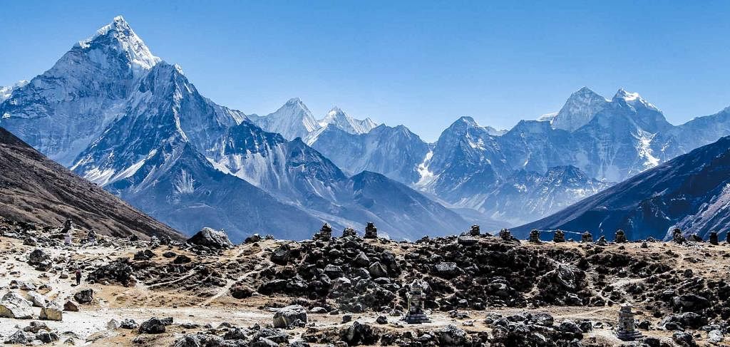 Fig: The Himalayan mountain It was uplifted from the 'Tethys Sea' during the Tertiary period. The whole mountain represents a very youthful topography with high peaks, deep valleys and fast flowing rivers. That is why it is called an young-fold mountain.
Ques 9. The relief of India displays a great physical variation. Explain.
Ans. India is a vast country with varied land forms. It has high mountains, plains, plateaus, islands, deserts etc. This varied large landmass formed during different geological periods which has influenced her relief.
Besides geological formations, a number of processes such as weathering, erosion and deposition have created and modified the relief to its present form. It is, therefore, India displays a great physical variation.
|
53 videos|437 docs|80 tests
|
FAQs on Class 9 Geography Chapter 1 Question Answers - Contemporary India - I
| 1. What are the major physical features of India? |  |
| 2. How do the Himalayas influence the climate of India? | |
| 3. What is the significance of the Indo-Gangetic Plain? | |
| 4. What are the different types of landforms found in the Deccan Plateau? | |
| 5. How does the Thar Desert impact the lifestyle of people living in its region? | |

|
104.7K Views |

|
4.85/5 Rating |

|
Dec 24, 2024 Last updated |

|
Explore Courses for Class 9 exam
|
|
shortcuts and tricks
,video lectures
,past year papers
,Free
,Viva Questions
,MCQs
,Objective type Questions
,Exam
,Previous Year Questions with Solutions
,study material
,Extra Questions
,Sample Paper
,Semester Notes
,Class 9 Geography Chapter 1 Question Answers - Contemporary India - I
,Class 9 Geography Chapter 1 Question Answers - Contemporary India - I
,Important questions
,Summary
,practice quizzes
,mock tests for examination
,ppt
,Class 9 Geography Chapter 1 Question Answers - Contemporary India - I
;


Short Answer Questions - Physical Features of India Free PDF Download
Importance of Short Answer Questions - Physical Features of India
Short Answer Questions - Physical Features of India Notes
Short Answer Questions - Physical Features of India Class 9
Study Short Answer Questions - Physical Features of India on the App
|
© EduRev
|
Education Revolution
|


|


