Short Question Answers: India-Location | Geography Class 11 - Humanities/Arts PDF Download
Q. 1. Which line of latitude passes through the centre of India ?
Ans. Tropic of Cancer 23½° N.
Q. 2. Name the two zones formed by Tropic of Cancer in India.
Ans. Tropical zone and Temperate zone.
Q. 3. What is the total length of coastline of India ?
Ans. 7516.6 km.
Q. 4. Which strait separates India from Sri Lanka ?
Ans. Palk Strait.
Q. 5. Which ocean route links, India with Europe ?
Ans. Suez Canal.
Q. 6. Which is the largest state of India (Area) ?
Ans. Rajasthan.
Q. 7. Which is the smallest state of India ?
Ans. Goa.
Q. 8. Which is the smallest Union Territory in India ?
Ans. Lakshadweep.
Q. 9. Which state of India is surrounded by boundaries of five states ?
Ans. Madhya Pradesh and Karnataka.
Q. 10. How many states are coastal states ?
Ans. Nine states are coastal states: Gujarat, Maharashtra, Karnataka, Goa, Kerala, Tamil Nadu, Andhra Pradesh, Odisha, West Bengal.
Q. 11. How many islands are there in Andaman and Nicobar Islands ?
Ans. 204.
Q. 12. How many islands are there in Lakshadweep Islands ?
Ans. 36.
Q. 13. Name a group of Coral islands.
Ans. Lakshadweep.
Q. 14. What is the total geographical area of India ?
Ans. 31,66,414 km2.
Q. 15. Between which latitudes and longitudes the Indian sub-continent lie ?
Ans. Between 8°N to 37°N latitude and 68°E to 97°E longitudes.
Q. 16. Name the State in India through which the Standard Meridian of India, as well as the Tropic of Cancer, pass covering the longest distance.
Ans. Madhya Pradesh.
Q. 17. What is the East-West and North-South extent of India ?
Ans. East-West extent = 2933 kms. North-South extent = 3214 kms.
Q. 18. Name two towns located on Tropic of Cancer in India.
Ans. Ahmedabad and Jabalpur.
Q. 19. What is a sub-continent ? Explain this with reference to countries lying south of the Himalayan Mountain System in South Central Asia.
Ans. Sub-continent : A sub-continent is a vast independent geographical unit. This land mass is distinctly separated from the main continent. The vastness in size produces a diversity in economic, social and cultural conditions. India is a vast country. It is often described as ‘Indian sub-continent’.
Countries : The Himalayan mountain system acts as a physical barrier separating the Indian subcontinent from the main land of Asia. India, Pakistan, Bangladesh, Nepal and Bhutan, Maldives, Sri Lanka combine together to form a sub-continent. The great mountain wall isolates these countries from Asia.
These are also called ‘SAARC’ countries.
Q. 20. Describe the Westernmost point and Easternmost point of India.
Ans. East-west extent. India has an east-west extent of about 3,000 kms. Its westernmost point lies on a creek in the salty marshes of the Rann of Kutchh.
The Easternmost point lies in the forested hills where the boundaries of Myanmar, China and India meet.
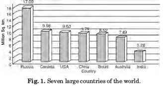
Q. 21. Where does India rank in area among the countries of the world ?
Ans. India ranks seventh in area among the countries of the world. India with an area of 3.2 million sq. kms. occupies 2.4% of the total world area. Russia, Canada, China, U.S.A., Brazil and Australia are larger in size than India. India almost equals Europe, Russia is seven times as large as India and the U.S.A. is thrice as big.
Q. 22. State the passes in N.W. part of India and explain their importance.
Ans. The only way people from outside could get into India were the Khyber Pass, near Safed Koh, and the Hindu Kush mountains and the Bolan pass between the Sulaiman and the Kirthar ranges in the north-west that separated the Indian realm from Afghanistan. It is through these routes that earlier central and west Asian tribes came to India, and later armies of Alexander, Afghan and Persians entered India.
Q. 23. Name the important passes across the lofty Himalayan mountains of the Indian subcontinent.
Ans. The Himalayas act as a physical barrier in the north. There are many passes to cross these lofty mountains such as :
(i) Shipkila pass (along Indo-Tibet Road).
(ii) Karakoram pass (Kashmir).
(iii) Nathula pass (Sikkim).
(iv) Jelep-la-pass (Sikkim).
Q. 24. Name the five countries whose frontiers meet at the northern apex of India.
Ans. On the northern side of India, the boundaries of the following five countries meet together– China, Russia, Tajakistan, Afghanistan and Pakistan. These five countries meet at the apex of the north Indian triangle. This apex, pamir knot is called the roof of the world.
Q. 25. What is the McMohan Line ? What does it signify ?
Ans. McMohan line is the dividing line between India and China. It lies to the east of Bhutan. It extends from Kashmir to Arunachal Pradesh. Beyond it, lies the area of Sinkiang and Tibet. It runs along the crest of the high Himalayas. To the north of this line, lies Tibet. This boundary line runs through a complex mountainous terrain. At its eastern point Myanmar, China and India meet each other. The crests along this form a natural boundary which acts as a watershed and is historically determined.
|
70 videos|289 docs|44 tests
|
FAQs on Short Question Answers: India-Location - Geography Class 11 - Humanities/Arts
| 1. Where is India located? |  |
| 2. Which ocean surrounds India? |  |
| 3. What is the geographical significance of India's location? |  |
| 4. How does India's location impact its monsoon season? |  |
| 5. How does India's location contribute to its biodiversity? |  |


