Worksheet: Maps and Locations - 1 | Worksheets with Solutions for Class 5 PDF Download

Multiple Choice Questions
(i) In the given map, a 1cm square grid represents 50km. What is the approximate distance between Jaunpur and Chapra?
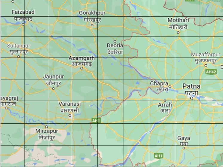
(a) 250 km
(b) 450 km
(c) 350 km
(d) 150 km
(ii) There is a pentagon drawn on a 1 cm square grid. If Mohan is asked to draw the same picture on a 2cm grid. The side of the square is made two times bigger. Does the area of square grids also become two times bigger?
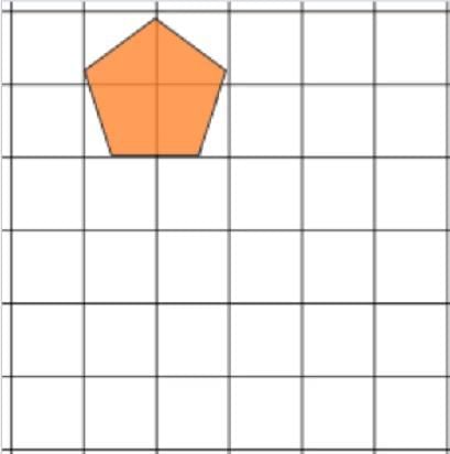
(a) Yes, becomes two times bigger
(b) No, it becomes 4 times bigger
(c) No, it becomes three times bigger
(d) No, it remains the same
c) If the tiger wants to catch the deer, in which direction he should be making the jump?
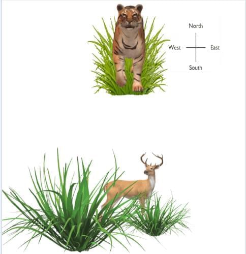
(a) North
(b) South
(c) East
(d) West
Answer the following Questions
(i) 
(ii) Find out the scale used to draw the map using the distance information given.
Places - From Bangalore to Lucknow
Actual distance - 1855 Km
Distance on map - 5.3 cm
(iii) Height of a building is 9 m and this building is represented by 9 cm on a map. What is the scale used for the map?
(iv) If actual distance between two places A and B is 110 km and it is represented on a map by 25 mm. Then the scale used is _____.
Look at the given map of India and answer the questions that follow
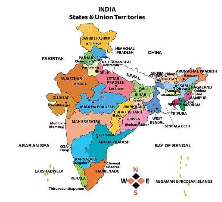
(i) Which State is surrounded by four other states?
(ii) Which state has the largest area?
(iii) Which are the places along the sea coast of South India?
(iv) Mark those states which have the sea on one side.
(v) Name one state which does not have the sea on any side.
(vi) Name 4 Eastern states of India.
(vii) Name 4 South Indian states.
(viii) Which is the capital of Tamil Nadu?
(ix) Sai is going from Tamil Nadu to Punjab. Name the states which fall in between his route.
(x) Harsha is travelling from Delhi to Mumbai (Maharashtra). Name the states which fall in between her route.
You can access the solutions to this worksheet here.
FAQs on Worksheet: Maps and Locations - 1 - Worksheets with Solutions for Class 5
| 1. What is the importance of understanding maps and locations in geography? |  |
| 2. How can one calculate the perimeter of a given shape on a map? | |
| 3. What are the different types of maps commonly used in education? | |
| 4. Why is it important for students to learn about their country’s geography? | |
| 5. What skills can students develop by studying maps and locations? | |


Worksheet: Maps and Locations - 1 | Worksheets with Solutions for Class 5
,past year papers
,Objective type Questions
,ppt
,Summary
,Free
,Worksheet: Maps and Locations - 1 | Worksheets with Solutions for Class 5
,Previous Year Questions with Solutions
,Extra Questions
,Viva Questions
,practice quizzes
,Worksheet: Maps and Locations - 1 | Worksheets with Solutions for Class 5
,mock tests for examination
,Important questions
,Sample Paper
,MCQs
,video lectures
,Semester Notes
,shortcuts and tricks
,Exam
,study material
;


Worksheet: Maps and Locations - 1 Free PDF Download
Importance of Worksheet: Maps and Locations - 1
Worksheet: Maps and Locations - 1 Notes
Worksheet: Maps and Locations - 1 Class 5 Questions
Study Worksheet: Maps and Locations - 1 on the App
|
© EduRev
|
Education Revolution
|


|


within 7 days!