Worksheet: Maps and Locations - 2 | Worksheets with Solutions for Class 5 PDF Download
| Table of contents |
|
| Multiple Choice Question |
|
| Fill in the Blanks |
|
| Find out from the given map. |
|
| Questions & Answers |
|

Multiple Choice Question
Q1. On a map, which direction is opposite to East?
(a) North
(b) South
(c) West
(d) East
Q2. If you move from the top to the bottom of a map, you are moving:
(a) East
(b) West
(c) North
(d) South
Q3. Which of these is used to show exact positions on a map?
(a) Compass
(b) Scale
(c) Grid/Coordinates
(d) Legend
Q4. The symbol on a map that shows directions is called:
(a) Key
(b) Compass
(c) Scale
(d) Grid
Q5. A map scale is used to:
(a) Show direction
(b) Show real distances in smaller form
(c) Show colors
(d) None of these
Fill in the Blanks
Q1. The four main directions are __________, __________, __________, and __________.
Q2. On a map, __________ is usually at the top.
Q3. Moving __________ on a grid means going towards East.
Q4. The __________ number in a coordinate pair shows the column.
Q5. The __________ helps in finding directions on a map.
Q6. A __________ helps to measure real distances in a smaller form.
Find out from the given map.
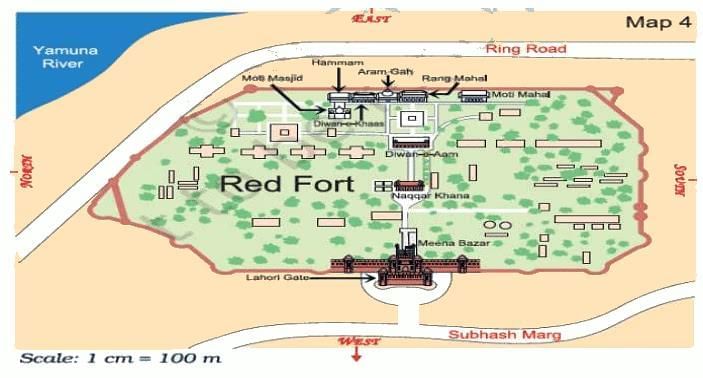
(i) Which of these are nearest to River Yamuna?
(ii) Which is in between the two buildings Hammam and Rang Mahal?
(iii) Which building do you pass while going from Rang Mahal to the Hammam?
(iv) Which building on this map is farthest from Meena Bazar?
Questions & Answers
(i) What is the opposite direction of NORTH?
(ii) What is the opposite direction of EAST?
(iii) What is the opposite direction of SOUTH?
(iv) Northern state is ____________
(v) Eastern state is _____________
(vi) Southern state is ____________
(vii) Distance between two states is 36 cm in the map. If 1 cm = 10 km in the map, what will be the actual distance between two states?
(viii) Distance between two states is 24 cm in the map. If 1 cm = 20 km in the map, what will be the actual distance between two states?
(ix) Distance between two states is 48 cm in the map. If 1 cm = 30 km in the map, what will be the actual distance between two states?
You can access the solutions to this worksheet here.
FAQs on Worksheet: Maps and Locations - 2 - Worksheets with Solutions for Class 5
| 1. What are the different types of maps used in geography? |  |
| 2. How do maps help us understand locations better? | |
| 3. What is the significance of the scale in a map? | |
| 4. Can maps show cultural and historical information? | |
| 5. What role do maps play in environmental studies? | |


shortcuts and tricks
,Free
,Viva Questions
,Semester Notes
,ppt
,mock tests for examination
,practice quizzes
,Objective type Questions
,Exam
,study material
,Worksheet: Maps and Locations - 2 | Worksheets with Solutions for Class 5
,Worksheet: Maps and Locations - 2 | Worksheets with Solutions for Class 5
,Sample Paper
,MCQs
,Important questions
,Extra Questions
,Worksheet: Maps and Locations - 2 | Worksheets with Solutions for Class 5
,past year papers
,Previous Year Questions with Solutions
,Summary
,video lectures
;


Worksheet: Maps and Locations - 2 Free PDF Download
Importance of Worksheet: Maps and Locations - 2
Worksheet: Maps and Locations - 2 Notes
Worksheet: Maps and Locations - 2 Class 5 Questions
Study Worksheet: Maps and Locations - 2 on the App
|
© EduRev
|
Education Revolution
|


|


within 7 days!