Worksheet: Maps and Map Reading | Footprints Class 6: Book Solutions, Notes & Worksheets PDF Download

Q1: Multiple Choice Questions (MCQs)
(i) What does a globe represent?
(a) Two-dimensional model of the Earth
(b) Three-dimensional model of the Earth
(c) Map of the continents
(ii) Which type of map is designed to show specific themes like population density?
(a) Political map
(b) Physical map
(c) Thematic map
(iii) What is the purpose of the legend or index on a map?
(a) Show directions
(b) Give the key to symbols
(c) Provide the title
(iv) Why are sketches drawn quickly and not to scale?
(a) To save time
(b) To give a rough idea
(c) To show accurate distances
(v) What is the main function of the north line on a map?
(a) Show boundaries
(b) Determine directions
(c) Provide a key
Q2: Fill in the blanks
(i) Maps are drawings of the Earth's surface on a ____________.
(ii) Plans are drawn to ____________.
(iii) The scale of a map is the ratio between the map distance and the actual ____________ distance.
(iv) A book of maps is called an ____________.
(v) Sketches are useful for giving a ____________ idea of an area.
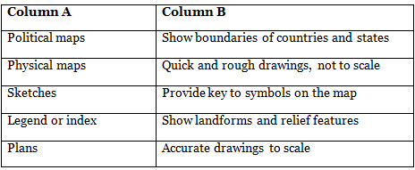
Q3: Match the Column (In a Table)
Q4: True/False
(i) A globe is the best tool to study small areas like villages.
(ii) Sketches are drawn to scale.
(iii) Plans are inaccurate drawings.
(iv) The north line helps determine directions on a map.
(v) Political maps focus on themes like population density.
You can access the solutions to this worksheet here.
|
65 videos|127 docs|25 tests
|
FAQs on Worksheet: Maps and Map Reading - Footprints Class 6: Book Solutions, Notes & Worksheets
| 1. What are maps used for? |  |
| 2. How are maps created? | |
| 3. What are the different types of maps? | |
| 4. How can I read a map effectively? | |
| 5. Where can I find digital maps? | |


MCQs
,Exam
,Worksheet: Maps and Map Reading | Footprints Class 6: Book Solutions
,Summary
,ppt
,Notes & Worksheets
,study material
,Important questions
,practice quizzes
,Notes & Worksheets
,shortcuts and tricks
,Notes & Worksheets
,Extra Questions
,Free
,Viva Questions
,Worksheet: Maps and Map Reading | Footprints Class 6: Book Solutions
,Worksheet: Maps and Map Reading | Footprints Class 6: Book Solutions
,mock tests for examination
,Objective type Questions
,video lectures
,Previous Year Questions with Solutions
,past year papers
,Semester Notes
,Sample Paper
;


Worksheet: Maps and Map Reading Free PDF Download
Importance of Worksheet: Maps and Map Reading
Worksheet: Maps and Map Reading Notes
Worksheet: Maps and Map Reading Class 6 Questions
Study Worksheet: Maps and Map Reading on the App
|
© EduRev
|
Education Revolution
|


|


