Worksheet Solutions: Locating Places on the Earth | Worksheets with Solutions for Class 6 PDF Download
| Table of contents |
|
| Multiple Choice Questions (MCQs) |
|
| Fill in the Blanks |
|
| True or False |
|
| Match the Following |
|

Multiple Choice Questions (MCQs)
Q1: What is a map primarily used for?
a) Showing where things are and how to get to them
b) Displaying random drawings
c) Creating confusion about directions
d) None of the above
Ans: a) Showing where things are and how to get to them
A map is primarily used to indicate the location of places and provide directions. The other options do not accurately represent the function of a map.
Q2: What is the purpose of a scale on a map?
a) To measure the weight of the map
b) To represent distances on the ground accurately
c) To confuse readers about distance
d) To decorate the map
Ans: b) To represent distances on the ground accurately
The scale on a map is used to translate distances on the map to real-world distances. Other options misrepresent the purpose of a scale.
Q3: What do the cardinal directions on a map represent?
a) Intermediate directions
b) Primary directions
c) Religious symbols
d) None of the above
Ans: b) Primary directions
The cardinal directions (North, South, East, West) are the primary directions used for navigation. The other options do not accurately define cardinal directions.
Q4: What do symbols represent on a map?
a) Actual buildings and elements
b) Fictional characters
c) Random drawings
d) None of the above
Ans: a) Actual buildings and elements
Symbols on a map are designed to represent real-world features such as buildings and landmarks. Other options do not reflect the purpose of map symbols.
Q5: What is the purpose of an atlas?
a) To confuse readers about geography
b) To provide a collection of maps
c) To display fictional locations
d) None of the above
Ans: b) To provide a collection of maps
An atlas is a book or collection of maps, which is its primary purpose. The other options do not accurately describe the function of an atlas.
Fill in the Blanks
Q1: A map is like a __________ guide.Ans: treasure
A map is often compared to a treasure guide because it helps locate important places, similar to how treasure maps lead to hidden treasures.
Q2: Symbols on a map represent different kinds of __________.
Ans: buildings
Maps utilize symbols to depict various buildings and structures, making it easier for users to understand the layout of an area.
Q3: The scale on a map helps in representing distances on the __________.
Ans: ground
The scale is crucial as it translates map measurements to actual ground distances, enabling accurate navigation and understanding of space.
Q4: An atlas is a book or collection of __________.
Ans: maps
An atlas is designed to provide a comprehensive collection of maps, which can include geographical, political, and thematic maps.
Q5: Symbols are used on maps to represent features when there is limited space for __________.
Ans: drawings
Maps often have limited space, so symbols are used instead of detailed drawings to efficiently represent various features.
True or False
Q1: Maps primarily show where things are and how to get to them. (True/False)Ans: True
Maps are essential tools that provide information about locations and navigation routes, making this statement true.
Q2: Symbols on a map do not represent any real elements. (True/False)
Ans: False
Symbols on maps are designed to represent real-world elements, such as landmarks and geographical features, indicating this statement is false.
Q3: The scale on a map is not necessary for representing distances accurately. (True/False)
Ans: False
The scale on a map is crucial for accurately measuring distances, making this statement false.
Q4: An atlas is a collection of maps. (True/False)
Ans: True
An atlas is indeed a compilation of maps, confirming that this statement is true.
Q5: Symbols on a map are used to represent features when there is limited space. (True/False)
Ans: True
Using symbols allows mapmakers to efficiently represent various features in limited space, validating this statement as true.
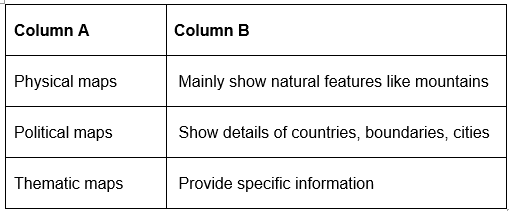
Match the Following
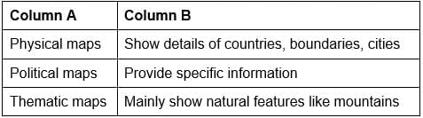
Ans:
FAQs on Worksheet Solutions: Locating Places on the Earth - Worksheets with Solutions for Class 6
| 1. How can we locate places on the Earth? |  |
| 2. What is the significance of using latitude and longitude to locate places on the Earth? | |
| 3. Can you explain the difference between latitude and longitude? | |
| 4. How do GPS devices use latitude and longitude to provide accurate location information? | |
| 5. What are some common tools or methods used to determine latitude and longitude? | |


video lectures
,Objective type Questions
,Worksheet Solutions: Locating Places on the Earth | Worksheets with Solutions for Class 6
,mock tests for examination
,practice quizzes
,Summary
,MCQs
,Viva Questions
,Semester Notes
,Sample Paper
,Extra Questions
,Important questions
,ppt
,shortcuts and tricks
,past year papers
,Worksheet Solutions: Locating Places on the Earth | Worksheets with Solutions for Class 6
,Previous Year Questions with Solutions
,Free
,study material
,Exam
,Worksheet Solutions: Locating Places on the Earth | Worksheets with Solutions for Class 6
;


Worksheet Solutions: Locating Places on the Earth Free PDF Download
Importance of Worksheet Solutions: Locating Places on the Earth
Worksheet Solutions: Locating Places on the Earth Notes
Worksheet Solutions: Locating Places on the Earth Class 6 Questions
Study Worksheet Solutions: Locating Places on the Earth on the App
|
© EduRev
|
Education Revolution
|


|


within 7 days!