Worksheet Solutions: Maps and Locations - 1 | Worksheets with Solutions for Class 5 PDF Download

Multiple Choice Questions
(i) In the given map, a 1cm square grid represents 50km. What is the approximate distance between Jaunpur and Chapra?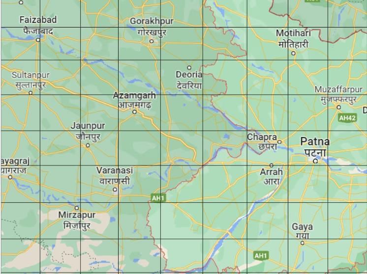
(a) 250 km
(b) 450 km
(c) 350 km
(d) 150 km
Ans: (a) 250 km
To calculate the distance between Jaunpur and Chapra, we followed these steps:
- Grid Measurement: The map is divided into 1 cm grid squares, and the scale tells us that each 1 cm on the map equals 50 kilometers on the ground.
- Estimate the Distance: By counting the number of grid squares between Jaunpur and Chapra, the distance is estimated to be around 5 cm.
- Convert to Real Distance: Since each centimeter on the map represents 50 kilometers, we multiply the 5 cm by 50 kilometers:
5 cm × 50 km/cm = 250 km
Therefore, the approximate distance between Jaunpur and Chapra is 250 km.
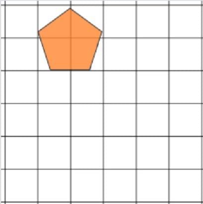
(ii) There is a pentagon drawn on a 1 cm square grid. If Mohan is asked to draw the same picture on a 2cm grid. The side of the square is made two times bigger. Does the area of square grids also become two times bigger?
(a) Yes, becomes two times bigger
(b) No, it becomes 4 times bigger
(c) No, it becomes three times bigger
(d) No, it remains the same
Ans: (b) No, it becomes 4 times bigger
The area of a square is calculated using the formula: Area = side × side.
Original Grid (1 cm):
- Area = 1cm×1cm=1 square cm
New Grid (2 cm):
- Area = cm
When the side of the square becomes two times bigger, the area becomes four times bigger, not two times. Therefore, the correct answer is (b) No, it becomes 4 times bigger.
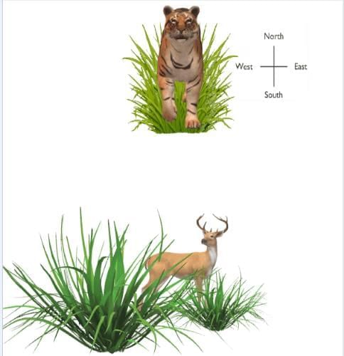
c) If the tiger wants to catch the deer, in which direction he should be making the jump?
(a) North
(b) South
(c) East
(d) West
Ans: (b) South
Based on the image and the compass directions provided, the tiger is positioned to the north of the deer. If the tiger wants to catch the deer, it should jump south.
So, Option b is correct.
Answer the following Questions
(i) 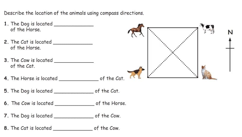
Ans: 1. The Dog is located south of the Horse.
2. The Cat is located southeast of the Horse.
3. The Cow is located north of the Cat.
4. The Horse is located northwest of the Cat.
5. The Dog is located west of the Cat.
6. The Cow is located east of the Horse.
7. The Dog is located southwest of the Cow.
8. The Cat is located south of the Cow.
(ii) Find out the scale used to draw the map using the distance information given.
Places - From Bengaluru to Lucknow
Actual distance - 1855 Km
Distance on map - 5.3 cm
Ans: Actual distance =1855 km
Distance on map =5.3 cm
1 cm = 1855 km / 5.3
= 1855km / 1 x 10/53
= 18550 km/53
∴ 1 cm = 350 km
(iii) Height of a building is 9 m and this building is represented by 9 cm on a map. What is the scale used for the map?
Ans: Given: The height of the building is 9m.
9m is represented by 9cm on the map.
We know that 1m = 100cm
therefore,
9m : 9cm ⇒ 900cm : 9cm
Scale used ⇒ 100:1
(iv) If actual distance between two places A and B is 110 km and it is represented on a map by 25 mm. Then the scale used is _____.
Ans: We know that
Scale of map = Size drawn on map / Actual size = 25mm / 110km
25mm / 110000000mm
1/440000
So, If actual distance between two places A and B is 110 km and it is represented on a map by 25 mm. Then the scale used is 1 : 4400000
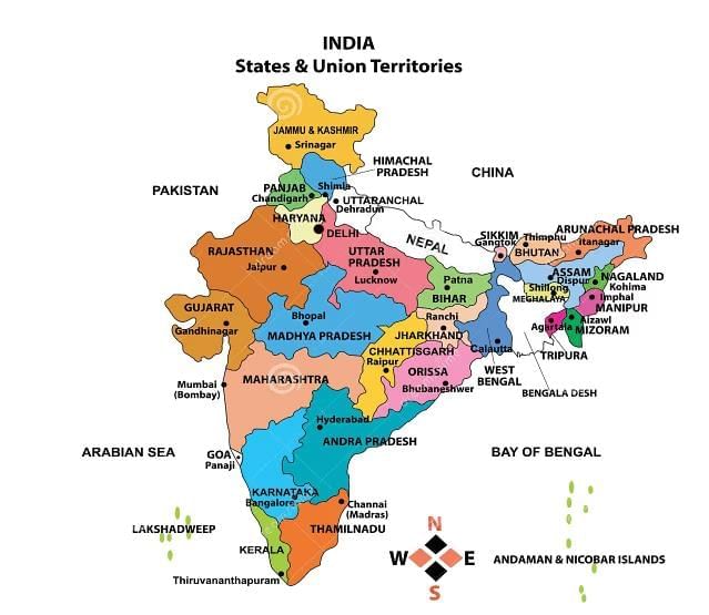
(i) Which State is surrounded by four other states?
Ans: Haryana. It is surrounded by Punjab, Himachal Pradesh, Uttarakhand, and Uttar Pradesh.
(ii) Which state has the largest area?
Ans: Rajasthan. It is the largest state in India by area.
(iii) Which are the places along the sea coast of South India?
Ans:
- Chennai (Tamil Nadu)
- Thiruvananthapuram (Kerala)
- Mangalore (Karnataka)
- Panaji (Goa)
(v) Mark those states which have the sea on one side.
Ans:
- Gujarat
- Maharashtra
- Karnataka
- Kerala
- Tamil Nadu
- Andhra Pradesh
- Odisha
- West Bengal
- Goa
(vi) Name one state which does not have the sea on any side.
Ans: Madhya Pradesh. It is a landlocked state with no coastline.
(vii) Name 4 Eastern states of India.
Ans:
- Arunachal Pradesh
- Assam
- Sikkim
- Mizoram
(viii) Name 4 South Indian states.
Ans:
- Tamil Nadu
- Kerala
- Karnataka
- Andhra Pradesh
(ix) Which is the capital of Tamil Nadu?
Ans: Chennai. It is the capital city of Tamil Nadu.
(x) Sai is going from Tamil Nadu to Punjab. Name the states which fall in between his route.
Ans: The states from South to North are:
- Tamil Nadu
- Karnataka
- Maharashtra
- Madhya Pradesh
- Uttar Pradesh
- Haryana
- Punjab
(xi) Harsha is travelling from Delhi to Mumbai (Maharashtra). Name the states which fall in between her route.
Ans: The states from North to West are:
- Delhi
- Haryana
- Rajasthan
- Gujarat
- Maharashtra
FAQs on Worksheet Solutions: Maps and Locations - 1 - Worksheets with Solutions for Class 5
| 1. What is the formula to calculate the perimeter of a rectangle? |  |
| 2. How can I find the perimeter of a triangle? | |
| 3. What units are commonly used to express perimeter? | |
| 4. How does the shape of a polygon affect its perimeter? | |
| 5. Can the perimeter of a circle be calculated, and if so, what is it called? | |


practice quizzes
,Previous Year Questions with Solutions
,video lectures
,Worksheet Solutions: Maps and Locations - 1 | Worksheets with Solutions for Class 5
,Extra Questions
,Sample Paper
,Worksheet Solutions: Maps and Locations - 1 | Worksheets with Solutions for Class 5
,past year papers
,study material
,shortcuts and tricks
,Semester Notes
,Important questions
,Objective type Questions
,Summary
,Viva Questions
,ppt
,Worksheet Solutions: Maps and Locations - 1 | Worksheets with Solutions for Class 5
,Exam
,mock tests for examination
,MCQs
,Free
;


Worksheet Solutions: Maps and Locations - 1 Free PDF Download
Importance of Worksheet Solutions: Maps and Locations - 1
Worksheet Solutions: Maps and Locations - 1 Notes
Worksheet Solutions: Maps and Locations - 1 Class 5 Questions
Study Worksheet Solutions: Maps and Locations - 1 on the App
|
© EduRev
|
Education Revolution
|


|


