Worksheet Solutions: Maps and Map Reading | Footprints Class 6: Book Solutions, Notes & Worksheets PDF Download

Q1: Multiple Choice Questions (MCQs)
(i) What does a globe represent?
(a) Two-dimensional model of the Earth
(b) Three-dimensional model of the Earth
(c) Map of the continents
Ans: (b)
"A globe represents a three-dimensional model of the Earth."
(ii) Which type of map is designed to show specific themes like population density?
(a) Political map
(b) Physical map
(c) Thematic map
Ans: (c)
"Thematic maps: These are especially designed to show a particular theme."
(iii) What is the purpose of the legend or index on a map?
(a) Show directions
(b) Give the key to symbols
(c) Provide the title
Ans: (b)
"The index or legend of a map gives the key to the symbols used on the map."
(iv) Why are sketches drawn quickly and not to scale?
(a) To save time
(b) To give a rough idea
(c) To show accurate distances
Ans: (b)
"Sketches can be drawn quickly to give a rough idea of the layout of a certain area or to show the route and locations of places."
(v) What is the main function of the north line on a map?
(a) Show boundaries
(b) Determine directions
(c) Provide a key
Ans: (b)
"The north line helps us to determine the three other main directions on the map."
Q2: Fill in the blanks
(i) Maps are drawings of the Earth's surface on a ____________.
Ans: flat surface
(ii) Plans are drawn to ____________.
Ans: scale
(iii) The scale of a map is the ratio between the map distance and the actual ____________ distance.
Ans: ground
(iv) A book of maps is called an ____________.
Ans: atlas
(v) Sketches are useful for giving a ____________ idea of an area.
Ans: rough
Q3: Match the Column (In a Table)
Ans: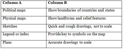
Q4: True/False
(i) A globe is the best tool to study small areas like villages.
Ans: False
A globe cannot show details of smaller areas.
(ii) Sketches are drawn to scale.
Ans: False
Sketches are rough and not drawn to scale.
(iii) Plans are inaccurate drawings.
Ans: False
Plans are accurate drawings that show more detail for a smaller area.
(iv) The north line helps determine directions on a map.
Ans: True
The north line helps in determining directions.
(v) Political maps focus on themes like population density.
Ans: False
Political maps show boundaries, not themes like population density.
|
65 videos|127 docs|25 tests
|
FAQs on Worksheet Solutions: Maps and Map Reading - Footprints Class 6: Book Solutions, Notes & Worksheets
| 1. What are some key skills required for map reading? |  |
| 2. How can maps be used for navigation? | |
| 3. What are some common symbols found on maps? | |
| 4. What is the importance of scale on a map? | |
| 5. How can one determine the cardinal directions on a map? | |


Objective type Questions
,Previous Year Questions with Solutions
,Notes & Worksheets
,study material
,Sample Paper
,Viva Questions
,mock tests for examination
,practice quizzes
,ppt
,Notes & Worksheets
,Worksheet Solutions: Maps and Map Reading | Footprints Class 6: Book Solutions
,Worksheet Solutions: Maps and Map Reading | Footprints Class 6: Book Solutions
,Important questions
,past year papers
,Worksheet Solutions: Maps and Map Reading | Footprints Class 6: Book Solutions
,Exam
,Extra Questions
,Semester Notes
,Free
,shortcuts and tricks
,Notes & Worksheets
,MCQs
,Summary
,video lectures
;


Worksheet Solutions: Maps and Map Reading Free PDF Download
Importance of Worksheet Solutions: Maps and Map Reading
Worksheet Solutions: Maps and Map Reading Notes
Worksheet Solutions: Maps and Map Reading Class 6 Questions
Study Worksheet Solutions: Maps and Map Reading on the App
|
© EduRev
|
Education Revolution
|


|


