Class 9 Geography Chapter 3 Notes - Drainage
| Table of contents |
|
| Introduction |
|
| Drainage Systems in India |
|
| Lakes |
|
| Role of Rivers in the Economy |
|
| River Pollution |
|
| Difficult Words |
|

Introduction
The term drainage refers to the system of rivers in a given area. When you look at a physical map, you can see how small streams from various directions merge to form the main river, which eventually flows into a larger body of water like a lake, sea, or ocean. The region serviced by a single river system is called a drainage basin. If you examine a map closely, you will find that any elevated region, such as a mountain or hill, separates two drainage basins. This elevated area is known as a water divide.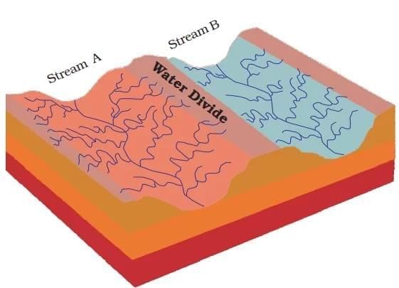 Water Divide
Drainage Systems in India
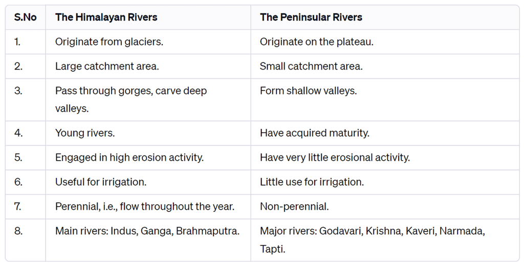
The drainage systems of India are mainly shaped by the large landforms of the subcontinent. Accordingly, the Indian rivers can be divided into two main categories:
- The Himalayan Rivers
- The Peninsular Rivers
These rivers start from two different regions—Himalayan rivers begin in the mountains of the north, while Peninsular rivers begin in the southern part of India. They are quite different from each other.
Himalayan Rivers:
- These rivers flow all year round. This is because they get water from both rainfall and melting snow from the mountains.
- Two main rivers from the Himalayas are the Indus and the Brahmaputra. They start from the north of the mountain ranges and cut deep valleys called gorges.
- These rivers travel long distances from the mountains to the sea.
- In the upper part of their journey, they erode a lot of soil and rocks and carry large amounts of silt and sand.
- In the middle and lower parts, they form features like meanders (curvy paths), oxbow lakes, and floodplains.
- They also form big deltas near the sea.
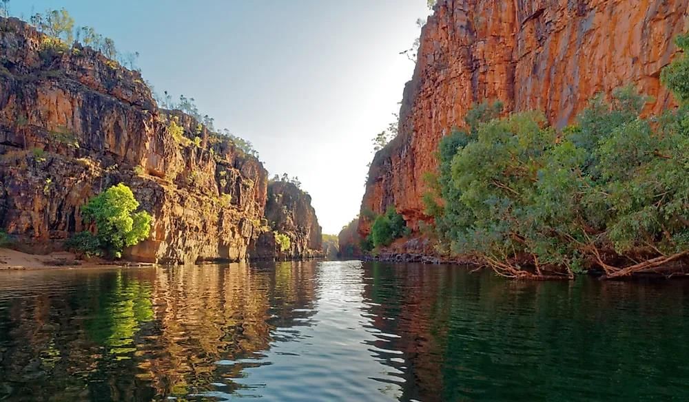 Gorge
Gorge
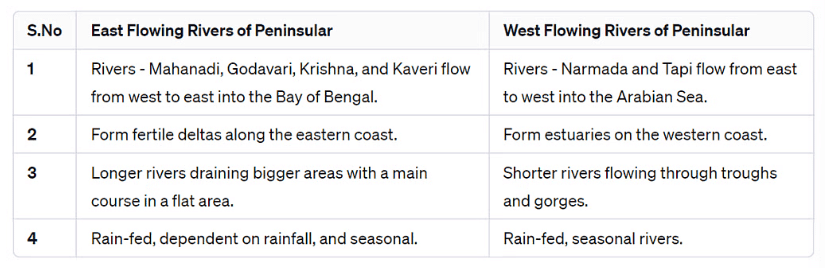
Peninsular Rivers:
- Most of these rivers depend on rain, so they are seasonal—they have less water during the dry season.
- They don’t travel as far as the Himalayan rivers and have shorter and shallower paths.
- Some Peninsular rivers start from the Central Highlands and flow westward.
- But most Peninsular rivers begin in the Western Ghats and flow eastward into the Bay of Bengal.
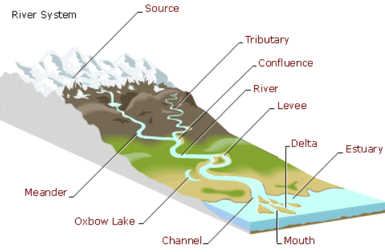 Some features made by Rivers
To summarise, the table is given below -

The Himalayan Rivers
The main rivers of the Himalayas are the Indus, Ganga, and Brahmaputra. These rivers are very long and have many smaller rivers flowing into them. These smaller rivers are called tributaries. Together, a main river and its tributaries form a river system.
1. The Indus River System
- The Indus River starts in Tibet, near Lake Mansarowar.
- It flows westward and enters India through Ladakh.
- In Ladakh, the river forms a beautiful gorge (deep valley).
- In the Kashmir region, the Indus is joined by several tributaries: the Zaskar, the Nubra, the Shyok and the Hunza.
- The river then flows through Baltistan and Gilgit.
- It comes out of the mountains at Attock.
- Later, five important rivers join the Indus near Mithankot in Pakistan: The Satluj, the Beas, the Ravi, the Chenab and the Jhelum.
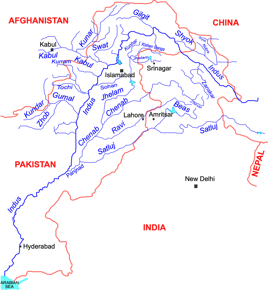 Indus River System
 - After this, the Indus flows southwards and reaches the Arabian Sea, east of Karachi.
- The Indus plain (the area around the river) has a very gentle slope.
- The total length of the Indus is about 2900 km, making it one of the longest rivers in the world.
- About one-third of the Indus River Basin lies in India, covering: Ladakh, Jammu and Kashmir, Himachal Pradesh and Punjab.
- The rest of the basin is located in Pakistan.
2. The Ganga River System
- The source of the Ganga, called the ‘Bhagirathi,’ is fed by the Gangotri Glacier and meets the Alaknanda at Devprayag in Uttarakhand. It is only after Devprayag that the water body is known as Ganga. At Haridwar, the Ganga flows from the mountains to the plains.
- The Ganga is joined by several tributaries from the Himalayas, including the Yamuna, Ghaghara, Gandak, and Kosi. The Yamuna rises from the Yamunotri Glacier in the Himalayas and joins the Ganga at Allahabad. The Ghaghara, Gandak, and Kosi also originate in the Nepal Himalaya.
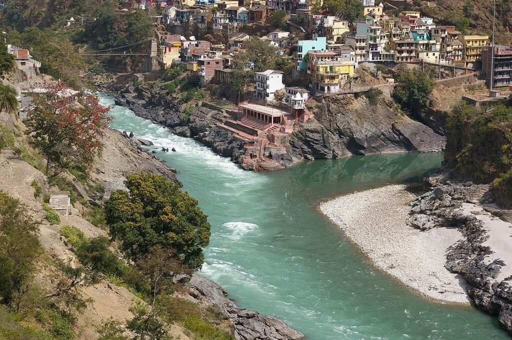 Confluence of Bhagirathi and Alaknanda at Devaprayag
 - Main tributaries from the peninsular uplands include the Chambal, the Betwa, and the Son.
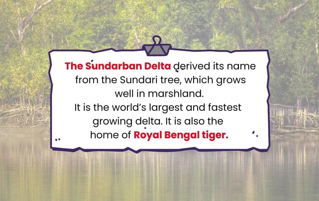
- The Ganga flows east to Farakka in West Bengal, the northernmost point of the Ganga delta. Here, it splits; the Bhagirathi-Hooghly flows south through the deltaic plains to the Bay of Bengal. The main river continues south into Bangladesh, where it meets the Brahmaputra. Further downstream, it is called the Meghna and ultimately flows into the Bay of Bengal. The delta formed by these rivers is known as the Sunderban Delta, which is vital for its biodiversity and ecological significance.
- The Ganga River is more than 2500 km long.
- Ambala is a place that lies on the water divide between the Indus and Ganga river systems. This means it separates the flow of water into two different river systems.
- The plains from Ambala to the Sunderbans are about 1800 km long.
- But the total slope or height drop in this long stretch is only about 300 metres.
- That means the land slopes down very gently—just 1 metre drop in height every 6 km.
- Because of this gentle slope, the Ganga river forms large meanders (big curves or bends in the river).
3. The Brahmaputra River System
- The Brahmaputra rises in Tibet, east of Mansarovar Lake. It is slightly longer than the Indus and flows east alongside the Himalayas.
- Upon reaching Namcha Barwa (7757 m), it makes a ‘U’ turn and enters India in Arunachal Pradesh through a gorge, where it is known as the Dihang. It is joined by the Dibang, Lohit, and many other tributaries, forming the Brahmaputra in Assam.
- In India, it flows through a high rainfall area, carrying a large volume of water and significant amounts of silt. The Brahmaputra has a braided channel throughout Assam, creating many river islands, with Majuli being the largest inhabited river island in the world.
- During the monsoon season, the river can overflow its banks, causing extensive flooding in Assam and Bangladesh. The riverbed accumulates large amounts of silt, which can raise the riverbed and shift its channel frequently.

The Peninsular Rivers
The Peninsular drainage system is older than the Himalayan drainage system. This is shown by the wide, mostly flat valleys and the well-developed rivers. Peninsular rivers have a fixed path, do not meander, have small drainage areas, and flow non-continuously. The main water divide in Peninsular India is formed by the Western Ghats, which stretch from north to south near the western coast. Most major rivers in this region, such as the Mahanadi, the Godavari, the Krishna, and the Kaveri, flow eastwards into the Bay of Bengal and form deltas at their mouths.
Additionally, there are many small streams flowing west of the Western Ghats. The Narmada and Tapi are the only long rivers that flow westward and create esturies. The drainage basins of these rivers are generally smaller compared to those of the Himalayan rivers.
1. The Narmada Basin
The Narmada River starts from the Amarkantak hills in Madhya Pradesh. It flows westward through a rift valley, which was formed because of cracks (faults) in the Earth’s surface.
- As it moves towards the sea, the Narmada creates many beautiful spots.
- One famous place is the ‘Marble Rocks’ near Jabalpur, where the river flows through a deep valley.
- Another is the ‘Dhuadhar Falls’, where the river falls down over steep rocks, making a loud sound and a scenic view.
The river’s tributaries (smaller rivers that join it) are quite short and most of them join the Narmada at right angles. The Narmada river basin includes parts of Madhya Pradesh and Gujarat.
2. The Tapi Basin
The Tapi River starts in the Satpura ranges in the Betul district of Madhya Pradesh. It flows through a rift valley, just like the Narmada, but it is much shorter in length. The Tapi basin covers parts of Madhya Pradesh, Gujarat, and Maharashtra. The coastal plains between the Western Ghats and the Arabian Sea are very narrow, which is why the coastal rivers in this region are short. Some of the main west-flowing rivers include the Sabarmati, Mahi, Bharathpuzha, and Periyar.
3. The Godavari Basin
The Godavari is the largest river system in the peninsula, rising from the slopes of the Western Ghats in the Nasik district of Maharashtra. It is around 1,500 km long, and due to its size, it is often called the Dakshin Ganga. The Godavari's drainage basin is the largest among the peninsular rivers, covering parts of:
- Maharashtra (about 50 percent of the basin area)
- Madhya Pradesh
- Odisha
- Andhra Pradesh
The Godavari is joined by several tributaries, including the Purna, the Wardha, the Pranhita, the Manjra, the Wainganga, and the Penganga. It ultimately drains into the Bay of Bengal.
4. The Mahanadi Basin
The Mahanadi rises in the highlands of Chhattisgarh near Sihawa and flows through Odisha to reach the Bay of Bengal. Fifty-three percent of its drainage basin is in Maharashtra and Chhattisgarh, while 47 percent is in Odisha. Its length is approximately 860 km.
5. The Krishna Basin
The Krishna is the second-largest east-flowing river in the peninsula, rising near Mahabaleshwar in the Sahyadri range. It flows for about 1,400 km and has several tributaries, including the Tungabhadra, the Koyana, the Ghatprabha, the Musi, and the Bhima.
6. The Kaveri Basin
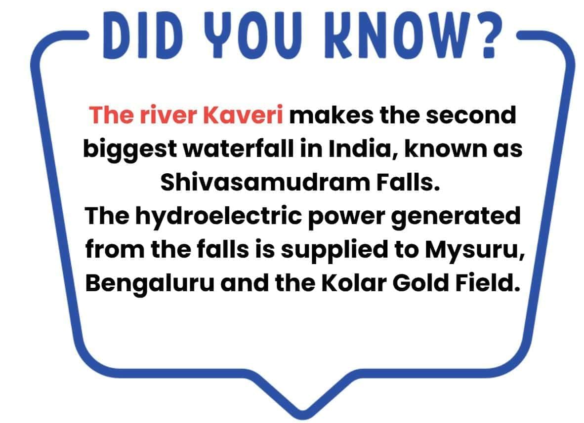
The Kaveri River starts in the Brahmagri range of the Western Ghats and flows into the Bay of Bengal south of Cuddalore in Tamil Nadu. The total length of the river is about 760 km. Its main tributaries are the Amravati, Bhavani, Hemavati, and Kabini rivers. The Kaveri Basin covers parts of Karnataka, Kerala, and Tamil Nadu.
Besides these major rivers, there are some smaller rivers that flow towards the east. Some well-known examples are the Damoder, Brahmani, Baitarni, and Subarnrekha rivers.
Lakes
You might have heard of the Kashmir valley and the famous Dal Lake, where people enjoy houseboats and shikaras (small boats). These things attract thousands of tourists every year. Lakes make tourist places more attractive and fun to visit. But lakes are not just for tourists—they are also very useful to people in many other ways.
- India has many lakes. They are different in size and how they were formed.
- Most lakes are permanent, meaning they have water all year.
- Some lakes have water only in the rainy season, especially in dry areas (semi-arid regions). These are found in inland drainage basins.
- Some lakes were formed by glaciers and ice sheets.
- Others were made by wind, rivers, or even human activities.
- Sometimes, a meandering river (a river with many curves) cuts off a bend, which later becomes an ox-bow lake.
- In coastal areas, spits and bars (sand formations) can block water and form lagoons. Examples: the Chilika Lake, the Pulicat Lake, the Kolleru Lake
- Lakes in inland drainage areas can be seasonal (have water only in some seasons). Example: Sambhar Lake in Rajasthan is a salt water lake, and its water is used to make salt.
- Most freshwater lakes are in the Himalayas.
- They were formed when glaciers dug a hole (a basin), which later filled with melted snow.
- Example:
(i) Wular Lake in Jammu and Kashmir is a tectonic lake (formed due to movement in the Earth’s crust). It is the largest freshwater lake in India.
(ii) Other famous freshwater lakes: Dal Lake, Bhimtal, Nainital, Loktak, and Barapani. - When we build dams on rivers to produce hydroelectric (hydel) power, lakes are also formed.
- Example: Guru Gobind Sagar Lake (formed by the Bhakra Nangal Dam).
Importance of Lakes
- Lakes are essential for regulating rivers, preventing floods during heavy rainfall, and maintaining a steady water flow in dry periods.
- They provide sources of hydropower and freshwater, and help moderate the climate.
- Lakes support diverse ecosystems, enhance natural beauty, and offer recreational activities, making them vital and multifunctional parts of the environment.
Role of Rivers in the Economy
Rivers have always played an important role in human life. The water from rivers is a natural resource that people need for many daily activities. That’s why people have been settling near rivers since ancient times, and many of those old settlements have now grown into big cities.
Rivers are also very useful for farming (irrigation), transportation (navigation), and producing electricity (hydro-power). This is especially important for a country like India, where most people depend on farming for their livelihood.
River Pollution
- The increasing demand for water from rivers due to domestic, municipal, industrial, and agricultural needs is impacting water quality.
- This demand leads to more water being taken from rivers, which decreases their flow.
- At the same time, untreated sewage and industrial waste are being discharged into these rivers.
- This not only deteriorates water quality but also reduces the river's ability to cleanse itself.
- For instance, when there is enough water flow, the Ganga can dilute and manage pollution within 20 km of large cities.
- However, growing urban and industrial activities obstruct this natural process, resulting in higher pollution levels in many rivers.
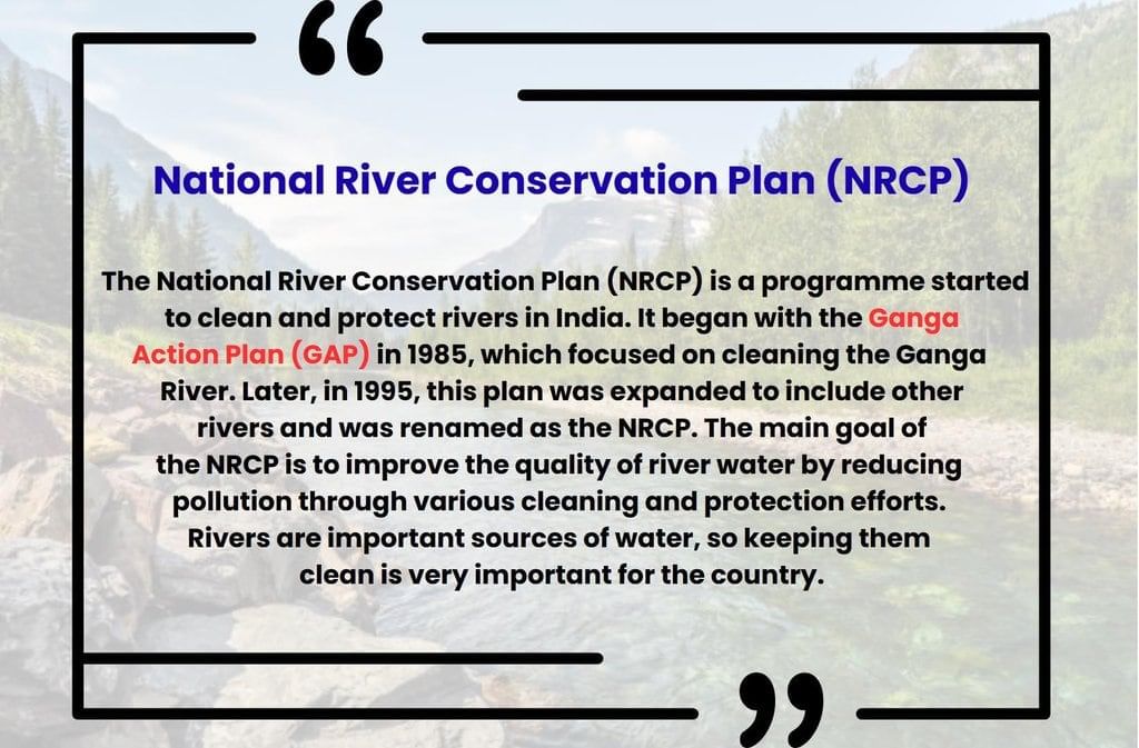
- The rising pollution levels have prompted the initiation of various action plans aimed at cleaning the rivers.
For a detailed understanding of this chapter, check the video below.
Difficult Words
- Drainage Basin: The area drained by a single river system where precipitation collects and drains off into a common outlet, such as into a river, bay, or other body of water.
- Tributary: A river or stream flowing into a larger river or lake.
- Water Divide: An elevated area, such as a mountain or upland, that separates two drainage basins.
- Rift Valley: A large elongated depression with steep walls formed by the downward displacement of a block of the earth's surface between nearly parallel faults or fault systems.
- Braided Channel: A network of river channels separated by small, often temporary, islands called braid bars. These typically form in rivers with high sediment loads and strong currents.
- Riverine Island: An island formed by the course of a river. Majuli in the Brahmaputra River is an example of such an island.
- Alluvial Soil: Soil deposited by rivers. It is typically fertile and good for agriculture.
- Peninsular Plateau: A plateau in India making up the majority of the southern part of the country. It is bordered by two mountain ranges, the Eastern and Western Ghats.
- Sundarban Delta: The large delta formed at the mouth of the Ganges and Brahmaputra River systems. It is noted for its wide mangrove forests and is home to the Royal Bengal Tiger.
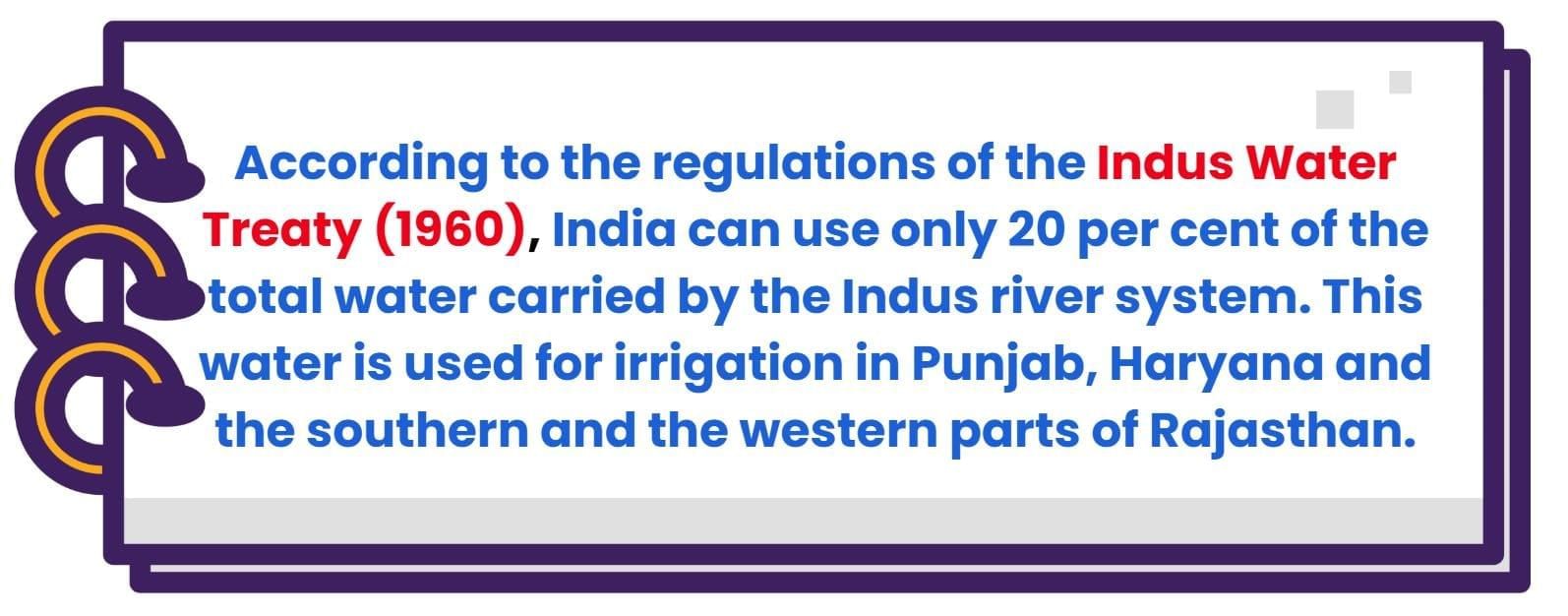
- Indus Water Treaty: A water-distribution treaty between India and Pakistan, brokered by the World Bank, to use the water available in the Indus River and its tributaries.
|
63 videos|525 docs|78 tests
|
FAQs on Class 9 Geography Chapter 3 Notes - Drainage
| 1. What are the main features of the Himalayan drainage system in India? |  |
| 2. How does the Peninsular drainage system differ from the Himalayan drainage system? | |
| 3. What is the significance of lakes in India's drainage system? | |
| 4. How do rivers contribute to the economy of India? | |
| 5. What are the major causes of river pollution in India? | |


Class 9 Geography Chapter 3 Notes - Drainage
,Previous Year Questions with Solutions
,past year papers
,Semester Notes
,Viva Questions
,Objective type Questions
,shortcuts and tricks
,MCQs
,Free
,Class 9 Geography Chapter 3 Notes - Drainage
,Exam
,Class 9 Geography Chapter 3 Notes - Drainage
,mock tests for examination
,Extra Questions
,Summary
,practice quizzes
,ppt
,Sample Paper
,video lectures
,Important questions
,study material
;


Detailed Chapter Notes - Drainage Free PDF Download
Importance of Detailed Chapter Notes - Drainage
Detailed Chapter Notes - Drainage
Detailed Chapter Notes - Drainage Class 9 Questions
Study Detailed Chapter Notes - Drainage on the App
|
© EduRev
|
Education Revolution
|


|


