Worksheet Solutions: Globes and Maps - 1

Q1: Multiple Choice Questions (MCQs)
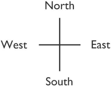
(i) North, South, East and West are four major
(a) lines
(b) signs
(c) directions
(d) None of these
Ans: (c)
Explanation: North, East, South and West are the four cardinal directions. They are often shown by the initials N, E, S and W. East and West are at right angles to North and South. When moving clockwise from North, you reach East, and West is directly opposite East.
(ii) The South Pole is
(a) 90° S
(b) 90° N
(c) 0° N
(d) None of these
Ans: (a)
Explanation: Latitude is measured in degrees north or south of the Equator (0°). The North Pole is at 90° N and the South Pole is at 90° S. Therefore, the South Pole is at 90° S.
(iii) The total number of meridians is
(a) 180
(b) 360
(c) 90
(d) None of these
Ans: (b)
Explanation: Meridians (longitudes) are measured around the Earth from 0° at the Prime Meridian up to 180° east and 180° west. Because each degree of longitude can be counted around the full 360° circle, there are 360 meridians in total. (By contrast, there are 181 parallels of latitude, including the Equator.)
(iv) North-east lies between
(a) South and East
(b) North and West
(c) North and East
(d) None of these
Ans: (c)
Explanation: North-east (NE) is the direction halfway between North and East. On a compass, it lies at an angle of 45° measured clockwise from North.
(v) The Tropic of Cancer is located at
(a) 23½° S
(b) 23½° N
(c) 25½° W
(d) None of these
Ans: (b)
Explanation: The Tropic of Cancer lies at about 23½° north of the Equator. It marks the most northerly latitude at which the Sun can be directly overhead at noon.
Q2: Fill in the blanks
(i) A globe does not give_________ information.
Ans: A globe does not give detailed or specific geographic information.
(ii) An _______ is an imaginary line on which the earth rotates.
Ans: An axis is an imaginary line on which the Earth rotates.
(iii) Including the Equator there are __________ latitudes.
Ans: Including the Equator, there are 181 latitudes.
(d) Signs, symbols and colours are called __________ of the map.
Ans: Signs, symbols and colours are called conventions of the map.
(iv) The imaginary lines drawn parallel to the Equator are known as parallels of _________.
Ans: The imaginary lines drawn parallel to the Equator are known as parallels of latitude.
Q3: Match the following
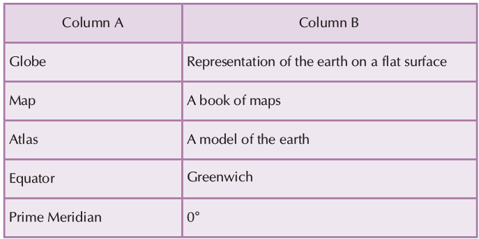
Ans:
- Globe - Model of earth
A globe is a spherical model of Earth, of some other celestial body, or of the celestial sphere. - Map - a representation of earth on a flat surface.
A map is a symbolic representation of selected characteristics of a place, usually drawn on a flat surface. - Atlas - a book of maps
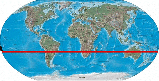
An atlas is a book or collection of maps. Many atlases also contain facts and history about certain places. - Equator - 0 degrees
The Equator is the invisible line that runs around the centre of the Earth at 0 degrees latitude. - Prime meridian - Greenwich
The Prime Meridian is a geographical reference line that passes through the Royal Observatory, Greenwich, in London, England.
Q4: True & False
(i) Meridians are straight vertical lines on the globe.
Ans: False
Explanation: Meridians are semi-circles that run from the North Pole to the South Pole. They are not straight vertical lines on a globe but curved lines that meet at the poles.
(ii) The Arctic Circle is in the Southern Hemisphere.
Ans: False
Explanation: The Arctic Circle is located in the Northern Hemisphere. Its counterpart in the Southern Hemisphere is the Antarctic Circle.
(iii) All places on the same longitude have the same local time.
Ans: True
Explanation: Places located on the same meridian (longitude) share the same local solar time because they are directly north or south of each other along that meridian.
(iv) The Prime Meridian is located at 0° longitude.
Ans: True
Explanation: The Prime Meridian, defined as 0° longitude, passes through Greenwich, England, and serves as the reference line for measuring longitudes east and west.
(v) There are 180 lines of latitude in total.
Ans: False
Explanation: Latitudes run from 90° North to 90° South. Including the Equator (0° latitude), there are 181 parallels of latitude in total.
Q5: Give one word answer to the following
(i) What is a book of maps called?
Ans: An atlas is a book or collection of maps. Many atlases also include factual information and indexes to help find places.
(ii) What is the shape of the Earth?
Ans: The Earth is an oblate spheroid (a slightly flattened sphere). From space, it looks round, but it is slightly flattened at the poles and bulges at the Equator.
(iii) What is the ratio between the distance on the ground and the distance on the map known as?
Ans: This ratio is called the map scale. It shows how distances on the map relate to real distances on the ground.
(iv) What is the model of an earth called?
Ans: A spherical model of the Earth is called a globe. Globes give the most accurate view of Earth's shape and the arrangement of continents and oceans.
Q6: Short answer type questions
(i) Which are the four major directions?
Ans: The four major (cardinal) directions are North, East, South and West. They are shown by N, E, S and W.
(ii) Which are the important latitudes?
Ans: The five important circles of latitude are the Arctic Circle, the Tropic of Cancer, the Equator, the Tropic of Capricorn and the Antarctic Circle.
(iii) What is the main feature of a map?
Ans: Main features of a map include its scale, symbols and the grid. The scale shows how map distances relate to actual ground distances.
Q7: Long answer type questions
(i) Write the features and limitations of a globe.
Ans: A globe is a spherical model of the Earth. It represents the shape, relative positions of continents and oceans, and directions very accurately because it is three-dimensional and does not distort shapes as flat maps do.
The limitations of a globe are:
- A globe cannot show very small areas or provide detailed information about a town or district.
- A globe is too small to show the actual size of areas; it is only a scaled model.
- Features such as roads, small rivers or land use types cannot be shown clearly on a globe.
(ii) What do you mean by Northern Hemisphere and Southern Hemisphere?
Ans: The Earth is divided by the Equator into two halves. Places north of the Equator are in the Northern Hemisphere; places south of the Equator are in the Southern Hemisphere. The Northern Hemisphere includes most of North America, Europe and mainland Asia.
(iii) Write short notes on:
(a) Longitude
Ans: Longitude measures how far east or west a place is from the Prime Meridian (0°). Meridians are imaginary lines running from the North Pole to the South Pole; they are used to find local time and position east or west on the globe.
(b) Eastern and Western Hemispheres
Ans: The Earth is divided into the Eastern Hemisphere and the Western Hemisphere by the Prime Meridian (0°) and the 180° meridian. The Western Hemisphere lies west of the Prime Meridian and east of the 180° meridian; the Eastern Hemisphere is the opposite half.
(c) International Date Line
Ans: The International Date Line is an imaginary line roughly along the 180° meridian in the Pacific Ocean. It was agreed in 1884 and serves as the place where the date changes by one day when it is crossed from east to west or west to east.
FAQs on Worksheet Solutions: Globes and Maps - 1
| 1. What is the difference between a globe and a map for Class 5 Social Studies? |  |
| 2. How do you read latitude and longitude lines on a globe or map? | |
| 3. Why are some maps stretched or distorted compared to what we see on a globe? | |
| 4. What are the main types of maps and when would you use each one? | |
| 5. How do map symbols, colours, and legends help you understand map information? | |


