Revision Notes - Interior of the Earth


The earth's radius is about 6,378 km.. As no one can reach the center of the earth, most of our knowledge about the interior of the earth is largely based on estimates and inferences.
 Earth's Center
Sources of Information about the Interior
Information about the interior of the Earth comes from two broad sources:
- Direct sources
- Indirect sources
Direct Sources
Direct sources are those by which material originating from the Earth's interior is obtained for laboratory study.
- Surface rocks collected from outcrops and rocks obtained from mining operations provide direct samples. Example: Gold mines in South Africa reach depths of about 3-4 km.
- Deep drilling projects aim to penetrate the crust and sample deeper layers. Major international efforts include the Deep Ocean Drilling Project and the Integrated Ocean Drilling Project.
- Going beyond 3-4 km depth in mines is difficult because temperature becomes very high.
- The deepest borehole so far, at Kola in the Arctic region, has reached a depth of about 12 km.
- Volcanic eruptions provide molten material (magma) that, when erupted, becomes lava and solid rock available for analysis.
- Analyses of materials obtained from these sources across different depths supply important information on composition, texture, temperature and pressure conditions in the crust and upper mantle.
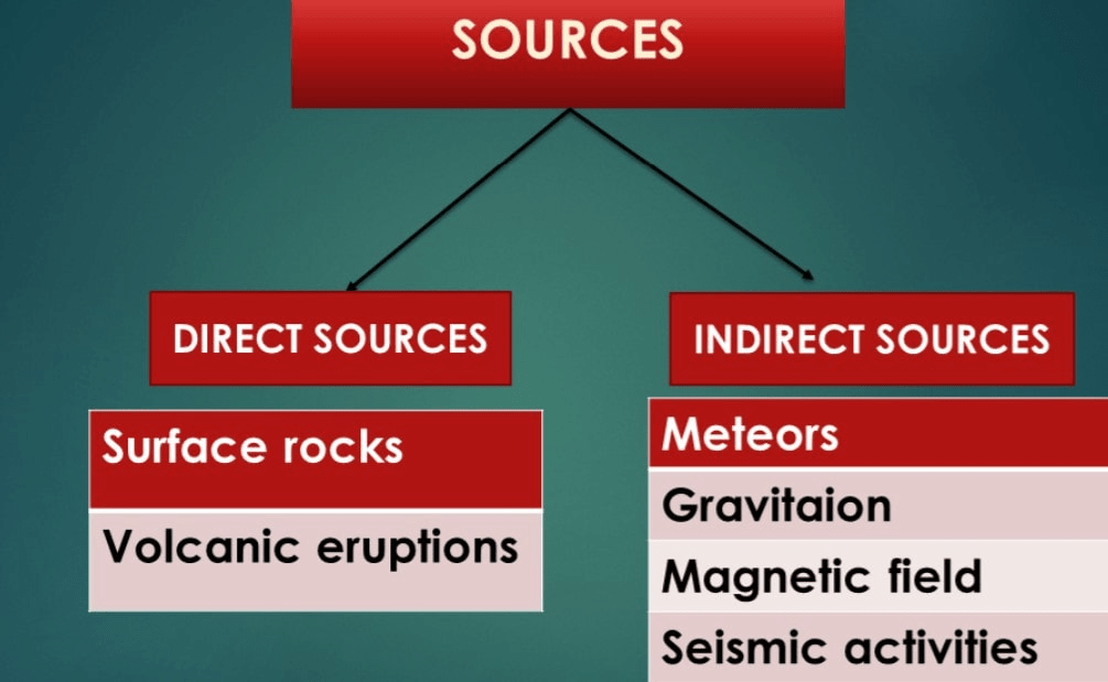
Indirect Sources
Indirect sources provide information about the Earth's interior without directly sampling it. These include meteors, gravity and magnetic surveys, and seismic studies.
- Mining and drilling show that temperature and pressure generally increase with depth; density of material also increases with depth.
- By combining these observations with the known total size of the Earth, scientists estimate temperature, pressure and density values at various depths.
- Meteors sometimes supply material similar in composition to Earth; although meteor material is not from Earth's interior, it helps infer early solar-system composition and therefore similarities with terrestrial material.
- Gravitation varies across the surface. Gravity is slightly greater near the poles and less at the equator because of the Earth's shape and distribution of mass. Deviations from expected gravity values are called gravity anomalies and indicate variations in mass distribution within the crust.
- Magnetic surveys reveal the distribution of magnetic minerals in the crust and provide clues to subsurface composition and structure.
- Seismic activity (earthquakes) is the most important indirect source. The way seismic waves travel through Earth allows scientists to infer the internal layered structure, physical states (solid or liquid), and discontinuities.
Earthquake
It is the shaking of the Earth caused by the sudden release of energy that generates waves travelling in all directions.
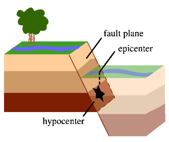
An earthquake is a natural event caused by a sudden release of accumulated strain energy in the crust. This energy release usually occurs along a fault, a fracture in crustal rocks across which movement has taken place.
- Rocks on either side of a fault are pressed by overlying strata and often remain locked by friction despite forces attempting to move them.
- When the stress overcomes friction, rock blocks slip abruptly, releasing energy in the form of seismic waves.
- The point within the Earth where energy is released is called the focus or hypocentre. The point on the surface directly above the focus is the epicentre, which experiences the waves first.
Try yourself: Which one of the following is a direct source of the information about the interior of the Earth?
Why does the Earth Shake?
- The release of energy occurs along the fault line.
- Rocks along the fault tend to move in opposite directions; overlying strata press them together and friction locks them.
- When forces overcome friction, blocks deform and slide past each other, releasing energy.
- Energy is released as waves that travel in all directions.
- The point where energy is released is the focus/hypocentre; the point directly above it on the surface is the epicentre.
Earthquake Waves
- Most natural earthquakes occur within the lithosphere (to depths of about 200 km).
- Seismic waves are recorded by instruments called seismographs.
- There are two principal categories of seismic waves: body waves (travel through Earth's interior) and surface waves (travel along the surface).
- Body waves originate at the focus and interact with surface rocks to generate surface waves.
- Wave velocity depends on the density and elastic properties of the material: the denser and more rigid the material, the higher the velocity. Waves also change direction when they reflect or refract at material boundaries.
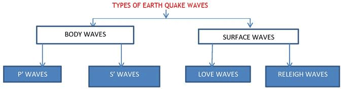
Body Waves: P and S Waves
Body waves are of two kinds: P-waves and S-waves.
- P-waves (primary waves): move fastest and arrive first at seismic stations. They are compressional waves similar to sound waves, and they travel through gases, liquids and solids. P-waves vibrate parallel to the direction of propagation, causing alternating compression and expansion in the material.
- S-waves (secondary waves): arrive after P-waves and are transverse waves. S-waves vibrate perpendicular to the direction of propagation (in a vertical plane), producing troughs and crests in the material. A crucial property is that S-waves can travel only through solids; they do not pass through liquids.
- The difference in behaviour of P- and S-waves helped to reveal the presence of a liquid outer core (S-waves are not transmitted through it) and a solid inner core (inferred from P-wave behaviour).
- Surface waves generated by interaction of body waves with near-surface layers are generally the most destructive because they produce large amplitudes and long durations of shaking.
The Emergence of the Shadow Zone
- Seismic waves are observed at seismographs around the globe, but certain regions do not receive particular waves; these are called shadow zones.
- A zone between 105° and 145° from the epicentre is the shadow zone for both P and S waves (though S-waves are absent beyond 105°).
- S-waves are not recorded beyond 105° from the epicentre; hence, their shadow zone is much larger and covers more than 40% of the Earth's surface.
- The existence and size of shadow zones provide strong evidence for the layered structure and the physical state (solid/liquid) of deep Earth regions.
Types of Earthquakes
- Tectonic earthquakes are the most common and result from movement along faults.
- Volcanic earthquakes are associated with magma movement and eruptions and occur around active volcanoes.
- Collapse earthquakes are minor tremors caused by the collapse of underground mine roofs in areas of intense mining.
- Explosion earthquakes result from large chemical or nuclear blasts and resemble natural tremors in seismic records.
- Reservoir-induced earthquakes occur after the impoundment of large reservoirs when the added load and water infiltration trigger seismicity.
Measuring Earthquakes
- Earthquakes are quantified either by magnitude (a measure of energy released) or by intensity (observed effects and damage).
- The magnitude scale is the Richter scale; it expresses magnitude in absolute numbers roughly from 0-10.
- The intensity scale commonly used is the Mercalli intensity scale, which ranges from 1-12 and describes observed damage and human perception.
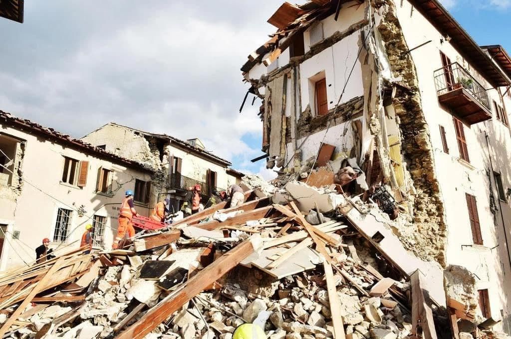
Effects of Earthquake
Earthquakes are natural hazards with several immediate effects. The main hazardous effects include:
- Ground shaking
- Differential ground settlement
- Land and mudslides
- Soil liquefaction
- Ground lurching
- Avalanches
- Ground displacement
- Floods from dam and levee failures
- Fires
- Structural collapse
- Falling objects
- Tsunami (if the epicentre is under the ocean and magnitude sufficiently large)
The first six items above affect landforms, while others pose immediate danger to life and property. Tsunamis are waves generated by earthquake tremors and are not earthquakes themselves. Earthquake shaking lasts only seconds to minutes, but if magnitude exceeds about 5 on the Richter scale, effects can be devastating.
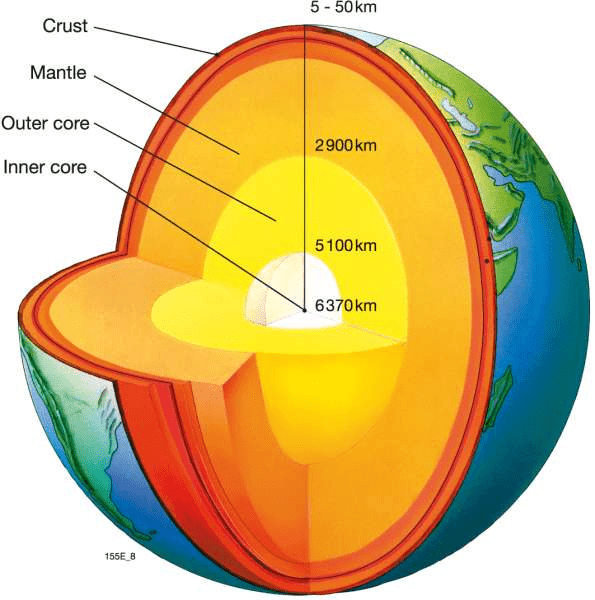
Structure of the Earth
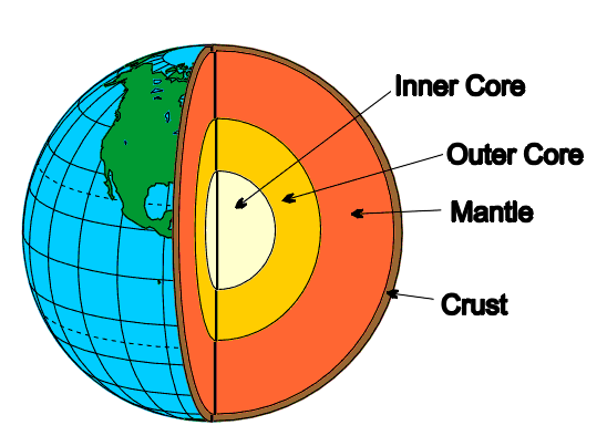
The Crust
- The crust is the outermost solid shell of the Earth and is brittle in nature.
- Crustal thickness varies: the oceanic crust is thinner and the continental crust is thicker.
- Mean thickness values: oceanic crust about 5 km; continental crust about 30 km. In mountain regions such as the Himalaya the crust can be as thick as 70 km.
- Oceanic crust is largely composed of basalt with mean density about 2.7 g/cm³. Some statements refer to crustal rock densities around 3 g/cm³ for heavier rock types.
The Mantle
- The mantle lies below the crust (below the Moho's discontinuity) and extends to a depth of about 2,900 km.
- The upper mantle includes a mechanically weaker zone called the asthenosphere (from Greek astheno = weak), extending to roughly ≈ 400 km depth; it is the main source region of magma that may reach the surface.
- The mantle material has higher density than the crust; sample values used for the upper mantle are about 3.4 g/cm³.
- The lithosphere consists of the crust plus the uppermost rigid mantle and has variable thickness, roughly 10-200 km depending on tectonic setting.
- The lower mantle extends beneath the asthenosphere and is generally solid owing to high pressure.
The Core
- The boundary between mantle and core is at about 2,900 km depth.
- The outer core is in a liquid state, while the inner core is solid.
- Estimated densities rise from about 5 g/cm³ at the mantle-core boundary to around 13 g/cm³ near the Earth's centre (at roughly 6,300 km from the surface to centre values).
- The core is composed mainly of heavy metallic elements, primarily iron and nickel; this is often referred to as the nife (Ni-Fe) layer.
Try yourself: The innermost layer of the earth is?
Volcanoes and Volcanic Landforms
A volcano is a place where gases, ashes, and/or molten rock material (lava) escape to the ground.
- A volcano is termed active if it is currently erupting or has erupted in the recent geological past.
- The mantle's weaker zone, the asthenosphere, contains molten or partially molten material known as magma. When magma reaches the surface it is called lava.
- Material ejected includes lava flows, pyroclastic debris, volcanic bombs, ash, dust, and gases such as sulphur compounds and minor amounts of chlorine, hydrogen and argon.
- Volcanoes are classified by eruption style and the form produced at the surface. Major types include shield, composite (strato), caldera-forming, flood basalt provinces, and mid-ocean ridge volcanoes.
Shield Volcanoes
- Shield volcanoes are broad, gently sloping landforms built primarily by fluid basaltic lava flows.
- They are the largest volcanoes by area; the Hawaiian volcanoes are classic examples.
- Because the lava is very fluid when erupted, these volcanoes are not steep and are usually characterised by non-explosive effusive eruptions unless water enters the vent.
- Eruptive fountains can build small cinder cones at vents, but the dominant morphology is broad, shield-like.
Composite Volcanoes
- Composite volcanoes erupt more viscous and cooler lavas than basalts, often producing explosive eruptions.
- Large quantities of pyroclastic material and ash are emitted and accumulate in layers, producing steep-sided volcanoes made of alternating lava and pyroclast deposits.
- Composite volcanoes commonly produce explosive events that can be highly hazardous.
- Large flood basalt events, by contrast, produce vast horizontal lava flows rather than steep composite cones; the Deccan Traps in India are an example of an extensive flood basalt province.
Calderas
- Caldera-forming eruptions are extremely explosive; instead of building tall cones they can evacuate a large magma chamber, causing the overlying ground to collapse and form a caldera.
- These indicate large, shallow magma chambers and very high explosivity.
Flood Basalt Provinces
- These are regions where highly fluid lava poured out over large areas producing thick, extensive basalt layers. Individual flows can extend for many kilometres and stack into great thickness.
Mid-Ocean Ridge Volcanoes
- Mid-ocean ridges form an extensive submarine volcanic system more than 70,000 km long across the ocean basins.
- The ridge crests experience frequent eruptions producing new oceanic crust at divergent plate boundaries.
Volcanic Landforms
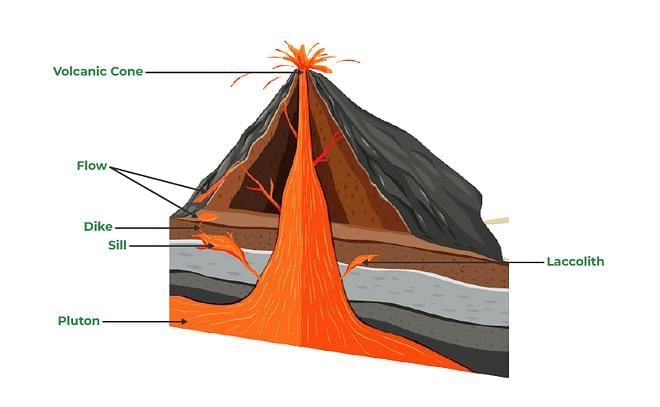
Intrusive Forms
- The lava that is released during volcanic eruptions on cooling develops into igneous rocks.
- The cooling may take place either on reaching the surface or also while the lava is still in the crustal portion.
- Depending on the location of the cooling of the lava, igneous rocks are classified as volcanic rocks (cooling at the surface) and plutonic rocks (cooling in the crust).
- The lava that cools within the crustal portions assumes different forms. These forms are called intrusive forms.
Batholiths
- A large body of magmatic material that cools in the deeper depth of the crust develops in the form of large domes.
- They appear on the surface only after the denudational processes remove the overlying materials.
- They cover large areas, and at times, assume depth that may be several km. These are granitic bodies.
- Batholiths are the cooled portion of magma chambers.
Lacoliths
- These are large dome-shaped intrusive bodies with a level base and connected by a pipe-like conduit from below.
- It resembles the surface volcanic domes of the composite volcanoes, only these are located at deeper depths.
- It can be regarded as the localized source of lava that finds its way to the surface.
- The Karnataka plateau is spotted with domal hills of granite rocks.
- Most of these, now exfoliated, are examples of laccoliths or batholiths.
Lopolith, Phacolith, and Sills
- As and when the lava moves upwards, a portion of the same may tend to move in a horizontal direction wherever it finds a weak plane.
- It may get rested in different forms. In case it develops into a saucer shape, concave to the sky body, it is called lopolith.
- A wavy mass of intrusive rocks, at times, is found at the base of synclines or at the top of anticline in the folded igneous country. Such wavy materials have a definite conduit to source beneath in the form of magma chambers (subsequently developed as batholiths). These are called the phacoliths.
- The near horizontal bodies of the intrusive igneous rocks are called sill or sheet, depending on the thickness of the material. The thinner ones are called sheets while the thick horizontal deposits are called sills.
Dykes
- When the lava makes its way through cracks and the fissures developed in the land, it solidifies almost perpendicular to the ground.
- It gets cooled in the same position to develop a wall-like structure. Such structures are called dykes.
- These are the most commonly found intrusive forms in the western Maharashtra area.
- These are considered the feeders for the eruptions that led to the development of the Deccan traps.
Some Solved Questions
Q.1. What are the effects of propagation of earthquake waves on the rock mass through which they travel?
Ans: Earthquake waves are basically of two types: body waves and surface waves.
- Body waves are generated due to the release of energy at the focus and move in all directions travelling through the body of the Earth. The body waves interact with the surface rocks and generate a new set of waves called surface waves.
- Surface waves move along the surface. The velocity of waves changes as they travel through materials with different densities. The denser the material, the higher the velocity.
- The direction of vibrations of S-waves is perpendicular to the wave direction in the vertical plane; hence they create troughs and crests in the material through which they pass. Surface waves are considered to be the most damaging waves.
- Seismographs located at any distance within 105° from the epicentre record the arrival of both P- and S-waves. Seismographs located beyond approximately 145° from the epicentre may record P-waves but not S-waves.
- A zone between about 105° and 145° from the epicentre is identified as the shadow zone for P-waves; the entire zone beyond about 105° does not receive S-waves. The shadow zone of S-waves is much larger than that of P-waves and covers a substantial portion of the Earth's surface.
Q.2. What do you understand by intrusive forms? Briefly describe various intrusive forms.
Ans: The lava that cools within the crustal portions assumes different forms. These forms are called intrusive forms. Important intrusive forms are described below:
- Batholiths: Large bodies of magmatic material that cool at considerable depths and develop as large dome-like masses; they are the cooled portions of magma chambers and may become exposed after long erosion.
- Lacoliths: Dome-shaped intrusive bodies with a flat base connected by a pipe-like conduit; they resemble surface volcanic domes but are emplaced at depth.
- Lopolith: A saucer-shaped concave-up intrusive body formed when magma spreads along weak horizontal planes.
- Phacolith: A wavy mass of intrusive rock found at the base of synclines or the top of anticlines in folded terrains; these have conduits to deeper magma chambers.
- Sills: Near-horizontal bodies of intrusive igneous rock; thin ones are called sheets while thicker near-horizontal deposits are called sills.
- Dykes: Vertical or steeply inclined wall-like intrusive bodies formed when magma solidifies in cracks and fissures; they often act as feeders for surface eruptions.
FAQs on Revision Notes - Interior of the Earth
| 1. What are the main layers of Earth's interior and how deep does each one go? |  |
| 2. How do scientists know what's inside Earth if we've never dug that deep? | |
| 3. Why does the inner core stay solid even though it's hotter than the outer core? | |
| 4. What's the difference between the lithosphere and the mantle in Earth's interior? | |
| 5. What are the discontinuities in Earth's interior and why do they matter? | |