Earth - Basics, Latitudes and Longitudes


Longitudes and Latitudes
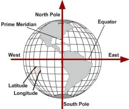
Longitude and latitude are the two angular co-ordinate systems used to locate any place on the Earth's surface. They form a grid of imaginary lines - meridians (longitudes) and parallels (latitudes) - that together give the geographic position of a place.
Longitude
- Longitude is the angular distance measured east or west along the Equator from the Prime (First) Meridian.
- The Prime Meridian is designated 0° and passes through the Royal Observatory at Greenwich near London, England.
- Longitudes are measured from 0° to 180° east and from 0° to 180° west.
- Longitudes determine local time in relation to Greenwich Mean Time (G.M.T.) or World Time.
Latitude
- Latitude of a place is the angular distance north or south of the Equator measured along a meridian. The Equator is given the value of 0°.
- Latitude values range from 0° at the Equator to 90° N at the North Pole and 90° S at the South Pole.
- Because the Earth is slightly flattened at the poles, the linear distance represented by 1° of latitude varies slightly with latitude: the distance per degree is a little smaller at the Equator and a little larger near the poles.
- Examples of linear distance for 1° of latitude as commonly used in geography: at the Equator it is about 68.704 miles, at 45° it is about 69.054 miles, and at the poles about 69.407 miles. The average value often used is 69 miles (111 km). (1 mile = 1.607 km as used here.)
Important Parallels of Latitude
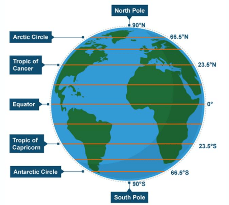
Besides the Equator (0°) and the poles (90°N and 90°S), the commonly referenced parallels are:
- Tropic of Cancer - approximately 23½° N.
- Tropic of Capricorn - approximately 23½° S.
- Arctic Circle - approximately 66½° N.
- Antarctic Circle - approximately 66½° S.
 Parallels of latitude
Important Meridians of Longitude
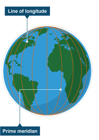
Prime Meridian (0°) - the reference meridian for measuring longitude. All longitudes are expressed as degrees east or west of the Prime Meridian at Greenwich.
International Date Line - an imaginary line running generally along the 180th meridian from the North Pole to the South Pole. It separates two consecutive calendar dates: crossing it from west to east subtracts a day, and crossing from east to west adds a day.
Rotation
- The Earth rotates about its axis from west to east.
- One complete rotation takes approximately 24 hours, producing the sequence of day and night.
- The boundary between the illuminated and the dark half of the Earth is called the circle of illumination.
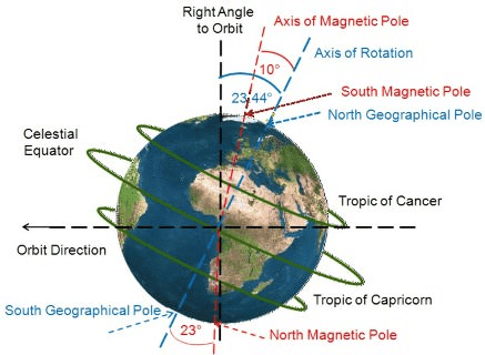
- The Earth's rotational axis is tilted at an angle of about 23.5° to the normal to the orbital plane; equivalently, it makes an angle of 66.5° with the plane of the orbit (the orbital plane is the plane in which the Earth revolves around the Sun).
Revolution
- The Earth's movement around the Sun in its orbit is called revolution.
- One revolution takes approximately 365¼ days, which constitutes one year.
- Because the fractional day (about 6 hours) accumulates each year, an extra day is added every fourth year forming a leap year of 366 days; this extra day is added to February making it 29 days in a leap year.
 Revolution of the Earth and Seasons
Time and Longitude
- One hour of time equals 15° of longitude, because 360° of rotation are completed in 24 hours (360° ÷ 24 = 15° per hour).
- Consequently, 1° of longitude corresponds to 4 minutes of time (60 minutes ÷ 15 = 4 minutes).
- Since the Earth rotates from west to east, when one travels eastwards local time advances and when one travels westwards local time is retarded.
- If Greenwich Mean Time (G.M.T.) is known, local time at a place can be found by adding (if east of Greenwich) or subtracting (if west of Greenwich) the time difference corresponding to the longitudinal difference.
Example (method): to find local time at a place whose longitude is 75°E when GMT is 12:00 noon, calculate the time difference as \\(75° ÷ 15°\\) = \\(5\\) hours; local time = GMT + 5 hours = 17:00 (5:00 pm).
Standard Time
- Following the International Meridian Conference of 1884, many countries adopted a single standard time for the whole country based on a chosen meridian (standard meridian).
- Indian Standard Time (I.S.T.) is based on the local time of the meridian at 82°30′ E (the Indian Standard Meridian), which passes near Allahabad (Prayagraj). The numerical meridian is often shown or illustrated; the relevant image is placed below.

International Date Line
- The line roughly follows the 180th meridian and was designated as the International Date Line at the International Meridian Conference held in Washington D.C. in 1884.
- Counting from the Greenwich Meridian, the date immediately east of this line is one day ahead of the date immediately west of the line.
Try yourself: Which imaginary boundary marks the division between two consecutive calendar days?
The Solar System
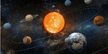
- The Solar System consists of the Sun, eight planets, their moons, dwarf planets (for example Pluto), asteroids, comets and meteoroids.
- The Sun is a massive ball of hot gases at the centre and supplies light and heat to the whole system.
- Planets revolve about the Sun in elliptical orbits. Mercury is the closest planet to the Sun; Neptune is the farthest of the eight classical planets.
- Jupiter is the largest planet with a diameter of about 143,000 km; Mercury is the smallest of the principal planets with a diameter of about 4,880 km.
- Earth is the third planet from the Sun and the only known planet supporting life due to its atmosphere, presence of liquid water and suitable temperature range.
- Venus and Uranus rotate on their axes in directions opposite to the majority of other planets.
- The Sun's gravitational force holds the Solar System together and governs the orbital motion of planets and smaller bodies.
The Moon
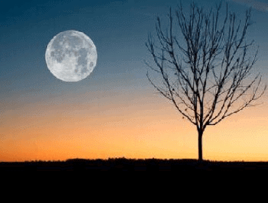 View of moon
- The Moon is the Earth's natural satellite with a diameter of about 3,480 km and a mass approximately 1/81 that of the Earth.
- The mean distance between the Earth and the Moon is about 385,000 km.
- The Moon takes about 27 days, 7 hours, 43 minutes and a number of seconds to complete one revolution around the Earth (the exact seconds value is illustrated with the image below).

- The Moon keeps essentially the same face toward the Earth because it rotates on its axis once in about the same time it takes to orbit Earth (synchronous rotation).
- At any time half the Moon's surface is illuminated by the Sun; phases of the Moon depend on the relative positions of the Sun, Earth and Moon.
Eclipses
- An eclipse is the total or partial obscuration of the light from one celestial body when it passes through the shadow of another body. Solar eclipses occur when the Moon comes between the Sun and the Earth; lunar eclipses occur when the Earth's shadow falls on the Moon.
Geoid
- The geoid is the theoretical figure of the Earth that represents mean sea level extended continuously through the continents; it is a surface of equal gravitational potential determined by the Earth's mass distribution and rotation.
- Astronomical observations, including those by French astronomer Jean Richer and others, showed that the Earth is not a perfect sphere but is slightly flattened at the poles.
- The true shape of the Earth is commonly approximated as an oblate ellipsoid or ellipsoid of revolution, flattened along the axis of rotation.
Great Circle and Small Circle
- A great circle is a circle on the Earth's surface whose plane passes through the Earth's centre; it divides the Earth into two equal halves. The Equator is an example of a great circle. The shortest route between two points on the globe lies along the great circle that passes through them.
- A small circle is formed when the plane cutting the Earth does not pass through its centre. Most parallels of latitude (except the Equator) are small circles.


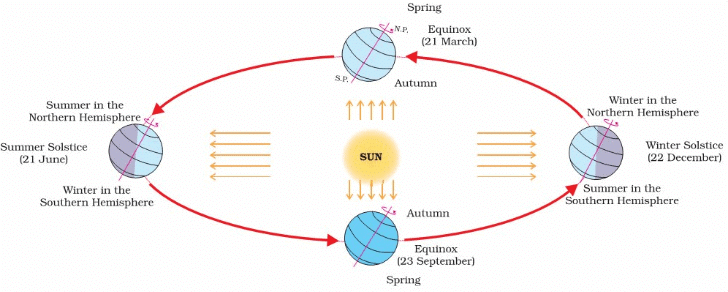
Solstice
- On or about 21 June, the Northern Hemisphere is tilted towards the Sun and the Sun's rays fall vertically on the Tropic of Cancer (23½° N). The Northern Hemisphere receives more direct solar radiation; days are longest and nights shortest in the northern regions. Areas north of the Arctic Circle experience continuous daylight (midnight sun) for some time.
- At the same time it is winter in the Southern Hemisphere where days are shorter and nights longer. This position of the Earth is referred to as the summer solstice for the Northern Hemisphere and the winter solstice for the Southern Hemisphere.
- On or about 22 December, the South Pole is tilted towards the Sun and the Sun's rays fall vertically on the Tropic of Capricorn (23½° S). The Southern Hemisphere then experiences summer (longer days), while the Northern Hemisphere experiences winter (shorter days). This is the summer solstice for the Southern Hemisphere.
Equinox
- On or about 21 March (vernal equinox) and 23 September (autumnal equinox), the Sun's rays fall directly on the Equator. At these times neither pole is tilted towards the Sun and the whole Earth experiences nearly equal day and night.
- On 23 September it is autumn in the Northern Hemisphere and spring in the Southern Hemisphere. On 21 March it is spring in the Northern Hemisphere and autumn in the Southern Hemisphere.
- In summary: Rotation of the Earth causes day and night; Revolution of the Earth around the Sun combined with the axial tilt causes seasonal changes.
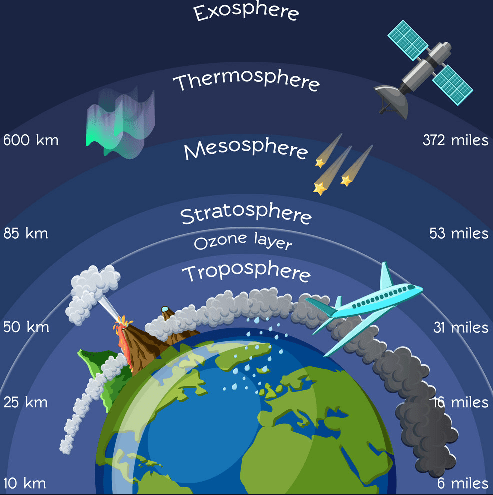
Atmosphere - Layers and Characteristics
Troposphere
- The troposphere is the lowest layer of the atmosphere, extending from the surface to about 8 km at the poles and up to about 16 km at the Equator.
- Temperature in the troposphere generally decreases with height (lapse rate). A commonly used average environmental lapse rate is about 1°C decrease per 165 metres (approximately).
- The troposphere contains most of the atmospheric water vapour and is the layer where weather phenomena occur.
Stratosphere
- The stratosphere lies above the troposphere. The boundary between them is called the tropopause; the upper boundary of the stratosphere is called the stratopause.
- Within the stratosphere temperature generally increases with height, from about -60°C near the tropopause to around 0°C near the stratopause.
- The stratosphere contains the ozone layer, especially in tropical and mid-latitudes, which absorbs harmful ultraviolet radiation and thus warms the layer.
- The stratosphere provides stable conditions favourable for high-altitude aircraft flight.
Mesosphere
- The mesosphere extends roughly from the stratopause at about 50 km to the mesopause at about 80-90 km.
- Temperature in the mesosphere decreases with altitude, reaching very low values (around -100°C) at the mesopause.
Thermosphere and Exosphere
- The thermosphere begins around the mesopause (about 85 km) and extends upward; in the input coverage it is stated up to about 400 km. Temperature in the thermosphere increases significantly with altitude due to absorption of high-energy solar radiation.
- The exosphere is the outermost region of the Earth's atmosphere and forms a transitional zone to interplanetary space; the exosphere is commonly placed above about 400 km altitude.
- The magnetosphere is the region dominated by the Earth's magnetic field; it extends tens of thousands of kilometres into space (about 60,000 km toward the Sun and further away on the night side) and protects the Earth from charged particles of the solar wind.
 Layers of atmosphere
Insolation
- Insolation (incoming solar radiation) is the radiant energy received at the Earth's surface from the Sun. The Sun emits a wide spectrum of energy from short X-rays through visible light to longer infrared waves.
- Only a very small fraction of the Sun's total radiation reaches the Earth's surface-yet it is essential for climate, weather, and life on Earth.
Concluding Summary
This chapter has established the basic geographic co-ordinate system of latitude and longitude, explained Earth's rotation and revolution and their consequences for time, day/night and seasons, described significant parallels and meridians (including the Prime Meridian and the International Date Line), and summarised the structure of the Solar System, the Moon and the principal layers of the atmosphere. The images and question placeholders inserted in appropriate sections provide visual and assessment anchors for classroom use.
FAQs on Earth - Basics, Latitudes and Longitudes
| 1. What are the differences between latitude and longitude? |  |
| 2. How does the Earth's rotation affect time zones? | |
| 3. What is the significance of the International Date Line? | |
| 4. What are solstices and equinoxes, and why are they important? | |
| 5. How does the Moon influence Earth, and what are its phases? | |


