Indian Climate - Impact of Monsoons, Droughts, and Flooding | Geography for UPSC CSE PDF Download
| Table of contents |
|
| Climate Regions of India |
|
| Climate and Natural Disasters in India |
|
| Flash Floods |
|
| Rainfall in India |
|
| Indian Weather and Jet Streams |
|
Climate Regions of India
India has several distinct climatic regions, each with its own unique characteristics. Here’s a detailed look at these regions:

Tropical Rainy Climate Region
- In this region, temperatures are consistently warm, staying above 18°C throughout the year.
- The hottest months are December, April, and May, with temperatures ranging from 18°C to 27°C.
- July and August are the coolest months, marked by heavy rainfall.
- The average annual rainfall exceeds 250 cm, which supports the growth of wet evergreen forests.
- Areas with this climate include the western coastal strip, the Western Ghats south of Bombay, Meghalaya, western Nagaland, and Tripura.
Tropical Savanna Region (Dry Climate)
- This region is characterized by a long dry period.
- Even in winter, temperatures remain above 18°C, with summer temperatures soaring up to 46°C.
- Summer rainfall averages about 100 cm, except in southeastern areas where rainfall is sufficient due to retreating monsoons.
- This climate region includes most of the southern peninsula, excluding the arid tract east of the Western Ghats, northeastern Gujarat, south Bihar, most parts of Madhya Pradesh, Odisha, parts of Andhra Pradesh, eastern Maharashtra, and eastern Tamil Nadu coast.
Tropical Steppes Region
- In this region, the average temperature is over 27°C, with the lowest temperatures around 23°C.
- April and May are the hottest months, with temperatures exceeding 30°C.
- The region receives less than 75 cm of rainfall, making it vulnerable to drought conditions.
- Rainfall occurs mainly during the southwest monsoons.
- This region includes rain shadow areas east of the Western Ghats, covering parts of Karnataka, interior Tamil Nadu, western Andhra Pradesh, and central Maharashtra.
Sub-Tropical Steppe Region
- Average temperatures in this region are over 27°C, with summer temperatures reaching as high as 48°C.
- Rainfall from the southwest monsoons averages between 50 and 75 cm.
- Rainfall is often insufficient, leading to widespread drought conditions.
- The region stretches from Punjab to Kutch and Saurashtra, including western Rajasthan and northern Gujarat.
Tropical Desert Region
- Summer temperatures in this region exceed 48°C, while winter temperatures can drop to 10°C.
- May and June are the hottest months.
- Average annual rainfall is only 12.5 cm and is highly unreliable.
- High evaporation rates during summer and cold winters limit crop production, except in areas with river irrigation.
- This region includes western Rajasthan and parts of Kutch, characterized by sandy plains.
Humid Sub-Tropical Region
- Summer temperatures in this region range from 46°C to 48°C.
- Average rainfall, primarily from summer monsoons, is about 62.5 cm, increasing to over 250 cm in eastern areas.
- Winters are generally dry.
- This region encompasses the foothills of the Himalayas, eastern Rajasthan, the plains of Uttar Pradesh, Bihar, northern Bengal, parts of Assam, and Arunachal Pradesh.
Mountain Region
The mountain region of India is characterized by:
- Altitude: The region consists of high-altitude areas, where the climate varies with elevation.
- Temperature: Generally cooler temperatures compared to other regions, with significant variations between day and night.
- Precipitation: Higher levels of precipitation, which can vary from region to region within the mountains.
- Vegetation: Diverse vegetation ranging from alpine meadows to dense forests, depending on the altitude.
- Human Activity: Limited agricultural activity due to harsh conditions, but some areas support livestock grazing and tourism.
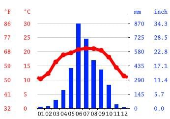 Shillong rainfall pattern
Climate and Natural Disasters in India
The average temperature in June ranges from 15°C to 17°C, while in winter, it can drop below 8°C. On the northern slopes of the Himalayas, rainfall is substantial, usually exceeding 200 cm. In contrast, the western slopes receive over 250 cm of rain. The entire Himalayan region, including both the trans-Himalayas and the main Himalayas, falls under this category.
About 12% of India’s area gets less than 61 cm of rainfall on average, and only 8% receives over 250 cm. Drought conditions arise due to the unpredictable nature of the Indian monsoons.
Drought Cycle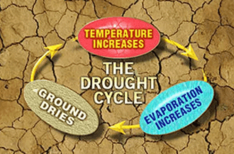 Drought Cycle
Areas Affected by Drought
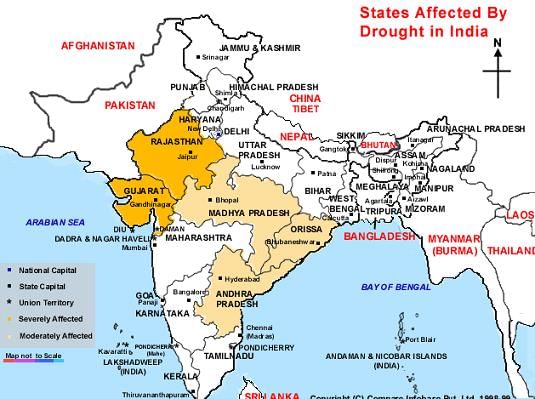 Areas affected by drought
Causes of Flooding
Nearly 60% of the flood damage in India comes from river floods, while 40% results from heavy rainfall and cyclones. Himalayan rivers are responsible for 60% of the total flood damage, with Central Indian rivers causing the least damage. Uttar Pradesh (U.P.) accounts for about 33% of the flood damage in the country, followed by Bihar at 27%, and Punjab and Haryana together at 15%.
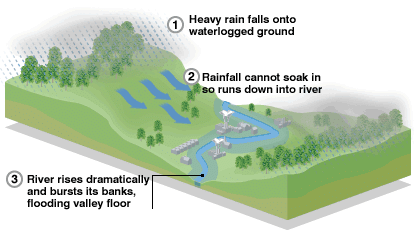 Cause of Flood
Flood Prone Areas
The flood-prone areas include:
- The basin of Himalayan rivers, which affects parts of Punjab, Haryana, Himachal Pradesh, Delhi, Rajasthan, U.P., Bihar, and West Bengal due to overflow, erosion, poor drainage, steep river gradients, and changes in river courses. Kosi and Damodar rivers cause significant devastation. The Brahmaputra basin is prone to earthquakes and landslides, obstructing water flow.
- The North Western river basin, including Jammu and Kashmir, parts of Haryana, western U.P., Punjab, and Himachal Pradesh, is affected by the Indus tributaries (Jhelum, Sutlej, Beas, Ravi, and Chenab). In the Kashmir Valley, the Jhelum struggles to handle flood discharge, while Punjab and Haryana face issues mainly due to inadequate drainage.
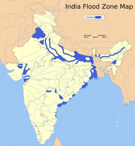 Flood-prone areas of India
Flood Control Policy and Programmes
The national flood control policy consists of three phases:
- Immediate phase: Lasts two years and includes collecting basic hydrological data, building embankments, urgent repairs, improving river channels, and raising villages above flood levels.
- Short-term phase: Covers four to five years, focusing on enhancing surface drainage, establishing a proper flood warning system, relocating or elevating villages, constructing channel diversions, more embankments, and building raised platforms for flood emergencies.
- Long-term phase: Involves plans for building dams or storage reservoirs for flood protection and soil conservation in river catchment areas, creating detention basins, and digging large channel diversions.
Since the launch of the National Flood Control Programme in 1954, protective measures have been implemented starting from the second plan, with an emphasis on drainage and anti-waterlogging measures. Flood forecasting and warning centres have been established in some of the most flood-prone areas. Flood Control Boards and River Commissions have been set up in all states to coordinate and implement these measures. A Central Flood Control Board has also been established at the national level to oversee the activities of State Boards and River Commissions.
Multipurpose reservoirs with dedicated flood control storage have been constructed on several rivers, including:
- Mahanadi (at Hirakud)
- Damodar (at Konar, Maithon, Panchet, and Tilaiya)
- Sutlej (at Bhakra)
- Beas (at Pong)
- Tapti (at Ukai)
These reservoirs have provided significant protection to lower river areas. Some multipurpose reservoirs, like Bhakra Nangal on the Sutlej and Nagarjun Sagar, do not have specific flood moderation storage but still help manage floods downstream. Additionally, various flood protection works, including building embankments, drainage channels, town protection measures, and raising villages, have been carried out. Flood forecasting systems have also been established in various locations.
Flash Floods
Flash floods are sudden and intense floods that occur in areas that are usually dry, particularly in valleys. These local events are typically triggered by heavy rainfall during the monsoon season. During such floods, water levels can rise dramatically in a very short period of time, causing fast and powerful water flow.
Flash floods can activate hidden or inactive drainage systems, turning them into active temporary streams. This can lead to flooding in large areas that are illegally cultivated in these buried drainage beds, severely affecting the environment in low-lying regions and causing a decrease in productivity. Moreover, the flooding can result in the collapse of homes, roads, and bridges.
Flood Prevention Measures
To mitigate the risk of flash floods, it is crucial to establish proper plant cover in these areas through an appropriate silvopasture system. The following measures are recommended:
- Sow grass on field bunds, often supported by trenches, and plant trees within these trenches.
- Regulate farming activities near temporary streams.
- Reinforce the banks of these streams with vegetation.
- Avoid cultivating the beds of dead or buried drainage systems.
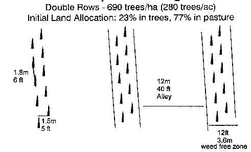 Silvopasture design
Rainfall in India
- The majority of rainfall in India is attributed to the southwest summer monsoons, which usually occur from mid-June to mid-September.
- This rainfall is seasonal and can be unpredictable, with variations in timing and intensity.
- Occasionally, monsoons may arrive early, leading to floods, while at other times, they may be delayed, resulting in drought conditions.
- The early or late withdrawal of monsoons can also trigger severe drought situations.
- Rainfall distribution across the country is uneven:
- Around 10% of India receives more than 200 cms of rain.
- Approximately 25% of the country receives less than 75 cms of rain.
- Indian rainfall is often heavy, encapsulated in the saying, “It pours, it never rains in India.”
- The presence of mountains influences rainfall patterns; high mountains force monsoons upwards, resulting in precipitation.
- Summer rain is often characterized by dry spells or breaks.
- Most regions experience variable rainfall, fluctuating by as much as 30 cms either way.
- This variability can lead to famines in areas with insufficient rainfall.
Importance of Monsoons for Agriculture
- Agriculture is the backbone of India’s economy, heavily reliant on the southwest summer monsoons.
- The saying, “The Indian budget is a gamble on monsoons,” reflects the dependence on these rains.
- Summer crops, known as Kharif crops, are dependent on the monsoons.
- A failure in the summer monsoons can lead to famines and food shortages; the phrase “If monsoons fail, there is a lockout in the agriculture industry” underscores this risk.
- Food grains such as rice, jowar, and maize, grown as Kharif crops, require consistent rainfall.
- Abundant rainfall can result in bumper harvests.
- The type of crops grown is influenced by the amount of rainfall:
- Areas with over 200 cms of rain cultivate rice, sugarcane, tea, and jute.
- Drier regions produce millets, pulses, and oilseeds.
- Consistent rainfall distribution enables multiple cropping seasons.
The coastal areas of India experience stable temperatures year-round, with minimal variation in summer and winter. This stability is due to the sea's moderating effect, as it heats and cools slowly, retaining warmth during winter and coolness during summer. The land and sea breezes contribute to maintaining these temperatures, resulting in a very low annual temperature range. There is virtually no winter season; temperatures remain consistently high.
Rainfall distribution in India is uneven, with significant regional differences. This distribution shows two primary trends:
- Rainfall decreases from the coastal regions towards the west and northwest.
- Rainfall diminishes as one moves inland.
Key factors affecting this rainfall distribution include:
- The presence of high mountains.
- The distance from the sea.
Coastal regions receive substantial rainfall, with areas like the Western Ghats, the Garo-Khasi hills, and the Sub-Himalayan region receiving over 200 cms of rain. In contrast, Rajasthan is arid due to the lack of high mountains to capture the southwest monsoons. Its western part is desert-like, receiving less than 20 cms of annual rainfall. This aridity is due to several factors:
- Rajasthan is affected by southwest summer monsoons, but the Aravalli mountain range runs parallel to these winds, preventing moisture capture.
- The region's distance from the Bay of Bengal causes the monsoon winds to lose moisture before reaching Rajasthan.
- Rajasthan is also far from the Himalayan region, which is vital for receiving monsoon rains in the Sub-Himalayan areas.
The coefficient of variation of annual rainfall is low on the west coast of India but high in regions like Kutch and Gujarat. A notable aspect of monsoon rainfall in India is its year-to-year variability, with differing amounts of rainfall recorded at the same location each year. When actual rainfall deviates from the mean annual rainfall, it is termed rainfall variability.
Indian Weather and Jet Streams
- The coefficient of variation on the west coast of India is as low as 15 percent. This means that the monsoons here are very consistent year after year because these areas are close to the sea.
- In Kutch and Gujarat, the coefficient of variation can be as high as 40 percent. This indicates that the monsoons in these semi-desert regions can be weak and unpredictable.
- There are areas where the coefficient of variation is between 50% and 80%. In these places, there are no tall mountains to block the monsoon, leading to more variability.
Factors Influencing Indian Weather
Indian weather is affected by several important factors, including:
- Surface distribution of pressure and winds.
- Upper air circulation.
- Flow of different air masses.
- Western disturbances.
- Jet stream.
These factors interact to shape Indian weather. Jet streams are fast winds high up in the atmosphere, in the upper troposphere. One important jet stream blows over Central Asia and the Himalayas. This jet stream has a big impact on Indian weather and monsoons in several ways:
- In winter, high pressure in Central Asia pushes northwestern continental air masses into North India.
- The jet stream helps carry these winds into India, along with western disturbances. These disturbances come from the Mediterranean Sea and bring light winter rain to Northern India.
- The Himalayas divide the westerly winds into two branches: the Northern and Southern branches. The southern branch flows around latitude 25°N.
- In summer, the intertropical convergence zone (I.T.C.Z.) replaces the jet stream. This low-pressure area attracts the southwest monsoons, which are an extension of the southeast trade winds.
- The easterly jet stream flows over Northern India, helping guide tropical depressions across the country. These cyclones contribute to monsoonal rainfall and explain the dry spells caused by changing tropical depression patterns
|
175 videos|477 docs|193 tests
|
FAQs on Indian Climate - Impact of Monsoons, Droughts, and Flooding - Geography for UPSC CSE
| 1. What is the climate like in India? |  |
| 2. What are the main factors that influence India's climate? | |
| 3. How does the monsoon season affect India's climate? | |
| 4. Which regions in India have a tropical monsoon climate? | |
| 5. How does the Himalayan mountain range impact India's climate? | |

|
1.2K Views |

|
4.86/5 Rating |

|
Dec 23, 2024 Last updated |

|
Explore Courses for UPSC exam
|
|
Droughts
,past year papers
,Exam
,MCQs
,Droughts
,Indian Climate - Impact of Monsoons
,shortcuts and tricks
,Previous Year Questions with Solutions
,ppt
,Objective type Questions
,practice quizzes
,mock tests for examination
,and Flooding | Geography for UPSC CSE
,and Flooding | Geography for UPSC CSE
,Semester Notes
,Summary
,Extra Questions
,Indian Climate - Impact of Monsoons
,video lectures
,Droughts
,Viva Questions
,Sample Paper
,study material
,Important questions
,Free
,Indian Climate - Impact of Monsoons
,and Flooding | Geography for UPSC CSE
;


Indian Climate - Impact of Monsoons, Droughts, and Flooding Free PDF Download
Importance of Indian Climate - Impact of Monsoons, Droughts, and Flooding
Indian Climate - Impact of Monsoons, Droughts, and Flooding Notes
Indian Climate - Impact of Monsoons, Droughts, and Flooding UPSC Questions
Study Indian Climate - Impact of Monsoons, Droughts, and Flooding on the App
|
© EduRev
|
Education Revolution
|


|


