Water Resources and Irrigation - 1 | Geography for UPSC CSE PDF Download

Water is an important resource required for the irrigation, navigation, generation of hydro-electricity and for industrial and domestic consumption. Irrigation is by far the major consumer of water resources.
Most of India's water resources are located in the zones with an annual rainfall of 125 cm and above. But need for irrigation is particularly the greatest in the zones of medium to low rainfall. Underground water is brackish in large parts of west Rajasthan and many of our rivers are facing the danger of pollution by discharge of urban and industrial wastes. On the other hand, the scarcity of drinking water is being felt more acutely in our major cities because of the increasing size of their population. A large number of our rural areas are still without safe and reliable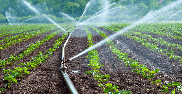 Water irrigation supply of potable water through out the year. In Madras the scarcity of water for meeting the domestic and industrial needs was so acute a few years back in summer months that there was talk about desalination of sea water in spite of the high cost of this process. Therefore there is a need to judiciously plan the use of available water in order to meet the demands from all quarters.
The Department of Irrigation, now known as Ministry of Water Resources (from 1985 onwards) is the nodal agency for coordinating measures aimed at development, conservation and management of water as the national resource. National Water Policy, formulated in 1987, recommends the need for integrated and multidisciplinary approach of planning, formation and implementation of water resource related projects. Highest priority has been given to drinking water followed by emphasis on irrigation, hydro-power, navigation, industrial and other uses, Emphasis is also laid on flood management.
Water Potential
If water is allowed to stand to a depth of one metre over a level piece of land, one hectare in area (i.e. 10,000 sqm), the total volume of water so contained is termed one hectare metre (i.e. 10,000 m3). Now taking into account the normal flow of the rivers of India, it has been estimated that the water resources are about 187 million hectare metres. Of this, nearly 69 million hectare metres of the surface water and 43.2 million hectareas metres of ground water is usable. Against this, the utilisation which was about 17 million hectare metres in 1950-51 has now increased to 90 million hectare metres and is likely to go up to 105-110 million hectare metres by 2010-2020.
By present estimate, the ultimate irrigation potential through conventional sources is likely to be about 150 million hectares (it was estimated at 113 million hectares till 1992) by 2015 AD due to more ground water availability from 40 million hectare metres to 64 million hectare metres. Further the inter basin transfers based on proven technology have a potential of additional irrigation upto 35 million hectare.
Need for Irrigation
Timely and adequate supply of water is essential for successful cultivation of crops. Water for irrigating crops is available from a number of sources like rain, rivers, springs and underground. Rain-water is the natural and ideal source for irrigation. But unfortunately rainfall in our country is seasonal, uncertain and highly unevenly distributed. Sometimes there is a failure of rainfall which may lead to failure or damage of crops. Hence sources of water other than rain water is tapped, wherever possible, for cultivation of crops. This artificial application of water to crops is known as irrigation.
The importance of irrigation in Indian agriculture can be estimated from the following given reasons.
(i) Uneven and uncertain rainfall: The rainfall in India is very uncertain and its amount varies widely in India. It is less than 75 cm over 30% of the total land area, between 75cm and 85cm over 60% of land area, and more than 185cm over the remaining 10% land area. Further, the amount of rainfall over any particular area is unevenly distributed over the year. Nearly 75% of the total rainfall comes in 3-4 months, the rest of the year getting only 25%.
The heavy rainfall that takes place in the wet months is not very useful since most of it flows into the rivers and only a small part seeps through the earth. Irrigation, therefore, is indispensable for raising a second crop during the dry weather all over the country and it is desirable even during the rainy season to counter the effect of short dry spells which are not uncommon. 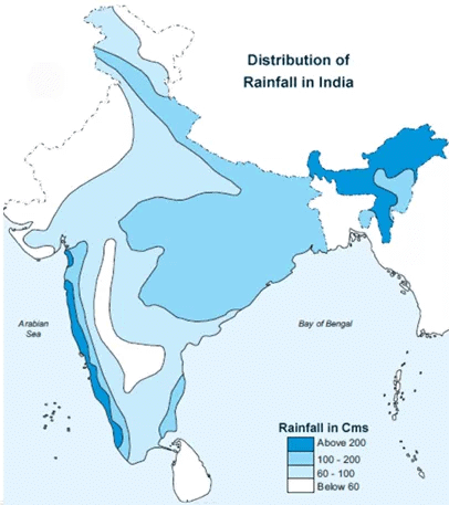 Distribution of rainfall(ii) Fluctuating water flow in rivers: The Himalayan rivers are both snowfed and rainfed whereas the peninsular rivers are entirely rainfed. The Himalayan rivers have continuous flow throughout the year, but the amount of low in them varies widely in different seasons. The rivers of peninsular India flow only during the rainy season and dry up in the hot season. Thus, river water is not available for irrigation throughout the year.
(iii) Cultivable land has reached its limit: Nearly 50% of the total land area is under the plough in India. Only 5% more land is available for cultivation. Food production for our teeming millions can, therefore, be increased by irrigation.
(iv) Different water requirements of different crops: Because of the year round growing season and variety of soils and climatic conditions, it is possible to grow a wide variety of crops in India. Different crops have different requirements of water during their growing period which can be met only through irrigational facilities. Successful cultivation of rabi crops needs irrigation because only a nominal rainfall during the rabi crop season takes place. Sandy soils require frequent water supply than the alluvial or black soils.
Country's food security depends on the performance, delivery and expansion of the irrigation sector.
Since 64 per cent of the working population is engaged in agricultural vocations, irrigation not only enhances the employment potential in the rural areas by turning seasonal employment into a more stable year round employment, but also reduces migration of rural population to urban areas. Irrigation also provides foodgrains security against the vagaries of monsoon and increases cropping intensity on the same area of land resulting in more foodgrain production per hectare of land.
Thus, the importance of irrigation in ensuring food security, employment generation, poverty alleviation, reduction in social tension in rural areas and in reducing migration of rural poor to the urban areas is very obvious and vital.
Irrigation support in India is provided through major and medium irrigation projects, command areas development, use of underground water and surface water.
System and Methods Irrigation
The design, the equipment and the technique used for replenishing the soil-water deficit by applying irrigation water is known as irrigation system. The system of irrigation used in different parts of the country are governed by local meteorological, geological and other physical conditions. Therefore there cannot be any uniformity in the system of irrigation in different parts of the country.
The main methods of irrigation in India are discussed below:
(a) Surface Irrigation 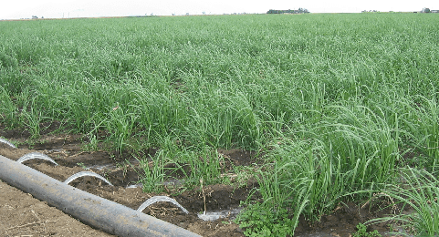 Surface irrigation In this system water is directly applied to the surface of the soil which spreads by gravity flow incidental to the slope of the field. This system uses several methods such as flooding from a ditch, check basin, ring and basin, border strip and furrow. In the surface irrigation system fields are laid out every time before the crops are sown, since these layouts are disturbed during preparatory tillage. The fields are levelled well for increasing water-application efficiency.
The check-basin method of irrigation, widely practised in India, is ideal for all irrigable soils and variety of crops. In this fields are laid in the form of checks, rectangular or square, in varying sizes (10 to 100 m2 or even more) and with levelled basins. On steeper slopes this method is used after proper terracing. The drawback of this method is that it has too many ridges which not only occupy land but also hinder interculture and harvesting with mechanical means.
In the ring and basin method water is applied to the soil only around the tree and not the entire field, thus saving water. In border-strip irrigation method, the field is divided into long narrow strips with small parallel ridges on the sides. It is well suited to all irrigable soils and to closely spaced row crops and even to pasture crops. Larger flows are required for irrigating borderstrips than those in case of other layouts.
In furrow irrigation water is applied to the field in furrow between two ridges and the top of ridge is not directly wetted.
(b) Subsoil Irrigation
In this system water is applied to a series of field ditches deep down to impervious layer which then moves laterally and vertically through capillary action and saturates the root zone. This artificial water table created by pounding of irrigation water in the impervious layer ensures a continuous supply of moisture in the crop root zone.
(c) Sprinkler Irrigation 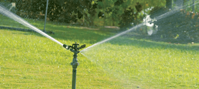 Sprinkler irrigation system Sprinkler irrigation is a system in which water is applied to the surface of crop or soil in a thin spray from above. The advantage of this method is that water can be applied efficiently at controlled rate and with a uniform distribution. This system of irrigation can be used in saline soils because it helps in leaching of salt more effectively, and securing quicker and better growth of plants. Sprinkler system helps in cooling the crops during high temperatures and in frost control during freezing temperatures. This method is also used for applying pesticides, weedicides and fertilisers in solution form. The equipment used in a typical sprinkler system consists of a pumping unit, pipes and the sprinkler head or nozzle.
(d) Drip Irrigation
Drip irrigation, also called micro or trickle irrigation, is a system of irrigation in which water is applied slowly, drop by drop, as the name suggests, to the root zone of a crop and not the whole field. This method, initiated in Israel, uses water very economically, since losses due to deep percolation and surface evaporation are reduced to minimum and prevents weeds and unwanted plants to grow in field. This method is ideal for arid regions and is being used for irrigating orchard crops even on saline soils. This system can also be used for applying fertilizers in solution. The equipment used consists of a pumping unit and pipe-lines with drip type nozzles.
India has begun to design and adopt drip irrigation, though initial high cost of equipment and its maintenance are major limitations of this system. It is however cheaper than sprinkler system especially for orchards and other widely spaced crops.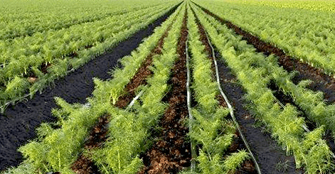 Drip irrigation system(e) Well and Tube Well Irrigation
Wells and tube wells derive water from underground sources and account for 40% of the total irrigated area in our country. Well and tube well irrigation, therefore, is possible even in low rainfall areas provided a sufficient quantity of ground water is available. Well irrigation is used mainly in the alluvial plains where owing to the soft nature of the soil, wells are easy to dig. The Punjab-Haryana Plains (excluding the dry area close to Rajasthan), plains of Uttar Pradesh, Bihar and Gujarat, a few places in the Narmada valley, the Tapti valley and Tamilnadu are suitable for well irrigation.
However, large tracts in the peninsula hold little sub-surface water and, therefore, are unsuitable for well irrigation. In some parts of Rajasthan, Haryana, Punjab, Uttar Pradesh and Gujarat the groundwater is saline and, therefore, unsuitable for irrigation. In south Haryana and western Rajasthan, where the depth of the water-table exceeds 50 m, the cost of lifting it makes the method prohibitively expensive.
Some or the other type of lift is always required for using the well-water for irrigation. Whereas old methods like mot and reht are still practised widely in many areas, power-driven pumps have become exceedingly popular in most parts. A power driven pump can irrigate up to 2 hectares per day as against only 0.2 hectare by a reht. The power-driven pump can also lift water from a much greater depth.  Tube-well irrigation system Well irrigation accounts for about 41 per cent of the net irrigated area in the country. Over three-fourths of the net irrigated area is under well irrigation in Gujarat; about 50-55 per cent in Maharashtra, Rajashtan, Uttar Pradesh and Punjab; 30-40 per cent in Haryana, Madhya Pradesh, and Tamilnadu and below 30 percent in Bihar, Karnataka, Orissa and Andhra Pradesh.
(f) Canal Irrigation
Canal irrigation is the principal method of irrigation in India because of its cheapness, and the ease and certainty with which water is supplied. India has one of the world's largest canal systems stretching over more than one lakh km and accounting for 40 percent of the net irrigated area. The essential requirements for canal irrigation are an adequate source of water supply (perennial rivers), a low level relief with deep fertile and soft soil and an extensive command area.
Thus it is natural that canal irrigation is limited to the plains of northern India, or coastal lowlands, southern delta and broad valley plains in the Indian plateau. The digging of canals in rocky uneven areas is very expensive and of limited use. Hence large areas of Indian plateau are irrigated by means other than canals. The canals in India are of two types:
(i) Inundation canals, which are taken off from rivers without any regulating system like barrage or dam at their heads. Such canals are built to use the excess water of rivers at the time of floods and therefore provide irrigation mostly during the rainy season and hence of limited use.
(ii) Perennial canals, which are taken off from perennial rivers or reservoirs with some form of barrage to regulate the flow of water. It runs all the year round irrespective of the volume of water in the river. Most of the canals in India are of this type. Almost all the canals in the Great Plains take off from barrages on perennial rivers, the water being merely diverted into them, whereas construction of large dams and reservoirs is necessary for taking off canals in the Peninsula. Most of the canals in the Peninsula are found in the lower valleys and deltas of large rivers.
Almost half of India's net canal irrigated area is in Uttar Pradesh, Punjab, Haryana, and Andhra Pradesh, The remaining half of the area lies in West Bengal, Tamilnadu, Bihar, Rajasthan, Madhya Pradesh, Karnataka, Assam, Maharastra, Orissa, Jammu and Kashmir and Gujarat in that order of importance. 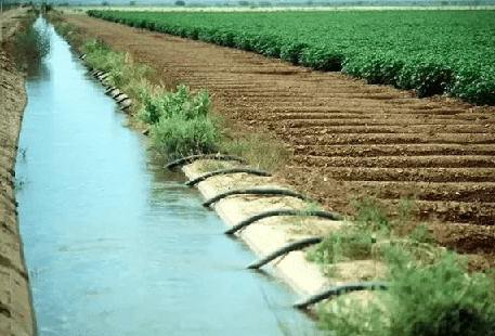 Canal irrigation(g) Drawbacks of Canal Irrigation: In an unlined can water soaks into the ground thus raising the level of the sub-soil water in the canal irrigated areas. Sometimes the water-table may reach the surface rendering the once cultivable land into completely waterlogged. Further, swamps may be formed if the soil is completely saturated with water. In places where the water-table is still a few feet below the ground, may, due to capillary action, bring alkaline salts to the surface, Thus making the soil highly alkaline which is unproductive.
This development of alkaline soils, waterlogging or swamps which first occurs in low lying areas and in the immediate vicintiy of canals, slowly starts affecting the neighboring areas, covering them first into highly alkaline, then into waterlogged and at last into unproductive swampy areas. In the process, it is not only the fertile soil is rendered useless but also roads and buildings are damaged because of soft wet soils, well water too is affected making it unfit for drinking.
As the soil is saturated with water due to waterlogging, even a small excess of normal rainfall may lead to large areas covered with rain water, which in absence of proper drainage may remain standing for a long time and may damage the standing crops, houses and even stored foodgrains and fodder. However the problem of waterlogging is not so acute in areas where the main canals are lined with bricks.
(h) Tank Irrigation
In the uneven and relatively rocky plateau of peninsular India, where rainfall and rivers are highly seasonal, tank irrigation is the most feasible and widely practised method of irrigation. This method accounts for 12% of the total irrigated area of our country. In this method a small bund of earth or stones is built across seasonal streams to hold water which is led through narrow channels to the fields.
Tank irrigation is most suitable in peninsular India including Maharashtra and Gujarat because of the following mains reasons:
(i) The land is rocky and the soil is not porous. The rain water does not easily sink into the ground. Therefore, wells are not of much benefit.
(ii) The digging of canals is difficult and expensive on the rocky surface of the peninsular plateau. Moreover, South Indian rivers are seasonal. Perennial canals are successful only if the rivers have perennial flow of water.
(iii) The uneven rocky terrain of South India allows easy construction of tanks and reservoirs. The hard rocks do not allow the water of tanks to seep through.
(iv) The scattered population of the tract also favors tank irrigation.  Rhino water tank irrigation
The main drawbacks of tank irrigation are:
(i) All tanks get silted up soon and should be desilted regularly for continuous use.
(ii) Tanks occupy large fertile land particularly as the depth of most of the tanks is shallow and water spreads over a large area.
(iii) Rate of evaporation of water is relatively high due to large expanse of shallow water of tanks.
(iv) Tanks do not ensure perennial supply of water. Considering these facts, tank irrigation is less economical than well and tube-well irrigation. Andhra Pradesh leads in tank irrigation, followed by Tamilnadu, Karnataka, Orissa and Maharashtra.
Irrigation Distribution
The area under irrigation is more concentrated in the Great Plains and the East Coastal Lowlands than the uplands in the Peninsular or extra-Peninsular regions due to a greater concentration of the net sown area and availability of more surface and sub-surface water in these regions. Over a fifth of the country's net irrigated area lies in Uttar Pradesh. Next in importance come Punjab, Haryana, Andhra Pradesh, Tamilnadu, Bihar and Rajasthan.
Irrigation is largely confined to Northern Plains because:
(i) the alluvial soil of the plain is highly fertile and gives a good return on the investment made in constructing canals;
(ii) the land in Northern Plains being soft and flat, canals and wells cab be easily constructed;
(iii) the level of the ground water in the Northern Plains is also quite high, making well irrigation economical:
(iv) the rivers of the Northern Plains are perennial and can feed the canals all round the year.
Irrigation Projects
Irrigation projects are classified as follows:
(i) Major irrigation project: Culturable Command Area (CCA) is more than 10,000 hectares.
(ii) Medium irrigation project: CCA more than 2000 hectares but less than 10,000 hectares.
(iii) Minor irrigation project: CCA less than 2000 hectares.
Major and medium irrigation works are meant for tapping surface waters, eg. river. Minor irrigation works are meant for tapping mainly ground water, eg. tubewell, boring wells, tanks etc.
Major Vs. Minor Irrigation Projects
Major irrigation project, besides acting as multipurpose projects which serve various purposes like flood control, navigation, hydro-power generation etc. also have large irrigation capacity and can serve large tracts of land. However these benefits of major irrigation projects have been exaggerated.
(i) The Planning Commission has admitted that major and medium works have yielded disappointingly low returns in terms of yield as well as finance.
(ii) Hydropower, besides being a renewable and nonpolluting source of energy, is regarded cheaper than thermal and nuclear power. In practice, however, there are persistent delays in commissioning hydro-projects since the gestation period is 5 to 12 years for hydro-projects, while only 5 years for thermal units and the cost of generating thermal power is Rs. 4,000 per kw while it is as high as Rs. 7,000 per kw in the case of hydropower.
(iii) The flood control measures of major irrigation projects have failed miserably over the years, the area affected by floods and the damage to crops, cattle and to human beings has increased sharply. A serious problem is the heavy siltation of the reservoirs of major dams; the rate of siltation is higher than originally estimated. Heavy siltation reduces the storage capacity and life span of many reservoirs which, as a result, are incapable of absorbing heavy floods.
(iv) Major irrigation works involve a huge investment and take a long period for completion, 15 to 20 years or more. Moreover the large bureaucracy associated with these projects is generally corrupt and inefficient and thus the cost over-runs are much greater
(v) There is heavy loss of water due to seepage- sometimes. This loss is as high as 50 per cent of water released. These losses occur because most of the distributaries are unlined and thus waterlogging is a serious problem.
(vi) Big dams and huge multi-purpose river valley projects have serious adverse environmental effects, particularly the degradation of the soil in the command areas of irrigation projects due to waterlogging and soil salinity. Quite a large area of precious agricultural land is wasted in developing distribution system.
Minor irrigation projects, on the other hand, require small investment and has a much shorter gestation period, it is mostly done in the private sector through the installation of wells, tubewells, pump-sets etc. There is, therefore, no wastage of land in distributaries. Problems of water logging are absent.
Farmers tend to economize the use of water since the system is directly under their control. Hence the key to better management, lies not in big dams at exorbitant financial and ecological costs, but in minor irrigation which ensures maximum use of ground water and better control over irrigation sources. 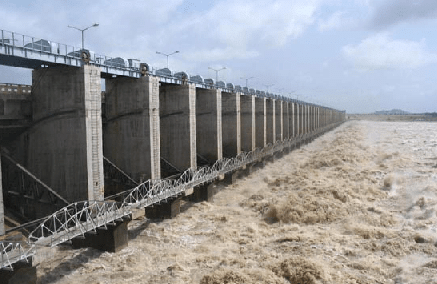 Major and medium irrigation projects
Command Area Development Programme
Command area is the total area where particular irrigation project is expected to cover in terms of irrigating the land as well as providing water for domestic purpose.
The main drawback of our irrigation system is the under utilisation of the created irrigation potential particularly in major and minor irrigation projects i.e. water is not put into optimum use. Therefore a Command Area Development Programme (CADP) was initiated at the beginning of Fifth Plan (1974-75) as a centrally sponsored scheme.
It is an integrated area development programme which aims at ensuring a faster and better utilization of the irrigation potential in the command areas of major and medium irrigation projects of the country (i.e. bridging the gap between created irrigation potential and its utilization), and increase in crop productivity under the command areas.
The programme broadly covers:
(i) On farm development which includes surveying and planning water course, land levelling, adoption of warabandi system of water distribution in project command areas, shaping and reclamation of degraded land.
(ii) Afforestation and pasture development which includes canal side and road side plantation, block plantation near new settlements, sand dune stabilisation and pasture development on cultivable wasteland.
(iii) providing communication and civic amenities which include setting up wireless network in order to ensure equitable and ensured supply of irrigation even in the tailend holdings, construction of roads, connecting the settlement with market, construction of new market and supplying drinking water.
(iv) Availability of modern agricultural inputs including ensuring supply of HYV seeds, chemical fertilizers, insecticides and pesticides and providing agricultural extension and training facilities to the farmers.
At inception in 1974-75, 60 irrigation projects were covered under the programme with a cultivable command area of 15 million hectare. In 1998-99 the programme covers 217 projects with a cultivable command area of 21.95 million hectare spread over 23 states and two union territories. The programme is being executed through 54 command area development authorities.
To achieve the physical target and ultimately the objectives of Command Area Development Programme the importance of farmer's participation in water management and effecting implementation of CADP had been emphasised.
|
175 videos|624 docs|192 tests
|
FAQs on Water Resources and Irrigation - 1 - Geography for UPSC CSE
| 1. What are the different sources of water for irrigation? |  |
| 2. How is water quality important for irrigation purposes? | |
| 3. What are some common irrigation methods used in agriculture? | |
| 4. How can farmers conserve water in irrigation practices? | |
| 5. How does climate change impact water resources and irrigation? | |


Water Resources and Irrigation - 1 | Geography for UPSC CSE
,Sample Paper
,past year papers
,practice quizzes
,Exam
,Extra Questions
,mock tests for examination
,Viva Questions
,shortcuts and tricks
,Important questions
,ppt
,study material
,Free
,Semester Notes
,Objective type Questions
,MCQs
,Water Resources and Irrigation - 1 | Geography for UPSC CSE
,Summary
,video lectures
,Water Resources and Irrigation - 1 | Geography for UPSC CSE
,Previous Year Questions with Solutions
;


Water Resources and Irrigation - 1 Free PDF Download
Importance of Water Resources and Irrigation - 1
Water Resources and Irrigation - 1 Notes
Water Resources and Irrigation - 1 UPSC Questions
Study Water Resources and Irrigation - 1 on the App
|
© EduRev
|
Education Revolution
|


|


within 7 days!