Introduction - Plane Table Surveying, Surveying and Levelling | Surveying and Levelling Notes- Agricultural Engg - Agricultural Engineering PDF Download
Plane Table Surveying
Plane table surveying is a graphical method of surveying in which the field works and the plotting is done simultaneously. It is particularly adopting in small areas mapping. Plane table surveying is used for locating the field computation of area of field.
Merits
- It is most suitable for preparing small scale map or surveying small area.
- It is most rapid method.
- Field book is not necessary.
- No great skill is required for satisfactory map.
- It is particularly suitable for magnetic area where prismatic compass is not reliable.
- Contour and irregular object may be represented accurately.
- It is less costly.
Demerits
- Plane Table Essentially a tropical instruments.
- It is not suitable to work in wet climate.
- There are several accessories to be carried out and therefore they are likely to be lost.
- It is not suitable for accurate work.
Plane Table essentially consists of a Drawing board mounted on tripod stand and Alidade.
1. Drawing board mounted on tripod: A sheet of drawing paper, called plane table sheet is fastened to the board. Board is made up of well seasoned wood such as teak of size 40x30 to 75x60cm. it had plane and smooth top. It is mounted on a tripod in manner that it can be leveled. Leveling up of the table is done by shifting the legs of tripod. Some tripod provided with leveling screw or by ball and socket head for accurate leveling.
2. Alidade: Alidade consists of two vertical sight vane fitted at end the end of straightedge. The straight edge ruler usually made of brass or teak wood graduated beloved edge. One of the sight veins is provided with narrow slit and the other with a central vertical wire or hair. Beveled working edge alidade is called fiducial edge.
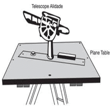
Fig. 6.1 Plane table with Alidade
Accessories used in Plane Table surveying are
- Trough compass
- U – frame or plumbing fork
- Water proof cover.
- Spirit level or level tube
- Drawing sheet
- Pencil or eraser
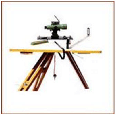
Fig. 6.2 Accessories in Plane Table surveying
- Trough compass: The compass is used to mark the direction of the meridian on the paper.
- U- frame or Plumbing fork: U frame with a plumb bob used for centering the table.
- Water Proof Cover: Water Proof cover protects the sheet from rain.
- Spirit level or level tube: A level tube is used to level the plane table.
- Drawing sheet: The drawing sheet is fixed on the top of the drawing board.
- Pencil and eraser: A pencil is used for constructing lines and eraser is used for erasing lines after completion of the plan.
FAQs on Introduction - Plane Table Surveying, Surveying and Levelling - Surveying and Levelling Notes- Agricultural Engg - Agricultural Engineering
| 1. What is plane table surveying? |  |
| 2. What are the advantages of plane table surveying? | |
| 3. What is surveying and leveling in agricultural engineering? | |
| 4. How is plane table surveying used in agricultural engineering? | |
| 5. What are the challenges in plane table surveying for agricultural engineering? | |

|
4.90/5 Rating |

|
Dec 23, 2024 Last updated |

|
Explore Courses for Agricultural Engineering exam
|
|
Surveying and Levelling | Surveying and Levelling Notes- Agricultural Engg - Agricultural Engineering
,Summary
,video lectures
,Previous Year Questions with Solutions
,MCQs
,Introduction - Plane Table Surveying
,Extra Questions
,past year papers
,Surveying and Levelling | Surveying and Levelling Notes- Agricultural Engg - Agricultural Engineering
,study material
,Free
,practice quizzes
,Exam
,Semester Notes
,mock tests for examination
,Objective type Questions
,shortcuts and tricks
,ppt
,Surveying and Levelling | Surveying and Levelling Notes- Agricultural Engg - Agricultural Engineering
,Sample Paper
,Important questions
,Introduction - Plane Table Surveying
,Viva Questions
,Introduction - Plane Table Surveying
;


Introduction - Plane Table Surveying, Surveying and Levelling Free PDF Download
Importance of Introduction - Plane Table Surveying, Surveying and Levelling
Introduction - Plane Table Surveying, Surveying and Levelling Notes
Introduction - Plane Table Surveying, Surveying and Levelling Agricultural Engineering Questions
Study Introduction - Plane Table Surveying, Surveying and Levelling on the App
|
© EduRev
|
Education Revolution
|


|


