Class 6 Geography Chapter 2 Question Answers - Globe Latitudes and Longitudes

Q1: Greenwich line passes through ______.
Ans. England.
The Greenwich line passes through England, which is its reference point for measuring longitude.
Q2: Why does the midday sun never shine overhead on any latitude beyond the Tropic of Cancer and the Tropic of Capricorn?
Ans. The mid-day sun never shines overhead on any latitude beyond the Tropic of Cancer and the Tropic of Capricorn due to the earth's tilt. Due to this tilt, the sun's rays fall on the earth's surface at different angles at different latitudes.
Q3: If it is 12 P.M. at Greenwich, then what will be the time at 15°W?
Ans. 11 A.M.
If it is 12 P.M. at Greenwich, the time at 15°W is 11 A.M. because each 15° of longitude equals one hour.
Q4: What is the total number of longitudes?
Ans. 360.
There are 360 longitudes, which are imaginary lines that run from the North Pole to the South Pole, helping us measure east-west locations on Earth.
Q5: Torrid Zone lies between 00 to 23 ½° North and South of the equator. True/False
Ans. True. The Torrid Zone lies between 00 to 23½° North and South of the equator, experiencing warm climates.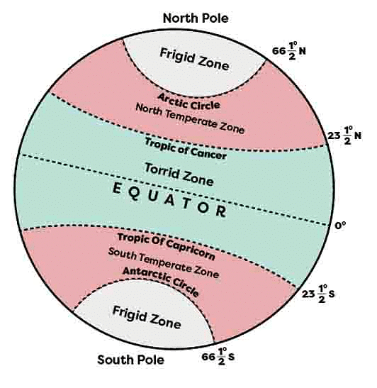 Q6: State the location of the South Pole.
Ans. The South Pole is located at 90°S in the southern hemisphere, opposite to the North Pole.
Q7: The 24 time zones of the Earth are of ______ each.
Ans. 1 hour. The 24 time zones of Earth are each 1 hour wide, allowing us to keep track of time across different regions.
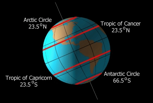
Q8: State the location of the Antarctic Circle.
Ans. Antarctic Circle lies south of the equator at 66½°S, marking the southernmost point where the sun can be seen above the horizon during the summer solstice.
Q9: What is the value of the South Pole?
Ans. 90°S. The South Pole is located at a latitude of 90°S, which means it is situated at the southernmost point on Earth.
Q10: Where does North Temperate Zone lie?
Ans. 23½°N - 66½°N. The North Temperate Zone lies between latitudes 23½°N and 66½°N, encompassing regions with moderate climates in the northern hemisphere.
Q11: The angle of the sun's rays, as it moves toward the poles, increases/decreases.
Ans. Decreases. The angle of the sun's rays decreases as it moves toward the poles. This is because the rays spread over a larger area due to the Earth's curvature, resulting in less direct heat and light reaching the surface.
Q12: Why is the globe important?
Ans. A globe is useful when we want to study the earth as a whole as we can see
(i) The water bodies,
(ii) The axis,
(iii) The tilt and the location of the countries on the globe.
 Globe
Globe
Q13: How can we find the latitude of a place with the help of a pole star?
Ans. By measuring the angle of the pole star, one can find out the latitude of a place.
Q14: What type of climate is found in the Temperate Zone?
Ans. Moderate. The Temperate Zone has a moderate climate, which means it is not too hot or too cold. It is characterized by mild temperatures and distinct seasons.
Q15: How many degrees are there in either of the Hemispheres?
Ans. There are 90 in either of the Hemispheres. Each hemisphere, whether it's the northern hemisphere or the southern hemisphere, covers 90 degrees. These 90 degrees represent the distance from the equator to the North Pole or the South Pole in that hemisphere.
Q16: Where do all the meridians meet?
Ans. At the poles. All the meridians, which are lines of longitude, meet at the poles. This is because the poles are the points of convergence for these lines on Earth's surface.
Q17: When we move from the Equator towards the poles, the distance between the longitudes ______.
Ans. Decreases. When we move from the Equator towards the poles, the distance between the longitudes decreases. This is because the longitudes converge as we move closer to the poles.
Q.18. Where does Torrid Zone lie?
Ans. The Torrid Zone, also known as the tropical zone, lies between the latitudes of 23½°N and 23½°S. It is characterized by hot and humid climates, and it is the region closest to the equator.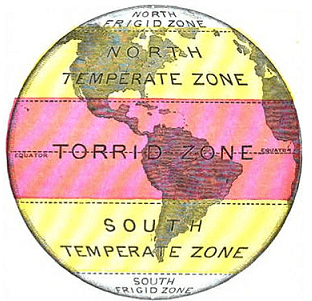 Torrid zonesQ.19. Name the area between the Tropic of Capricorn and the Tropic of Cancer.
Ans. Torrid Zone. The area between the Tropic of Capricorn and the Tropic of Cancer is called the Torrid Zone. It is known for its hot and humid climate.
Q.20. Name the true model of the earth.
Ans. Globe. The true model of the Earth is a globe. It is a three-dimensional representation of the Earth's surface and provides an accurate depiction of its shape.
Q.21. At the poles, the sun's rays are ______.
Ans. Slanting. At the poles, the sun's rays are slanting. This means that the rays of the sun hit the Earth's surface at an angle, resulting in less direct heat and light reaching those regions.
Q.22. What is the importance of the Equator?
Ans. The equator is an important reference point for locating places.
Q.23. Define the axis of a globe.
Ans. A needle is fixed through a globe in a tilted manner called the axis of a globe.
Q.24. Define latitudes.
Ans. The parallel circles from the equator up to the poles are called latitudes.
Q.25. Name the heat zone that receives maximum heat.
Ans. Torrid Zone. This zone, located between the Tropic of Cancer and the Tropic of Capricorn, experiences the most direct and intense sunlight, resulting in high temperatures throughout the year.
Q.26. Why are frigid zones very cold?
Ans. In this zone, the sun does not rise much above the horizon, so its rays are always slanting and provide less heat.
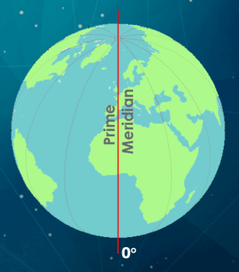
Q.27. What is the value of the Prime meridian?
Ans. 0° longitude. It is the imaginary line of longitude that passes through Greenwich, London, and serves as the reference point for measuring all other longitudes around the world.
 Q.28. If the time is 12 noon in Greenwich, then what is the time at 20° west?
Ans. 10:40 a.m. If the time is 12 noon in Greenwich, then the time at 20° west would be 10:40 a.m. This is because for every 15 degrees of longitude, there is a time difference of 1 hour, and 20 degrees west is 1 hour and 20 minutes behind Greenwich.
Q.29. What is the total number of standard time zones in Russia?
Ans. 11. Russia has a total of 11 standard time zones. Due to its vast geographical extent, Russia spans multiple time zones to accommodate the country's large size.
Q.30. State the Total time zones in which the Earth has been divided.
Ans. 24. The Earth has been divided into a total of 24 time zones. Each time zone represents a specific region with a consistent standard time to facilitate global coordination and synchronization.
Q.31. What does the term 'Grid' mean in Geography?
Ans. The network of the Parallels of Latitude and Meridians of Longitude on the Globe is known as Grid.
Q.32. What is the true shape of the Earth?
Ans. The true shape of Earth is Geoid.
Q.33. Name the different heat zones of the Earth.
Ans. There are mainly three heat zones of the Earth:
(i) Torrid zone.
(ii) Temperate zone.
(iii) Frigid zone.
Q.34. Name the two basic points of reference on the Earth’s surface?
Ans. North Pole & South Pole.
Q.35. How can you locate a point on the globe?
Ans. Any point on the globe can be located by knowing its latitudes & longitudes.
Q.36. What is the standard meridian of India?
Ans. The standard meridian of India is 82°30’E.
Q.37. In which zone do the Poles fall?
Ans. Frigid Zone
Q.38. In which unit are the Longitudes measured?
Ans. The distances between Longitude are measured in ‘degrees of longitude.’ Each degree is further divided into minutes, and minutes into seconds.
Q.39. What happens to the Longitudes at the poles?
Ans. Longitudes are semicircles and the distance between them decreases steadily as they move towards the poles until it becomes zero at the poles, where all the meridians meet.
Q.40. Where is British Royal Observatory is located?
Ans. Greenwich
FAQs on Class 6 Geography Chapter 2 Question Answers - Globe Latitudes and Longitudes
| 1. What are latitudes and longitudes on a globe? |  |
| 2. What is the purpose of using latitudes and longitudes? | |
| 3. What is the difference between latitudes and longitudes? | |
| 4. How many degrees of latitude and longitude are there? | |
| 5. What is the importance of understanding latitudes and longitudes for navigation? | |


Free
,Summary
,Sample Paper
,Extra Questions
,Objective type Questions
,Previous Year Questions with Solutions
,Viva Questions
,shortcuts and tricks
,ppt
,past year papers
,Class 6 Geography Chapter 2 Question Answers - Globe Latitudes and Longitudes
,Class 6 Geography Chapter 2 Question Answers - Globe Latitudes and Longitudes
,mock tests for examination
,video lectures
,Exam
,study material
,practice quizzes
,MCQs
,Class 6 Geography Chapter 2 Question Answers - Globe Latitudes and Longitudes
,Important questions
,Semester Notes
,


Very Short Question Answers: Globe Latitudes & Longitudes Free PDF Download
Importance of Very Short Question Answers: Globe Latitudes & Longitudes
Very Short Question Answers: Globe Latitudes & Longitudes Notes
Very Short Question Answers: Globe Latitudes & Longitudes Class 6 Questions
Study Very Short Question Answers: Globe Latitudes & Longitudes on the App
|
© EduRev
|
Education Revolution
|


|


