Geography of Europe | Famous Books for UPSC Exam (Summary & Tests) PDF Download
EUROPE
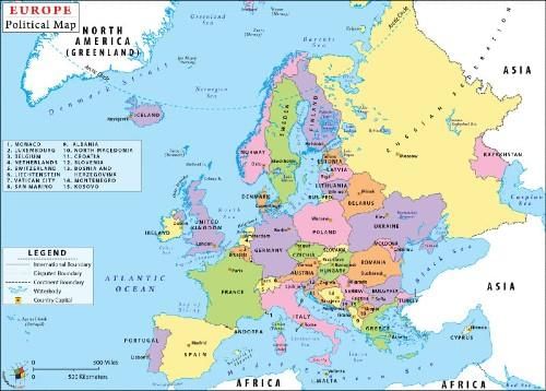
Europe is the second smallest continent, the smallest being Australia. Its area, including the islands around the coast, is about 10 million square kilometers.
It is roughly three times the size of India and smaller than China.

Location Of Europe
- A large part lies in the temperate zone as it stretches from 35°N to 80°N latitude.
- Longitudinally, it stretches from 10°W to 60°E
- The Prime Meridian passes through London.
- In the north, though it stretches into the Arctic Circle, the Warm Gulf Stream keeps the ports ice-free.
- The broad continent shelf on its west provides good fishing grounds and there are sheltered harbors along the indented coastline.
- It has the longest coastline in proportion to size.
Boundaries Of Europe
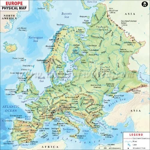
- To the east, it is separated from Asia by the Ural Mountain, Caspian Sea, Caucasus Mountain, and the Black Sea.
- To the south is the Mediterranean Sea. The Aegean Sea and the Adriatic Sea are two of its branches.
- To the west is the Strait of Gibraltar separating Europe from Africa and joining the Mediterranean to the Atlantic Ocean. The Bay of Biscay, the English Channel, and the North Sea are pars of the Atlantic Ocean.
- Baltic Sea with two branches – Gulf of Bothnia and the Gulf of Finland is an inlet in the north. The Arctic Ocean to the north has a bay called the White Sea.
- The peninsula of Greece, known as the Balkan Peninsula and Italy extends into the Mediterranean Sea.
- In the south-west is the Iberian Peninsula which is made up of Spain and Portugal.
- In the north-west is the Scandinavian, Peninsula consisting of Norway and Sweden.

Physical Divisions Of Europe
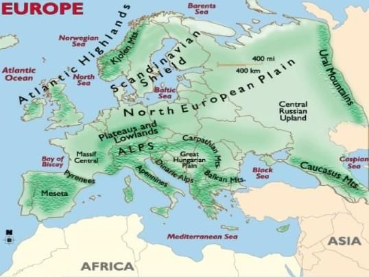
- Western Upland
- North European Plain
- Central Uplands or Plateau
- Alpine Mountain Systems
- Islands of Europe
- Drainage Pattern
- Gulfs and Bays

Western Upland
It is also known as the Northern Highlands, delineate the western edge of Europe and define the physical landscape of Scandinavia (Norway, Sweden, and Denmark), Finland, Iceland, Scotland, Ireland, the Brittany region of France, Spain, and Portugal.
These landforms are result of glaciations of hard rock in the ancient times. Distinct physical features such as marshlands, lakes, and fjords have been emerged with the recession of glaciers form the highland areas.
The famous Norwegian Fjords which are Lyse fjord, the Geiranger fjord.
North European Plain
It is the extensive low land spread along the bank of various mighty rivers such as Rhine, Weser, Elbe, Oder, and Vistula. These river valleys are favorable for growing seasonal crops.
It covers all most half of Europe. Bordered by Baltican White sea from north and Black and Azov from the south the plain is gradually narrowed down towards the west.
The northern part of the land is characterized by diversified glacial landforms such as Pipet Marshland, Valdai hills of western Russia, glacial lakes, etc.
Central Uplands Or Plateau
These are the collection of distinctive landscapes of summits, steep slopes, valleys and depression which stretches across central Europe.
It extends from Belgium in the East to France in the West and from the Czech Republic and south Germany in south to Switzerland and Austria in the North.
Except for some river valleys such as the Rhine, Rhone, Elbe, and Danube river valleys all other areas of this division is sparsely populated.
Alpine Mountain Systems
These are located in south-central Europe, immediately north of the Mediterranean Sea.
They extend for almost 700 miles in a crescent shape from the coastline of southern France (near Monaco) into Switzerland, then through northern Italy and into Austria, and down through Slovenia, Croatia, Bosnia and Herzegovina, Serbia and Montenegro – then ending in Albania on the rugged coastline of the Adriatic Sea.
The highest point is Mont Blanc at 15,771 ft. (4,807m).
|
747 videos|1231 docs|633 tests
|
FAQs on Geography of Europe - Famous Books for UPSC Exam (Summary & Tests)
| 1. What are the major physical features of Europe? |  |
| 2. Which countries are located in Eastern Europe? |  |
| 3. What are the main climate zones in Europe? |  |
| 4. How has the geography of Europe influenced its history? |  |
| 5. What are the major cities in Europe? |  |
|
747 videos|1231 docs|633 tests
|


