NCERT Summary: Land use & Agriculture - 1 | Geography for UPSC CSE PDF Download
Different types of lands are suited to different uses. Human beings thus, use land as a resource for production as well as residence and recreation.
Land-use records maintained by land revenue department. The land use categories add up to reporting area, which is somewhat different from the geographical area. The Survey of India is responsible for measuring geographical area of administrative units in India. The difference between the two concepts are that while the former changes somewhat depending on the estimates of the land revenue records, the latter does not change and stays fixed as per Survey of India measurements.
The land-use categories as maintained in the Land Revenue are as follows: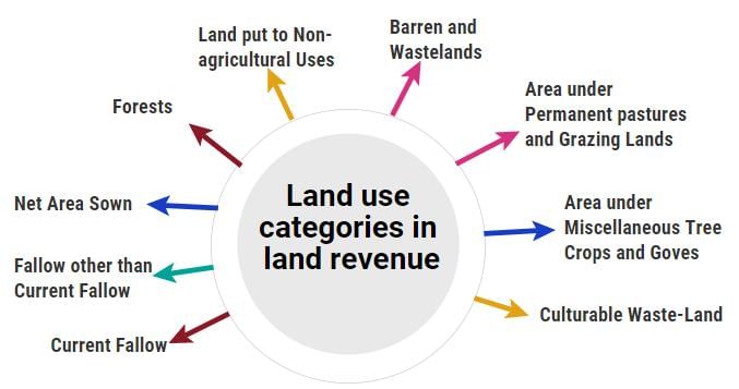
(i) Forests: It is important to note that area under actual forest cover is different from area classified as forest. The latter is the area which the Government has identified and demarcated for forest growth. The land revenue records are consistent with the latter definition. Thus, there may be an increase in this category without any increase in the actual forest cover.
(ii) Land put to Non-agricultural Uses: Land under settlements (rural and urban), infrastructure (roads, canals, etc.), industries, shops, etc. are included in this category. An expansion in the secondary and tertiary activities would lead to an increase in this category of land-use.
(iii) Barren and Wastelands: The land which may be classified as a wasteland such as barren hilly terrains, desert lands, ravines, etc. normally cannot be brought under cultivation with the available technology.
(iv) Area under Permanent pastures and Grazing Lands: Most of this type land is owned by the village ‘Panchayat’ or the Government. Only a small proportion of this land is privately owned. The land owned by the village panchayat comes under ‘Common Property Resources’.
(v) Area under Miscellaneous Tree Crops and Goves (Not included is Net sown Area): The land under orchards and fruit trees are included in this category. Much of this land is privately owned.
(vi) Culturable Waste-Land: Any land which is left fallow (uncultivated) for more than five years is included in this category. It can be brought under cultivation after improving it through reclamation practices.
(vii) Current Fallow: This is the land which is left without cultivation for one or less than one agricultural year, Fallowing is a cultural practice adopted for giving the land rest. The land recoups lost fertility through natural processes.
(viii) Fallow other than Current Fallow: This is also a cultivable land which is left uncultivated for more than five years, it would be categorized as culturable wasteland.
(ix) Net Area Sown: The physical extent of land on which crops are sown and harvested is known as net sown area.
Land-use Changes in India
Land-use in a region, to a large extent, is influenced by the nature of economic activities carried out in the region. However, while economic activities change over time, land, like many other natural resources, is fixed in terms of its area. At this stage, one needs to appreciate three types of changes that an economy undergoes, which affect land-use.
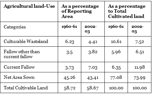
India has undergone major changes within the economy over the past four or five decades, and this has influenced the land-use changes in the country, These changes between 1960-61 and 2002-03 have been shown in Fig. There are two points that you need to remember before you derive some meaning from this figure. Firstly, the percentage shown in the figure have been derived with respect to the reporting area.
Secondly, since even the reporting area has been relatively constant over the years, a decline in one category usually leads to an increase in some other category.
Three categories have undergone increases, while four have registered declines. Share of area under forest, are under nonagricultural uses and current fallow land have shown an increase. The following observations can be made about these increases:
(i) The rate of increase is the highest in case of area under non-agricultural uses. This is due to the changing structure of Indian economy, which is increasingly depending on the contribution from industrial and services sectors and expansion of related infrastructural facilities. Also, an expansion of area under both urban and rural settlements has added to the increase. Thus, the area under non-agricultural uses is increasing at the expense of wastelands and agricultural land.
(ii) The increase in the share under forest, as explained before, can be accounted for by increase in the demarcated area under forest rather than an actual increase in the forest cover in the country.
(iii) The increase in the current fallow cannot be explained from information pertaining to only two points. The trend of current fallow fluctuates a great deal over years, depending on the variability of rainfall and cropping cycles.
The four categories that have registered a decline are barren and wasteland, culturable wasteland, area under pastures and tree crops and net area sown.
The following explanations can be given for the declining trends:
(i) As the pressure on land increased, both from the agricultural and nonagricultural sectors, the wastelands and culturable wastelands have witnessed decline over time.
(ii) The decline in net area sown is a recent phenomenon that started in the late nineties, before which it was registering a slow increase. There are indications that most of the decline has occurred due to the increases in area under nonagricultural use.
(Note: the expansion of building activity on agricultural land in your village and city).
(iii) The decline in land under pastures and grazing lands can be explained by pressure from agricultural land. Illegal encroachment due to expansion of cultivation on common pasture lands is largely responsible for this decline.
Agricultural Land Use in India
Land resource is more crucial to the livelihood of the people depending on agriculture:
(i) Agriculture is a purely land based activity unlike secondary and tertiary activities. In other words, contribution of land in agricultural output is more compared to its contribution in the outputs in the other sectors. Thus, lack of access to land is directly correlated with incidence of poverty in rural areas.
(ii) Quality of land has a direct bearing on the productivity of agriculture, which is not true for other activities.
(iii) In rural areas, aside from its value as a productive factor, land ownership has a social value and serves as a security for credit, natural hazards or life contingencies, and also adds to the social status.
An estimation of the total stock of agricultural land resources (i.e. total cultivable land can be arrived at by adding up net sown area, all fallow lands and culturable wasteland. It may be observed from Table that over the years, there has been a marginal decline in the available total stock of cultivable land as a percentage to total reporting area. There has been a greater decline of cultivated land, in spite of a corresponding decline of cultivable wasteland.
CROPPING SEASONS IN INDIA: 
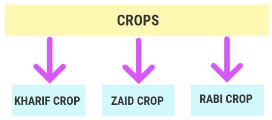
There are three distinct crop seasons in the northern and interior parts of country, namely kharif, rabi and zaid. The kharif season largely coincides with Southwest Monsoon under which the cultivation of tropical crops such as rice, cotton, jute, jowar, bajra and tur is possible. The rabi season begin with the onset of winter in October-November and ends in March-April. The low temperature conditions during this season facilitate the cultivation of temperate and subtropical crops such as wheat, gram and mustard. Zaid is a short duration summer cropping season beginning after harvesting of rabi crops. The cultivation of watermelons, cucumbers, vegetables and fodder crops during this season is done on irrigated lands. However, this type of distinction in the cropping season does not exist in southern parts of the country. Here, the temperature is high enough to grow tropical crops during any period in the year provided the soil moisture is available. Therefore, in this region same crops can be grown thrice in an agricultural year provided there is sufficient soil moisture.
Primitive Subsistence Farming
Based upon the characteristics of physical environment technology and sociocultural practices following farming system can be identified.
This type of farming is still practiced in few pockets of India. Primitive subsistence agriculture is practiced on small patches of land with the help of primitive tools like hoe, dao and digging sticks, and family/ community labour. This type of farming depends upon monsoon, natural fertility of the soil and suitability of other environment conditions to the crops grown.
It is a ‘slash and burn’ agriculture. Farmers clear a patch of land and produce cereals and other food crops to sustain their family. When the soil fertility decreases, the farmers shift and clear a fresh patch of land for cultivation. This type of shifting allows Nature to replenish the fertility of the soil through natural processes; land productivity in this type of agriculture is low as the farmer does not use fertilizers or other modern inputs. It is known by different names in different parts of the country. It is jhumming in north-eastern states like Assam, Meghalaya, Mizoram and Nagaland; Pamlou in Manipur, Dipa in Bastar district of Chattishgarh, and in Andaman and Nicobar Islands.
Jhumming: The ‘slash and burn’ agriculture is known as ‘Milpa’ in Mexico and Central America, ‘Conuco’ in Venzuela, ‘Roca’ in Brazil, ‘Masole’ in Central Africa, ‘Ladang’ in Indonesia, ‘Ray’ in Vietnam.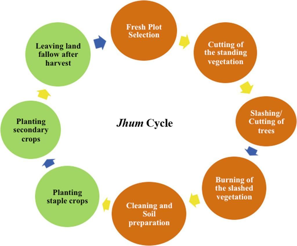
In India, this primitive form of cultivation is called ‘Betwar’ or ‘Dahiya’ in Madhya Pradesh, ‘Podu’ or ‘Penda’ in Andhra Pradesh, ‘Pama Dabi’ or ‘Koman’ or ‘Bringa’ in Orissa, ‘Kumari’ in Western Ghats, ‘Valre’ in South-Eastern Rajasthan, ‘Khil’ in the Himalayan belt, ‘Kuruwa’ in Jharkhand, and ‘Jhumming’ in the North-Eastern region.
Intensive Substance Farming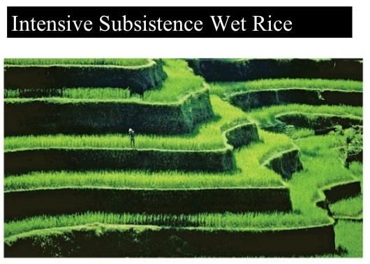 This type of farming is practiced in areas of high population pressure on land. It is labour intensive farming, where high doses of biochemical inputs and irrigation are used for obtaining higher production. Though the ‘right of inheritance’ leading to the division of land among successive generations has rendered land-holding size uneconomical, the farmers continue to take maximum output from the limited land in the absence of alternative source of livelihood. Thus, there is enormous pressure on agricultural land.
Commercial Farming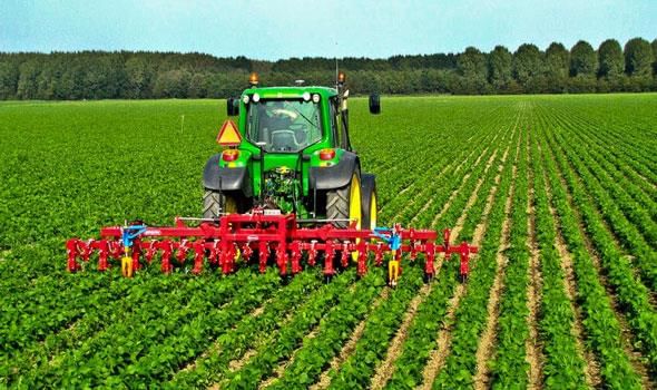
Commercial farming
The main characteristic of this type of farming is the use of higher doses of modern inputs, Example: high yielding variety (HYV) seeds, chemical fertilizers, insecticides and pesticides in order to obtain higher productivity. The degree of commercialization of agriculture varies from one region to another. For example, rice is a commercial crop in Haryana and Punjab, but in Orissa, it is a subsistence crop. Plantation is also a type of commercial farming. In this type of farming, a single crop is grown on a large area. The plantation has an interface of agriculture and industry. Plantations cover large tracts of land, using capital intensive inputs, with the help of migrant laboures. All the produce is used as raw material in respective industries.
Types of Farming
On the basis of main source of moisture for crops, the farming can be classified as irrigated and rainfed (barani). 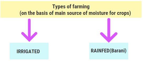 There is difference in the nature of irrigated farming as well based on objective of irrigation, i.e. protective or productive. The objective of protective irrigation is to protect the crops from adverse of soil moisture deficiency which often means that irrigation acts as a supplementary source of water over and above the rainfall. The strategy of this kind of irrigation is to provide soil moisture to maximum possible area. Productive irrigation is meant to provide sufficient soil moisture in the cropping season to achieve high productivity. In such irrigation the water input per unit area of cultivated land is higher than protective irrigation. Rainfed farming is further classified on the basis of adequacy of soil moisture during cropping season into dry land and wetland farming. In India, the dry land farming is largely confined to the regions having annual rainfall less than 75 cm. These regions grow hardy and drought resistant crops such as ragi, bajra, moong, gram and guar (fodder crops) and practice various measures of soil moisture conservation and rain water harvesting. In wetland farming, the rainfall is in excess of soil moisture requirement of plants during rainy season. Such regions may face flood and soil erosion hazards. These areas grow various water intensive crops such as rice, jute and sugarcane and practice aquaculture in the fresh water bodies.
CROPPING PATTERN
Food grains: The importance of food grains in Indian agricultural economy may be gauged from the fact these crops occupy about two-third of total cropped area in the country. Food grains are dominant crops in all parts of the country whether they have subsistence or commercial agricultural economy. On the basis of the structure of grain the food grains are classified as cereals and pulses.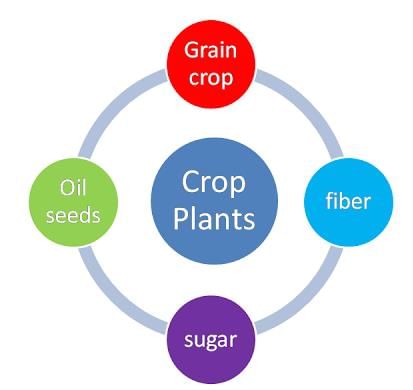
Cereals: The cereals occupy about 54 per cent of total cropped area in India. The country produces about 11 per cent cereals of the world and ranks third in production after China and U.S.A. India produces a variety of cereals, which are classified as fine grains (rice, wheat) and coarse grains (jowar, maize, ragi) etc. Account of important cereals has been given in the following paragraphs.
Rice: Rice is a staple food for the overwhelming majority of population in India. Though, it is considered to be a crop of tropical humid areas, it has about 3,000 varieties which are grown in different agroclimatic regions. These are successfully grown from sea level to about 2,000 m altitude and from humid areas in eastern India to dry but irrigated areas of Punjab, Haryana, western U.P. and northern Rajasthan. In southern states and West Bengal the climatic conditions allow the cultivation of two or three crops of rice in an agricultural year. In West Bengal farmers grow three crops of rice called ‘aus’, ‘aman’ and ‘boro’. But in Himalayas and northwestern parts of the country, it is grown as a Kharif crop during southwest Monsoon season.
India contributes 22 per cent of rice production in the world and ranks second after China. About one-fourth of the total cropped area in the country is under rice cultivation. West Bengal, Punjab, Uttar Pradesh, Andhra Pradesh and Tamil Nadu were five leading rice producing states in the country in 2002-03. The yield level of rice is high in Punjab, Tamil Nadu. Andhra Pradesh, West Bengal and Kerala. In the first four of these states almost the entire land under rice cultivation is irrigated. Punjab and Haryana are not traditional rice growing areas. Rice cultivation in the irrigated areas of Punjab and Haryana was introduced in 1970s following the Green Revolution. Generally improved varieties of seed, relatively high usage of fertilizers and pesticides and lower levels of susceptibility of the crop to pests due to dry climatic conditions are responsible for higher yield of rice in this region. The yield of this crop is very low in rainfed areas of Madhya Pradesh, Chhattisgarh and Orissa.
Wheat: Wheat is the second most important cereal crop in India after rice. India produces about 12 per cent of total wheat production of world. It is primarily a crop of temperate zone. Hence, its cultivation in India is done during winter i.e. rabi season. About 85 per cent of total area under this crop is concentrated in north and central regions of the country i.e. Indo-Gangetic Plain, Malwa Plateau and Himalayas up to 2,700 m altitude. Being a rabi crop, it is mostly grown under irrigated conditions. But it is rainfed crop in Himalayan highlands and parts of Malwa plateau in Madhya Pradesh. About 14 per cent of the total cropped area in the country is under wheat cultivation. Uttar Pradesh, Punjab, Haryana, Rajasthan and Madhya Pradesh are five leading wheat producing states. The yield level of wheat is very high (above 4,000 k.g. per ha) in Punjab and Haryana whereas, Uttar Pradesh, Rajasthan and Bihar have moderate yields. The states like Madhya Pradesh, Himachal Pradesh and Jammu and Kashmir growing wheat under rainfed conditions have low yield.
|
175 videos|472 docs|197 tests
|
FAQs on NCERT Summary: Land use & Agriculture - 1 - Geography for UPSC CSE
| 1. What is land use and agriculture? |  |
| 2. How does land use affect agriculture? |  |
| 3. What are the different types of land use in agriculture? |  |
| 4. How does land use affect the environment? |  |
| 5. What are the challenges faced in land use and agriculture? |  |

|
Explore Courses for UPSC exam
|

|
