Rotation and Revolution | Geography for UPSC CSE PDF Download
| Table of contents |

|
| Rotation |

|
| Revolution |

|
| 21st June/ Summer Solstice |

|
| 22nd December/ Winter Solstice |

|
| Equinox |

|
| Prime meridian |

|
| Antarctic Circle |

|
| Equator |

|
| Tropic of Cancer and Tropic of Capricorn |

|
Rotation
- Movement of the earth on its axis.
- Earth rotates along its axis from west to east.
- It takes approximately 24 hrs(23hr 56min 4 sec) to complete on rotation.
- Days and nights occur due to rotation of the earth.
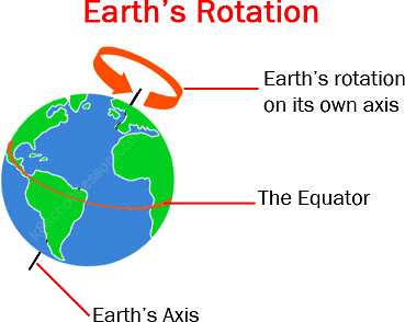
- The circle that divides the day from night on the globe is called the circle of illumination.
- Earth rotates on a tilted axis. Earth’s rotational axis makes an angle of 23.5° with the normal, i.e. it makes an angle of 66.5° with the orbital plane. Orbital plane is the plane of earth’s orbit around the Sun.
Revolution
- Movement of the earth around the sun in a fixed path or orbit.
- It takes 365¼ days (one year) to revolve around the sun.
- Six hours saved every year are added to make one day (24 hours) over a span of four years. This surplus day is added to February. Thus, every fourth year, February is of 29 days instead of 28 days. Such a year with 366 days is called a leap year.
Orbital plane: Axis of the earth, an imaginary line makes an angle of 66½° with its orbital plane. The plane formed by the orbit is known as the orbital plane.
21st June/ Summer Solstice
- The Northern Hemisphere is tilted towards the sun, and the rays of the sun fall directly on the Tropic of Cancer → areas receive more heat.
- Areas near the poles receive less heat as the rays of the sun are slanting.
- The North Pole is inclined towards the sun and the places beyond the Arctic Circle experience continuous daylight for about six months.
- Since a large portion of the Northern Hemisphere is getting light from the sun, it is summer in the equator regions. The longest day and the shortest night at these places occur on 21st June.
- Southern Hemisphere: All these conditions are reversed (winter season- longer nights)
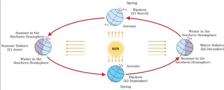 Revolution of Earth and Seasons
22nd December/ Winter Solstice
- The Tropic of Capricorn receives direct rays of the sun as the South Pole tilts towards it.
- As the sun’s rays fall vertically at the Tropic of Capricorn (23½° S), a larger portion of the Southern Hemisphere gets light. Therefore, it is summer in the Southern Hemisphere with longer days and shorter nights.
- The reverse happens in the Northern Hemisphere.
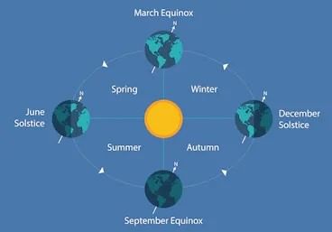
Equinox
- On 21st March and September 23rd, direct rays of the sun fall on the equator. Neither of the poles is tilted towards the sun; so, the whole earth experiences equal days and equal nights. This is called an equinox.
- 23rd September: Autumn season in the Northern Hemisphere and spring season in the Southern Hemisphere.
- 21st March: Spring in the Northern Hemisphere and autumn in the Southern Hemisphere.
- Thus, you find that there are days and nights and changes in the seasons because of the earth's rotation and revolution, respectively.
Prime meridian
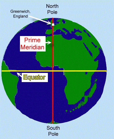
A prime meridian is a meridian (a line of longitude) in a geographical coordinate system at which longitude is defined to be 0°. Together, a prime meridian and its anti-meridian (the 180th meridian in a 360°-system) form a great circle. This great circle divides the sphere, e.g., the Earth, into two hemispheres. If one uses East and West directions from a defined prime meridian, they can be called Eastern Hemisphere and Western Hemisphere.
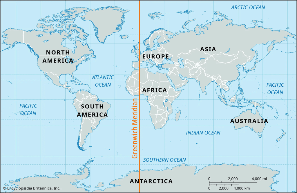
A prime meridian is ultimately arbitrary, unlike an equator determined by the axis of rotation—and various conventions have been used or advocated in different regions and throughout history. The most widely used modern meridian is the IERS Reference Meridian. It is derived but deviates slightly from the Greenwich Meridian, which was selected as an international standard in 1884.
Antarctic Circle
The Antarctic Circle is one of the five major circles or parallels of latitude that marks the Earth's maps.
- It is at latitude 66 degrees 33′ 39″ south of the equator (in 2000; like its northern counterpart, the Arctic Circle, the value is currently slowly decreasing over time, pushing the Antarctic Circle southwards with about 15 m per year).
- For everywhere within the Antarctic Circle, there are at least twenty-four hours of continuous daylight on the Summer Solstice in December and at least twenty-four hours of continuous night time on the Winter Solstice in June.
- That is to say, one whole day during which the sun does not set, and one whole day during which the sun does not rise.
- This is because the earth is tilted at a 23.5-degree angle, and during the winter solstice, the southern hemisphere is tilted away from the Sun, meaning that the Antarctic Circle is completely tilted away from the Sun. Hence it experiences 24 hours a night time and vice versa.
- The Antarctic Circle is a parallel of latitude on the Earth at approximately 66.5 degrees south of the equator. On the day of the southern summer solstice (around December 22 each year), an observer on the Antarctic Circle will see the Sun above the horizon for a full 24 hours.
- Observers further south than the Antarctic Circle will see the Sun remain above the horizon for many days, and at the South Pole, there is a six-month ‘day’ that starts on the autumn equinox changing to a six-month ‘night’ on the vernal equinox.
- The 66.5-degree angle comes from the tilt of the Earth’s rotation axis (23.5°), such that 90° – 23.5° = 66.5°.
Three of the most significant imaginary lines running across the Earth's surface are the Equator, the Tropic of Cancer, and the Tropic of Capricorn.
While the equator is the longest line of latitude on the Earth (the line where the Earth is widest in an east-west direction), the tropics are based on the sun’s position with the Earth at two points of the year. All three lines of latitude are significant in their relationship between the Earth and the sun.
Equator
The equator is located at zero degrees latitude. The equator runs through Indonesia, Ecuador, northern Brazil, the Democratic Republic of the Congo, and Kenya, among other countries. It is 24,901.55 miles (40,075.16 kilometres) long. On the equator, the sun is directly overhead at noon on the two equinoxes – near March and September 21. The equator divides the planet into the Northern and Southern Hemispheres. On the equator, the day and night's length is equal every day of the year-day is always twelve hours long and night is always twelve hours long.
Tropic of Cancer and Tropic of Capricorn
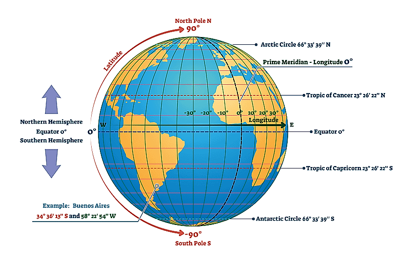
- The Tropic of Cancer and the Tropic of Capricorn each lie at 23.5 degrees latitude. The Tropic of Cancer is located at 23.5° North of the equator and runs through Mexico, the Bahamas, Egypt, Saudi Arabia, India, and southern China. The Tropic of Capricorn lies at 23.5° South of the equator and runs through Australia, Chile, southern Brazil (Brazil is the only country that passes through both the equator and a tropic), and northern South Africa.
- The tropics are the two lines where the sun is directly overhead at noon on the two solstices – near June and December 21. The sun is directly overhead at noon on the Tropic of Cancer on June 21 (the beginning of summer in the Northern Hemisphere and winter in the Southern Hemisphere). The sun is directly overhead at noon on the Tropic of Capricorn on December 21 (the beginning of winter in the Northern Hemisphere and the beginning of summer in the Southern Hemisphere).
- The Tropic of Cancer's location and the Tropic of Capricorn at 23.5° north and south are due to the Earth's axial tilt. The Earth is tilted 23.5 degrees from the plane of the Earth’s revolution around the sun each year.
- The area bounded by the Tropic of Cancer on the north and Tropic of Capricorn on the south is known as the “tropics.” This area does not experience seasons because the sun is always high in the sky. Only higher latitudes, north of the Tropic of Cancer and south of the Tropic of Capricorn, experience significant seasonal variation in climate. Realize, however, that areas in the tropics can be cold. Mauna Kea's peak on the big island of Hawaii stands nearly 14,000 feet above sea level, and snow is not unusual.
- If you live north of the Tropic of Cancer or south of the Tropic of Capricorn, the sun will never be directly overhead. For example, in the United States, Hawaii is the only location south of the Tropic of Cancer. Thus, it is the only location in the United States where the sun will be directly overhead in the summer.Question for Rotation and RevolutionTry yourself:Which one of the following has a geographical position of 0° latitude and 0° longitude?View Solution
Daylight saving in some temperate regions
- Daylight saving time (DST) or summer time is the practice of advancing clocks during summer months by one hour.
- In DST, evening time is increased by sacrificing the morning hours.
Normal days = Start office at 10 AM and close at 5 PM.
In DST = Advance clock by one hour (can be more) = Start office at 9 AM and Close at 4 PM]
- Typically, users in regions with summertime (Some countries in extreme north and south) adjust clocks forward one hour close to the start of spring and adjust them backwards in the autumn to standard time.
- Advantage: Putting clocks forward benefits retailing, sports, and other activities that exploit sunlight after working hours. Reduces evening use of incandescent lighting, which was formerly a primary use of electricity.
- Problems: DST clock shifts sometimes complicate timekeeping and can disrupt travel, billing, record keeping, medical devices, heavy equipment, and sleep patterns.
|
269 videos|870 docs|231 tests
|
FAQs on Rotation and Revolution - Geography for UPSC CSE
| 1. What is the difference between rotation and revolution? |  |
| 2. What occurs during the summer solstice and winter solstice? |  |
| 3. What are equinoxes and when do they occur? |  |
| 4. What is the significance of the Prime Meridian? |  |
| 5. What are the Tropic of Cancer and Tropic of Capricorn? |  |


