Indian Geographical Extent & Frontiers


Indian Geographical Extent and Frontiers
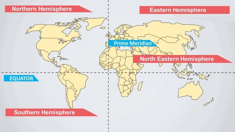
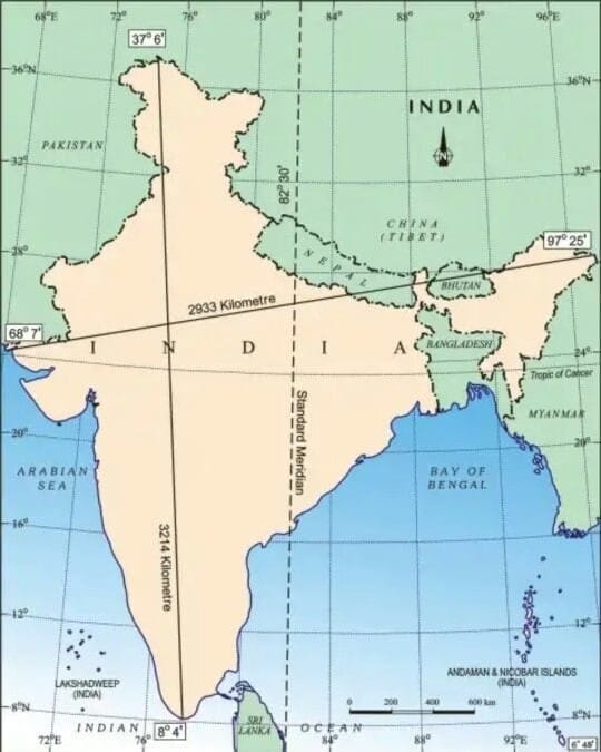
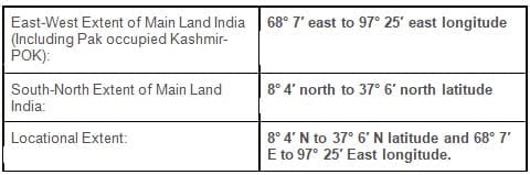
India is located entirely in the northern hemisphere in the south-central part of the continent of Asia. The mainland of India lies between latitudes 8°4′N and 37°6′N and longitudes 68°7′E and 97°25′E. As the seventh-largest country in the world, India forms a distinct geographical entity separated from much of continental Asia by mountains and bounded by the sea on three sides.
India has a land boundary of about 15,106.7 km and a total coastline length of 7,516.6 km, which includes the coastlines of the mainland and the island territories (Andaman & Nicobar and Lakshadweep). The mainland tapers south of about 22°N into a peninsula that divides the Indian Ocean into the Arabian Sea on the west and the Bay of Bengal on the east.
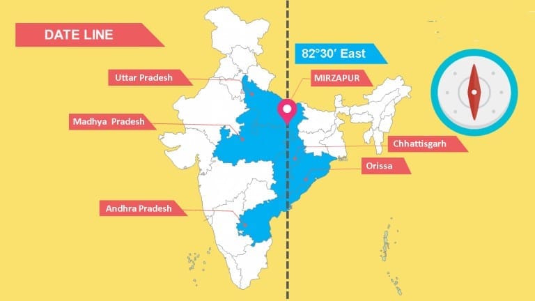
The latitudinal and longitudinal span of the mainland is roughly 30°. Despite this, the north-south extent is larger than the east-west extent. From Gujarat in the west to Arunachal Pradesh in the east there is nearly a two-hour local time difference. Hence the time along the Standard Meridian of India (82°30′E) passing through Mirzapur (Uttar Pradesh) is taken as the Indian Standard Time (IST) for the entire country. Latitudinal extent influences day-length and seasonal temperature variations as one moves from south to north.
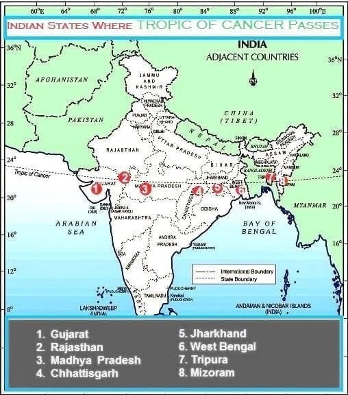
The Tropic of Cancer passes through eight Indian states: Gujarat (near Jasdan), Rajasthan (Kalinjarh), Madhya Pradesh (Shajapur), Chhattisgarh (Sonhat), Jharkhand (Lohardaga), West Bengal (Krishnanagar), Tripura (Udaipur) and Mizoram (Champhai).
Size and Extent
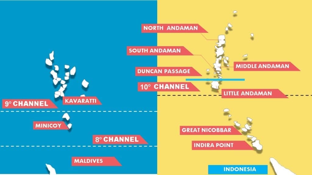
- The southernmost point of India (Indira Point, formerly Pygmalion Point) is at 6°45′N.
- North-south distance from Indira Col in the north (Kashmir) to Kanyakumari in the south is about 3,214 km.
- East-west width from the Rann of Kachchh in the west to the eastern extremity of Arunachal Pradesh is approximately 2,933 km.
- India's total area is about 3,287,263 sq km, making it the seventh-largest country in the world and accounting for roughly 2.4% of the Earth's surface area.
- The Tropic of Cancer passes approximately through the middle of the country, dividing India into two latitudinal halves. The area north of the Tropic of Cancer is nearly twice that of the area south of it.
- South of 22°N the peninsula narrows over roughly 800 km into the Indian Ocean.
Coastline of India
India's coast extends for 7,516.6 km and the coastal plains are present on both the eastern and western seaboards. These coastal plains are economically important for agriculture, fisheries, ports and tourism. The two main coastal divisions are:
- Eastern Coastal Plains
- Western Coastal Plains
Eastern Coastal Plains
The eastern coastal plain stretches from West Bengal in the north to Tamil Nadu in the south, passing through Odisha and Andhra Pradesh. Major river deltas-of the Mahanadi, Godavari, Krishna and Kaveri-occur here, creating broad, fertile plains suitable for intensive agriculture. The delta of the Krishna is often referred to as the Granary of South India.
The eastern coast is commonly subdivided into three coastal segments:
- Utkal Coast: Extends between Chilika Lake (Odisha) and Kolleru Lake (Andhra). It is broad and receives heavy rainfall; important crops include rice, coconut and banana.
- Andhra Coast: Extends between Kolleru Lake and Pulicat Lake. This segment forms the large basin areas for the Godavari and Krishna rivers.
- Coromandel Coast: Extends from Pulicat Lake down to Kanyakumari. It is relatively dry in summer and receives rainfall during the northeast monsoon.
Chilka Lake and Pulicat Lake (a lagoon) are the two important coastal features of the eastern coastline.
Western Coastal Plains
The western coastal plain extends from Gujarat and Kachchh in the north to Kerala in the south, passing through Maharashtra, Goa and Karnataka. The western coast is generally narrower than the eastern coast, with an average width of about 10-25 km along much of its length and a north-south coastal length of roughly 1,500 km. Off the Bombay coast the continental shelf is relatively wide and petroleum prospects exist there. The Malabar coast in the south is known for lagoons and backwaters.
The western coast can be subdivided into four segments:
- Kachchh and Kathiawar Coast: Kachchh (Great Rann and Little Rann) is a shallow lagoon-like area formed by silt deposition; Kathiawar (Saurashtra) lies to its south.
- Konkan Coast: Runs from Daman to Goa; paddy (rice) and cashew are important crops.
- Canara (Karnataka) Coast: Extends from Marmagao to Mangalore and is known for fishing and some iron ore bearing regions.
- Malabar Coast: Extends from Mangalore to Kanyakumari and includes the lagoons and backwaters of southern Kerala.
Konkan is commonly used for the stretch along Maharashtra and Goa, while Malabar denotes the coast of Karnataka and Kerala in common usage.
Standard Time (Time Zone)
Longitude is used to measure time differences from the Prime Meridian (0°) at Greenwich, which defines the reference for Coordinated Universal Time (UTC). Each 15° of longitude corresponds to a one-hour difference in solar time.
For example: At 150°W longitude, local time is 150° ÷ 15° = 10 hours behind UTC (UTC-10).
India uses the meridian 82°30′E as the reference for Indian Standard Time (IST), which is UTC+5:30. The Indian Standard Meridian (82°30′E) runs through parts of Uttar Pradesh, Madhya Pradesh, Chhattisgarh, Odisha and Andhra Pradesh.
India - Tropical or Temperate Country?
- The temperate part (north of the Tropic of Cancer) is about twice the area of the tropical part.
- Nevertheless, India is commonly treated as a tropical country for two broad reasons: physical-geographical and cultural-geographical factors.
Physical-Geographical Reasons
- The Himalayas separate peninsular India from much of the rest of Asia and block temperate air masses from penetrating the subcontinent.
- The climate of India is dominated by the tropical monsoon system; monsoonal winds and the seasonal reversal of winds strongly influence rainfall patterns.
- Although winter night temperatures in parts of North India can fall to levels typical of temperate lands, clear skies and strong solar radiation during the day produce daily temperatures that are characteristic of tropical regions.
Cultural-Geographical Reasons
- Patterns of settlement, agriculture (crops and calendar), disease environment and many primary economic activities in India correspond to tropical systems in practice.
India's Frontiers
- India has a land boundary of 15,106.7 km running through 92 districts across 17 States and a coastline of 7,516.6 km (comprising approximately 6,100 km of mainland coastline and about 1,197 km of island coastlines), touching 13 States and Union Territories.
- Except for Madhya Pradesh, Chhattisgarh, Jharkhand, Delhi, Haryana and Telangana, most Indian States have either an international border or a coastline and are thus frontline States from the perspective of border management.
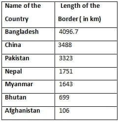
- India's longest land border is with Bangladesh and the shortest is with Afghanistan.
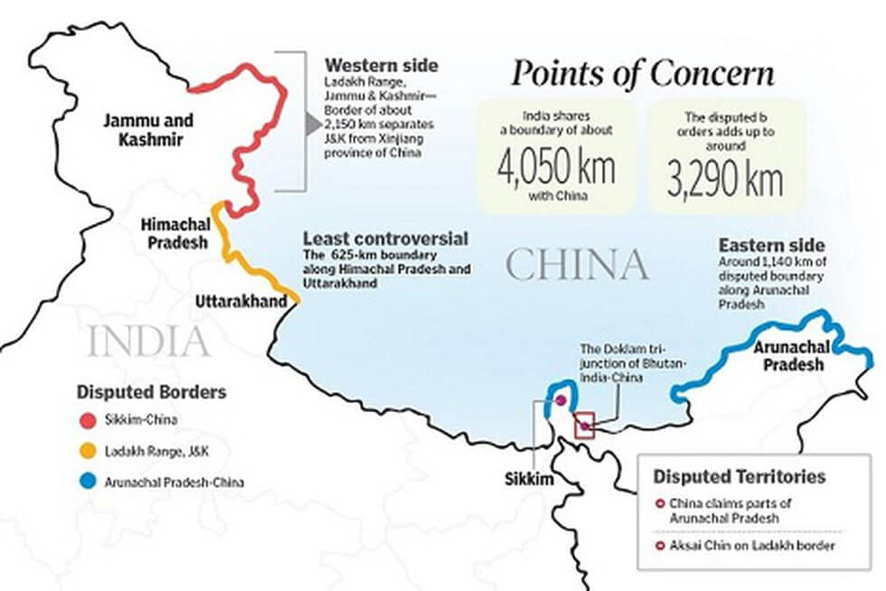
Border with China
- The India-China border is India's second-longest international boundary after Bangladesh.
- Five Indian states touch this international boundary: Jammu & Kashmir (Ladakh), Himachal Pradesh, Uttarakhand, Sikkim and Arunachal Pradesh.
- The Sino-Indian boundary is generally divided into three sectors: the Western, Middle and Eastern sectors.
The Western Sector
- Separates the Union Territory of Ladakh (India) from the Xinjiang (Sinkiang) province of China.
- This sector largely reflects legacy decisions and ambiguities arising from the British colonial administration's frontier policies.
- China claims the Aksai Chin plateau, parts of the Chang Chenmo (Changmo) valley, Pangong Tso and Spanggur Tso regions of eastern Ladakh. China also claims parts of the former Huzā-Gilgit area that were subject to other mid-20th century arrangements.
The Middle Sector
- This sector is touched by the Indian states of Himachal Pradesh and Uttarakhand and follows the Himalayan watershed; there is relatively little dispute in this stretch.
The Eastern Sector
- The eastern sector boundary runs from Bhutan's eastern limit to the trijunction near the Talu (Diphu) Pass where India, Tibet and Myanmar meet; it is often referred to by the name of the McMahon Line.
- The McMahon Line was drawn during the Simla Convention of 1913-14, negotiated by Sir Henry McMahon between British India and Tibet. China regards the McMahon Line as invalid on the basis that Tibet was not empowered to conclude such an agreement.
The India-Nepal Boundary
- Five Indian states touch Nepal: Uttarakhand, Uttar Pradesh, Bihar, West Bengal and Sikkim. The border is porous, with considerable cross-border movement of people and goods.
- A large part of the Indo-Nepal boundary runs roughly east-west along the foothills of the Shiwalik Range.
Disputed Areas between India and Nepal
- Kalapani: A valley administered by India as part of Pithoragarh district in Uttarakhand. It lies on the route to Kailash-Mansarovar. The dispute stems from differing interpretations of the Kali (Mahakali) River source as defined in the Treaty of Sugauli (1816) signed between Nepal and British India after the Anglo-Nepalese War. Each country's maps assert the source differently, producing competing territorial claims.
- Susta: Located on the banks of the Gandak (Narayani) river, disputes over Susta relate primarily to changes in the river's course and the consequent shifting of riverine boundaries.
The India-Bhutan Boundary
- The India-Bhutan border is generally peaceful with no major boundary disputes.
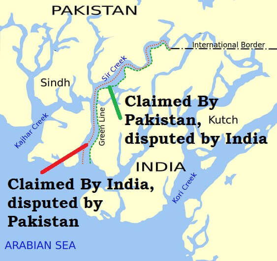
The Indo-Pakistan Boundary
- The Indo-Pakistan land boundary largely resulted from the partition of British India in 1947 and the Radcliffe Award, named for Sir Cyril Radcliffe who chaired the boundary commission.
- Major disputed regions include Jammu & Kashmir and the maritime area in the Sir Creek region of the Rann of Kachchh.
Disputed Territories with Pakistan
- Jammu & Kashmir (PoK and Gilgit-Baltistan): Pakistan occupies approximately 78,000 sq km of territory that India claims as part of the former state of Jammu & Kashmir. Under the Sino-Pakistan Agreement (1963), territories in Pakistan-occupied Kashmir were part of a boundary settlement with China.
- Siachen Glacier: Located in the eastern Karakoram near the Actual Ground Position Line (AGPL). India has exercised administrative and military control over most of the Siachen area since Operation Meghdoot (1984).
- Saltoro Ridge: A key mountain range adjacent to Siachen; India controls the main peaks and passes on the Saltoro Ridge, while Pakistani forces are positioned to the west in glacial valleys. Both countries claim the broader Jammu & Kashmir region.
- Sir Creek: A tidal estuary in the Rann of Kachchh about 96 km long; India and Pakistan disagree over the maritime boundary interpretation. Pakistan argues the boundary follows the eastern shore; India asserts a centre-line demarcation. The land boundary and the International Maritime Boundary Line (IMBL) in this area have not been mutually finalised.
The India-Bangladesh Boundary
- India's border with Bangladesh is approximately 4,096 km, the longest land boundary India shares with any country.
- This boundary was delineated under the Radcliffe Award that partitioned the former province of Bengal between India and Pakistan in 1947. Subsequent bilateral agreements and exchanges have adjusted some local areas and enclaves.
Try yourself: Which region is disputed between India and Pakistan?
The India-Myanmar Boundary
- The India-Myanmar border runs roughly along the watershed between the Brahmaputra basin and the Ayeyarwady (Irrawaddy) basin.
- On the Indian side the border crosses the Mizo Hills, Manipur and Nagaland, while on the Myanmar side it traverses the Chin Hills, Naga Hills and Kachin regions. Much of this boundary passes through thickly forested and hilly terrain.
The India-Sri Lanka Boundary
- India and Sri Lanka are separated by narrow stretches of sea; the Palk Strait lies between the southeastern Indian coast and Sri Lanka.
- Dhanushkodi on the Tamil Nadu coast is approximately 32 km from Talaimannar on Sri Lanka's Jaffna peninsula. A chain of shoals and islets, known as Adam's Bridge, links these two coasts.
- India and Sri Lanka resolved several maritime and territorial issues through bilateral agreement; one notable settlement occurred when India ceded Kachchatheevu Island to Sri Lanka in 1974.
Do you Know:
The Equator passes through 13 countries: Ecuador, Colombia, Brazil, Sao Tome & Principe, Gabon, Republic of the Congo, Democratic Republic of the Congo, Uganda, Kenya, Somalia, Maldives, Indonesia and Kiribati.
FAQs on Indian Geographical Extent & Frontiers
| 1. What is the geographical extent of India and what are its frontiers? |  |
| 2. What is the standard time or time zone followed in India? | |
| 3. Is India considered a tropical or temperate country? | |
| 4. What is the border situation between India and China? | |
| 5. How are the boundaries between India and its neighboring countries like Nepal, Bhutan, Pakistan, Bangladesh, Myanmar, and Sri Lanka defined? | |


