Space research in India | Science & Technology for UPSC CSE PDF Download
Space Technology
India started its Space endeavours way before independence in the form of contributions and distinct efforts of scientists like C. V. Raman and Meghnad Saha. Initial works were confined to the study of radiations, meteorology, and the study of the upper atmosphere. It got a boost with the establishment of the Department of Atomic Energy (DAE) in 1950 chaired by Homi Bhabha. The department became the sole body to direct funding and look after the research work throughout India.
Another booster was provided by the then PM, Pandit Jawahar Lal Nehru who formed The Indian National Committee for Space Research (INCOSPAR) in 1962 chaired by Dr. Vikram Sarabhai. After seven years the same organization became ISRO in 1969.
- The objectives for which ISRO was set up were to develop space technology and its application for various national tasks.
- One has to grasp the extent to which ISRO has been able to maintain its moral commitment to serving the national interest. This is reflected in its consistent experiments and successes of various satellites be it IRNSS or INSAT.
- The majority of ISRO’s research work has assisted India’s national cause only. It can be better said a National Organization working for a national cause before any other endeavors.
- This is unlike other Space Agencies of the world in ISRO’s time or some time before; say for example NASA or USSR Space Agencies which rushed towards as competitors fuelling the cold war era.
- The INCOSPAR was initiated under the leadership of Dr. Sarabhai and Dr. Ramanathan. In 1967, the first ‘Experimental Satellite Communication Earth Station (ESCES)’ located in Ahmedabad was operationalized.
- INCOSPAR set up the Thumba Equatorial Rocket Launching Station (TERLS) in Thiruvananthapuram for upper atmospheric research.
- APPLE was India’s first geostationary experimental communication Satellite Project during 1977-83 and was successfully launched by Ariane-1, from Kourou, French Guiana on June 19, 1981.
Satellites
Satellites on the basis of its applications and purpose can be divided into four types –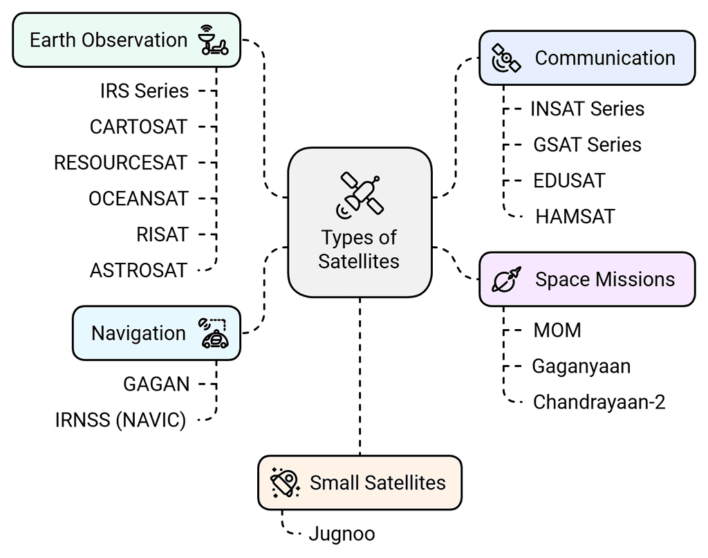
- Geostationary Satellites (Communication): INSAT Series, GSAT series, EDUSAT and HAMSAT
- Earth Observation Satellites: IRS series, CARTOSAT, RESOURCESAT, OCEANSAT and RISAT and recently envisioned ASTROSAT (Astronomy related)
- Navigation Satellites: GAGAN and IRNSS (now NAVIC)
- Space Missions: MOM, Gaganyaan and Chandrayaan-2
- Small Satellites: Jugnoo (Nanosatellite)
Astronomical Satellites
These satellites are used for the observation of distant stars and other objects in space. India’s ASTROSAT is an Astronomical satellite.
Astronomical satellites are those which are used for the observation of distant planets, galaxies, and other outer space objects. Astronomical performance from the Earth’s surface is limited by Earth’s atmospheric conditions. It makes it, even more, worse by the filtering and distortion of electromagnetic radiation. This makes it desirable to place astronomical observation devices into space.
But space-based astronomy is even more important for frequency ranges that are outside the optic and radio window. For example, X-ray astronomy is nearly impossible when done from the Earth, and has reached its current important stand within astronomy only due to orbiting satellites with X-ray telescopes. Infrared and ultraviolet are also greatly blocked.

The most famous astronomical satellite is the Hubble Telescope. Although now reaching the end of its life it has enabled scientists to see many things that would otherwise not have been possible. Nevertheless, it did suffer some major design setbacks that were only discovered once it was in orbit.
ASTROSAT observes the universe in the optical, ultraviolet, low, and high energy X-ray regions of the electromagnetic spectrum, whereas most other scientific satellites are capable of observing a narrow range of wavelength bands.
The scientific objectives of ASTROSAT mission are:
- To understand high energy processes in binary star systems containing neutron stars and black holes
- Estimate magnetic fields of neutron stars
- Study star birth regions and high energy processes in star systems lying beyond our galaxy
- Detect new briefly bright X-ray sources in the sky
- Perform a limited deep field survey of the Universe in the Ultraviolet region.
Communication Satellites
These satellites possibly form the greatest number of satellites that are in orbit. They are used for communicating over large distances. INSAT and GSAT of India come under this.
The Indian National Satellite (INSAT) systems which are placed in Geo-stationary orbits are one of the largest domestic communication satellite systems in the Asia-Pacific region. Established in 1983 with the commissioning of INSAT-1B, it initiated a major revolution in India’s communications sector and sustained the same later.
The height of the satellite above the Earth enables the satellites to communicate over vast distances and thereby overcoming the curvature of the Earth’s surface. Even within the communications field, there are a number of sub-categories.

Some satellites are used for point-to-point telecommunications links, others are used for mobile communications, and there are those used for direct broadcast. There are even some satellites used for mobile phone style communications.
Even though these satellites did not take the market in the way that was originally expected because terrestrial mobile phone networks spread faster than was originally envisaged, some mobile phone satellite systems still exist.
GSAT-19
GSAT-19 satellite with a lift-off mass of 3136 kg, is the communication satellite of India, configured around the ISRO’s standard I-3K bus.
- GSAT-19 carries Ka/Ku-band high throughput communication transponders.
- Besides, it carries a Geostationary Radiation Spectrometer (GRASP) payload to monitor and study the nature of charged particles and the influence of space radiation on satellites and their electronic components.
- GSAT-19 also features certain advanced spacecraft technologies including miniaturized heat pipe, fiber optic gyro, Micro-Electro-Mechanical Systems (MEMS) accelerometer, Ku-band TTC transponder, as well an indigenous Lithium-ion Battery.
- GSAT-19 satellite was launched by GSLV Mk III-D1 from the Second Launch Pad (SLP) at Satish Dhawan Space Centre SHAR (SDSC SHAR), Sriharikota.
GSAT-6A
GSAT-6A, similar to GSAT-6 is a high power S-band communication satellite configured around the I-2K bus.
- The mission life of the spacecraft planned is about 10 years.
- The satellite will also provide a platform for developing technologies such as the demonstration of 6 m S-Band Unfurlable Antenna, handheld ground terminals, and network management techniques that could be useful in satellite-based mobile communication applications.
- GSAT-6A was launched by GSLV-F08, March 29, 2018.
GSAT-31
GSAT-31- India’s telecommunication satellite, GSAT-31 was successfully launched in February 2019 from Kourou launch base, French Guiana by Ariane-5 VA-247.
This satellite will augment the Ku-band transponder capacity in Geostationary Orbit.

Earth Observation Satellites
These satellites are used for observing the earth’s surface and as a result, they are often termed geographical satellites. India’s IRS and RESOURCESAT are part of this.
- Indian Remote Sensing (IRS) satellite system was commissioned with the launch of IRS-1A, in 1988. With eleven satellites in operation, IRS is the largest civilian remote sensing satellite constellation in the world providing imageries in a variety of spatial resolutions, spectral bands, and swaths.
- The data is used for several applications covering agriculture, water resources, urban development, mineral prospecting, environment, forestry, drought, and flood forecasting, ocean resources, and disaster management.
- Using these satellites it is possible to see many features that are not obvious from the earth’s surface, or even at the altitudes at which aircraft fly. Using these earth observation satellites many geographical features have become obvious and they have even been used in mineral search and exploitation.
Cartosat-2 Series Satellite is the primary satellite carried by PSLV-C40.
- This remote sensing satellite is similar in configuration to earlier satellites in the series and is intended to augment data services to the users.
- The imagery sent by satellite will be useful for cartographic applications, urban and rural applications, coastal land use and regulation, utility management like road network monitoring, water distribution, creation of land use maps, change detection to bring out geographical and manmade features, and various other Land Information System (LIS) as well as Geographical Information System (GIS) applications.
RESOURCESAT-2A is a Remote Sensing satellite intended for resource monitoring.
- RESOURCESAT-2A is a follow-on mission to RESOURCESAT-1 and RESOURCESAT-2, launched in 2003 and 2011 respectively.
- RESOURCESAT-2A is intended to continue the remote sensing data services to global users provided by RESOURCESAT-1 and RESOURCESAT-2
Hyper Spectral Imaging Satellite (HysIS)
HysIS, the primary satellite of the PSLV-C43 mission, weighing about 380 kg, is an earth observation satellite configured around ISRO’s Mini Satellite-2 (IMS-2) bus.
The primary goal of HysIS is to study the earth’s surface in the visible, near-infrared, and shortwave infrared regions of the electromagnetic spectrum.
The co-passengers of HysIS include 1 micro and 29 nanosatellites from eight different countries including one each from Australia, Canada, Columbia, Finland, Malaysia, Netherlands, Spain, and 23 from the US.
RISAT-2B is a radar imaging earth observation satellite developed by ISRO.


Navigation Satellites
In recent years satellites have been used for accurate navigation. The first system known as GPS (Global Positioning System) was set up by the USA and was primarily intended for use as a highly accurate military system. Since then it has been adopted by a huge number of commercial and private users including India.
India launched its own navigation satellite in the name of the IRNSS-Indian Regional Navigation Satellite System.
The Polar Satellite Launch Vehicle, in its thirty-fifth flight (PSLV-C33), launcheD IRNSS- 1G, the seventh satellite of the Indian Regional Navigation Satellite System (IRNSS) into a Sub-Geosynchronous Transfer Orbit (Sub-GTO).
In 2017 all rubidium atomic clocks onboard IRNSS-1A failed, rendering the satellite redundant. ISRO’s attempt to replace it with IRNSS-1H was unsuccessful when the PSLV-C39 mission failed to deploy the satellite on 31 August 2017.
There are plans to expand Navic system by increasing constellation size from 7 to 11.

IRNSS-NAVIC
IRNSS is an independent regional navigation satellite system being developed by India.
- It is designed to provide accurate position information service to users in India as well as the region extending up to 1500 km from its boundary, which is its primary service area.
- IRNSS will provide two types of services, namely, Standard Positioning Service (SPS) which is provided to all the users, and Restricted Service (RS), which is an encrypted service provided only to the authorized users.
- The IRNSS System is expected to provide a position accuracy of better than 20 m in the primary service area.
Components of IRNSS
IRNSS comprises of a space segment and a ground segment.
The IRNSS space segment consists of EIGHT satellites, with three satellites in geostationary orbit and five satellites in inclined geosynchronous orbit.
IRNSS ground segment is responsible for navigation parameter generation and transmission, satellite control, ranging and integrity monitoring, and timekeeping.
Applications of IRNSS
- Terrestrial, Aerial and Marine Navigation
- Disaster Management
- Vehicle tracking and fleet management
- Integration with mobile phones
- Precise Timing
- Mapping and Geodetic data capture
- Terrestrial navigation aid for hikers and travellers
- Visual and voice navigation for drivers
International dimensions of Navigation System
- The significance of IRNSS cannot be underplayed. Navigation systems, once used by the most powerful militaries around the world, are also being used by civilians through their smartphones.
- In addition, many militaries are using them for a wide range of applications. India’s ability to develop its own system without having to rely on any external source will go a long way in securing itself.
- The US-managed GPS became available for large-scale use a decade ago or so, although the importance of location precision technologies in the military arena with an emphasis on accumulating hard power has prompted many countries, particularly in Asia, to develop their own versions of GPS and other space-based navigation systems.
- Some of the proven and more popular systems include the Chinese Beidou, Russian Glonass, and Japanese Quazi-Zenith Satellite System (QZSS) that is making slow progress.
- The best known and currently the most widely used navigation satellite system is the U.S. Global Positioning System (GPS), which became operational two decades ago.
- Russia too offers global coverage with its Global Navigation Satellite System (GLONASS). Europe is establishing its own global system, Galileo. Although the full constellation will be ready only by 2019, it plans to begin some services with a reduced number of satellites by the end of next year.
- China’s Beidou satellite navigation system, which launched its first navigation satellite in 2000, plans to have full global coverage by 2020. China has already launched 16 satellites and four experimental ones onto space as part of the Beidou system.
- In spite of the sovereignty and territorial disputes, including recent flare-ups with several Southeast Asian countries, China has been successful in selling its system in many countries in the region.
- Among other countries, Thailand, Laos, and Brunei have already subscribed to the Beidou navigation system. Pakistan and Sri Lanka in South Asia have also opted for the Chinese navigation system.
- Russia’s GLONASS was a response to the US’ GPS, and the GLONASS is run by Russia’s space forces. It has a 24 satellite-constellation, with 21 in operation and 3 as back-ups. Placed at an altitude of 19,000 km, each of the satellites orbit the earth in 11 hours and 15 minutes.
- The satellites are positioned in a manner to allow at least five satellites to be in view at any given time. India entered into a pact with Russia on satellite navigation collaboration way back in 2005 although it took them another six years to sign an agreement for India to receive military signals from Russia.
- In fact, though there have been several agreements signed in this regard; the Russian government has been unwilling to part with “precision codes” (which provides data to navigate up to one meter).
- Given the growing importance of location data for a variety of purposes including in the civilian, disaster management, and military domain, India cannot be lagging behind.
- A decision by the ISRO to involve the Indian industry in developing communication satellites and PSLVs will lighten the burden on the ISRO while helping to refocus their attention on some big science projects and remote sensing satellites. This move will also step up the process of establishing a much-needed strategic industry around outer space.
- Security of the nation has become one of the inevitable concerns and dependence on USGPS or Russia’s GLONASS can be a national threat. Independency is a key to security and IRNSS will not only secure Indian Territory but also boost confidence among Indian neighbors.
GAGAN
- The Ministry of Civil Aviation has decided to implement an indigenous Satellite-Based Regional GPS Augmentation System also known as the Space-Based Augmentation System (SBAS) as part of the Satellite-Based Communications, Navigation and Surveillance (CNS)/Air Traffic Management (ATM) plan for civil aviation.
- The Indian SBAS system has been given the acronym GAGAN – GPS Aided GEO Augmented Navigation.
- A national plan for satellite navigation including the implementation of the Technology Demonstration System (TDS) over the Indian air space as a proof of concept has been prepared jointly by the Airports Authority of India (AAI) and ISRO.
- TDS was successfully completed during 2007 by installing eight Indian Reference Stations (INRESs) at eight Indian airports and linked to the Master Control Center (MCC) located near Bangalore.
- The next major milestone in GAGAN is the conduct of PSAT (Preliminary System Acceptance Testing) which has been successfully completed in Dec 2010.
- The first GAGAN navigation payload is slated on GSAT-8 which was launched on May 21, 2011. The second GAGAN payload was launched on GSAT-10 in the first quarter of 2012. The third GAGAN payload is planned on another GEO satellite.
- The Russian system is known as GLONASS and the European Union’s Galileo and Chinese Beidou are among others.
- Indian space agency ISRO will launch the GSAT-32 satellite to replace GSAT-6A which stopped communicating a few days after its launch.
Reconnaissance Satellites
A reconnaissance satellite or intelligence satellite (commonly, although unofficially, referred to as a spy satellite) is an Earth observation satellite or communications satellite deployed for military or intelligence applications.
These satellites are able to see objects on the ground and are accordingly used for military purposes. As such their performance and operation are kept secret and not publicized. DRONES are part of the reconnaissance system.
Weather Satellites
As the name implies these satellites are used to monitor the weather. They have helped considerably in the forecasting of the weather and have helped provide a much better understanding not only of the underlying phenomena but also in enabling predictions to be made.
India’s Kalpana-1 and INSAT-3A are part of this.
Experimental Satellites
ISRO has launched many small satellites mainly for experimental purposes. This experiment includes Remote Sensing, Atmospheric Studies, Payload Development, Orbit Controls, recovery technology, etc.

Microsat
- The term “microsatellite” or “microsat” is usually applied to the name of an artificial satellite with a wet mass between 10 and 100 kg.
- However, this is not an official convention and sometimes those terms can refer to satellites larger than that, or smaller.
- PSLV-C40 carries a Microsatellite (Microsat) built by ISRO as a co-passenger payload. Microsat is a small satellite in the 100 kg class that derives its heritage from the IMS-1 bus in the recent launch of the Cartosat-2 series.
Nanosatellites
- The term “nanosatellite” or “nanosat” is applied to an artificial satellite with a wet mass between 1 and 11 kg.
- PSLV-C37 carried two ISRO Nano Satellites – INS-1A and INS-1B as co-passenger satellites, which was launched on Feb 15, 2017. INS-1C was launched by PSLV-C40 on Jan 12, 2018, as a co-passenger satellite.
Academic Institute Satellites
ISRO has influenced educational institutions by its activities like making satellites for communication, remote sensing, and astronomy. The launch of Chandrayaan-1 increased the interest of universities and institutions towards making experimental student satellites. Capable Universities and institutions can venture into space technology on-orbit with guidance and support from ISRO byways of Development of Payload and Design & Fabrication of Satellite.

Orbits
There are several types of orbits:
- Polar Orbit
- Sun Synchronous Orbit
- Geosynchronous Orbit
- Geostationary Orbit

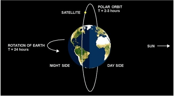
Polar Orbit
- The more correct term would be near-polar orbits. These orbits have an inclination near 90 degrees.
- This allows the satellite to see virtually every part of the Earth as the Earth rotates underneath it.
- A satellite in a polar orbit will pass over the equator at a different longitude on each of its orbits
- It takes approximately 90 minutes for the satellite to complete one orbit.
- These satellites have many uses.
- As measuring ozone concentrations in the stratosphere or measuring temperatures in the atmosphere.
- Earth Mapping and Observation
- Reconnaissance
- Weather satellites
Sun Synchronous Orbit
- These orbits allow a satellite to pass over a section of the Earth at the same time of day. Since there are 365 days in a year and 360 degrees in a circle, it means that the satellite has to shift its orbit by approximately one degree per day.
- These satellites orbit at an altitude between 700 to 800 km. These satellites use the fact since the Earth is not perfectly round (the Earth bulges in the center), the bulge near the equator will cause additional gravitational forces to act on the satellite. This causes the satellite’s orbit to either proceed or recede.
- These orbits are used for satellites that need a constant amount of sunlight. Satellites that take pictures of the Earth would work best with bright sunlight, while satellites that measure longwave radiation would work best in complete darkness.
- These satellites are very important for military and remote sensing purposes.

Geosynchronous Orbit
- A geosynchronous orbit is a geocentric orbit that has the same orbital period as the sidereal rotation period of the Earth.
- Geosynchronous orbits allow the satellite to observe almost a full hemisphere of the Earth. These satellites are used to study large-scale phenomena such as hurricanes, or cyclones.
- Geosynchronous orbit is a repeating path in which the satellite is always in the same area of the sky in respect to the rotating Earth.
- These orbits are also used for communication satellites. The disadvantage of this type of orbit is that since these satellites are very far away, they have poor resolution. The other disadvantage is that these satellites have trouble monitoring activities near the poles.
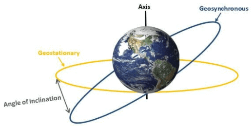
Geostationary Orbit
If we need a satellite for the purpose which needs this satellites to remain at a particular distance from earth at all the time, then we need circular orbits so all the points on circular orbit are at equal distance from earth’s surface. The circular equatorial orbit is exactly in the plane of equator on the earth. If the satellite is moving in the circular-equatorial orbit and its angular velocity is equal to earth’s angular velocity, the satellite is said to be moving along with the earth. This satellite would appear stationary from the earth and this orbit would be called Geostationary Orbit.
Features of geostationary satellite
- The orbit is circular
- The orbit is in an equatorial plane i.e. directly above the equator and thus inclination is zero.
- The angular velocity of the satellite is equal to the angular velocity of the earth
- The period of revolution is equal to the period of rotation of the earth.
- Finish one revolution around the earth in exactly one day i.e. 23 hours, 56 minutes, and 4.1 seconds
- There is Only one geostationary orbit.

Difference between Geostationary and Geosynchronous Satellites
In geostationary, the orbit is circular and in equatorial plane thus the inclination is zero. So there is only one geostationary orbit. Also, the angular velocities of these satellites are equal to angular velocity of the earth and hence these appear to be stationary with respect to earth all the time.
On the other hand, in geosynchronous satellites, the orbit is neither circular nor equatorial and hence is inclined. It also has angular velocity equals to earths and period of revolution equals to rotation of earth as geostationary satellites. But there are many geosynchronous orbits unlike only one geostationary orbit.
Low Earth Orbit (LEO)
With Low Earth Orbit extending from 200 km to 1200 km, it means that it is relatively low in altitude, although well above anything that a conventional aircraft can reach. However, LEO is still very close to the Earth, especially when compared to other forms of satellite orbit including geostationary orbit.
LEO characteristics
- Orbit times are much less than for many other forms of orbit.
- Less energy is expended placing the satellites in LEO than higher orbits.
- The lower orbit means the satellite and user are closer together and therefore path losses less than for other orbits such as GEO.
- LEO satellites have shorter life spans than others
- Some speed reduction may be experienced as a result of friction from the low, but measurable levels of gasses, especially at lower altitudes.
- Radiation levels are lower than experienced at higher altitudes.
Applications for LEO satellites
- A variety of different types of satellites use the LEO orbit levels. These include different types and applications including:
- Communications satellites – some communications satellites including the Iridium phone system using LEO.
- Earth monitoring satellites use LEO as they are able to see the surface of the Earth more clearly as they are not so far away. They are also able to traverse the surface of the Earth.
- The International Space Station is in an LEO that varies between 320 km (199 miles) and 400 km (249 miles) above the Earth’s surface.
Space debris in LEO
- Apart from the general congestion experienced in Low Earth Orbit, the situation is made much worse by the general level of space debris that exists.
- There is a real and growing risk of collision and major damage – any collisions themselves are likely to create further space debris.
Medium Earth Orbits (MEO)
- They are in between LEO and GEO orbits. Operate about 8000-20000km above the earth that is lower than GEO and higher than LEO.
- Basically used for communication satellites
- They are placed in an elliptical orbit.
- Examples include GPS and Global Communication and Orblink.
Two medium Earth orbits are notable: the semi-synchronous orbit and the Molniya orbit.
- Semi-synchronous orbit is a near-circular orbit (low eccentricity) 26,560 kilometers from the center of the Earth (about 20,200 kilometers above the surface).
(i) A satellite at this height takes 12 hours to complete an orbit.
(ii) In 24-hours, the satellite crosses over the same two spots on the equator every day. This orbit is consistent and highly predictable.
(iii) It is the orbit used by the Global Positioning System (GPS) satellites. - Molniya orbit is the second common medium Earth orbit.
(i) It was invented by the Russians, the Molniya orbit works well for observing high latitudes.
(ii) Molniya orbit offers a useful alternative to geostationary orbit, as satellites in a geostationary orbit are parked over the equator, so they don’t work well for far northern or southern locations, which are always on the edge of view of geostationary satellites.
(iii) The Molniya orbit combines high inclination (63.4°) with high eccentricity (0.722) to maximize viewing time over high latitudes.
(iv) Each orbit lasts 12 hours, so the slow, high-altitude portion of the orbit repeats over the same location every day and night. Russian communications satellites and the Sirius radio satellites currently use this type of orbit.
 Molniya Orbit
High Earth Orbit
- High Earth Orbit is when a satellite reaches exactly 42,164 kilometers from the center of the Earth (about 36,000 kilometers from Earth’s surface).
- At this altitude, the satellite enters a sort of “sweet spot” in which its orbit matches Earth’s rotation. This special, high Earth orbit is called geosynchronous.
(i) A satellite in a circular geosynchronous orbit directly over the equator (eccentricity and inclination at zero) will have a geostationary orbit that does not move at all relative to the ground.
(ii) This is because the satellite orbits at the same speed that the Earth is turning, it is always directly over the same place on the Earth’s surface. - The use of a geostationary orbit is extremely valuable for weather monitoring and communication (phones, television, radio) because satellites in this orbit provide a constant view of the same surface.
- Finally, many high Earth-orbiting satellites monitor solar activity, track magnetic and radiation levels in space around them.
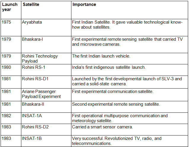
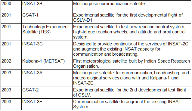
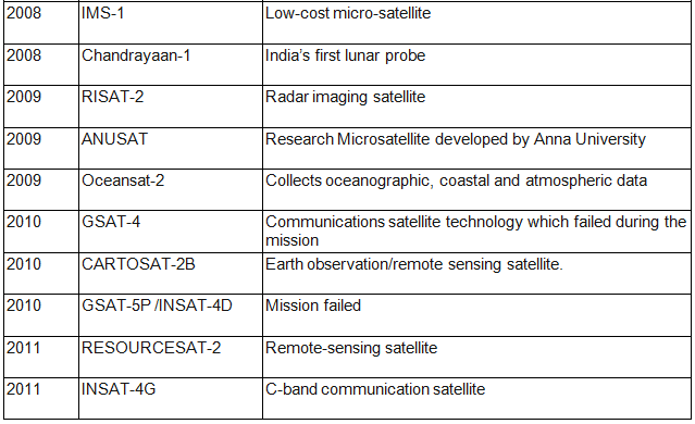
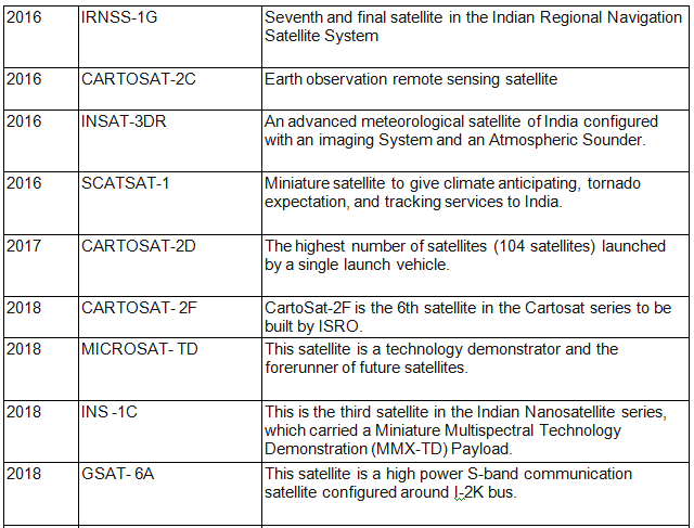
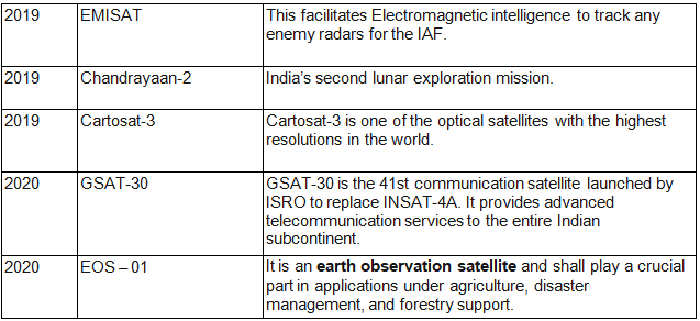
List of Indian Satellites – (1975 – 2020)
India has been successfully launching satellites of various types since 1975. The Indian Space Research Organization (ISRO) is considered as the Sole Space agency of India and was formed in 1969. The Headquarters of ISRO is in Bangalore.
The table below gives us a list of various satellites of India that were launched between 1975-2020:


|
146 videos|358 docs|249 tests
|
FAQs on Space research in India - Science & Technology for UPSC CSE
| 1. What are the major achievements of space research in India? |  |
| 2. How does the Indian Space Research Organisation (ISRO) contribute to global space research? | |
| 3. What are the future plans of India in the field of space exploration? | |
| 4. How does space technology benefit everyday life in India? | |
| 5. What is the significance of India's Mars Orbiter Mission? | |

|
10.5K Views |

|
4.90/5 Rating |

|
Dec 22, 2024 Last updated |
|
146 videos|358 docs|249 tests
|

|
Explore Courses for UPSC exam
|
|
Exam
,past year papers
,practice quizzes
,Space research in India | Science & Technology for UPSC CSE
,Space research in India | Science & Technology for UPSC CSE
,Summary
,MCQs
,Free
,ppt
,Previous Year Questions with Solutions
,study material
,Viva Questions
,Space research in India | Science & Technology for UPSC CSE
,Extra Questions
,Objective type Questions
,Semester Notes
,Important questions
,mock tests for examination
,video lectures
,shortcuts and tricks
,Sample Paper
;


Space research in India Free PDF Download
Importance of Space research in India
Space research in India Notes
Space research in India UPSC Questions
Study Space research in India on the App
|
© EduRev
|
Education Revolution
|


|


