Geosynclines | Geography Optional for UPSC PDF Download
Introduction to Geosynclines
Geosynclines refer to expansive, elongated areas of shallow water bodies that are surrounded by more stable landmasses. These areas receive massive deposits of sediment from their surrounding regions. They are typically characterized as long, narrow ocean basins that have experienced continuous sediment deposition and subsidence over extended periods.
These sediment deposits within geosynclines eventually become uplifted and folded, leading to the formation of folded mountain ranges. As a result, it is often said that such mountains originate from geosynclines. Examples of geosynclines in geological history include the Tethys Sea in Asia, the Appalachian geosynclines in North America, and the Caledonian geosynclines in Great Britain.
Concept of Geosyncline Theory and Its Development
The concept of geosynclines was first introduced by James Hall and James Dwight Dana and later expanded upon by Émile Haug. Hall's research on the stratigraphy and structure of the northern Appalachians led him to discover that folded Paleozoic sediments in mountain ranges were shallow-water marine types, with a thickness of 12 kilometers. This thickness was ten to twenty times greater compared to unfolded rock strata of corresponding ages found in the interior lowlands to the west.
- Hall's findings suggested that the deposition of massive sequences of shale, sandstone, and limestone indicated that the underlying floor of older rocks had subsided by a similar amount. Mountain formation was preceded by extended periods of down-warping, during which sediment accumulation balanced the subsidence of the crust. Dana (1873) termed such troughs as "geosynclinal troughs," which later became known as "geosynclines."
- H. Stille developed an important classification of geosynclines, dividing the earth's crust into two primary divisions: Cratons and Ortho-geosynclines. Cratons are further divided into hochkraton (stable continental crust) and fiefkraton (stable oceanic crust). Ortho-geosynclines are subdivided into miogeosynclines and eugeosynclines, with eugeosynclines characterized by intermittent volcanic activity during sedimentation and miogeosynclines having low volcanic activity.
- E. Haug defined geosynclines as deepwater regions with considerable length but relatively narrow width. He created paleogeographical maps of the world to demonstrate that present-day fold mountains originated from the massive geosynclines of the past. Haug identified five major landmasses from the Mesozoic Era and four geosynclines located between these rigid masses.
- According to Haug, the transgressional and regressional phases of seas directly impact the littoral margins of geosynclines. Evans further explained that geosynclines could be found between two landmasses, in front of a mountain or plateau, along continental margins, or in front of a river mouth.
Geosynclinal Orogen Theory of Kober
- The renowned German geologist Kober provided a comprehensive and systematic analysis of the Earth's surface features in his book, 'Der Bau der Erde.' His primary goal was to establish a connection between ancient, rigid landmasses or tablelands and more mobile areas or geosynclines, which he referred to as orogen.
- Kober aimed to explain not only the origins of mountains using his geosynclinal theory but also to delve into various aspects of mountain formation, such as their creation, geological history, evolution, and development. He viewed the old, rigid landmasses as the foundational building blocks for today's continents, asserting that modern continents have evolved from these rigid structures. He described the process of mountain building, or orogenesis, as the mechanism connecting rigid landmasses with geosynclines. In other words, mountains are created from geosynclines as a result of the influence of rigid landmasses.
- Kober's geosynclinal theory is founded on the idea that the Earth's contraction forces, caused by cooling, play a significant role in its history. As J.A. Steers stated in 1932, "Kober is definitely a constructionist, with contraction providing the motive force for the compressive stress." This means that the contraction forces generated by the Earth's cooling lead to horizontal movements of rigid landmasses or forelands, which in turn compress, buckle, and fold sediments to form mountain ranges.
Base of the Geosynclinal Orogen Theory
Kober proposed that in the past, there were mobile water zones in locations where mountains currently exist. He referred to these mobile water zones as geosynclines or orogens, which are areas where mountain formation occurs. Kober also identified rigid land masses surrounding these geosynclines, which he called kratogens.
Some examples of these old rigid masses include the Canadian Shield, Baltic Shield or Russian Massif, Siberian Shield, Chinese Massif, Peninsular India, African Shield, Brazilian Mass, and the rigid masses of Australia and Antarctica. Kober also suggested that the mid-Pacific geosyncline separated northern and southern landmasses, which later sank to form the Pacific Ocean.
During the Mesozoic era, Kober identified eight distinct morphotectonic units based on the earth's surface features. These units include:
- Africa, along with parts of the Atlantic and Indian Oceans
- The combined landmass of India and Australia
- Eurasia
- North Pacific continents
- South Pacific continents
- South America and Antarctica
Kober recognized six major periods of mountain formation throughout Earth's history. Three of these periods occurred during the pre-Cambrian period, though little is known about them. The Palaeozoic era saw two significant mountain-building periods: the Caledonian orogenesis, which ended during the Silurian period, and the Variscan orogeny, which culminated in the Permo-Carboniferous period. The final (6th) mountain-building event, the Alpine orogeny, was completed during the Tertiary epoch.
Kober believed that mountains were formed from geosynclines. He described geosynclines as long, wide water areas characterized by sedimentation and subsidence, which are the locations where mountain formation (or orogenesis) occurs. J.A. Steers (1932) stated that Kober's ideas combined the older geosynclinal hypothesis by Hall and Dana (later developed by Haug) with his own views on orogenesis.
Phases of the Mountain Building
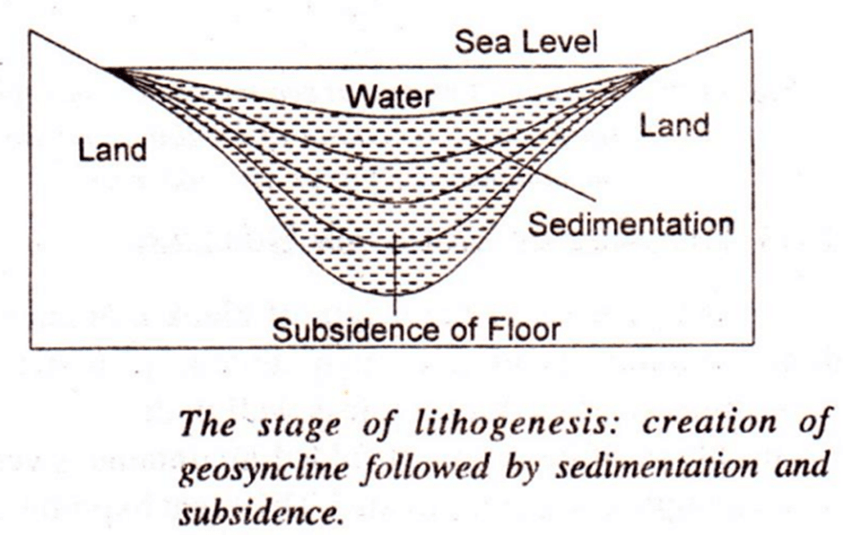
There are three different stages or phases of the mountain-building process.- Lithogenesis: Lithogenesis is the initial stage of mountain formation, characterized by the creation, sedimentation, and subsidence of geosynclines. Geosynclines form as a result of the Earth's cooling process, which leads to contraction. The surrounding stable areas, or forelands, experience erosion, causing rocks and boulders to wear away and be deposited into the geosynclines. As more sediment accumulates, the geosynclines continue to subside, leading to an increased thickness of sediments.
 Lithogenesis
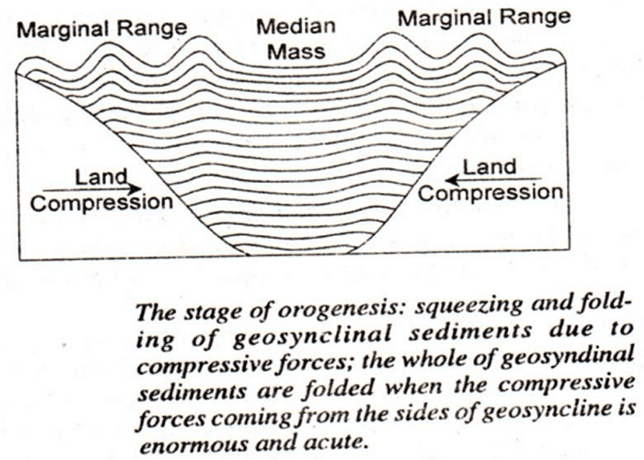
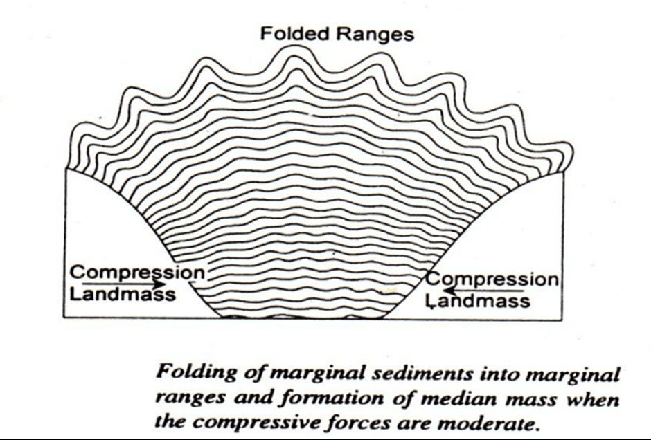
- Orogenesis: Orogenesis is the stage in which the sediments in the geosynclines are compressed and folded, forming mountain ranges. This occurs due to the convergence of forelands towards each other, which is caused by the Earth's contraction. The immense pressure generated by the moving forelands results in the contraction, squeezing, and folding of the sediments that have accumulated in the geosynclines.
 Orogenesis
 - Gliptogenesis: The final stage of mountain building, gliptogenesis, involves the gradual rise of mountain ranges and the ongoing erosion processes by natural agents, such as wind, water, and ice. This stage highlights the continuous evolution of the mountains as they are subjected to various geological processes.
 Gliptogenesis
Types of Geosynclines
There are seven types of geosynclines as follows:Geosynclines are elongated depressions in the Earth's crust that accumulate large amounts of sediments and volcanic rocks. These basins eventually undergo deformation, leading to the formation of fold-mountain chains. There are seven types of geosynclines, each with unique features and formation processes:
- Ortho-geosynclines: These are elongated basins that fill up with a significant thickness of sediments before undergoing deformation, resulting in the formation of a fold-mountain chain.
- Eugeosynclines: These geosynclines contain large amounts of sediments and volcanic rocks and are typically situated away from shield areas or stable regions of the Earth's crust, known as Kratons.
- Miogeosynclines: Forming adjacent to Kratons, these geosynclines have a thinner layer of sediments and lack volcanic rocks.
- Taphrogeosynclines: These elongated depressions result from faulting in the Earth's crust and are also called 'graben' or 'rift-valleys.'
- Parageosynclines: These geosynclines are located within the Kraton itself.
- Zeugo-geosynclines: These are parageosynclines that have marginal uplifts, or areas of the crust that have risen relative to their surroundings.
- Auto-geosynclines: Unlike zeugo-geosynclines, these are parageosynclines that do not have marginal uplifts.
Most mountain-building events, or orogenies, occur at the sites of geosynclines. The resulting mountains typically consist of sediments and volcanic rocks that have been deformed and metamorphosed to varying extents, depending on their position and depth within the orogenic belt.
The Modern Concept of Geosyncline
The concept of geosynclines has evolved significantly with the introduction of Plate Tectonic Theory. Active margins refer to continental margins situated along plate boundaries where subduction, collision, or transform fault motion occurs. Passive margins, on the other hand, are continental margins that move away from a spreading axis.- An example of a passive margin can be found on the east coast of North America, where sediment deposits accumulate as the continent moves away from the spreading axis. As the lithosphere cools and becomes denser, the ocean floor deepens off the passive margin, and sediments continue to be deposited. This thick sediment accumulation along the border of a passive margin is called a geosyncline.
- Research conducted during the latter half of the 20th century has shown that a geosyncline is a thick, rapidly accumulating body parallel to the continent. The traditional idea of a geosyncline as an intra-cratonic trough bordered by mountains providing sediments is no longer considered accurate. Instead, sediment accumulation can occur on the continental shelf and slope or in a trough or trench.
- The term "geocline" is now used because the structure of a geosyncline is not a two-sided trough, but rather, it is more open towards the ocean. Geoclines of passive continental margins can be classified into two types: miogeoclines, which are wedges of shallow-water sediments of marine origin that make up the continental shelves; and eugeoclines, which are wedges of deep-sea sediment deposited at the base of the continental slope and located on oceanic crust. Both types of geoclines are formed by the accumulation of sediments as the lithosphere slowly subsides.
- In the Gulf of Mexico, miogeocline sediments can reach a thickness of 20 km at the outer edge of the continental shelf. Eugeocline sediments can be found on the oceanic crust above an oceanic volcano. The continuous accumulation of sediments in miogeoclines for about 200 million years has been enabled by the sinking of the crust due to sediment loading. Miogeocline areas are economically significant due to the presence of mineral oil.
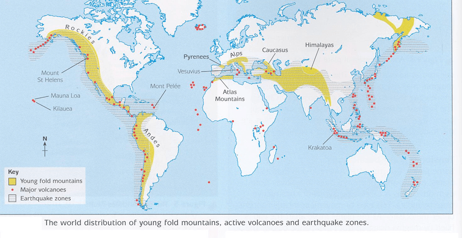
 Fold mountain locations
Conclusion
Geosynclines are elongated depressions in the Earth's crust that accumulate large amounts of sediments and volcanic rocks, eventually leading to the formation of fold-mountain chains. The concept of geosynclines has evolved over time, with the introduction of Plate Tectonic Theory further refining our understanding of their formation and classification. Geoclines, which include miogeoclines and eugeoclines, are now understood as thick sediment accumulations along passive continental margins that play a significant role in the geological history of the Earth and the formation of mountain ranges.Frequently Asked Questions (FAQs) of Geosynclines
What is a geosyncline?
A geosyncline is an expansive, elongated area of shallow water bodies that receive massive deposits of sediment from their surrounding regions. They are characterized as long, narrow ocean basins that have experienced continuous sediment deposition and subsidence over extended periods.
How do geosynclines contribute to the formation of mountain ranges?
Sediment deposits within geosynclines eventually become uplifted and folded, leading to the formation of folded mountain ranges. As a result, it is often said that such mountains originate from geosynclines.
Who first introduced the concept of geosynclines?
The concept of geosynclines was first introduced by James Hall and James Dwight Dana, and later expanded upon by Émile Haug.
What are the three stages of the mountain-building process?
The three stages of the mountain-building process are lithogenesis (creation, sedimentation, and subsidence of geosynclines), orogenesis (compression and folding of sediments in geosynclines, forming mountain ranges), and gliptogenesis (gradual rise of mountain ranges and ongoing erosion processes).
How has the concept of geosynclines evolved with the introduction of Plate Tectonic Theory?
The concept of geosynclines has evolved significantly with the introduction of Plate Tectonic Theory, which has led to the understanding of active and passive continental margins. This has changed the view of geosynclines as intra-cratonic troughs bordered by mountains providing sediments to a more open structure, with thick sediment accumulation occurring on the continental shelf and slope or in a trough or trench.
|
303 videos|636 docs|252 tests
|
FAQs on Geosynclines - Geography Optional for UPSC
| 1. What is a geosyncline? |  |
| 2. What is the geosyncline theory and how did it develop? |  |
| 3. What are the phases of mountain building in geosynclines? |  |
| 4. What are the types of geosynclines? |  |
| 5. What is the modern concept of geosyncline? |  |


