Temperature & Salinity of the Oceans | Geography Optional for UPSC PDF Download
Vertical & Horizontal Temperature Distribution of Oceans
Oceans play a significant role in regulating the Earth's temperature by absorbing over 80% of the solar radiation that reaches our planet. Water has an exceptional ability to absorb heat, with the top 10% of the oceans containing more heat than the entire atmosphere. However, ocean temperatures are not consistent throughout and can vary due to several factors.These factors include:
- Latitude: Ocean surface temperature decreases as one moves from the equator towards the poles. This is because the Sun's rays are vertical at the equator and become slanted as they reach the poles.
- Prevailing Winds: The direction of prevailing winds, such as Trade Winds and Westerlies, can determine the surface temperature of ocean waters. For example, the eastern edges of the ocean along the trade wind belt have cooler waters due to the warm waters being pushed away from the coast, causing upwelling of cold bottom waters.
- Unequal distribution of Land and Water: The Northern Hemisphere has more land area than the Southern Hemisphere, resulting in warmer Northern Oceans compared to the Southern Oceans.
- Evaporation Rate: The rate of evaporation varies across different latitudes, with warmer tropical ocean waters having higher evaporation rates than cooler temperate ocean waters.
- Water density: The density of ocean water is primarily influenced by its temperature and salinity, which also varies across latitudes. High salinity areas have ocean waters with relatively higher temperatures and vice versa.
- Ocean Currents: Surface temperatures of oceans are affected by cold and warm currents. Warm water increases temperature and evaporation rates, leading to more rainfall, while cold currents decrease temperature, resulting in more fog but less precipitation.
- Local Factors: Various local factors such as submarine ridges, weather conditions (storms, cyclones, winds, fogs, cloudiness), evaporation rates, and precipitation can also impact ocean temperature distribution.
Understanding ocean temperatures is crucial for determining the movement of vast water volumes (ocean currents), the distribution of marine organisms at different ocean depths, and the climate of coastal lands. The primary source of heat in oceans is the Sun, which provides solar energy (insolation). The Earth's interior also provides heat to the ocean, though this contribution is minimal compared to the Sun's input.
Vertical Distribution of Temperature
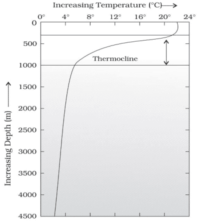
The distribution of temperature in the ocean varies with depth, as both sunlight and energy decrease as one goes deeper. At the ocean surface, only about 45% of light energy penetrates to a depth of one meter, and just 16% reaches 10 meters deep. Based on temperature differences, the ocean can be divided into three main zones:- Surface Zone or Mixed Zone: Also known as the Photic or Euphoric zone, this is the top layer of the ocean where temperature and salinity remain relatively consistent. It makes up approximately 2% of the ocean's total water volume and extends to a depth of around 100 meters.
- Thermocline: Located between 100 and 1000 meters deep, this zone contains about 18% of the ocean's total water volume. In the thermocline, there is a sharp decline in temperature as the water density increases with depth.
- Deep Zone: Found below 1000 meters in mid-latitude regions, this zone comprises roughly 80% of the ocean's total water volume. The temperature in the deep zone remains constant, with the ocean floor having a temperature only one or two degrees Celsius above the freezing point.
Thermocline
- A thermocline is a transitional layer in the ocean that separates the warmer surface water from the colder deep water.
- This boundary region is typically found at a depth of 100 to 400 meters below the sea surface and extends downward for several hundred meters.
- Within the thermocline, there is a rapid decrease in temperature, and approximately 90% of the ocean's total water volume is located below this layer in the deep ocean.
- In this deep ocean zone, temperatures can reach close to 0°C.
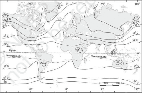
- The temperature distribution of ocean waters varies across different latitudes, with surface water temperatures generally being higher in the lower latitudes and decreasing towards the poles. In the lower latitudes, surface water temperatures are typically around 26 degrees Celsius.
- In the Northern Hemisphere, the average ocean temperature is 19.4 degrees Celsius. However, this average temperature varies depending on the latitude, with 22 degrees Celsius recorded at 20 degrees latitude, and 14 degrees Celsius recorded at 40 degrees latitude. Near the poles, the temperature drops to 0 degrees Celsius.
- Throughout the year, ocean water temperatures in the Northern Hemisphere fluctuate, with the maximum and minimum temperatures usually occurring in August and February, respectively. The average annual temperature range is about 12 degrees Celsius.
- The North Atlantic Ocean experiences the highest annual temperature range, and inland seas generally have a higher temperature range compared to open oceans. Overall, the horizontal distribution of ocean temperatures is influenced by factors such as latitude, seasonal changes, and the location of different bodies of water.
Salinity of Ocean Water
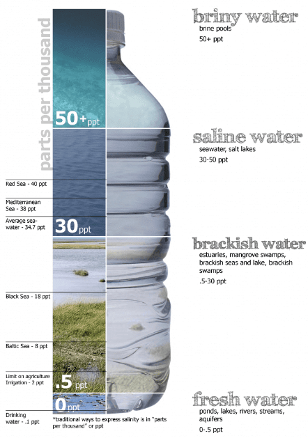
- Ocean salinity refers to the total amount of dissolved salts present in seawater. It is measured by calculating the quantity of salt present in 1,000 grams of seawater and is typically expressed in 'parts per thousand' (ppt). A salinity level of 24.7% is considered the maximum threshold for classifying water as 'brackish.'
- Salinity plays a crucial role in determining various chemical characteristics of natural water bodies and influencing biological processes. On maps, isohalines are used to depict the salinity levels of different locations. These lines connect places with equal salinity levels.
- On average, the salinity of the ocean is around 3.5% or 35 parts of salt per 1,000 parts of water.
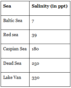
The salinity of the Great Salt Lake, (Utah, USA), the Dead Sea, and the Lake Van in Turkey are 220, 240, and 330 respectively. The oceans and salt lakes are becoming saltier as time goes on because the rivers dump more salt into them, while freshwater is lost due to evaporation.
Role of Ocean Salinity
- Salinity determines compressibility, thermal expansion, temperature, density, absorption of insolation, evaporation, and humidity.
- It also influences the composition and movement of the sea: water and the distribution of fish and other marine resources.
Share of different salts is as shown below—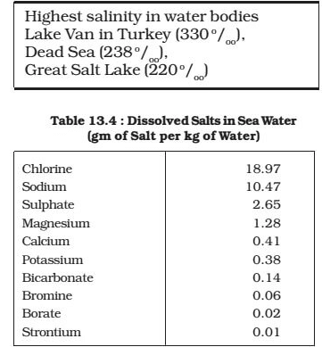
Most Saline Water Bodies
- sodium chloride — 77.7%
- magnesium chloride—10.9%
- magnesium sulphate —.4.7%
- calcium sulphate — 3.6%
- potassium sulphate — 2.5%
Factors Affecting Salinity of Ocean Water
- There are certain areas in the ocean where minimal rainfall occurs, but strong, warm, and dry winds lead to a high rate of evaporation. When water evaporates, the water vapor rises into the atmosphere, leaving the salt behind. This results in an increase in the salinity of the seawater, making it denser. The North and South Atlantic Oceans, for example, have high salinity levels due to the presence of powerful winds and limited rainfall.
- The Mediterranean Sea in Europe is another area with significantly high salinity levels, often exceeding 38 parts per thousand (ppt). This is mainly because the Mediterranean Sea is relatively isolated from the main ocean, and the rate of evaporation surpasses the amount of rainfall and freshwater input from rivers.
Rate of Evaporation
- Compare to the temperate latitude ocean, the ocean between 20°N and 30°N latitudes has higher salinity because of a higher rate of evaporation (because of high temperature).
- But this doesn’t mean that tropical oceans will have higher salinity because of the points mentioned in the next point.
The amount of freshwater added by precipitation, streams, and icebergs
- The salinity of a body of water is influenced by the amount of freshwater added through various sources, such as precipitation, streams, and icebergs. In regions with high daily rainfall, high relative humidity, and an influx of freshwater, the salinity tends to be lower.
- For example, ocean waters where large rivers like the Amazon, Congo, Ganges, Irrawaddy, and Mekong flow into have lower salinity levels due to the significant amount of freshwater they contribute. Additionally, the Baltic, Arctic, and Antarctic waters have salinity levels below 32 parts per thousand (ppt) because they receive a substantial amount of freshwater from melting icebergs and several large rivers that flow towards the poles.
The degree of water mixing by currents
- Regions that are land-locked (enclosed by lands) have higher salinity because of no mixing of freshwater + continuous evaporation. E.g. – Black Sea, Caspian Sea, red sea, Persian Gulf
- The range of salinity is negligible where there is free mixing of water by surface and subsurface currents.
Horizontal Distribution of Salinity
To make life easier, I will remove the symbol o/oo and place only the number.
- The salinity for normal open ocean ranges between 33 and 37.
High Salinity Regions
- In the landlocked Red Sea (don’t confuse this to the Dead Sea which has much greater salinity), it is as high as 41.
- In hot and dry regions, where evaporation is high, the salinity sometimes reaches 70.
Comparatively Low Salinity Regions
- In the estuaries (enclosed mouth of a river where fresh and saline water get mixed) and the Arctic, the salinity fluctuates from 0 – 35, seasonally (freshwater coming from ice caps).
Pacific
- The salinity variation in the Pacific Ocean is mainly due to its shape and larger areal extent.
Atlantic
- The Atlantic Ocean has an average salinity level ranging from 36 to 37.
- In the equatorial region, the salinity is approximately 35, due to the heavy rainfall, high humidity, cloudiness, and the calm air of the doldrums near the equator.
- On the other hand, the polar regions have lower salinity levels, between 20 and 32, as they experience minimal evaporation and receive a large amount of freshwater from melting ice.
- The highest salinity level, 37, can be found between 20° N and 30° N latitude and 20° W and 60° W longitude, with a gradual decrease as one moves northward.
Indian Ocean
- The Indian Ocean has an average salinity level of 35. In the Bay of Bengal, a lower salinity level can be observed, primarily because of the freshwater influx from the Ganges River.
- In contrast, the Arabian Sea experiences higher salinity levels as a result of increased evaporation and a limited supply of fresh water.
Marginal seas
- The North Sea, despite being situated in higher latitudes, exhibits increased salinity as a result of the more saline water transported by the North Atlantic Drift. In contrast, the Baltic Sea has lower salinity levels due to the significant influx of freshwater from rivers.
- The Mediterranean Sea experiences higher salinity levels as a result of substantial evaporation. However, the Black Sea has exceptionally low salinity levels due to the immense inflow of freshwater from surrounding rivers.
Inland Seas and Lakes
- Inland seas and lakes have a high salinity level due to the constant influx of salt from rivers that flow into them. As water evaporates from these bodies of water, the salt concentration increases, making them progressively more saline over time.
- For example, the Great Salt Lake in Utah, USA, the Dead Sea, and Lake Van in Turkey have salinity levels of 220, 240, and 330, respectively.
- The salinity of oceans and salt lakes continues to rise as rivers deposit more salt into them and freshwater evaporates.
Cold and Warm Qater Mixing Zones
- Salinity decreases from 35 – 31 in the western parts of the northern hemisphere because of the influx of melted water from the Arctic region.
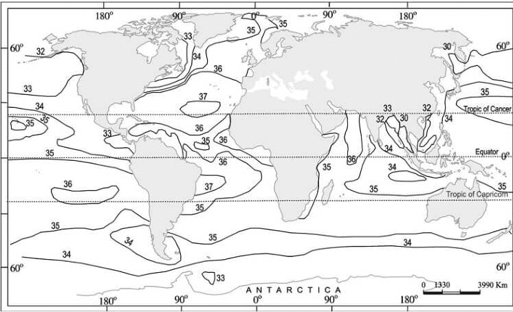 Surface Salinity of World Oceans
Sub-Surface Salinity
- With depth, the salinity also varies, but this variation again is subject to latitudinal difference. The decrease is also influenced by cold and warm currents.
- In high latitudes, salinity increases with depth. In the middle latitudes, it increases up to 35 metres and then it decreases. At the equator, surface salinity is lower.
Vertical Distribution of Salinity
- The distribution of salinity in the ocean varies with depth, and this variation is influenced by the sea's location. Surface salinity can increase due to water loss from ice formation or evaporation, or it can decrease when freshwater, such as river water, enters the sea.
- However, salinity at deeper levels remains relatively constant, as there is no mechanism for water loss or salt addition at these depths.
- Consequently, a noticeable difference in salinity exists between the surface and deep ocean zones.
- Lower salinity water typically floats above denser, higher salinity water. In general, salinity increases as depth increases, and there is a specific zone known as the halocline where the salinity changes sharply. When other factors are held constant, an increase in seawater salinity causes the water's density to rise. As a result, high salinity water tends to sink below lower salinity water, leading to stratification based on salinity levels.
Salt Budget
The salt budget, also known as the salt cycle, is a process that encompasses the movement of salt from the ocean to the lithosphere, and to a lesser extent, the atmosphere, before eventually returning to the ocean. This cycle operates over an extended period of time.
- As water moves across the Earth's surface, it erodes minerals from rocks and carries them into rivers and streams. This mineral-rich water then flows into the ocean, contributing to its salinity levels. Over time, some of these salts accumulate on the ocean floor through sedimentation, eventually turning into mineralized rocks.
- Over millions of years, geological processes such as plate tectonics and volcanic activity cause some of these rocks to rise above the ocean surface, returning the salt to the lithosphere in the form of minerals. Additionally, wind can carry small amounts of salt from the ocean into the atmosphere, where it can later return to land through precipitation. However, this atmospheric transfer represents a relatively minor portion of the overall salt movement between land and sea.
- In summary, the salt budget is a long-term process that involves the movement of salt from the ocean to the lithosphere and atmosphere, and ultimately back to the ocean. This cycle is primarily driven by the erosion of minerals from rocks and the geological processes that lift these minerals back to the Earth's surface.
Conclusion
The temperature and salinity distribution of oceans play a vital role in regulating the Earth's climate, supporting marine life, and influencing coastal environments. Both temperature and salinity vary vertically and horizontally across the ocean, with factors such as latitude, prevailing winds, ocean currents, and local conditions impacting their distribution. Understanding these variations is crucial for predicting climate changes, managing marine resources, and studying the Earth's geological processes. The salt budget, a long-term process involving the movement of salt between the ocean, lithosphere, and atmosphere, further highlights the interconnected nature of the Earth's various systems.Frequently Asked Questions (FAQs) of Temperature & Salinity of the Oceans
What factors influence the distribution of ocean temperatures?
The distribution of ocean temperatures can be influenced by factors such as latitude, prevailing winds, the unequal distribution of land and water, evaporation rates, water density, ocean currents, and local factors such as submarine ridges, weather conditions, and precipitation.
What are the three main zones of the ocean based on temperature differences?
The three main zones of the ocean based on temperature differences are the Surface Zone or Mixed Zone, the Thermocline, and the Deep Zone.
What is a thermocline, and why is it significant in understanding the distribution of ocean temperatures?
A thermocline is a transitional layer in the ocean that separates the warmer surface water from the colder deep water. It is significant in understanding the distribution of ocean temperatures because it marks a rapid decrease in temperature as the water density increases with depth, and approximately 90% of the ocean's total water volume is located below this layer in the deep ocean.
How does salinity affect the distribution and movement of marine organisms and water in the ocean?
Salinity influences the density, temperature, and chemical properties of ocean water, which in turn affects the movement of water masses and ocean currents. It can also impact the distribution and behavior of marine organisms, as different species have varying tolerance levels for salinity.
What factors contribute to the variation in salinity levels in the oceans?
Factors that contribute to the variation in salinity levels in the oceans include the rate of evaporation, the amount of freshwater added by precipitation, streams, and icebergs, the degree of water mixing by currents, and the location and shape of the ocean.
|
303 videos|636 docs|252 tests
|
FAQs on Temperature & Salinity of the Oceans - Geography Optional for UPSC
| 1. What is the vertical distribution of temperature in the oceans? |  |
| 2. How does salinity affect the temperature of ocean water? |  |
| 3. What factors affect the salinity of ocean water? |  |
| 4. How does the vertical distribution of temperature impact marine life? |  |
| 5. How is the vertical distribution of temperature measured in the oceans? |  |


