Temperate & Tropical Cyclones | Geography Optional for UPSC PDF Download
Tropical Cyclones
Tropical cyclones are powerful storms that form over oceans in tropical regions and move towards coastal areas, causing widespread destruction due to strong winds, heavy rainfall, and storm surges. These storms involve a closed air circulation pattern around a low-pressure center, resulting from the rapid upward movement of warm air and the influence of the Coriolis force. The low pressure at the center of the storm leads to high wind speeds.
- A squall refers to a sudden, violent gust of wind or a localized storm that can bring rain, snow, or sleet. A torrent is a fast-moving, powerful stream of water or another liquid.
- The direction of cyclonic wind movements depends on the hemisphere: they are counterclockwise in the northern hemisphere and clockwise in the southern hemisphere. This is due to the Coriolis force. Cyclones are often found with an anticyclone situated between two cyclones.
- Tropical cyclones typically form around the equator between 5° and 30° latitude and have different names depending on where they develop in the world. On average, a tropical cyclone can travel about 300 to 400 miles per day or around 3,000 miles before dissipating.
Conditions Favorable for Tropical Cyclone Formation
- Warm ocean waters with a temperature of at least 27° C (80° F) or higher: Tropical cyclones require a large expanse of warm water to supply the necessary heat and moisture to fuel the storm. Warm waters help the air above them to rise, creating an area of low pressure at the surface.
- Sufficient Coriolis effect to initiate a cyclonic rotation: The Coriolis force, caused by the Earth's rotation, is necessary for the development of a rotating storm system. This force is stronger at higher latitudes and weaker near the equator. Tropical cyclones typically form at least 5° away from the equator to ensure there is enough Coriolis effect to initiate rotation.
- Minimal vertical wind shear: Wind shear refers to the change in wind speed and direction with height in the atmosphere. For tropical cyclones to form and intensify, the wind shear should be low. High vertical wind shear can disrupt the cyclone's structure by preventing the storm's warm core from developing or by tilting the storm, which weakens it.
- An existing disturbance or low-pressure system: Tropical cyclones often form from pre-existing weather disturbances, such as tropical waves or weak areas of low pressure. These disturbances provide an initial area of low pressure and convergence, which allows moist air to rise and start the process of cyclone formation.
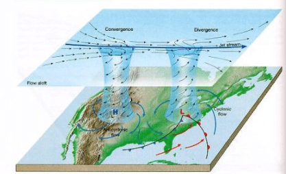
- Favorable upper-level atmospheric conditions: Tropical cyclones require upper-level divergence, meaning that air must be able to spread out and move away from the storm at high altitudes. This allows more air to rise from the surface, maintaining the low pressure at the center of the storm and fueling its growth. Upper-level high-pressure systems or anticyclones can help provide the necessary divergence for tropical cyclone formation.
Good Source of Latent Heat
- Ocean waters with temperatures of 27°C or higher serve as a good source of latent heat, as they provide the moisture needed to fuel storms. The condensation of this moisture releases a significant amount of latent heat of condensation, which drives the storm's development. To maintain this heat source, it is essential that the warm water (26-27°C) extends to a depth of 60-70 meters from the ocean's surface. This depth prevents deep convection currents within the water from mixing cooler water below with the warmer water near the surface.
- This condition is primarily found in the western tropical oceans due to the warm ocean currents that flow from east to west, pushed by easterly trade winds. These currents form a thick layer of water with temperatures greater than 27°C, providing sufficient moisture for storm formation. On the other hand, cold currents in the eastern parts of the tropical oceans reduce surface temperatures, making these regions unsuitable for cyclonic storm development.
Coriolis Force (f)
- The Coriolis force is zero at the equator (no cyclones at the equator because of zero Coriolis Force) but it increases with latitude. Coriolis force at 5° latitude is significant enough to create a storm [cyclonic vortex].
- About 65 percent of cyclonic activity occurs between 10° and 20° latitude.
Low-level Disturbances
- Low-level disturbance (thunderstorms – they are the seeds of cyclones) in the form of easterly wave disturbances in the Inter-Tropical Convergence Zone (ITCZ) should pre-exist.
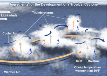
- Small local differences in the temperature of the water and of air produce various low-pressure centers of small size. A weak cyclonic circulation develops around these areas.
- Then, because of the rising warm humid air, a true cyclonic vortex may develop very rapidly. However, only a few of these disturbances develop into cyclones.
[rising of humid air → adiabatic lapse rate → fall in temperature of air → condensation of moisture in air → latent heat of condensation released → air gets more hot and lighter → air is further uplifted → more air comes in to fill the gap → new moisture available for condensation → latent heat of condensation and the cycle repeats]
Temperature contrast between air masses
- Trade winds from both hemispheres converge at the Inter-Tropical Convergence Zone (ITCZ). When the ITCZ is farthest from the equator, there must be a temperature contrast between the air masses from each hemisphere.
- This temperature difference between the air masses creates instability, which is a crucial factor for the development and intensification of powerful tropical storms.
Upper Air Disturbance
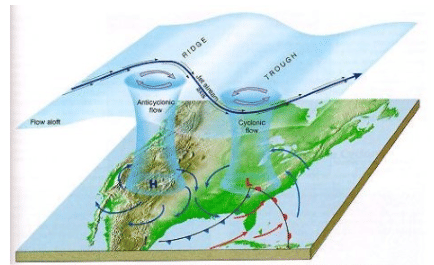
- An upper air disturbance occurs when the remnants of an upper tropospheric cyclone from the Westerlies move deep into tropical latitudes. This happens because divergence, or the process of air moving apart, is predominant on the eastern side of the troughs, causing air to rise and leading to the formation of thunderstorms.
- These old, abandoned troughs, which are the remnants of temperate cyclones, typically have cold cores. This means that the rate at which temperature decreases with altitude (also known as the environmental lapse rate) is steeper and more unstable beneath these troughs. This instability promotes the development of thunderstorms, which can be referred to as "child cyclones."
Wind Shear
- Wind shear refers to the variations in wind speeds at different altitudes. It plays a significant role in the development of tropical cyclones, which tend to form in areas with uniform wind. When there is weak vertical wind shear, the formation of cyclones is primarily restricted to latitudes closer to the equator, as opposed to the subtropical jet stream regions.
- In contrast, temperate regions experience high wind shear due to the presence of westerly winds. This high wind shear makes it difficult for convective cyclones to form in these areas.
Upper Tropospheric Divergence
- A well – developed divergence in the upper layers of the atmosphere is necessary so that the rising air currents within the cyclone continue to be pumped out and a low pressure maintained at the center.
Humidity Factor
- A high level of humidity, typically between 50 to 60 percent, is necessary in the middle layer of the atmosphere for the formation of cumulonimbus clouds. These conditions can be found in the equatorial doldrums, particularly along the western edges of oceans. This is due to the movement of ocean currents from east to west, which results in a higher moisture-carrying capacity.
- The trade winds also play a role in this process, as they continuously replace the saturated air in these regions.
Origin and Development of Tropical Cyclones
- Tropical cyclones are born from heat and develop over tropical seas during the late summer months, typically from August to mid-November. At these times and locations, powerful local convection currents form, which gain a spinning motion due to the influence of the Coriolis effect.
- Once formed, these cyclones travel until they encounter a weak point in the trade wind belt, where they can continue to develop and strengthen.
Origin
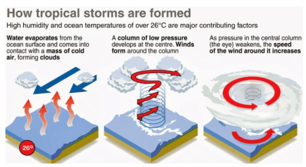
- Under favorable conditions, multiple thunderstorms originate over the oceans. These thunderstorms merge and create an intense low pressure system (wind is warm and lighter).
Early stage
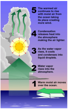
- In the early stage of a thunderstorm, warm and light air rises into the atmosphere. As it reaches a certain altitude, the air temperature drops due to the lapse rate and adiabatic lapse rate, causing the moisture in the air to condense. This condensation process releases latent heat, which in turn warms the air even more, making it lighter and causing it to rise further.
- As this cycle continues, fresh moisture-laden air fills the space and also undergoes condensation, as long as there is a sufficient supply of moisture. Over oceans, where there is an excess of moisture, the thunderstorm intensifies and draws in surrounding air at a faster rate. This incoming air is deflected by the Coriolis force, which creates a cyclonic vortex – a spiraling column of air, similar to a tornado. This process continues and the storm grows, fueled by the ongoing supply of moisture and heat.
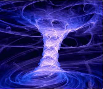
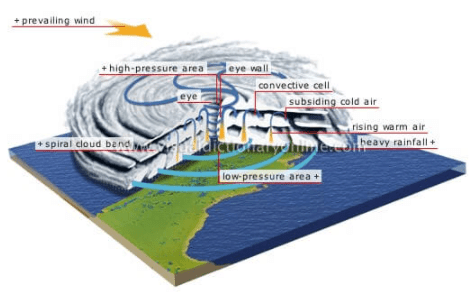
- Due to centripetal acceleration (centripetal force pulling towards the center is countered by an opposing force called the centrifugal force), the air in the vortex is forced to form a region of calmness called an eye at the center of the cyclone. The inner surface of the vortex forms the eyewall, the most violent region of the cyclone.
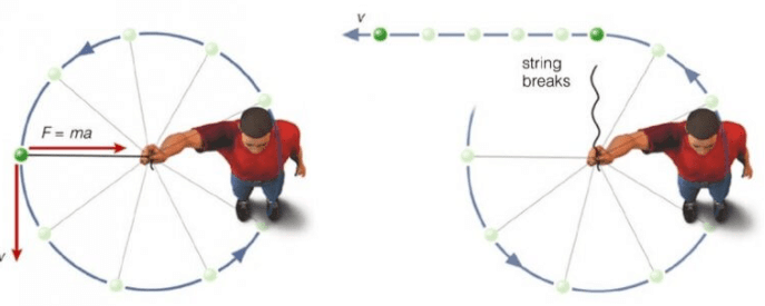
[Eye is created due to tangential force acting on wind that is following a curvy path]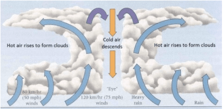 warm Ocean
- All the wind that is carried upwards loses its moisture and becomes cold and dense. It descends to the surface through the cylindrical eye region and at the edges of the cyclone.
- Continuous supply of moisture from the sea is the major driving force behind every cyclone. On reaching the land the moisture supply is cut off and the storm dissipates.
- If ocean can supply more moisture, the storm will reach a mature stage.
Mature stage
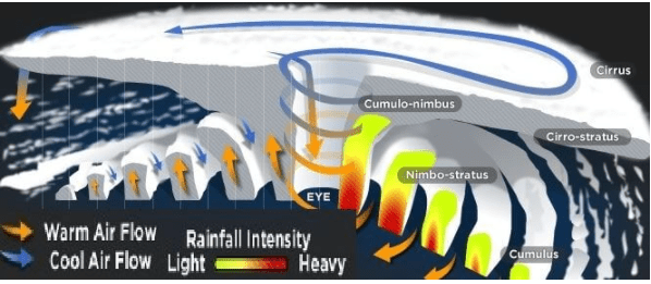
- During the mature stage of a cyclone, the swirling winds create multiple convective cells, resulting in alternating regions of calm and violent weather. In areas with cumulonimbus cloud formation, known as rain bands, intense rainfall occurs due to the rising air within these convective cells. Eventually, the ascending air loses moisture and descends back to the surface through the calm regions that exist between two rain bands.
- Cloud formation is densest at the center of the cyclone, with the size of the clouds decreasing as they move away from the center. Rain bands are primarily composed of cumulonimbus clouds, while the outer edges of the cyclone contain nimbostratus and cumulus clouds.
- At the upper levels of the troposphere, the central dense overcast is made up of cirrus clouds, which consist mostly of hexagonal ice crystals. Dry air flows along the central dense overcast and descends at the periphery and within the eye region of the cyclone.
Structure of a tropical cyclone
Eye
- The eye of a mature tropical cyclone is a distinct feature characterized by a circular area of relatively calm winds, clear skies, and mild weather situated at the storm's center. This region has minimal precipitation, and sometimes even blue skies or stars can be visible.
- The eye of a tropical cyclone also has the lowest surface pressure and the warmest temperatures in the upper atmosphere, with temperatures at an altitude of 12 km potentially being 10°C warmer or more than the surrounding environment. However, at the surface, the temperature difference is much smaller, ranging between 0-2°C.
- The size of a cyclone's eye can vary greatly, with diameters ranging from 8 km to over 200 km. However, most eyes are typically about 30-60 km in diameter.
Eye wall
- The eye of a tropical cyclone is encircled by the "eyewall," a roughly circular ring of deep convection where the highest surface winds and maximum sustained winds of the cyclone can be found. The eyewall experiences an overall upward flow due to the presence of moderately strong to occasionally intense convection.
- The eye itself contains air that is slowly sinking, leading to warmer temperatures within the eye due to the compressional warming (adiabatic) of the descending air. Most observations taken within the eye reveal a moist lower layer with an inversion above, indicating that the sinking air typically does not reach the ocean surface but stops at around 1-3 km above it.
- The eyewall region not only has the fastest winds in a cyclone but also experiences torrential rainfall. Additionally, rainbands may extend outward from the eyewall, with cumulus and cumulonimbus clouds drifting into the outer areas of the cyclone.
Spiral bands
- Tropical cyclones possess a unique feature called spiral bands, which contribute to the formation and maintenance of the storm's eye. These long, narrow rain bands are organized in a way that aligns with the horizontal wind direction, creating a spiraling appearance as they move towards the center of the cyclone.
- The spiral bands are characterized by strong convection, leading to low-level convergence and upper-level divergence. This creates a circulation pattern where warm, moist air converges at the surface and rises through the bands, diverging at higher altitudes before descending on both sides of the bands.
- The descending air undergoes adiabatic warming and dries out. This subsidence is more concentrated on the inner side of the band, causing a more significant warming effect and a sharp pressure drop across the band as the warmer air is lighter than the colder air. This pressure difference results in an increased pressure gradient, leading to stronger tangential winds surrounding the tropical cyclone.
- Over time, the spiral band moves towards the center of the cyclone and encircles it, giving rise to the formation of the eye and the eyewall. The clear, cloud-free eye may be the result of both dynamic forces that push mass from the eye into the eyewall and the forced downward movement caused by the moist convection in the eyewall.
Vertical Structure of a Tropical Cyclone
- The first section, known as the inflow layer, extends up to 3 km in altitude and is responsible for fueling the storm. Air flows into this layer and supplies the storm with the necessary energy to sustain itself.
- The second section, the middle layer, ranges from 3 km to 7 km in altitude, and is where the primary cyclonic activity occurs. This is where the storm's powerful winds, rainfall, and other weather phenomena are generated.
- The third section, the outflow layer, is located above 7 km in altitude. The maximum outflow takes place at 12 km and higher, with air moving in an anticyclonic manner, or opposite to the direction of the rotation of the Earth. This layer helps to release heat and moisture from the storm and contributes to its overall circulation.
- Overall, the vertical structure of a tropical cyclone is a complex system composed of different layers, each playing a crucial role in the development, maintenance, and dissipation of the storm.
Categories of Tropical Cyclones
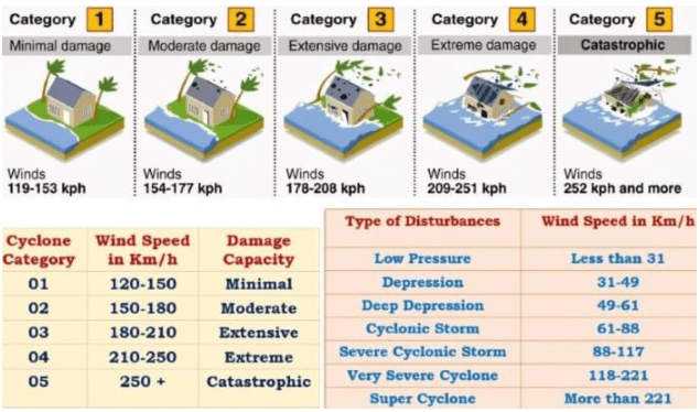
The tropical cyclone category system, as utilized by the Bureau of Meteorology, classifies cyclones into five categories based on the strength of their winds:
- Category one (tropical cyclone): This type of cyclone has gale-force winds with gusts typically ranging from 90 to 125 kph over open, flat land.
- Category two (tropical cyclone): A category two cyclone features destructive winds with gusts typically ranging from 125 to 164 kph over open, flat land.
- Category three (severe tropical cyclone): This category includes cyclones with very destructive winds, with gusts typically ranging from 165 to 224 kph over open, flat land.
- Category four (severe tropical cyclone): A category four cyclone also has very destructive winds, but with gusts typically ranging from 225 to 279 kph over open, flat land.
- Category five (severe tropical cyclone): The most severe type of cyclone, category five cyclones have extremely destructive winds with gusts typically exceeding 280 kph over open, flat land.
Favorite Breeding Grounds for Tropical Cyclones
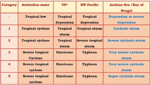
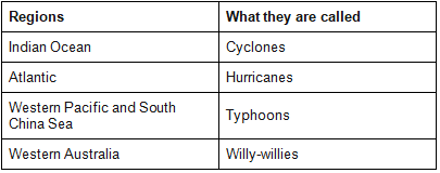
- South-east Caribbean region where they are called hurricanes.
- Philippines islands, eastern China, and Japan where they are called typhoons.
- The Bay of Bengal and the Arabian Sea where they are called cyclones.
- Around the south-east African coast and Madagascar-Mauritius islands.
- North-west Australia.
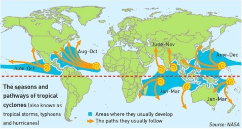
Regional names for Tropical Cyclones
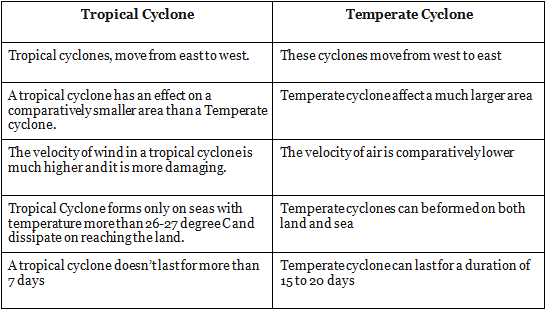
Characteristics of Tropical Cyclones
Tropical cyclones have several distinct features, which are described below.
- Size and Shape: These cyclones are typically elliptical, with a 2:3 ratio of length to width, and have steep pressure gradients. They are relatively compact, with a size of about 80 km near the center, but can expand to anywhere between 300 km and 1500 km.
- Wind Velocity and Strength: The wind speed within a tropical cyclone is greater near the poles than at the center, and is higher over oceans than over landmasses, which have physical barriers. The wind velocity can range from zero to 1200 km per hour.
- Path of Tropical Cyclones: Tropical cyclones initially move westward, but turn northward around 20° latitude. They then turn further northeastward around 25° latitude, and finally eastward around 30° latitude, where they lose energy and dissipate. Their paths follow a parabolic shape, with their axes parallel to isobars. Factors such as the Coriolis force, easterly and westerly winds, and Earth's rotation influence the path of tropical cyclones. These cyclones dissipate at 30° latitude due to cooler ocean waters and increasing wind shear caused by westerly winds.
- Warning of Tropical Cyclones: To detect potential cyclones, weather stations monitor changes in pressure, wind velocity, and the storm's direction and movement. There are weather stations located
Major Differences between Temperate Cyclone and Tropical Cyclone
Tornado
A tornado can be described as an intensely spinning column of air that reaches from a thunderstorm all the way down to the earth's surface. It essentially functions as a whirlwind of high-speed air. The formation of a tornado occurs when alterations in wind velocity and direction generate a horizontal spinning motion within a storm cell. This spinning motion is subsequently turned vertical by the upward movement of air through the thunderclouds.
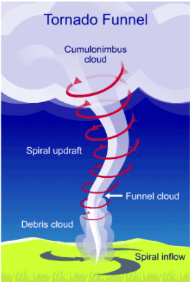
- Tornadoes are powerful weather events characterized by their high-velocity winds, which can exceed 500 km/h (310 mph). The majority of the damage caused by tornadoes is due to these strong winds. Additionally, tornadoes can cause damage through significant air pressure reductions at their center, which is about 800 millibars, compared to the average sea-level pressure of 1013 millibars. This pressure difference can cause many human-made structures to collapse outward.
- The formation of tornadoes typically requires four primary ingredients: wind shear, lift, instability, and moisture. Wind shear, which is the change in wind speed or direction with altitude, plays the most crucial role in creating tornadoes. This phenomenon can cause winds to form a horizontal column of air. When a strong updraft, or rising air, transports this air from the ground to the atmosphere, the column becomes vertical, often leading to the development of a storm.
- In many cases, the storm evolves into a supercell thunderstorm, which is a discrete, individual storm cell that is not part of a larger line of storms. Supercell thunderstorms are characterized by their rotation and spinning motion. The combination of a vertical, rotating column of air and a supercell thunderstorm can result in the formation of a tornado descending from the storm cloud.
- Tornadoes are most commonly observed during the spring, with a decrease in frequency during the winter months. Spring and fall experience peaks in tornado activity due to the presence of stronger winds, increased wind shear, and greater atmospheric instability. The occurrence of tornadoes is also highly dependent on the time of day, as solar heating plays a significant role in their formation.
Distribution of tornadoes
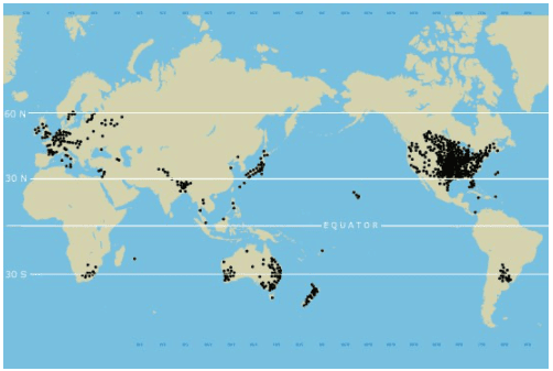
- Tornadoes are rare in polar regions and are infrequent at latitudes higher than 50° N and 50° S. They are more likely to occur in temperate and tropical regions, where thunderstorms are more common. Tornadoes have been reported on every continent except Antarctica.
- The United States experiences the highest number of violent tornadoes, followed by Canada, which reports the second-highest number of tornadoes overall. In the Indian subcontinent, Bangladesh is the country most susceptible to tornadoes. At any given time, there are approximately 1,800 thunderstorms happening around the world, which contribute to the formation of tornadoes in the most prone areas.
Differences between Tornado and cyclone
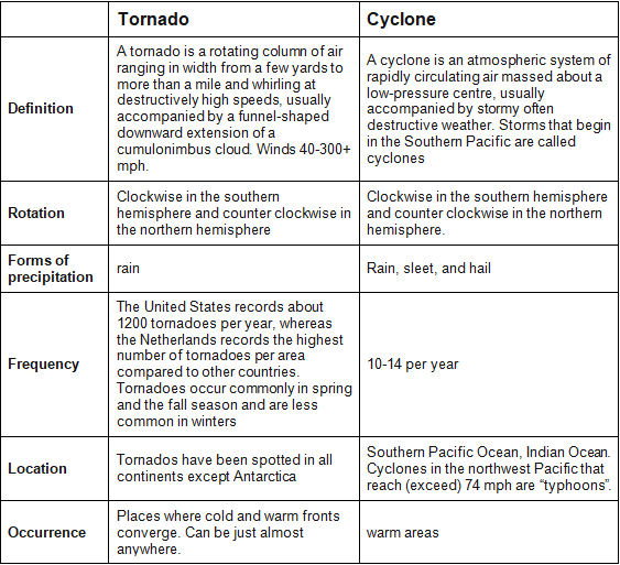
Tornadoes, as well as cyclones both, occur in India. However, unlike cyclones, the frequency of tornado outbreaks is very low. Cyclones originate in the Bay of Bengal region as well as in the Arabian Sea region whereas Tornadoes of weak strength occur in the north-western and north-eastern region of the country causing significant damage to man and material.
Temperate Cyclone
Temperate cyclones are storm systems that form in the middle and high latitudes, outside of the tropical regions. These low-pressure systems are characterized by the presence of cold fronts, warm fronts, and occluded fronts. They are also known as extra-tropical cyclones, mid-latitude cyclones, frontal cyclones, or wave cyclones. These weather systems develop between 35° and 65° latitude in both the Northern and Southern hemispheres, beyond the tropical zones.Origin and Development of Temperate Cyclones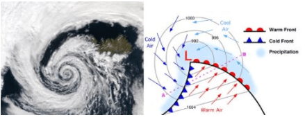
Polar Front Theory
- The Polar Front Theory explains the formation of extratropical cyclones, which occur when warm, humid air masses from the tropics meet cold, dry air masses from the poles. This interaction creates a polar front, a boundary where the two air masses meet. This typically occurs over subtropical high and subpolar low-pressure belts, as well as along the tropopause.
- As the cold air pushes the warm air upwards, a void is created due to the decrease in pressure. The surrounding air rushes in to fill this void, and the Earth's rotation causes a cyclone to form, which moves with the westerlies, or jet streams.
- In the Northern Hemisphere, warm air blows from the south, and cold air blows from the north of the polar front. When the pressure drops along the front, the warm air moves northward, and the cold air moves southward, creating an anticlockwise cyclonic circulation due to the Coriolis Force.
- This cyclonic circulation leads to the formation of a well-developed extratropical cyclone, which has both a warm front and a cold front. There are pockets of warm air, or warm sectors, wedged between the forward cold air and the rear cold air, or cold sectors. The warm air glides over the cold air, resulting in a sequence of clouds appearing in the sky ahead of the warm front, causing precipitation.
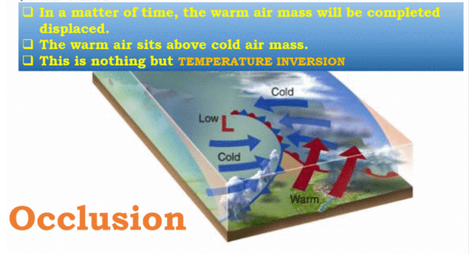
- The cold front approaches the warm air from behind, pushing the warm air upwards and leading to the development of cumulus clouds along the cold front. Since the cold front moves faster than the warm front, it eventually overtakes it, lifting the warm air completely and resulting in an occluded front. The cyclone then dissipates.
- The wind circulation processes at both the surface and aloft are closely interconnected, making the temperate cyclone a complex system primarily involving occlusion-type fronts. Typically, individual frontal cyclones last for about 3 to 10 days and move in a generally west-to-east direction. The exact movement of these weather systems is determined by the orientation of the polar jet stream in the upper troposphere.
Seasonal Occurrence of Temperate Cyclones
- The temperate cyclones occur mostly in winter, late autumn and spring. They are generally associated with rainstorms and cloudy weather.
- During summer, all the paths of temperate cyclones shift northwards and there are only few temperate cyclone over sub-tropics and the warm temperate zone, although a high concentration of storms occurs over Bering Strait, USA and Russian Arctic and sub-Arctic zone.
Distribution of Temperate Cyclones
- USA and Canada – extend over Sierra Nevada, Colorado, Eastern Canadian Rockies and the Great Lakes region,
- the belt extending from Iceland to Barents Sea and continuing over Russia and Siberia,
- winter storms over Baltic Sea,
- Mediterranean basin extending up to Russia and even up to India in winters (called western disturbances) and the Antarctic frontal zone.
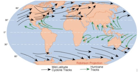
Characteristics of Temperate Cyclones
Size and Shape- The temperate cyclones are asymmetrical and shaped like an inverted ‘V’.
- They stretch over 500 to 600 km.
- They may spread over 2500 km over North America (Polar Vortex).
- They have a height of 8 to 11 km.
Wind Velocity And Strength
- The wind strength is more in eastern and southern portions, more over North America compared to Europe.
- The wind velocity increases with the approach but decreases after the cyclone has passed.
Orientation And Movement
- Jet stream plays a major role in temperate cyclonogeneis.
- Jet streams also influence the path of temperate cyclones.
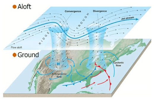
- Since these cyclones move with the westerlies (Jet Streams), they are oriented eastwest.
- If the storm front is east-west, the center moves swiftly eastwards.
- If the storm front is directed northwards, the center moves towards the north, but after two or three days, the pressure difference declines and the cyclone dissipates.
- In case the storm front is directed southwards, the center moves quite deep southwards-even up to the Mediterranean region [sometimes causing the Mediterranean cyclones or Western Disturbances (They are very important as they bring rains to North-West India – Punjab, Haryana)].
Structure
- The north-western sector is the cold sector and the north-eastern sector is the warm sector (Because cold air masses in north and warm air masses in south push against each other and rotate anti-clockwise in northern hemisphere).
Associated Weather
- The onset of a temperate cyclone is characterized by a drop in temperature, a decrease in the mercury level, shifting winds, and the appearance of a halo around the sun and moon, as well as a thin layer of cirrus clouds. A light drizzle begins, eventually turning into a heavy downpour. However, these conditions change with the arrival of the warm front, which stops the mercury level from falling and causes the temperature to rise.
- At this point, the rainfall ceases and the weather clears up until the cold front with an anticyclonic nature comes in. This front leads to a drop in temperature, increased cloudiness, and rainfall accompanied by thunder. After this, clear weather returns once more.
- Temperate cyclones typically produce more rainfall when they move slowly and have a significant difference in rainfall and temperature between the front and rear of the cyclone. These cyclones are often accompanied by anticyclones.
Conclusion
Tropical and temperate cyclones are powerful and complex weather systems that form in different regions and under varying conditions. Tropical cyclones develop over warm ocean waters in the tropical regions and are fueled by latent heat, while temperate cyclones form in the middle and high latitudes through the interaction of cold and warm air masses. Both types of cyclones can cause significant damage and impact human life and infrastructure. Tornadoes, although less frequent, are also intense and destructive weather events that result from specific atmospheric conditions. Understanding the formation, development, and characteristics of these weather phenomena is crucial for accurate forecasting and effective disaster preparedness.Frequently Asked Questions (FAQs) of Temperate & Tropical Cyclones
What is the main difference between tropical cyclones and temperate cyclones?
The main difference between tropical and temperate cyclones is their location and formation process. Tropical cyclones form in tropical regions over warm ocean waters and are characterized by a warm core and closed air circulation around a low-pressure center. Temperate cyclones, on the other hand, form in middle and high latitude regions and involve interactions between cold and warm air masses, leading to the formation of fronts.
What are the favorable conditions for tropical cyclone formation?
Favorable conditions for tropical cyclone formation include warm ocean waters with a temperature of at least 27°C, sufficient Coriolis effect, minimal vertical wind shear, an existing disturbance or low-pressure system, and favorable upper-level atmospheric conditions, such as upper-level divergence.
Why are tropical cyclones more common in the western tropical oceans?
Tropical cyclones are more common in the western tropical oceans due to the presence of warm ocean currents that flow from east to west, pushed by easterly trade winds. These currents form a thick layer of water with temperatures greater than 27°C, providing sufficient moisture for storm formation. In contrast, cold currents in the eastern parts of the tropical oceans reduce surface temperatures, making these regions unsuitable for cyclonic storm development.
What are the various names for tropical cyclones in different regions of the world?
Tropical cyclones have different names depending on where they develop in the world. They are known as hurricanes in the Atlantic and eastern Pacific, typhoons in the western Pacific, and cyclones in the Indian Ocean and the South Pacific.
How can people prepare for and protect themselves from tropical cyclones?
To prepare for tropical cyclones, people should stay informed about weather forecasts and warnings, develop an emergency plan, and assemble an emergency supplies kit. During a tropical cyclone, individuals should stay indoors, away from windows and glass doors, and follow instructions from local authorities. After the cyclone has passed, it is essential to exercise caution when returning home or venturing outside, as there may be damage and hazards present.
|
303 videos|636 docs|252 tests
|


