Recent Views on Mountain Building | Geography Optional for UPSC PDF Download
| Table of contents |

|
| Introduction |

|
| Geosynclines |

|
| Views of Schuchert |

|
| Stages of Geosynclines |

|
| Frequently Asked Questions (FAQs) of Recent Views on Mountain Building |

|
Introduction
Orogeny refers to the crucial geological process responsible for the formation and differentiation of the Earth's crust. In 1890, American geologist G.K. Gilbert coined the term 'orogeny' to describe the process of mountain building, specifically focusing on the formation of fold mountain belts like the Alps and the Rockies. As defined by the Oxford Dictionary of Geography, 'orogeny' refers to the tectonic movements of the Earth that involve the folding of sediments, faulting, and metamorphism.
- There are two primary types of orogeny: the cordilleran type, which involves the severe deformation of geosynclinal deposits, and the type formed by continental collision, in which oceanic crust and sediment are trapped between two masses of continental crust. The term 'orogeny' is not applicable to submerged mountains found in seas, as these underwater mountains are formed through processes that are significantly different from those responsible for creating mountain systems like the Alps and the Rockies.
- Two modern theories attempt to explain mountain building: the Geosynclinal theory and the Plate Tectonic theory. Both theories offer different perspectives on the geological processes involved in the formation of mountains and the Earth's crust.
Geosynclines
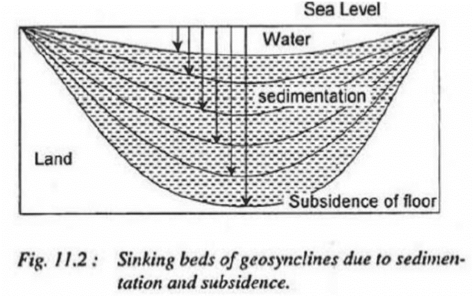
Geosynclines are significant geological features that have played a crucial role in the formation and development of the Earth's continents and ocean basins. These shallow, long, and narrow depressions of water are characterized by gradual sedimentation and subsidence. They are believed to have originated from mobile water zones surrounded by stable, rigid landmasses, which are the ancient nuclei of present-day continents.- Geosynclines have not remained constant throughout geological history; their location, shape, dimensions, and extent have undergone significant changes due to various earth movements and geological processes. These depressions are typically bordered by two rigid masses called forelands, forming the edges of the geosynclinal regions.
- The concept of geosynclines was first introduced by James Hall and Dana, but it was further developed and expanded upon by Haug. J.A. Steers (1932) acknowledged their contributions, stating, "While the theory of geosynclines is due to Haug, the concept of the idea belongs to Hall and Dana." Geosynclinal theory gained widespread acceptance as it shed light on the unique features of folded mountains and the processes involved in their formation.
In summary, geosynclines are long, narrow, and shallow water depressions that have played a crucial role in the Earth's geological history. Their continuous sedimentation and subsidence have contributed to the formation of mountains and other landforms. The concept of geosynclines has evolved over time, thanks to the work of various geologists and geographers who have further developed and refined the theory.
Concept of Hall and Dana
The concept of Hall and Dana revolves around the study of folded mountains and their relationship with geosynclines. Dana examined the sediments found in the rocks of these mountains and theorized that they originated from marine sources. He proposed that these sediments were deposited in elongated, narrow, and shallow seas, which he referred to as geosynclines.
- Dana was the first to define geosynclines as long, narrow, and shallow sinking beds of seas. Hall further developed this concept, providing substantial evidence to demonstrate a connection between geosynclines and folded mountains. He argued that the rocks found in folded mountains were initially deposited in shallow seas, which eventually formed geosynclines.
- According to Hall, the continuous process of sedimentation causes the beds of geosynclines to subside. However, despite this subsidence, the depth of water in these geosynclines remains constant. It is important to note that geosynclines are characterized by their length, which is significantly greater than their width. This concept of Hall and Dana provides a foundation for understanding the geological processes that contribute to the formation of folded mountains and their relationship with geosynclines.
Concept of E. Haug
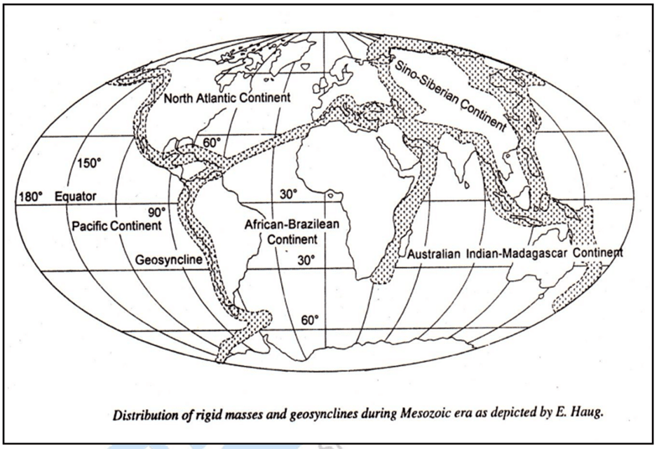
- The concept of geosynclines, credited to Hall and Dana, was further developed by E. Haug. He defined geosynclines as long, deep bodies of water that were much longer than they were wide. Haug created paleogeographical maps of the world, illustrating the long and narrow oceanic tracts that were later folded into mountain ranges.
- Haug proposed that the locations of present-day mountains were once occupied by geosynclines or oceanic tracts. These geosynclines existed as mobile water zones between rigid masses. He identified five major rigid masses during the Mesozoic era: the North Atlantic Mass, the Sino-Siberian Mass, the Africa-Brazil Mass, the Australia-India-Madagascar Mass, and the Pacific Mass. He also located four geosynclines between these ancient rigid masses: the Rockies geosyncline, the Ural geosyncline, the Tethys geosyncline, and the Circum-Pacific geosyncline.
- According to Haug, systematic sedimentation occurred in the geosynclines. The littoral margins of the geosynclines were impacted by transgressional and regressional phases of the seas. The marginal areas of the geosynclines contained shallow water where larger sediments were deposited, while finer sediments were deposited in the central parts of the geosynclines. These sediments were compressed and folded into mountain ranges due to the compressive forces coming from the margins of the geosynclines.
- Haug also noted that not all geosynclines necessarily went through the complete cycle of sedimentation, subsidence, compression, and folding of sediments. In some cases, mountains were not formed from the geosynclines despite continuous sedimentation over long geological time periods.
- While Haug's contributions to the development of the geosyncline concept are commendable, his theory has some limitations and confusing aspects. For instance, his paleogeographic map of the Mesozoic era depicted an unrealistic extent of rigid masses (land areas) compared to the geosynclines (oceanic areas).
Concept of J.W. Evans
J.W. Evans posits that geosynclines are highly diverse in their forms and locations, which makes it challenging to provide a clear definition for their shape and position. Geosynclines are characterized by their beds undergoing gradual subsidence due to sedimentation, and their forms and shapes evolve in response to changing environmental conditions. As a result, a geosyncline can be either narrow or wide and take on various shapes.
There are several possible scenarios for the placement of geosynclines:
- They can be situated between two land masses, such as the Tethys geosyncline that was located between Laurasia and Gondwanaland.
- They can be found in front of a mountain or plateau, like the long trench that formed after the Himalayas' emergence, which was later filled with sediments to create the Indo-Gangetic Plains.
- They can be positioned along the edges of continents.
- They can be present in front of a river mouth, among other locations.
Evans emphasizes that all geosynclines, despite their diverse forms, shapes, and locations, share the common features of sedimentation and subsidence. Over time, geosynclines that have experienced prolonged periods of sedimentation eventually become compressed and folded, giving rise to mountain ranges.
Views of Schuchert
Schuchert's classification of geosynclines focused on their characteristics, such as size, location, and evolutionary history. He divided them into three categories:- Monogeosynclines: These are exceptionally long, narrow, and shallow water tracts, as described by Hall and Dana. Monogeosynclines are situated either within a continent or along its borders and are characterized by continuous subsidence due to gradual sedimentation and the resulting load. They are called "mono" because they undergo only one cycle of sedimentation and mountain building. The Appalachian geosyncline in the United States is considered the best example of monogeosynclines. It was present during the Pre-Cambrian period and bordered by the highland mass known as Appalachia in the east. The Appalachian geosyncline experienced folding from the Ordovician to Permian periods.
- Polygeosynclines: These are long and wide water bodies, broader than monogeosynclines. Polygeosynclines have relatively longer lifespans and more complex evolutionary histories. They are thought to have experienced more than one phase of orogenesis, leading to the formation of one or more parallel geanticlines arising from their floors during the squeezing process. Polygeosynclines originated in positions similar to those of monogeosynclines. The Rocky and Ural geosynclines are representative examples of polygeosynclines.
- Mesogeosynclines: These are very long, narrow, and mobile ocean basins that are surrounded by continents on all sides. Mesogeosynclines are characterized by great abyssal depths and long, complex geological histories. They undergo several geosynclinal phases, such as sedimentation, subsidence, and folding. Mesogeosynclines are similar to the geosynclines described by Haug. The Tethys geosyncline is a typical example of this type, and the Mediterranean Sea is its remnant. The Tethys geosyncline was folded into the Alpine mountains of Europe and the Himalayas of Asia. The unfolded remaining portion of the Tethys geosyncline became the Mediterranean Sea, an example of Kober's median mass.
Concept of Arthur Holmes
A. Holmes, a renowned geologist, has made significant contributions to the understanding of geosynclines, including their main characteristics, causes of origin, and the processes involved in sedimentation, subsidence, and orogenesis. He believed that sedimentation leads to subsidence, but this alone cannot account for the greater thickness of sediments in geosynclines. Instead, earth movements can cause substantial subsidence in geosynclinal beds. Holmes also noted that the subsidence of geosynclinal beds occurs gradually, not suddenly.
For instance, the deposition of sediments up to 12,160 meters (40,000 feet) thick in the Appalachian geosyncline could have occurred over a 300-million-year span from the Cambrian period to the early Permian period, at a rate of one foot of sedimentation every 7,500 years.
Holmes identified four major types of geosynclines and described their origins separately:
- Geosynclines formed by magma migration: Holmes posited that the earth's crust consists of three layers, and the migration of magma from the intermediate layer to neighboring areas can cause the collapse and subsidence of the outer layer, forming a geosyncline. The Coral Sea is a present-day example of this process.
- Geosynclines formed by metamorphism: Holmes argued that converging convective currents cause compression-induced metamorphism in the lower layer of the crust, increasing the density of rocks and causing subsidence, which leads to the formation of a geosyncline. The Caribbean Sea, western Mediterranean Sea, and Banda Sea are examples of this type of geosyncline. However, this concept has been criticized because compression caused by convergent convective currents might not result in metamorphism, but rather in the melting of rocks due to high temperatures.
- Geosynclines formed by compression: Some geosynclines result from compression and subsequent subsidence of the outer crustal layer caused by convergent convective currents. The Persian Gulf and the Indo-Gangetic trough are considered typical examples of this type of geosyncline.
- Geosynclines formed by thinning of the sialic layer: Holmes suggested two possibilities when a column of rising convective currents diverges in opposite directions after reaching the lower crustal layer: (a) the sialic layer stretches apart due to tensile forces exerted by diverging convective currents, causing thinning and resulting in the creation of a geosyncline, such as the former Tethys geosyncline; or (b) the continental mass may separate due to enormous tensile forces generated by the divergent convective currents, as is thought to have occurred in the formation of the former Ural geosyncline.
View of Others
Dustar has categorized geosynclines into three types based on the structure of mountain ranges:
- Inter-continental geosynclines are located between two continental or land masses. This type is similar to Schuchert's mesogeosyncline classification. The Ural geosyncline is a representative example of this category.
- Circum-continental geosynclines are typically found along the edges of continents. This type corresponds to Schuchert's monogeosyncline classification.
- Circum-oceanic geosynclines are generally situated in the marginal areas where continents meet oceanic margins. Stille refers to these as marginal geosynclines, while others call them special or unique geosynclines. More extensive geosynclines are referred to as orthogeosynclines by Stille.
Stille has also classified geosynclines based on the presence of volcanic activity during their formation:
- Eugeosynclines have a relatively high amount of volcanic products, indicating a high level of igneous activity (the Greek prefix "eu" means high status).
- Miogeosynclines contain a lower amount of volcanic products, suggesting a lower level of igneous activity (the prefix "mio" means low).
In summary, Dustar's classification of geosynclines involves three types based on their location in relation to continents and oceans, while Stille's classification is based on the level of volcanic activity during the formation of geosynclines.
Stages of Geosynclines
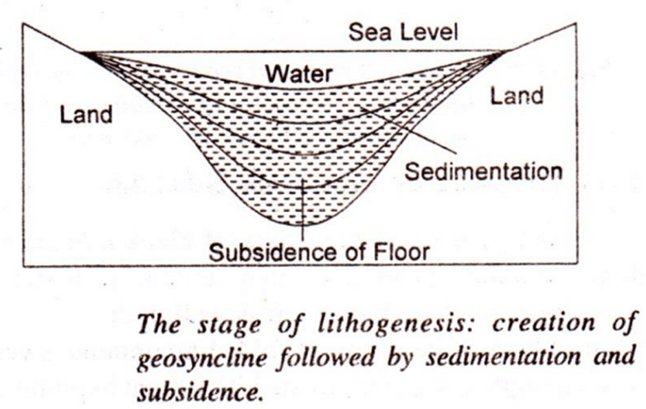
The geosynclinal history is divided into three main stages, including:Lithogenesis (the stage of geosyncline formation, sedimentation, and subsidence of geosynclinal beds):
- This stage is characterized by the formation, sedimentation, and subsidence of geosynclines. These geosynclines form due to the contraction caused by the Earth's cooling process. The adjacent stable areas or kratogens, which surround the geosynclines, are subjected to the forces of erosion.
- As a result, rocks and boulders from the kratogens are continuously worn away and deposited onto the beds of the geosynclines. This leads to the subsidence of the geosynclines, as the weight of the deposited sediments causes them to sink. The combined processes of sediment deposition and the resulting subsidence contribute to the ongoing accumulation of sediments, which increases the overall thickness of the geosynclinal beds.
Orogeneis (the stage of squeezing and folding of geosynclinal sediments into mountain ranges:
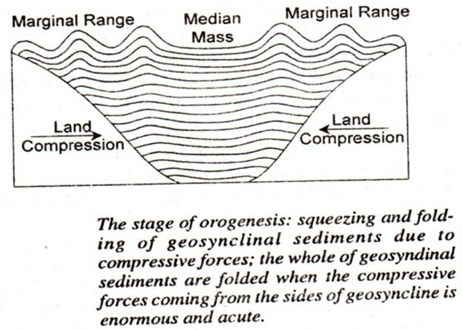
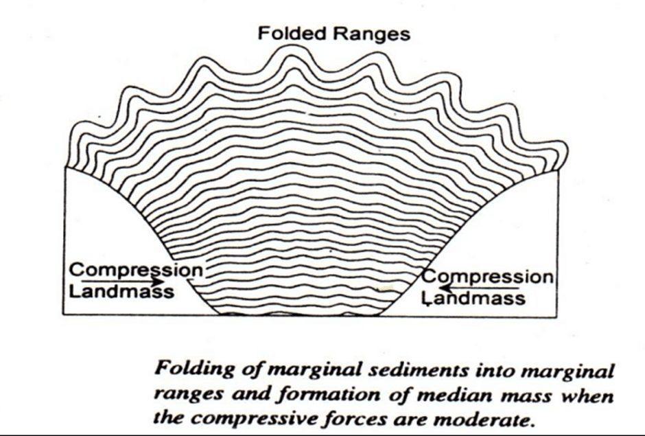
- In this stage the geosynclinal sediments are squeezed and folded into mountain ranges. There is a convergence of forelands towards each other due to the force of the contraction of the earth. The enormous compressive forces produced by these moving forelands produce contraction, squeezing and folding of sediments deposited on the geosynclinal bed.
- The parallel mountain ranges found on both sides of the geosyncline have been termed by Kober as rand ketten meaning marginal ranges. Kober viewed the folding of geosynclinal sediments to be dependent upon the intensity of the compressive forces. Compressive forces of normal and moderate intensity produce marginal ranges on two sides of the geosyncline leaving the middle part unaffected.
- The unfolded middle part is termed as zwischengebirge (between mountains) or median mass. He viewed the Tethys geosyncline as bordered by the European foreland in the north and by the African foreland in the south.
- The sedimentary deposits of the Tethys geosyncline had undergone massive compression due to the converging movement of the European landmass (foreland) and the African foreland, leading to the formation of the Alpine mountain system.
Gliptogenesis (the stage of gradual rise of mountains, and their denudation and consequent lowering of their heights):
- This phase of mountain- building is characterized by a gradual ascent of mountain ranges and the ongoing denudation processes by natural agents.
Conclusion
Orogeny is a crucial geological process responsible for the formation and differentiation of the Earth's crust, specifically the creation of fold mountain belts. Geosynclines, long and narrow depressions of water, play a significant role in the Earth's geological history, including the formation of mountains and other landforms. Various geologists and geographers have contributed to our understanding of geosynclines, their relationship with mountain building, and their classifications. The study of geosynclines and orogeny helps us understand the complex processes that have shaped the Earth's crust and contributed to the formation of the diverse landscapes we see today.Frequently Asked Questions (FAQs) of Recent Views on Mountain Building
What is orogeny, and what are the two primary types of orogeny?
Orogeny refers to the geological process responsible for the formation and differentiation of the Earth's crust, specifically focusing on the formation of fold mountain belts. The two primary types of orogeny are the cordilleran type, which involves the severe deformation of geosynclinal deposits, and the type formed by continental collision, in which oceanic crust and sediment are trapped between two masses of continental crust.
What are geosynclines, and how do they contribute to the formation of mountains?
Geosynclines are long, narrow, and shallow water depressions that have played a crucial role in the Earth's geological history. Their continuous sedimentation and subsidence have contributed to the formation of mountains and other landforms. The concept of geosynclines has evolved over time, thanks to the work of various geologists and geographers who have further developed and refined the theory.
What is the difference between monogeosynclines, polygeosynclines, and mesogeosynclines?
Monogeosynclines are long, narrow, and shallow water tracts that undergo only one cycle of sedimentation and mountain building. Polygeosynclines are long and wide water bodies that have relatively longer lifespans and more complex evolutionary histories, experiencing more than one phase of orogenesis. Mesogeosynclines are very long, narrow, and mobile ocean basins that are surrounded by continents on all sides, characterized by great abyssal depths and long, complex geological histories.
How do the concepts of Hall and Dana, E. Haug, J.W. Evans, and Arthur Holmes contribute to our understanding of geosynclines?
The concepts of Hall and Dana were the first to define geosynclines and establish a connection between them and folded mountains. E. Haug further developed the concept, identifying major geosynclines and their relationships with rigid landmasses. J.W. Evans emphasized the diversity of geosynclines in terms of their forms and locations. Arthur Holmes contributed by explaining the possible origins and causes of geosynclines, as well as the processes involved in sedimentation, subsidence, and orogenesis.
What are the three main stages of geosynclinal history?
The three main stages of geosynclinal history are lithogenesis (the stage of geosyncline formation, sedimentation, and subsidence of geosynclinal beds), orogeneis (the stage of squeezing and folding of geosynclinal sediments into mountain ranges), and gliptogenesis (the stage of the gradual rise of mountains and their denudation and consequent lowering of their heights).
|
303 videos|636 docs|252 tests
|
FAQs on Recent Views on Mountain Building - Geography Optional for UPSC
| 1. What are geosynclines? |  |
| 2. What are the views of Schuchert regarding geosynclines? |  |
| 3. What are the stages of geosynclines? |  |
| 4. What are the recent views on mountain building? |  |
| 5. How do recent views on mountain building differ from the views of Schuchert? |  |


