Air Masses and Fronts | Geography Optional for UPSC PDF Download
| Table of contents |

|
| Air Mass |

|
| Classification of Air Masses |

|
| Characteristics of Fronts |

|
| Air Masses, Fronts, and Major Atmospheric Disturbances |

|
| Frequently Asked Questions (FAQs) of Air Masses and Fronts |

|
Air Mass
- An air mass is a large body of air that has acquired specific characteristics in terms of temperature and humidity due to remaining over a homogeneous area for an extended period of time.
- These homogeneous areas can include vast ocean surfaces or expansive plains and plateaus. As a result, the air mass exhibits minimal horizontal variations in temperature and moisture.
- Air masses play a crucial role in the global planetary wind system and are typically associated with specific wind belts. They can span from the Earth's surface to the lower stratosphere, stretching across thousands of kilometers.
Source regions
- Source regions refer to the homogeneous surfaces where air masses form. These regions play a crucial role in establishing heat and moisture equilibrium with the air masses above them. The primary source regions are located in the subtropical high-pressure belts, which give rise to tropical air masses, and around the poles, which serve as the source for polar air masses.
- As an air mass moves away from its source region, the upper level can maintain its physical characteristics for an extended period. This occurs because air masses are typically stable with stagnant air, which does not promote convection, or the vertical movement of air. In such stagnant air, processes like conduction and radiation are not very effective.
Conditions for the formation of Air masses
- For air masses to form, certain conditions must be met. Firstly, the source region, or the area where the air mass originates, should be large and have gentle, divergent air circulation (meaning the air is slightly at high pressure). Ideal source regions are areas with high pressure but minimal pressure difference or gradient.
- It is important to note that there are no major source regions for air masses in mid-latitudes, as these areas are predominantly affected by cyclonic and other weather disturbances.

Conditions for the origin of Air masses
- Homogeneous Surface
- Isotropic surface
- Lack of turbulence in the air
- Lack of convection in air
- Subsiding air with high pressure
- Atmospheric stability
- Kinetic energy of wind and friction
Size and dimension
- Extend till Tropopause
- Width is hundreds of km
- Height varies b/w 8-12 km
- Latitudinal extent varies from 3000-6000 km
Classification of Air Masses
Air masses can be classified based on various factors, which include the nature of the surface, source region, temperature, and atmospheric conditions.- Nature of Surface: Air masses can be categorized as either continental or marine. Continental air masses form over land and are usually dry, whereas marine air masses form over water and are more humid.
- Source Region: The source region refers to the area where the air mass originates. Polar air masses form in high latitude regions and are typically cold and dry, while tropical air masses form in low latitude regions and are warm and moist.
- Temperature: Air masses can be classified as either cold or warm, depending on their temperature. Cold air masses have lower temperatures and warm air masses have higher temperatures. The interaction between cold and warm air masses often leads to changes in weather conditions.
- Atmospheric Conditions: Based on the stability of the atmosphere, air masses can be classified as stable or unstable. Stable air masses are characterized by minimal vertical movement and uniform temperature and humidity, leading to stable weather conditions. Unstable air masses, on the other hand, have significant vertical movement, causing variations in temperature and humidity, and often leading to the development of storms and other severe weather events.
- Broadly, the air masses are classified into polar and tropical air masses.
- Both the polar and the continental air masses can be either of maritime or continental types.
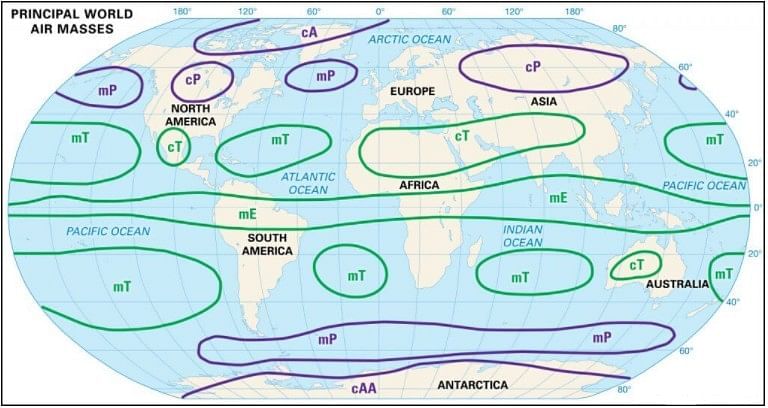
Air masses based on Source Regions
- There are five major source regions. These are:
- Warm tropical and subtropical oceans;
- The subtropical hot deserts;
- The relatively cold high latitude oceans;
- The very cold snow-covered continents in high latitudes;
- Permanently ice-covered continents in the Arctic and Antarctica.
- Accordingly, the following types of airmasses are recognized:
- Maritime tropical (mT);
- Continental tropical (cT);
- Maritime polar (mP);
- Continental polar (cP);
- Continental arctic (cA).
- Tropical air masses are warm and polar air masses are cold.
- The heat transfer processes that warms or cools the air take place slowly.
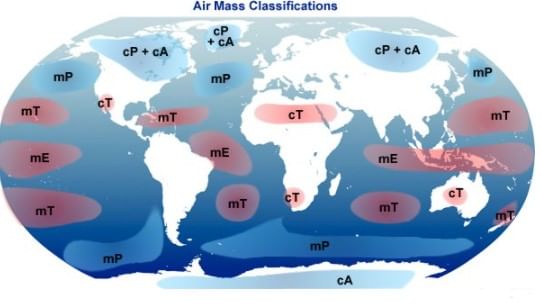
Cold Air Mass
- A cold air mass is one that is colder than the underlying surface and is associated with instability and atmospheric turbulence. (because of moisture and very low temperature)
Cold source regions (polar air masses)
- Arctic Ocean – cold and moist
- Siberia – cold and dry
- Northern Canada – cold and dry
- Southern Ocean – cold and moist
Warm Air Mass
- A warm air mass is one that is warmer than the underlying surface and is associated with stable weather conditions.
Warm source regions (tropical air masses)
- Sahara Desert – warm and dry
- Tropical Oceans – warm and moist
Influence of Air Masses on World Weather
- Air masses play a significant role in shaping the world's weather, as they influence factors such as temperature distribution, moisture content, and atmospheric stability. These properties affect the weather conditions that accompany the air mass.
- Air masses transport moisture from oceans to continents, resulting in precipitation over land areas. This process helps maintain a balance of heat across various latitudes by transferring latent heat.
- Many weather phenomena, such as cyclones and storms, originate at the contact zones between different air masses. The characteristics of these air masses determine the specific weather conditions associated with these disturbances. In summary, the influence of air masses on global weather is vast, as they contribute to various weather events and help regulate temperature and moisture levels across the planet.
Continental Polar Air Masses (CP)
- Air masses known as Continental Polar (CP) originate from regions such as the Arctic basin, northern parts of North America and Eurasia, and Antarctica. These air masses are typically marked by their dry, cold, and stable nature.
- In the winter months, the weather associated with Continental Polar air masses is extremely cold, clear, and stable. However, during the summer, the weather conditions are less stable due to factors such as reduced anticyclonic winds, increased warmth from landmasses, and decreased snow cover.
Maritime Polar Air Masses (MP)
- These air masses originate from the oceanic regions located between 40° and 60° latitudes. They are initially continental polar air masses that have traveled over warmer ocean waters, causing them to heat up and gather moisture.
- The conditions in the source regions of these air masses are cool, moist, and unstable, making it difficult for them to remain stationary for extended periods. The weather associated with maritime polar air masses during winter includes high humidity, overcast skies, and occasional occurrences of fog and precipitation.
- In contrast, the summer weather associated with these air masses is generally clear, pleasant, and stable.
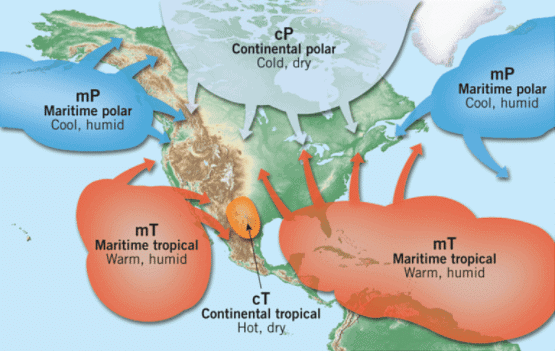
Continental Tropical Air Masses (CT)
- The source-regions of the air masses include tropical and sub-tropical deserts of Sahara in Africa, and of West Asia and Australia.
- These air masses are dry, hot and stable and do not extend beyond the source.
- They are dry throughout the year.
Maritime Tropical Air Masses (MT)
- The source regions of these air masses include the oceans in tropics and sub-tropics such as Mexican Gulf, the Pacific, and the Atlantic oceans.
- These air masses are warm, humid, and unstable.
- The weather during winter has mild temperatures, overcast skies with fog.
- During summer, the weather is characterized by high temperatures, high humidity, cumulous clouds, and convectional rainfall.
Fronts
- Fronts refer to the boundaries that form between air masses with different temperatures. Although they are transition zones, the area of change, known as the frontal zone, can sometimes be quite distinct. Fronts typically occur in midlatitude regions (30° – 65° N and S) and are less common in tropical and polar areas.
- A front is a three-dimensional boundary zone that develops between two converging air masses with varying physical properties, such as temperature, humidity, and density. When these dissimilar air masses come into contact, they do not easily merge due to the effects of the converging atmospheric circulation, low diffusion coefficient, and low thermal conductivity.
- The concept of fronts was introduced by Norwegian meteorologists during World War I. They coined the term "front" as they believed the interaction between different air masses resembled a confrontation between opposing armies along a battlefront. As the more dominant air mass advances and displaces the other, some mixing occurs within the frontal zone. However, both air masses mostly maintain their separate identities.
Front Formation
- Front formation, also known as Frontogenesis, refers to the process in which two distinct air masses converge or come together, resulting in a battle between the two masses. On the other hand, Frontolysis is the process where one air mass overpowers the other, leading to the dissipation of the front.
- Frontogenesis is characterized by the merging of two different air masses, while Frontolysis involves one air mass dominating and overtaking the other. In the Northern Hemisphere, Frontogenesis occurs in an anticlockwise direction, while in the Southern Hemisphere, it occurs in a clockwise direction. This difference in direction is due to the Coriolis effect, which is a result of the Earth's rotation.
- Mid-latitude cyclones, also known as temperate cyclones or extra-tropical cyclones, are weather phenomena that occur as a result of frontogenesis. These cyclones involve the interaction of air masses with different temperatures and densities, which leads to the formation of a front and the development of a cyclone.
Characteristics of Fronts
The characteristics of fronts are influenced by various factors such as temperature, pressure, and wind patterns. Fronts are areas where two air masses with different temperatures meet, and these temperature differences play an important role in determining the thickness of the frontal zone. If the temperature contrast between the two air masses is higher, they are less likely to mix easily, resulting in a thinner front.- In addition to temperature differences, pressure also changes suddenly across a front. This is because temperature and pressure are closely related, with changes in one often leading to changes in the other.
- Wind patterns are also affected by fronts, as wind movement is influenced by both the pressure gradient and the Coriolis force. This can result in a wind shift, which is defined as a change in wind direction of 45 degrees or more within a period of less than 15 minutes, with sustained wind speeds of at least 10 knots throughout the shift.
- Frontal activity is typically associated with cloud formation and precipitation due to the rising of warm air. When warm air ascends, it cools down as it expands, causing the water vapor within it to condense and form clouds. This process is known as adiabatic cooling, and the rate at which the temperature drops with increasing altitude is referred to as the adiabatic lapse rate. The latent heat of condensation is also released during this process, further contributing to cloud development.
- The intensity of precipitation that occurs along a front depends on the slope of the ascending air and the amount of water vapor present within it. A steeper slope of ascent and higher levels of water vapor will generally result in heavier precipitation. Overall, the characteristics of fronts are influenced by a combination of temperature, pressure, wind patterns, and moisture content, which all play a role in determining the weather associated with these meteorological phenomena.
Classification of Fronts
- Based on the mechanism of frontogenesis and the associated weather, the fronts can be studied under the following types.
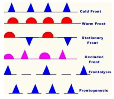
Stationary Front
- A stationary front occurs when the boundary between two air masses remains stationary, meaning that neither air mass can push against the other, resulting in a standstill.
- This happens when the wind movement on both sides of the front runs parallel to the front itself. Such a front is called a stationary front because the warm or cold front ceases to move.
- Once the boundary starts moving again, it will be classified as either a warm front or a cold front, depending on the air mass dynamics.
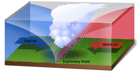
Weather along a stationary front
- Cumulonimbus clouds are created when warm air rises and cools, leading to the formation of these large, towering clouds. When warm air flows over a colder air mass along a weather front, it results in frontal precipitation, which is a common weather phenomenon.
- When cyclones move along a stationary front, they can cause heavy rainfall, leading to significant flooding in the areas near the front. This can be a serious issue, especially if the front remains stationary for an extended period, allowing the cyclone to continuously produce heavy rainfall.
Cold Front
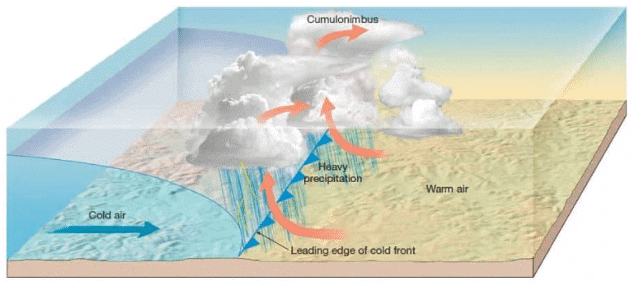
- A cold front occurs when a cold air mass overtakes and replaces a warm air mass, either by advancing into it or causing the warm air mass to retreat. In this scenario, the cold air mass is the dominant force, and the boundary between the two air masses is known as the cold front.
- Cold fronts tend to move at a faster pace than warm fronts, sometimes advancing at twice the speed. The process of frontolysis, which is the dissipation of the frontal boundary, starts when the warm air mass is entirely lifted away by the cold air mass.
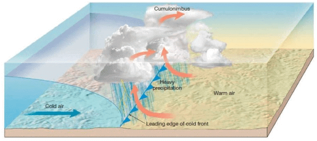
Weather along a cold front
- The weather along such a front depends on a narrow band of cloudiness and precipitation.
- Severe storms can occur. During the summer months thunderstorms are common in warm sector.
- In some regions like USA tornadoes occur in warm sector.
- Produce sharper changes in weather. Temperatures can drop more than 15 degrees within the first hour.
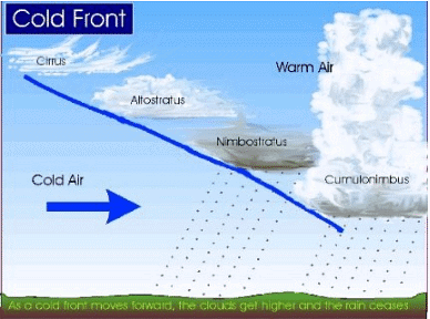
Cloud formation along a cold front
- The approach of a cold front is marked by increased wind activity in warm sector and the appearance of cirrus clouds, followed by lower, denser altocumulous and
- At actual front, dark nimbus and cumulonimbus clouds cause heavy showers. A cold front passes off rapidly, but the weather along it is violent.
Warm Front
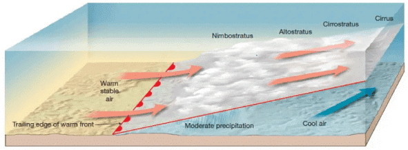
- It is a sloping frontal surface along which active movement of warm air over cold air takes place (warm air mass is too weak to beat the cold air mass).
- Frontolysis (front dissipation) begin when the warm air mass makes way for cold air mass on the ground, i.e. when the warm air mass completely sits over the cold air mass.
Weather along a warm front
- As the warm air moves up the slope, it condenses and causes precipitation but, unlike a cold front, the temperature and wind direction changes are gradual.
- Such fronts cause moderate to gentle precipitation over a large area, over several hours.
- The passage of warm front is marked by rise in temperature, pressure and change in weather.
Clouds along a warm front
- With the approach, the hierarchy of clouds is—-cirrus, stratus and nimbus. [No cumulonimbus clouds as the gradient is gentle]
- Cirrostratus clouds ahead of the warm front create a halo around sun and moon.
Occluded Front
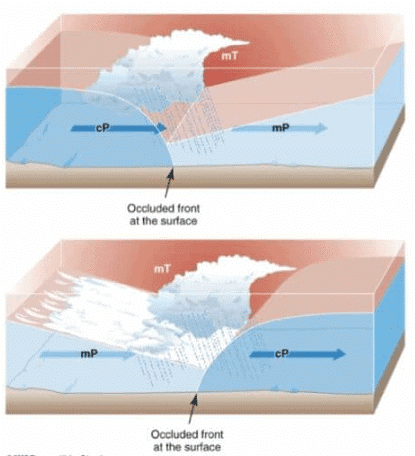
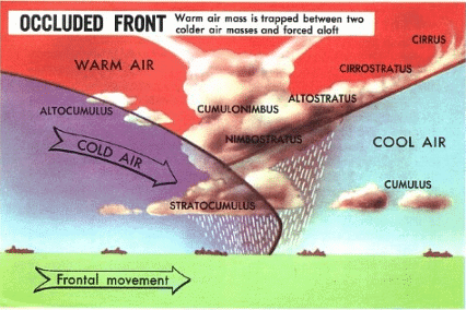
- Occlusion in meteorology refers to a phenomenon where the cold front of a rotating low-pressure system catches up to the warm front, causing the warm air between them to be pushed upwards. This occurs when a cold air mass moves faster than a warm air mass and slides beneath it.
- As the warm sector decreases in size, the cold air mass eventually takes over the entire warm sector at ground level, leading to the process known as frontolysis. Consequently, an elongated and backward-swinging occluded front is formed, which can be classified as either a warm front type or cold front type occlusion.
Weather along an occluded front
- Weather along an occluded front is complex—a mixture of cold front type and warm front type weather. Such fronts are common in west Europe.
- The formation Mid-latitude cyclones [temperate cyclones or extra-tropical cyclones] involve the formation of occluded front.
Clouds along an occluded front
- A combination of clouds formed at cold front and warm front.
- Warm front clouds and cold front clouds are on opposite side of the occlusion.
Air Masses, Fronts, and Major Atmospheric Disturbances
- Atmospheric disturbances, which can cause both stormy and calm weather conditions, play a significant role in the Earth's general circulation. These disturbances share some common characteristics: they are smaller than the components of the general circulation, migratory, relatively short-lived, and produce relatively predictable weather conditions.
- There are several types of atmospheric disturbances, with the most important ones occurring in the midlatitudes and the tropics. In the midlatitudes, where polar and tropical air masses meet and most fronts occur, weather is very dynamic and changeable. The two most significant disturbances in this region are midlatitude cyclones and midlatitude anticyclones, which greatly impact the weather due to their size and frequency.
- In the tropics, weather is generally consistent and repetitive, with only occasional disturbances. The most significant of these tropical disturbances are tropical cyclones, also known as hurricanes when they intensify. Additionally, there are less dramatic disturbances called easterly waves that also occur in the tropics
- Localized severe weather, such as thunderstorms and tornadoes, can occur in various parts of the world. These short-lived and sometimes intense disturbances often develop in conjunction with other types of storms. Overall, understanding these atmospheric disturbances is crucial for predicting and managing weather patterns and their impacts on our daily lives.
Conclusion
Air masses and fronts play a critical role in shaping global weather patterns and atmospheric disturbances. Forming over homogeneous surfaces, air masses acquire specific temperature and humidity characteristics, which influence various weather phenomena when they interact with other air masses. Fronts, as boundaries between different air masses, are crucial in the formation of mid-latitude cyclones, storms, and other meteorological events. Understanding the dynamics of air masses, fronts, and atmospheric disturbances is essential for accurate weather prediction and preparedness, ultimately impacting various aspects of human life and the environment.Frequently Asked Questions (FAQs) of Air Masses and Fronts
What is an air mass and why is it important in understanding weather patterns?
An air mass is a large body of air that has acquired specific characteristics in terms of temperature and humidity due to remaining over a homogeneous area for an extended period of time. Air masses play a crucial role in the global planetary wind system and are typically associated with specific wind belts. Understanding air masses helps us predict and manage weather patterns and their impacts on our daily lives.
What are the primary source regions for air masses?
The primary source regions for air masses are located in the subtropical high-pressure belts, which give rise to tropical air masses, and around the poles, which serve as the source for polar air masses.
What is a front in meteorology, and why is it significant?
A front is a three-dimensional boundary zone that develops between two converging air masses with varying physical properties, such as temperature, humidity, and density. Fronts typically occur in midlatitude regions and are less common in tropical and polar areas. Fronts are significant because they influence factors such as temperature distribution, moisture content, and atmospheric stability, which all play a role in determining the weather associated with these meteorological phenomena.
How are fronts classified, and what are some examples?
Fronts are classified based on the mechanism of frontogenesis (front formation) and the associated weather. Some examples of fronts include stationary fronts, cold fronts, warm fronts, and occluded fronts. Each type of front has specific characteristics and weather conditions associated with it.
What are the main types of atmospheric disturbances, and how do they affect weather?
The main types of atmospheric disturbances include midlatitude cyclones and anticyclones, tropical cyclones (also known as hurricanes), and localized severe weather such as thunderstorms and tornadoes. These disturbances can cause both stormy and calm weather conditions and play a significant role in the Earth's general circulation. Understanding these atmospheric disturbances is essential for predicting and managing weather patterns and their impacts on our daily lives.
|
303 videos|636 docs|252 tests
|
FAQs on Air Masses and Fronts - Geography Optional for UPSC
| 1. What are air masses and how are they classified? |  |
| 2. What are the characteristics of fronts? |  |
| 3. How do air masses, fronts, and major atmospheric disturbances interact? |  |
| 4. What are some major atmospheric disturbances that can occur due to air masses and fronts? |  |
| 5. What are some frequently asked questions about air masses and fronts? |  |


