Geography: September 2022 Current Affairs | Current Affairs & Hindu Analysis: Daily, Weekly & Monthly - UPSC PDF Download
| Table of contents |

|
| Triple Dip La Ninã |

|
| Thamirabarani River |

|
| Zombie ICE |

|
| Impact of Climate Change on Indian Monsoon |

|
| Advanced Dvorak Technique (ADT) |

|
Triple Dip La Ninã
In Context
Recently various weather agencies like WMO and UN predicted a rare 'triple-dip' La Nina in 2022.
More about the news
- World Meteorological Organization (WMO):
- WMO recently predicted that La Niña conditions, which involve a large-scale cooling of ocean surface temperatures, have strengthened in the eastern and central equatorial Pacific with an increase in trade winds.
- Experts say we have a high chance of experiencing our third La Niña year in a row, the first time since the year 2000.
- UN weather agency:
- The agency is also predicting that the phenomenon known as La Niña is poised to last through the end of this year.
- Challenges ahead:
- It means three straight years of La Nina effect on climate patterns like drought and flooding worldwide.
- Its cooling influence is temporarily slowing the rise in global temperatures, but it will not halt or reverse the long-term warming trend.
La Nina & ENSO
- About:
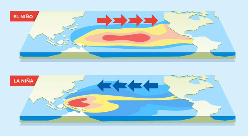
- La Niña is a natural and cyclical cooling of parts of the equatorial Pacific that changes weather patterns worldwide, as opposed to warming caused by the better-known El Niño, an opposite phenomenon.
- La Niña and trade winds:
- Due to the cooler temperature, the trade winds above the sea surface change in character because of a difference in the wind pressures.
- This change in the character of the trade winds is then carried all around the world affecting different regions in different ways.
- El Niño Southern Oscillation (ENSO):
- Together El Niño, La Niña and the neutral condition are called ENSO, which stands for El Niño Southern Oscillation.
- These oscillations have one of the largest natural effects on climate.
- Outcomes of La Nina:
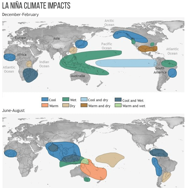
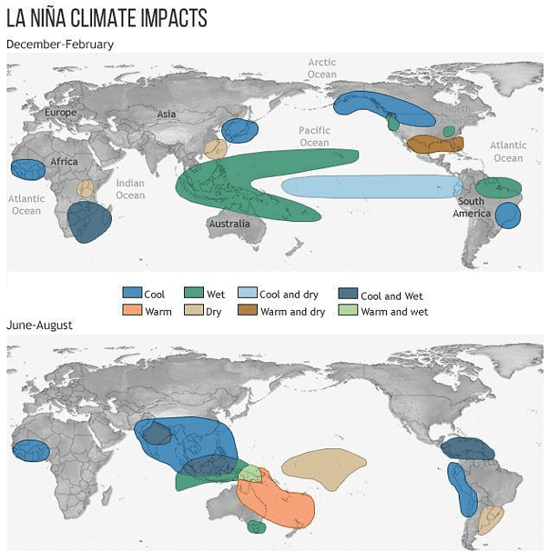
- Many regions become colder and wetter, while many others become hotter and drier.
- Causes of prolonged La Nina:
- Human-induced climate change amplifies the impacts of naturally occurring events like La Niña and is increasingly influencing our weather patterns.
- Extreme El Niño and La Niña events may increase in frequency from about one every 20 years to one every 10 years by the end of the 21st century under aggressive greenhouse gas emission scenarios.
Concerns
- For India
- No spring season for India:
- La Nina usually brings wet and cold winter and spring seasons for India, but this time large parts of India do not experience a spring season at all.
- This happens as a north-south pressure pattern, which usually forms over India during the winter season and dissipates by spring, continuing into March and April during La Niña years.
- Prolonged monsoons and floods in India:
- India can experience a prolonged monsoon season for the third year in a row.
- The monsoon seasons of 2020 and 2021 were also extended, leading to an increase in extreme rainfall events during the period.
- It may lead to subsequent floods as seen in many states in the last two years.
- India can experience a prolonged monsoon season for the third year in a row.
- No spring season for India:
- In the other parts of the world
- Drought conditions:
- The ongoing drought conditions in 40 percent of the United States, the years-long drought conditions in the Horn of Africa and southern South America would also likely continue and become more intense due to the continuation of the La Nina.
- It also leads to agricultural losses in this part of the world.
- The ongoing drought conditions in 40 percent of the United States, the years-long drought conditions in the Horn of Africa and southern South America would also likely continue and become more intense due to the continuation of the La Nina.
- Hurricanes:
- It could also form an above-average hurricane season for the Atlantic Ocean, with a 65 percent probability.
- Heat waves & wildfires:
- This condition could lead to devastating and unpredictable consequences for India and many other regions around the world in particular through more intense heat waves and drought and the associated risk of wildfires.
- Drought conditions:
Way Ahead
- Mitigation
- The current atmospheric carbon dioxide (CO2) concentrations are higher than at any time in the last two million years.
- To align with a 1.5°C target of limiting warming, global CO2 emissions must reach net zero around 2050, with global GHG emissions reaching net-zero 15-20 years later.
- A delay of 15-20 years in either net-zero CO2 or net-zero GHGs implies limiting warming to 2°C rather than 1.5°C.
- Need to shift from the sensational to the strategic
- In order to stabilise the rise in temperatures, two things have to happen:
- Anthropogenic emissions must become net-zero and,
- In the interim, cumulative emissions cannot exceed a global carbon budget.
- Adaptation
- Adaptation can be understood as the process of adjusting to the current and future effects of climate change.
- India has a strategy to combat climate change under the National Action Plan on Climate Change formed with the integration of similar missions at the state level.
- Apart from that, India has also launched the Coalition for Disaster Resilient Infrastructure (CDRI).
- However, climate change would require international collective action for maximum impact.
- This is because safeguarding the climate is a global requirement and any strategy in silos will only have a limited impact.
To read more information on this topic:
Thamirabarani River
Why in News?
The district administration of Tirunelveli in Tamil Nadu along with Ashoka Trust for Research in Ecology and the Environment (ATREE), a non-profit Organisation, are using a ‘hyper local’ approach called TamiraSES to restore the Thamirabarani River.
What is the Project About?
- Need
- The Thamirabarani is of great importance to southern Tamil Nadu environmentally and historically. But it too has suffered, which is why the restoration project has been started.
- While the Thamirabarani landscape, in general, appears water-rich, it faced severe drought in 2016 despite the diverse water storage systems in place.
- Settlements have been on the rise, which has led to the shrinkage of agricultural land and water bodies.
- TamiraSES project
- It is a district level initiative, which aims to restore the Social Ecological Systems of Tamiraparani river riverscape from head-waters to the estuary to enable conditions for native biodiversity to thrive and maintain and enhance multiple ecosystem services to local stakeholders.
- Five social ecological observatories will be set up as part of the first phase of the project. These will serve as pilots to scale up from the learnings from these sites.
- The idea is to rejuvenate not just the Thamirabarani but all the water bodies in the riverscape of Tirunelveli.
What are the Key Points of Thamirabarani River?
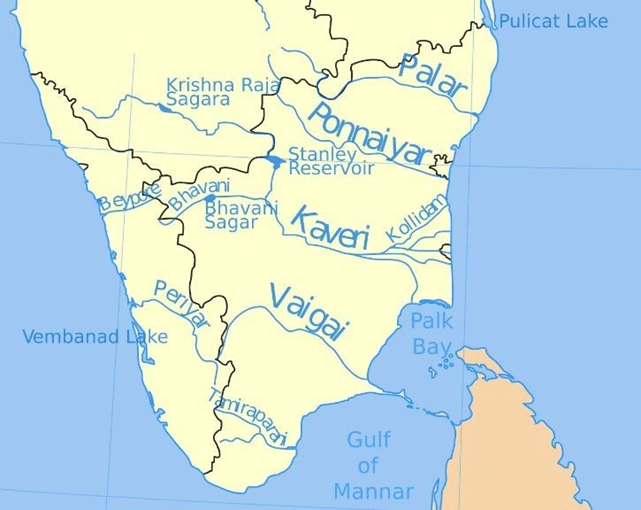
- The Thamiraparani is the only perennial (continuous flow of water) river in Tamil Nadu.
- This is the shortest river in the state, the Thamirabarani starts in Pothigai hills of the Western Ghats in the Ambasamudram taluk, flows through Tirunelveli and Thoothukudi districts and empties at Korkai into the Gulf of Mannar (Bay of Bengal). It thus originates and ends in the same state.
- The river supports wildlife such as the Nilgiri marten, slender loris, lion-tailed macaque, white spotted bush frog, galaxy frog, Sri Lankan Atlas moth and the great hornbill.
- Besides the ecosystem services it provides, the river also has historical value for the people of the state. It is mentioned extensively in Sangam Era literature.
To read more information about drainage system of India
Zombie ICE
In News
- Recently, the Scientists predicted that the melting of Zombie Ice will raise global sea level by 10 inches.
About Zombie Ice
- Background
- The vast majority of Greenland has been covered by an ice sheet for 18 million years due to being largely located within the Arctic Circle.
- Raising the global sea levels
- The melting of the Greenland ice sheet will inevitably raise the global sea levels by at least 10.6 inches or 27 centimetres.
- This is because of zombie ice which is certain to melt away from the ice cap and blend into the ocean.
- The melting of the Greenland ice sheet will inevitably raise the global sea levels by at least 10.6 inches or 27 centimetres.
- What is ‘zombie ice’?
- It is also referred to as dead or doomed ice.
- Zombie ice is one that is not accumulating fresh snow even while continuing to be part of the parent ice sheet.
- Such ice is committed to melting away and increasing sea levels.
- What has led to this?
- This is on account of warming that has already happened.
- The research points to an equilibrium state where snowfall from the higher reaches of the Greenland ice cap flows down to recharge edges of the glaciers and thicken them.
- What happens next?
- The scientists have projected that 3.3% of Greenland’s total ice volume will melt and this will happen even if the global temperature is stabilized at the current level.
- What does a rise in sea-level mean?
- It is bad news for millions that live in coastal zones. 8 of the world’s 10 largest cities are near the coast.
- Low lying coastal areas will take a harder hit.
- Rising sea levels will make flooding, high tides and storms more frequent and worse as their impact will reach more inland.
- It is a threat to local economies and infrastructure.
- The World Economic Forum’s 2019 Global Risks Report noted that already an estimated 800 million people in more than 570 coastal cities are vulnerable to a sea-level rise of 0.5 metres by 2050.
- According to the Intergovernmental Panel on Climate Change assessment, sea levels would rise by two to five inches by 2100 as a result of the Greenland glacier melting.
- It is bad news for millions that live in coastal zones. 8 of the world’s 10 largest cities are near the coast.
Impact of Climate Change on Indian Monsoon
In Context
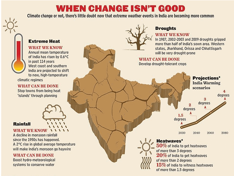
- Monsoon in India has undergone several changes over the recent years, especially on account of climate change.
More about the news
- The Indian Meteorological Department (IMD) has sighted that 2022 has seen the second highest extreme events since 1902.
- Persistence of intense La Nina conditions,
- The abnormal warming of East Indian Ocean,
- Negative Indian Ocean Dipole (IOD),
- Southward movement of most of the monsoon depressions and lows and
- Pre-monsoon heating over the Himalayan region are melting glaciers.
- This is a very complex mix.
- Recent research indicates that monsoon rainfall became less frequent but more intense in India during the latter half of the 20th century.
Indian Monsoon
- The monsoons are experienced in the tropical area roughly between 20° N and 20° S. Following are a few reasons for the formation of monsoons in the Indian Subcontinent:
- The differential heating and cooling of land (Indian subcontinent) and water (Ocean around subcontinent).
- The shift of the position of the Inter-Tropical Convergence Zone (ITCZ) in summer.
- The Inter Tropical Convergence Zone (ITCZ,) is a broad trough of low pressure in equatorial latitudes. This is where the northeast and the southeast trade winds converge. This convergence zone lies more or less parallel to the equator but moves north or south with the apparent movement of the sun
- The presence of the high-pressure area, east of Madagascar over the Indian Ocean.
- The Tibetan plateau gets intensely heated during summer, which results in strong vertical air currents.
- The movement of the westerly jet stream to the north of the Himalayas and the presence of the tropical easterly jet stream over the Indian peninsula during summer.
Effects of Monsoon on Indian Subcontinent
- The Indian landscape, it's animal and plant life, its entire agricultural calendar and the life of the people, including their festivities, revolve around this phenomenon.
- Agriculture:
- It accounts for 18 percent of India’s growth domestic product (GDP) and employs around half of its total workforce. The monsoon rains are the main source of water for 55 percent of the country’s arable land. This means the rains are crucial — not only for India’s farmers but for its economy as a whole.
- Rivers
- The monsoon brings water and sediment not only to Indian rivers but also to rivers in China, Bangladesh, etc.
- Festivals
- There are numerous traditional fasts and festivals celebrated during the wet season, some of them are Ganga Dussehra, Rath Yatras, Kanwarias, Janmashtami, Barsha Mongol Ramadan and Splash fairs are one of the most important parts of all monsoon festivals.
Impact of Climate Change on monsoon
- Overall
- A shift in the track of monsoon systems, like low pressure and depression travelling south of their position and flash floods are a result of this change.
- And these changes spell intense and frequent extreme unprecedented weather events over the places which once struggled to record even normal monsoon rains.
- Shift of monsoon weather systems
- Usually, monsoon systems move across Northwest India giving rains over the region there.
- But this year most of the monsoon weather systems have been travelling across central parts of the country, changing the area of rainfall.
- As a result, States such as Madhya Pradesh, Gujarat, Rajasthan and parts of Maharashtra have been recording excess rainfall this season.
- West Bengal, Jharkhand, Bihar and Uttar Pradesh are experiencing the worst monsoon season of the century.
- Experts believe that these changes are here to stay, which would continue to propel extreme weather events over the entire South Asian region.
- Worldwide implications
- During the last six months, entire South Asia has been reporting a series of extreme weather events.
- While Bangladesh, India and Pakistan have battled severe floods, China is reeling under massive drought conditions.
- Rice production
- One of the major impacts of changes in track of monsoon systems can be seen on kharif crops, particularly rice production.
- They form a significant share of more than 50% of total food grain production during this period.
- The state experiencing monsoon deficit, West Bengal, Bihar, Jharkhand and east Uttar Pradesh are all rice-producing states.
- One of the major impacts of changes in track of monsoon systems can be seen on kharif crops, particularly rice production.
- Overall impacts on crops
- These uneven distribution rains along with increasing temperatures and humidity give rise to pest attacks and diseases.
- This will, in turn, impact the quality of the grain as well as the nutrition value may vary.
- According to a study, ‘Climate change, the monsoon, and rice yield in India’, very high temperatures (> 35°C) induce heat stress and affect plant physiological processes, leading to spikelet sterility, non-viable pollen and reduced grain quality.
- Drought, on the other hand, reduces plant transpiration rates and may result in leaf rolling and drying, reduction in leaf expansion rates and plant biomass, immobilisation of solutes and increased heat stress of leaves.
- These uneven distribution rains along with increasing temperatures and humidity give rise to pest attacks and diseases.
Way Ahead
- Slow onsets can still be taken care of through adaptation and resilience ideas but these kinds of big events are very difficult to cope with.
- That is where the main issue lies as the country would then have to divert development money to climate finance to combat climate change.
- India’s hundreds of millions of rice producers and consumers are being affected negatively with these unprecedented changes which are also raising concerns over food security.
- Short-term actions & solutions:
- In UP, the Agriculture Meteorology division has advised carrying out the transplantation of rice and suggested the use of short-duration rice varieties.
- Experts have encouraged the cultivation of red gram.
- Farmers are also recommended to opt for inter-cropping.
- For farmers in Jharkhand, the Agrimet has suggested adopting measures to conserve moisture in the soil.
- No sowing is advised until there is 50 to 60mm rainfall and sufficient moisture for at least three consecutive days.
- Short-duration rice, millet, maize, and arha
- In UP, the Agriculture Meteorology division has advised carrying out the transplantation of rice and suggested the use of short-duration rice varieties.
- Short-term actions & solutions:
To read more information:
Advanced Dvorak Technique (ADT)
Why in News?
Recently, the American meteorologist Vernon Dvorak passed away, on whom Dvorak Technique was named to forecast Weather.
- Dvorak was an American meteorologist best credited for developing the Dvorak (read as Do-rak) technique in the early 1970s.
What is the Dvorak technique?
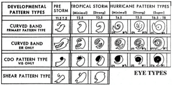
- The Dvorak technique is a Cloud Pattern Recognition Technique (CPRT) based on a concept model of the development and decay of the tropical cyclone.
- It was first developed in 1969 and tested for observing storms in the northwest Pacific Ocean.
- In this methodology, available satellite images obtained from polar orbiting satellites are used to examine the features of the developing tropical storms (hurricanes, cyclones and typhoons).
- During day time, images in the visible spectrum are used while at night, the ocean is observed using infrared images.
- From the satellite images the technique helps forecasters do a pattern recognition from the observed structure of the storm, locate its eye and estimate the intensity of the storm.
- Although it cannot help make any predictions, measure wind or pressure or any other meteorological parameters associated with the cyclone, it is a guide to estimate the storm’s intensity and possible intensification — which is crucial for local administration in planning evacuation measures of coastal or other nearby residents.
Why is Technique still Widely in Use?
- Even having an improved network of land-based meteorological observations, ocean observations still remain limited.
- There are many regions across the four oceans that have not been fully examined with meteorological instruments.
- Ocean observations are mostly taken by deploying buoys or dedicated ships, but the number of observations from the seas is still not sufficient across the world.
- That is why meteorologists have had to depend more on satellite-based imageries, and combine it with the available ocean-data at the time of forecasting the intensity and wind speed of the tropical cyclones.
- The Dvorak technique has undergone several advancements since its inception. Even in the present day, when forecasters have access to several state-of-the-art tools like model guidance, animations, artificial intelligence, machine learning and satellite technology, it is the advanced versions of the Dvorak technique that continues to be widely used.
|
38 videos|5288 docs|1117 tests
|
FAQs on Geography: September 2022 Current Affairs - Current Affairs & Hindu Analysis: Daily, Weekly & Monthly - UPSC
| 1. What is Triple Dip La Niña? |  |
| 2. What is the Thamirabarani River? |  |
| 3. What is Zombie ICE? |  |
| 4. What is the impact of climate change on the Indian monsoon? |  |
| 5. What is the Advanced Dvorak Technique (ADT) in geography? |  |


