Geography: February 2023 UPSC Current Affairs | Current Affairs & Hindu Analysis: Daily, Weekly & Monthly PDF Download
| Table of contents |

|
| Earthquakes in Turkey and Causes |

|
| India’s Earthquake Preparedness |

|
| GSI Discovers Lithium Resources in J&K |

|
| Groundwater Loss for the Indian Ganga Basin |

|
Earthquakes in Turkey and Causes
Context
- Recently, three earthquakes measuring 7.8, 7.6, and 6.0 magnitude on the Richter scale hit wide swaths of Turkey and neighbouring Syria.
More about the news
Epicentre
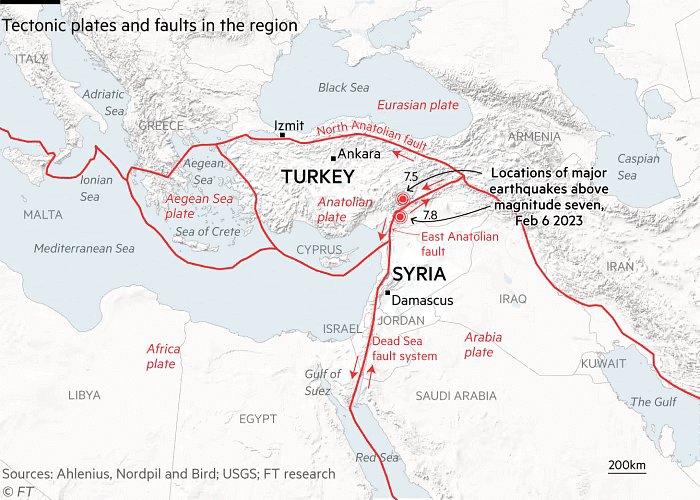
- The epicentre was about 26 km east of the Turkish city of Nurdagi at a depth of about 18 km on the East Anatolian Fault.
- The quake radiated towards the northeast, bringing devastation to central Turkey and Syria.
Damage
- This is the strongest earthquake to shake the region in more than 100 years.
- It has killed at least 3,800 people across Turkey and Syria.
Vulnerability of the region
- The area has many buildings constructed of brittle concrete (which makes them prone to cracking, spalling, loss of strength, or steel corrosion), making them “extremely vulnerable to earthquake shaking.
Earthquake
- It is the shaking of the surface of the Earth which results in a sudden release of energy in the Earth’s lithosphere (rocky outer part of the Earth) that creates seismic waves.
- Earthquakes can cause severe damage, particularly in an area where homes and other buildings are poorly constructed and landslides are common.
- An earthquake’s point of initial rupture is called its hypocenter or focus.
- The epicentre is the point at ground level directly above the hypocenter.
- It is measured in the Richter scale.
Plate Tectonic Theory/Plate Tectonic
- Plate tectonic theory had its beginnings in 1915 when Alfred Wegener proposed his theory of "continental drift.
- According to the Plate Tectonic theory, Earth has a rigid outer layer, known as the lithosphere, which is typically about 100 km (60 miles) thick and overlies a plastic (moldable, partially molten) layer called the asthenosphere.
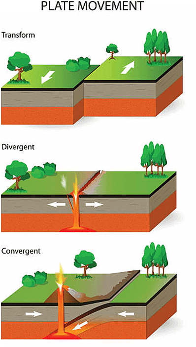
- The lithosphere is broken up into:
- seven very large continental- and ocean-sized plates, six or seven medium-sized regional plates, and several small plates.
- These plates move relative to each other.
- They typically move at rates of 5 to 10 cm (2 to 4 inches) per year, and interact along their boundaries.
- They converge, diverge, or slip past one another.
 Outcomes
- Responsible for Earthquakes: Such interactions are thought to be responsible for most of Earth’s seismic and volcanic activity, although earthquakes and volcanoes can occur in plate interiors.
- Mountain formation: Plate motions cause mountains to rise where plates push together or converge.
- Ocean formation: Continents fracture and oceans are formed where plates pull apart or diverge.
Reasons of Turkey’s Earthquakes
- Turkey’s proneness to earthquakes:
- Turkey is frequently shaken by earthquakes.
- In 2020 itself, it recorded almost 33,000 earthquakes in the region, according to Disaster and Emergency Management Authority (AFAD).
- Out of these, 332 earthquakes were of magnitudes 4.0 and higher.
- Turkey’s proneness to earthquakes comes from its tectonic location.
- According to one estimate, almost 95% of the country’s land mass is prone to earthquake.
- About a third of the country is at high risk, including the areas around the major cities of Istanbul and Izmir and the region of East Anatolia.
Significance of location
- Anatolian tectonic plate:
- Turkey is located on the Anatolian tectonic plate, which is wedged between the Eurasian and African plates.
- On the north side, the minor Arabian plate further restricts movement.
- North Anatolian fault (NAF) line:
- One fault line — the North Anatolian fault (NAF) line, the meeting point of the Eurasian and Anatolian tectonic plates — is known to be “particularly devastating”.
- The NAF, one of the best-understood fault systems in the world, stretches from the south of Istanbul to northeastern Turkey, and has caused catastrophic earthquakes in the past.
- East Anatolian fault line:
- Then there is the East Anatolian fault line, the tectonic boundary between the Anatolian Plate and the northward-moving Arabian Plate.
- It runs 650 kilometers from eastern Turkey and into the Mediterranean.
- Aegean Sea Plate:
- In addition to this, the Aegean Sea Plate, located in the eastern Mediterranean Sea under southern Greece and western Turkey, is also a source of seismic activity in the region.
Damage to the ancient historical sites
- Gaziantep Kalesi:
- The historic 2,200-year-old stone castle sitting atop a hill in the centre of Gaziantep.
- Known locally as Gaziantep Kalesi, the historic stone castle was first constructed as an observation point by the Hittite Empire during the second millennium BC.
- For over 2,000 years, Gaziantep Castle stood strong, its structure remaining intact despite waves of invasion and conquest that saw it controlled by a series of Middle Eastern empires.
- It is the most famous landmark of Gaziantep which was used as an observation point during Roman times – has been damaged, with its walls and watch towers disintegrated.
- Yeni Mosque:
- One of the most prominent sites in Maltaya, the famous Yeni Mosque which dates back to the 13th century, has collapsed due to the earthquake.
India’s Earthquake Preparedness
Why in News?
A severe earthquake followed by an almost equal magnitude aftershock hit southeastern Turkey and Syria on February 6, 2023, causing widespread destruction and loss of life.
- The Turkey-Syria earthquake should motivate a review of India’s earthquake preparedness, as poor enforcement of zoning and construction rules is prevalent in the country.
What Makes India Susceptible to Earthquakes?
About:
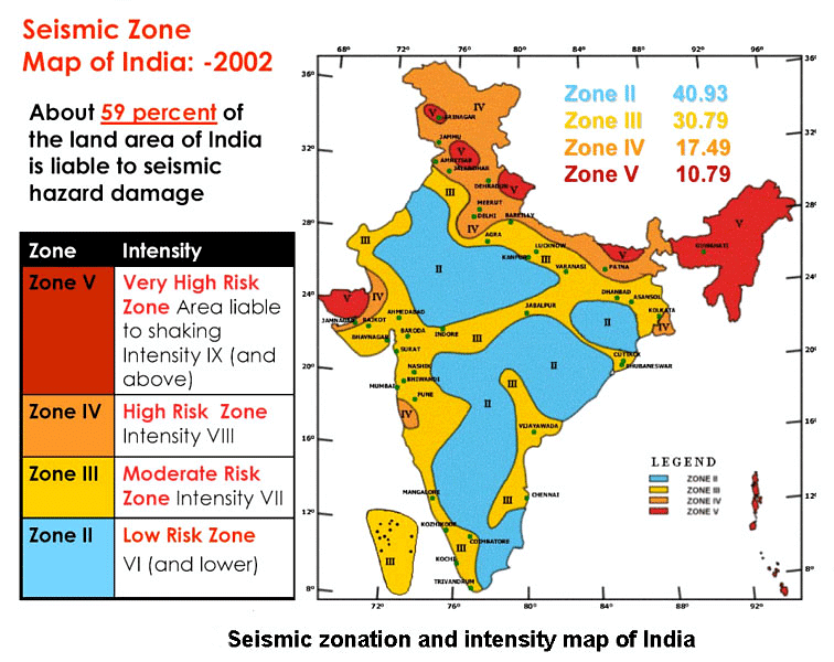
India’s terrain is prone to great earthquakes, particularly in the Himalayan plate boundary, which has the potential for large quakes (magnitude 7 and above).
- In India, earthquakes are primarily caused by the collision of the Indian Plate with the Eurasian Plate.
- This collision has resulted in the formation of the Himalayas, as well as frequent earthquakes in the region.
Seismic Zones
Susceptibility of Major Earthquakes
- Scientists are aware of identifiable seismic gaps along the Himalayan axis where the historical release of geological tension doesn’t fully account for the strain that has built up.
- For instance, the Central Himalaya has been historically deficient in earthquakes compared to other areas. So, it’s one region that can reasonably be expected to generate a large earthquake in the future.
Earthquakes In/Around India
India has experienced several significant earthquakes over the years, here are some examples: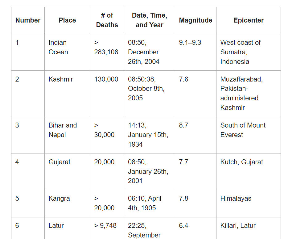
- Nepal Earthquake 2015: On April 25, 2015, a magnitude 7.8 earthquake struck Nepal. The earthquake also had a significant impact in northern India.
- Imphal Earthquake 2016: On January 4, 2016, a magnitude 6.7 earthquake struck the northeastern Indian state of Manipur, causing widespread damage.
- Uttarakhand Earthquake 2017: On February 6, 2017, a magnitude 6.7 earthquake struck the northern Indian state of Uttarakhand.
What Steps can be Taken for Earthquake Preparedness in India?
Building Codes and Standards: India has established building codes and standards for earthquake-resistant construction.
- It is important to strictly enforce these codes and standards to ensure that new buildings are built to withstand earthquakes. This will also require regular inspections and enforcement of existing building codes.
- Retrofitting and Reinforcement: Older buildings may not meet current earthquake-resistant standards, and many of them can be retrofitted or reinforced to improve their seismic performance.
- Emergency Response Planning: Planning for emergency response is critical for minimising the impact of earthquakes. This includes developing evacuation plans, establishing emergency shelters, and training personnel on how to respond to earthquakes.
- Research and Monitoring: Investing in research and monitoring can help improve our understanding of earthquakes and their causes, and can also help to develop better methods for predicting and mitigating their impact.
- Land-Use Planning: It is important to consider the potential impacts of earthquakes when planning and developing land-use policies. This includes limiting development in areas that are prone to earthquakes and ensuring that new development is designed and constructed in a way that minimises the risk of damage.
GSI Discovers Lithium Resources in J&K
Why in News?
The Geological Survey of India has for the first-time established Lithium ‘inferred’ resources(G3) of 5.9 million tonnes in Salal-Haimana area of the UT of Jammu & Kashmir.
What are Inferred Resources?
- The “inferred” mineral resource is a resource for which quantity, grade and mineral content are estimated only with a low level of confidence.
- It is based on information gathered from locations such as outcrops, trenches, pits, workings and drill holes that may be of limited or uncertain quality, and also of lower reliability from geological evidence.
- It is based on the classification from United Nations International Framework Classification for Reserves/Resources – Solid Fuels and Mineral Commodities of 1997 (UNFC-1997).
What is UNFC-1997?
- UNFC-1997 is a system for the classification and reporting of reserves and resources of solid fuels and mineral commodities and provides a standardized, internationally recognized system for the reporting of reserves and resources.
- It has been developed by the UN Economic Commission for Europe.
- It promotes transparency and consistency in the reporting of mineral and energy assets and ensures that geological, engineering, and economic information is used consistently.
- It provides a basis for comparing reserves and resources data between countries and regions which is widely used by governments, industry, and financial institutions around the world.
- According to UNFC-1997, there are four stages of exploration for any mineral deposit:
- Reconnaissance (G4)
- Preliminary exploration (G3)
- General Exploration (G2)
- Detailed Exploration (G1)
What is Lithium?
About:
- Lithium (Li), sometimes also referred as ‘White gold’ due to its high demand for rechargeable batteries, is a soft and silvery-white metal.
Extraction:
- Lithium can be extracted in different ways, depending on the type of the deposit — generally either through solar evaporation of large brine pools, or from hard-rock extraction of the ore.
Uses:
- Lithium is an important component of electrochemical cells used in batteries of EVs, Laptops, Mobiles etc.
- It is also used in thermonuclear reactions.
- It is used to make alloys with aluminium and magnesium, improving their strength and making them lighter.
- Magnesium-lithium alloy - for armour plating.
- Aluminum-lithium alloys - in aircraft, bicycle frames and high-speed trains.
Major Global Lithium Reserves:
- Chile > Australia > Argentina are top countries with Li reserves.
- Lithium Triangle: Chile, Argentina, Bolivia.
Lithium Reserves in India:
- Preliminary survey showed estimated lithium reserves of 14,100 tonnes in a small patch of land surveyed in Southern Karnataka’s Mandya district.
- Other potential sites:
- Mica belts in Rajasthan, Bihar, Andhra Pradesh.
- Pegmatite belts in Odisha and Chhattisgarh.
- Rann of Kutch in Gujrat.
How India Currently Fulfills its Lithium Demand?
- India is currently dependent on imports for lithium cells and batteries. Over 165 crore lithium batteries are estimated to have been imported into India between FY17 and FY20 at an estimated import bill of upwards of $3.3 billion.
- The country's efforts to secure lithium sourcing agreements are seen as a move against imports from China, which is the major source of both raw materials and cells.
- India is perceived as a late entrant into the lithium value chain, entering at a time when the EV sector is expected to undergo significant disruption.
- 2023 is considered a turning point for battery technology, with the potential for several improvements to the Li-ion technology.
What is the Significance of Discovery?
Assistance in Achieving Targets:
- India has pledged to reduce its emissions towards net zero by 2070, which requires the availability of lithium as a critical component in electric vehicle (EV) batteries.
- The Central Electricity Authority of India has estimated that the country will need 27 GW of grid-scale battery energy storage systems by 2030, which will require massive amounts of lithium.
Addressing Global Shortages:
- The World Economic Forum (WEF) has warned of global lithium shortages due to rising demand for EVs and rechargeable batteries, which is estimated to reach 2 billion by 2050.
- The world's supply of lithium is under strain due to the concentration of resources in a few locations with 54% of the world's Lithium reserves are found in Argentina, Bolivia and Chile.
- The International Energy Agency (IEA) predicts that the world could face lithium shortages by 2025.
Groundwater Loss for the Indian Ganga Basin
Why in News?
A recent report, "Estimation of groundwater storage loss for the Indian Ganga Basin using multiple lines of evidence," estimates that groundwater storage levels in the Ganga basin have been declining by 2.6 centimeters per year.
- The Ganga Basin’s aquifers are one of the largest reservoirs of groundwater in the world.
What are the Findings?
- The average groundwater levels have been declining at a rate of 2.6 cm year-1 between 1996-2017.
- The analysis of satellite data from the Gravity Recovery and Climate Experiment (GRACE), yielded an average loss of 1.7 cm per year-1.
- GRACE satellites, launched in 2002, assess Earth’s water reservoirs over land, ice and ocean.
- The average storage decline in Uttar Pradesh, Bihar and West Bengal was estimated to be roughly 2 cm year−1, 1 cm year−1 and 0.6 cm year−1, respectively.
- The impacts were more pronounced in Rajasthan, Haryana and Delhi, with average storage declines of roughly 14 cm year−1, 7.5 cm year−1 and 7.2 cm year−1, respectively.
- West and southwest areas, including agriculturally intensive regions and urban areas like Delhi and Agra, took the biggest hit.
- Delhi and Haryana have high groundwater abstraction rates, which explains the steep decline.
- The Brahmaputra basin shows more groundwater level reduction than the Ganga and Indus basins.
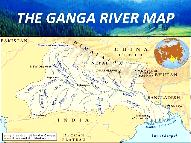
What is the Ganga River System?
- It is the longest river of India flowing over 2,510 km of mountains, valleys and plains and is revered by Hindus as the most sacred river on earth.
- The Ganga basin outspreads in India, Tibet (China), Nepal and Bangladesh over an area of 10,86,000 Sq.km.
- In India, it covers states of Uttar Pradesh, Madhya Pradesh, Rajasthan, Bihar, West Bengal, Uttarakhand, Jharkhand, Haryana, Chhattisgarh, Himachal Pradesh and Union Territory of Delhi draining nearly 26% of the total geographical area of the country.
- It originates in the snowfields of the Gangotri Glacier in the Himalayas.
- At its source, the river is called as the Bhagirathi. It descends down the valley upto Devprayag where after joining another hill stream Alaknanda, it is called Ganga.
- The principal tributaries joining the river from right are the Yamuna and the Son.
- The Ramganga, the Ghaghra, the Gandak, the Kosi and the Mahananda join the river from left. The Chambal and the Betwa are the two other important sub- tributaries.
- The Ganges River Dolphin is an endangered animal that specifically habitats this river.
- The Ganga joins the Brahmaputra (Jamuna) in Bangladesh and continues its run under the name Padma.
- The Ganga widens out into the Ganges Delta in the Sundarbans swamp of Bangladesh, before it ends its journey by emptying into the Bay of Bengal.
|
38 videos|5275 docs|1115 tests
|
FAQs on Geography: February 2023 UPSC Current Affairs - Current Affairs & Hindu Analysis: Daily, Weekly & Monthly
| 1. What are the main causes of earthquakes in Turkey? |  |
| 2. How prepared is India for earthquakes and what measures have been taken? |  |
| 3. What are the implications of groundwater loss for the Indian Ganga Basin? |  |
| 4. What is the significance of the Geological Survey of India's discovery of lithium resources in J&K? |  |
| 5. How does India's earthquake preparedness compare to other countries prone to seismic activity? |  |

