
Best Study Material for Class 5 Exam
Class 5 Exam > Class 5 Notes > Social Studies for Class 5 > Worksheet Solutions: Major Landforms - 1
Major Landforms - 1 Class 5 Worksheet SST
 Q1: True or False
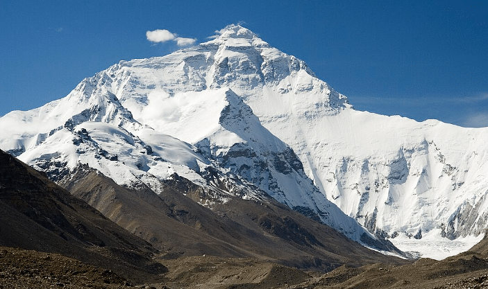
(i) Mountains are the highest landforms on Earth.
Ans: True
Mountains are natural elevations of the Earth's surface, typically rising to considerable height and often featuring peaks. They are among the highest landforms, with some like Mount Everest reaching elevations exceeding 8,000 meters above sea level.
(ii) An island is a landform surrounded by water on all sides.
Ans: True
An island is defined as a piece of land that is completely surrounded by water, distinguishing it from continents and peninsulas.
(iii) A valley is a low-lying area of land between mountains or hills.
Ans: True
A valley is typically a stretched lowland between hills or mountains, often having a river or stream running along its length. It is characterized by its lower elevation relative to the surrounding terrain.
(iv) A desert is a landform with abundant rainfall and vegetation.
Ans: False
Deserts are defined by their dry conditions, receiving very little precipitation annually. They often have sparse vegetation due to the lack of water, making this statement incorrect.
(v) A canyon is a deep, narrow valley with steep sides.
Ans: True
A canyon is a deep, narrow depression in the Earth's surface, typically with very steep sides. They are usually formed by the erosion activity of rivers over geological timescales.
(vi) A plateau is a flat, elevated landform.
Ans: True
A plateau, also known as a tableland, is a large flat-topped area that rises sharply above the surrounding area. It is often found at high altitudes.
(vii) A peninsula is a piece of land surrounded by water on three sides.
Ans: False
A peninsula is a landform that is surrounded by water on three sides but remains connected to a larger landmass on one side.
(viii) A volcano is a landform formed by the eruption of hot magma from Earth's interior.
Ans: True
A volcano is formed by the geological activity involving the ascent of magma from the Earth's mantle to the surface. When magma erupts through the crust, it builds up around the vent, creating a volcanic mountain.
(ix) A plain is a landform characterized by gentle slopes and low elevation.
Ans: True
Plains are large stretches of flat or gently undulating land that do not exhibit high elevations or steep gradients. They are often formed by sediment deposition from rivers.
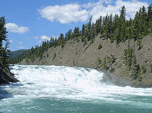
(x) A river is a flowing body of water that typically empties into an ocean or lake.
Ans: True
Rivers are natural watercourses, flowing towards larger bodies of water such as seas, oceans, or lakes. They are crucial for the drainage of land, facilitating the movement of water through hydrological cycles.
Q2: Fill in the Blanks
(i) The highest mountain in the world is __________.Ans: Mount Everest
(ii) A large body of saltwater is called a __________.
Ans: Sea or Ocean
(iii) The Great Barrier Reef is an example of a __________.
Ans: Coral Reef
(iv) The Grand Canyon is an example of a __________.
Ans: Canyon
(v) The Himalayas are an example of a __________.
Ans: Mountains
(vi) A landform that has steep sides and a flat top is called a __________.
Ans: Plateau
(vii) The Amazon River flows through the __________.
Ans: Amazon Rainforest
(viii) The Great Plains in the United States are an example of a __________.
Ans: Plain
(ix) The Sahara Desert is located in __________.
Ans: Africa
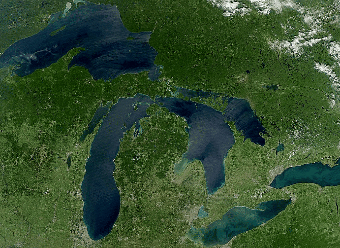
(x) The Great Lakes are a group of five __________ located in North America.
Ans: Lakes
Q3: Match the Following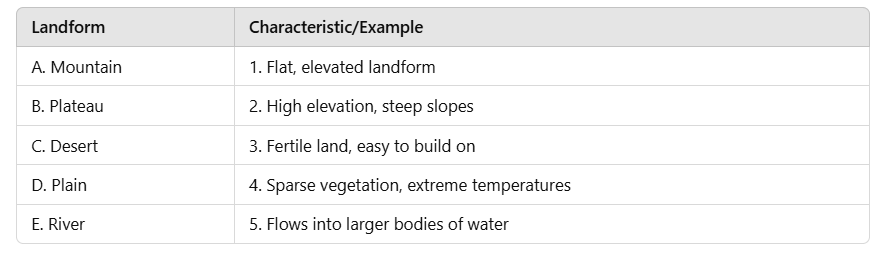
Ans:
A - 2 (Mountain - High elevation, steep slopes)
B - 1 (Plateau - Flat, elevated landform)
C - 4 (Desert - Sparse vegetation, extreme temperatures)
D - 3 (Plain - Fertile land, easy to build on)
E - 5 (River - Flows into larger bodies of water)
Q4: Find the Odd One Out and Give Reason.
(i) Mountain, Plateau, Canyon, Desert
Ans: Canyon
Unlike the others which are primarily elevated or large landforms, a canyon is a deep, narrow valley with steep sides, typically carved by river erosion.
(ii) River, Lake, Ocean, Plain
Ans: Plain
Rivers, lakes, and oceans are bodies of water, whereas a plain is a large area of flat or gently rolling land.
(iii) Volcano, Peninsula, Island, Plateau
Ans: Plateau
Volcano, peninsula, and island can all be associated with formations involving water (island and peninsula surrounded by water, volcanoes often near water bodies or creating islands); a plateau is typically an elevated flat landform without direct association with water.
Q5: Short Answer Type Questions
(i) Define a volcano and explain how it is formed.
Ans: A volcano is a landform that forms when molten rock, ash, and gases escape through the Earth's crust. This molten rock, known as magma, is formed from the melting of rocks deep within the Earth. When the pressure builds up, the magma erupts through a vent or opening, creating a volcano. The erupted material, including lava, ash, and volcanic gases, can build up around the vent, forming a mountain-like structure. Volcanoes can be found on land or underwater.
(ii) Name two major types of landforms found underwater and describe them briefly.
Ans: Two major types of landforms found underwater are seamounts and ocean trenches. Seamounts are volcanic mountains that rise from the ocean floor but do not reach the surface. They can be cone-shaped or elongated and are formed by volcanic activity. Ocean trenches, on the other hand, are long, narrow depressions on the ocean floor. They are formed when two tectonic plates converge, and one plate is forced beneath the other, creating a deep trench. The Mariana Trench in the western Pacific Ocean is the deepest known trench on Earth.
(iii) What are the main characteristics of a mountain range?
Ans: Mountain ranges are characterized by a series of connected mountains. They are formed through tectonic processes, such as the collision of continental plates or the uplift caused by volcanic activity. The main characteristics of a mountain range include high elevation, steep slopes, and a series of peaks or summits. They often form natural barriers, influencing weather patterns and creating diverse ecosystems.
(iv) How are islands formed?
Ans: Islands are formed through various processes. One common way is through volcanic activity. When an underwater volcano erupts, it can build up layers of lava and ash, eventually rising above the water surface and forming an island. Another way islands are formed is through the deposition of sediment carried by rivers or ocean currents. Over time, these sediments accumulate and can create landforms that become islands.
(v) Briefly explain the process of erosion and its impact on landforms.
Ans: Erosion is the process of wearing away or breaking down landforms through the movement of water, wind, ice, or other agents. It can have a significant impact on shaping landforms over long periods. Water erosion, for example, occurs when rivers or waves remove soil and rock particles from the land, creating features like valleys and canyons. Wind erosion can carry and deposit particles, leading to the formation of sand dunes in deserts. Erosion can also contribute to the formation of caves through the dissolution of limestone by water.
The document Major Landforms - 1 Class 5 Worksheet SST is a part of the Class 5 Course Social Studies for Class 5.
All you need of Class 5 at this link: Class 5
|
32 videos|228 docs|48 tests
|


FAQs on Major Landforms - 1 Class 5 Worksheet SST
| 1. What are landforms? |  |
| 2. How are mountains formed? | |
Ans. Mountains are formed through a process called tectonic activity. When two tectonic plates collide or move apart, it can result in the formation of mountains. The collision causes the Earth's crust to buckle and fold, creating towering peaks and ridges.
| 3. What causes the formation of valleys? | |
Ans. Valleys are typically formed by the erosion of rivers and glaciers. Over time, flowing water or moving ice can carve out deep channels in the Earth's surface, resulting in the formation of valleys. Other factors, such as tectonic activity and volcanic activity, can also contribute to valley formation.
| 4. How do plateaus form? | |
Ans. Plateaus are formed by various geological processes. One common way is through the uplift of land due to tectonic activity. When the Earth's crust is uplifted, it can create a high, flat area known as a plateau. Erosion and weathering can also shape plateaus over time.
| 5. What is the difference between a hill and a mountain? | |
Ans. The main difference between a hill and a mountain is their height and steepness. A hill is generally smaller in size and has a gentler slope, while a mountain is larger and has a steeper slope. The exact definition of a hill versus a mountain can vary in different regions and cultures.
Related Exams
About this Document

4.92/5
Rating

Apr 25, 2025
Last updated
Document Description: Worksheet Solutions: Major Landforms - 1 for Class 5 2025 is part of Social Studies for Class 5 preparation.
The notes and questions for Worksheet Solutions: Major Landforms - 1 have been prepared according to the Class 5 exam syllabus. Information about Worksheet Solutions: Major Landforms - 1 covers topics
like and Worksheet Solutions: Major Landforms - 1 Example, for Class 5 2025 Exam. Find important definitions, questions, notes, meanings, examples, exercises and tests below for Worksheet Solutions: Major Landforms - 1.
Introduction of Worksheet Solutions: Major Landforms - 1 in English is available as part of our Social Studies for Class 5
for Class 5 & Worksheet Solutions: Major Landforms - 1 in Hindi for Social Studies for Class 5 course.
Download more important topics related with notes, lectures and mock test series for Class 5
Exam by signing up for free. Class 5: Major Landforms - 1 Class 5 Worksheet SST
Description
Full syllabus notes, lecture & questions for Major Landforms - 1 Class 5 Worksheet SST - Class 5 | Plus excerises question with solution to help you revise complete syllabus for Social Studies for Class 5 | Best notes, free PDF download
Information about Worksheet Solutions: Major Landforms - 1
In this doc you can find the meaning of Worksheet Solutions: Major Landforms - 1 defined & explained in the simplest way possible. Besides explaining types of
Worksheet Solutions: Major Landforms - 1 theory, EduRev gives you an ample number of questions to practice Worksheet Solutions: Major Landforms - 1 tests, examples and also practice Class 5
tests

Related Searches
ppt
,Major Landforms - 1 Class 5 Worksheet SST
,past year papers
,shortcuts and tricks
,video lectures
,Viva Questions
,Major Landforms - 1 Class 5 Worksheet SST
,MCQs
,Extra Questions
,mock tests for examination
,Objective type Questions
,Important questions
,Summary
,study material
,practice quizzes
,Sample Paper
,Previous Year Questions with Solutions
,Free
,Exam
,Major Landforms - 1 Class 5 Worksheet SST
,Semester Notes
;


Additional Information about Worksheet Solutions: Major Landforms - 1 for Class 5 Preparation
Worksheet Solutions: Major Landforms - 1 Free PDF Download
The Worksheet Solutions: Major Landforms - 1 is an invaluable resource that delves deep into the core of the Class 5 exam.
These study notes are curated by experts and cover all the essential topics and concepts, making your preparation more efficient and effective.
With the help of these notes, you can grasp complex subjects quickly, revise important points easily,
and reinforce your understanding of key concepts. The study notes are presented in a concise and easy-to-understand manner,
allowing you to optimize your learning process. Whether you're looking for best-recommended books, sample papers, study material,
or toppers' notes, this PDF has got you covered. Download the Worksheet Solutions: Major Landforms - 1 now and kickstart your journey towards success in the Class 5 exam.
Importance of Worksheet Solutions: Major Landforms - 1
The importance of Worksheet Solutions: Major Landforms - 1 cannot be overstated, especially for Class 5 aspirants.
This document holds the key to success in the Class 5 exam.
It offers a detailed understanding of the concept, providing invaluable insights into the topic.
By knowing the concepts well in advance, students can plan their preparation effectively.
Utilize this indispensable guide for a well-rounded preparation and achieve your desired results.
Worksheet Solutions: Major Landforms - 1 Notes
Worksheet Solutions: Major Landforms - 1 Notes offer in-depth insights into the specific topic to help you master it with ease.
This comprehensive document covers all aspects related to Worksheet Solutions: Major Landforms - 1.
It includes detailed information about the exam syllabus, recommended books, and study materials for a well-rounded preparation.
Practice papers and question papers enable you to assess your progress effectively.
Additionally, the paper analysis provides valuable tips for tackling the exam strategically.
Access to Toppers' notes gives you an edge in understanding complex concepts.
Whether you're a beginner or aiming for advanced proficiency, Worksheet Solutions: Major Landforms - 1 Notes on EduRev are your ultimate resource for success.
Worksheet Solutions: Major Landforms - 1 Class 5 Questions
The "Worksheet Solutions: Major Landforms - 1 Class 5 Questions" guide is a valuable resource for all aspiring students preparing for the
Class 5 exam. It focuses on providing a wide range of practice questions to help students gauge
their understanding of the exam topics. These questions cover the entire syllabus, ensuring comprehensive preparation.
The guide includes previous years' question papers for students to familiarize themselves with the exam's format and difficulty level.
Additionally, it offers subject-specific question banks, allowing students to focus on weak areas and improve their performance.
Study Worksheet Solutions: Major Landforms - 1 on the App
Students of Class 5 can study Worksheet Solutions: Major Landforms - 1 alongwith tests & analysis from the EduRev app,
which will help them while preparing for their exam. Apart from the Worksheet Solutions: Major Landforms - 1,
students can also utilize the EduRev App for other study materials such as previous year question papers, syllabus, important questions, etc.
The EduRev App will make your learning easier as you can access it from anywhere you want.
The content of Worksheet Solutions: Major Landforms - 1 is prepared as per the latest Class 5 syllabus.
|
© EduRev
|
Education Revolution
|


|


Signup to see your scores
go up within 7 days!
Access 1000+ FREE Docs, Videos and Tests
Takes less than 10 seconds to signup