ACT Exam > ACT Notes > Science for ACT > Latitudes & Longitudes
Latitudes & Longitudes | Science for ACT PDF Download
Latitude
Latitude refers to the angular measurement of a location on Earth's surface, measured in degrees from the center of the Earth, with the Equator serving as the reference point. Below are some key points related to Latitude:
- Latitudes form parallel circles extending from the Equator to the Poles across the Earth's surface.
- They indicate the position of a place either north or south of the Equator.
- Lines connecting places with the same latitudes are called "Parallels" or "Parallels of Latitude."
- All latitudes are denoted with North (N) or South (S) in relation to the Equator. For instance, Chennai's latitude is 13𝆩N.
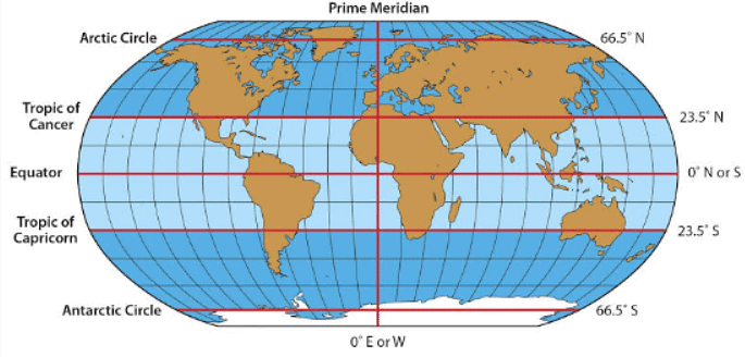
- The Equator is considered at Zero degrees, while the North Pole is at Ninety degrees North and the South Pole at Ninety degrees South.
- Latitudes are drawn at one-degree intervals from the Equator.
- There are a total of 179 latitudinal lines, with 89 in the Northern Hemisphere, 89 in the Southern Hemisphere, and one at the Equator.
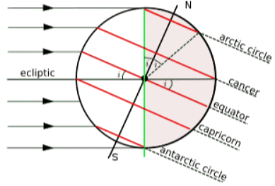
- Significant latitudes include the Equator, Tropic of Cancer, Tropic of Capricorn, Antarctic Circle, and Arctic Circle.
- The average linear distance between one degree of latitude is approximately 69 miles or 111 kilometers. However, this distance is slightly greater at the poles (about 69.407 miles) and slightly smaller at the Equator (about 68.704 miles).
- Pole Star can also be utilized to determine the latitude of a location.

Question for Latitudes & LongitudesTry yourself: What is the reference point for measuring latitude?View Solution
Notable Latitudinal Lines
- The Equator - 0 degrees
- The Tropic of Cancer - located at 23 ¼ degrees in the Northern Hemisphere
- The Tropic of Capricorn - situated at 23 ¼ degrees in the Southern Hemisphere
- The Antarctic Circle - positioned at 66 degrees in the Southern Hemisphere
- The Arctic Circle - found at 66 degrees in the Northern Hemisphere
- The North Pole - located at 90 degrees North
- The South Pole - situated at 90 degrees South

Longitudes
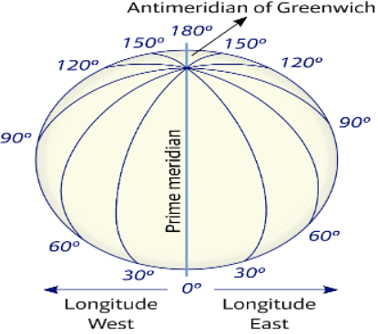
- Longitude represents the angular measurement of a location in degrees along the Equator, either east or west of the Prime Meridian. Longitudes indicate the position of a place east or west of the Prime Meridian. Unlike latitudes, which vary in length, longitudes have equal lengths.
- Unlike latitudes, longitudes do not run parallel to each other; instead, they converge at the two poles. The Prime Meridian serves as the reference point to number longitudes and is designated as 0 degrees.
- The Earth's eastern part, situated east of the Prime Meridian, is referred to as the Eastern Hemisphere, while the western part, located west of the Prime Meridian, is known as the Western Hemisphere. Longitudes are numbered from 0 degrees to 180 degrees, both east and west of the Prime Meridian.
- Lines of longitude intersect with the Equator at right angles. They are called Meridians of Longitude, and any location sharing the same longitude experiences midday or noon at the same time.
- Longitudes effectively divide the Earth into two halves, namely, the Eastern Hemisphere and the Western Hemisphere.
- The linear distance between two longitudes is maximum at the Equator, measuring about 69.172 miles, as the difference between longitudes is greatest at this point. Conversely, the distance is minimal at the poles, where longitudes converge.

Longitude and Time
- The best way to calculate time is by observing the movement of the sun, moon and other celestial objects.
- The rotation of the Earth is a method of measuring time at a place.
- The Earth completes one rotation on its axis in 24 hours. Hence, it passes through 15𝆩 in an hour.
- As we move every 15𝆩 eastwards, local time is advanced by an hour. Alternatively, if we move westwards, time is reduced by an hour.
- By this, we can conclude that places east of Greenwich experience sunrays earlier and hence gain time. Similarly, areas west of Greenwich see the sun’s rays later and hence lose time.
The document Latitudes & Longitudes | Science for ACT is a part of the ACT Course Science for ACT.
All you need of ACT at this link: ACT
|
504 videos|583 docs|357 tests
|
Related Searches


