Class 9 Geography Chapter 1 Map Based Question Answers - Contemporary India - I

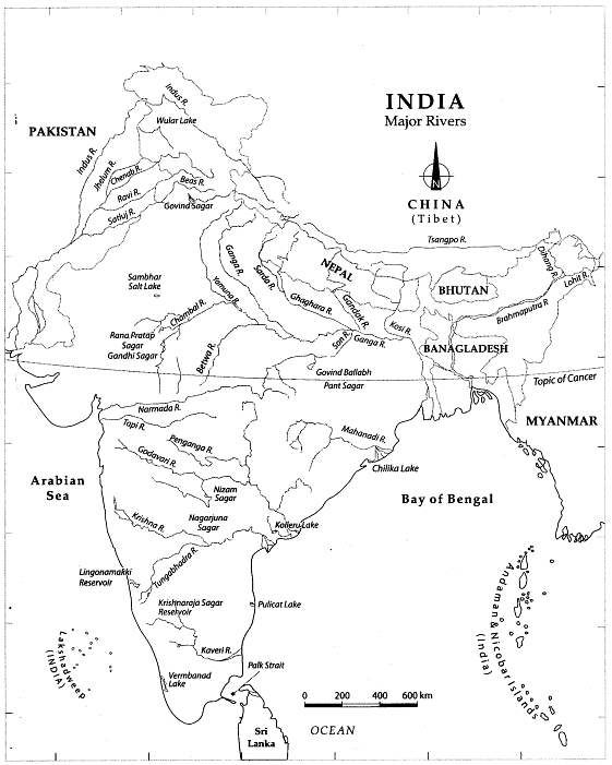
INDIA: Drainage and Lakes
This map shows various rivers that flow across the states, national capital, union territories and international boundaries. It also shows the major lakes of India.
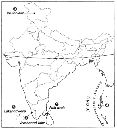
Q1: Locate and label the following items on the given map
1. The strait separating Sri Lanka and India
2. Salt water lake in Kerala
3. Largest fresh water lake in India
4. A group of islands lying East of the mainland of India
5. Islands group lying close to Malabar coast and Kerala
or
Islands in the South-West of the mainland of India
Ans:
1. Palk strait
2. Vembanad lake
3. Wular lake
4. Andaman and Nicobar islands
5. Lakshadweep
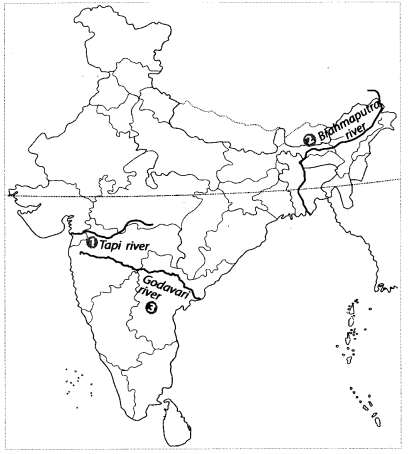
Q2: Features are marked by numbers in the given political map of India. Identify these features with the help of the following information and write their correct names on the lines marked in the map.
1. A river that rises in Betul district of Madhya Pradesh
or
A West flowing river
2. The river also known as Tsangpo
or
The largest river of North-East India
3. The largest river of South India
or
A peninsular river
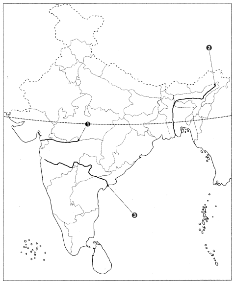
Ans:
1. Tapi river
2. Brahmaputra river
3. Godavari river
Q3: Locate and label the following items on the given map
1. A line where the time period of onset of monsoon is 1 June
2. A line where the time period of onset of monsoon is 5 June
3. A line where the time period of onset of monsoon is 1 July
Ans: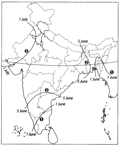
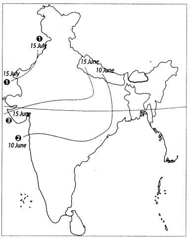
Q4: Features are marked by numbers in the given political map of India. Identify these features with the help of the following information and write their correct names on the lines marked in the map.
1. Name the date of onset of monsoon.
2. Name the date of onset of monsoon.
3. Name the date of onset of monsoon.
Ans:
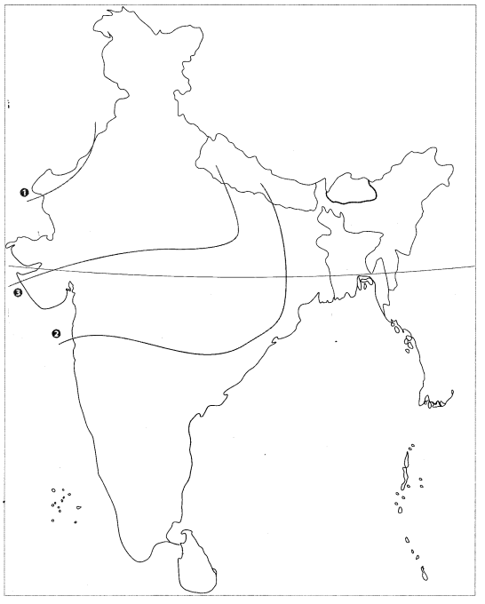
Q5: Locate and label the following items on the given map with appropriate symbols.
1. Indus river
2. Yamuna river
3. Luni river
4. Son river
Ans: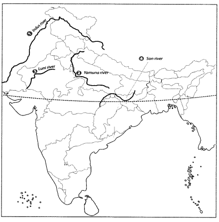
Q6: Locate and label the following items on the given map with appropriate symbols.
1. A line where the time period of onset of monsoon is 15 June.
2. A line where the time period of withdrawal of monsoon is 1 November.
3. A line where the time period of withdrawal of monsoon is 1 September.
4. Chandaka wildlife sanctuary.
5. Meteorological station Karnataka.

Ans: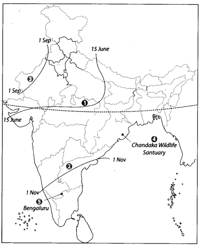
|
55 videos|525 docs|78 tests
|


study material
,Semester Notes
,ppt
,shortcuts and tricks
,Previous Year Questions with Solutions
,Important questions
,Free
,past year papers
,MCQs
,video lectures
,Summary
,Exam
,Class 9 Geography Chapter 1 Map Based Question Answers - Contemporary India - I
,Viva Questions
,practice quizzes
,Class 9 Geography Chapter 1 Map Based Question Answers - Contemporary India - I
,Class 9 Geography Chapter 1 Map Based Question Answers - Contemporary India - I
,Objective type Questions
,Sample Paper
,mock tests for examination
,Extra Questions
;


Map Based Questions: Drainage Free PDF Download
Importance of Map Based Questions: Drainage
Map Based Questions: Drainage Notes
Map Based Questions: Drainage Class 9
Study Map Based Questions: Drainage on the App
|
© EduRev
|
Education Revolution
|


|


