HOTS Questions: Globes and Maps

Q1: How do latitudes and longitudes help in locating a place on the globe?
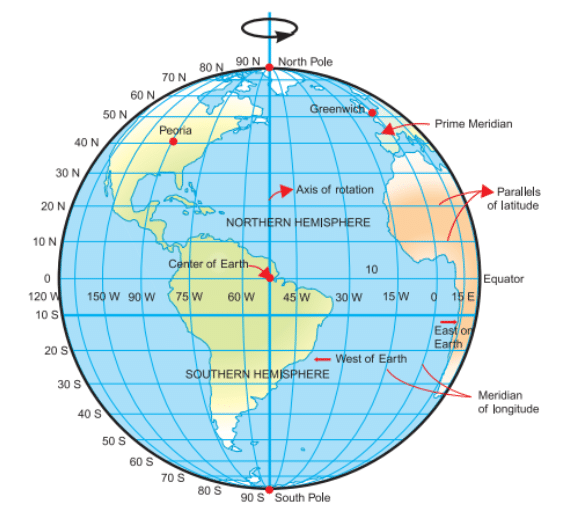
Ans: Latitudes and longitudes are imaginary lines that together form a grid on the globe. Parallels of latitude run east-west and tell how far north or south a place is from the Equator. Meridians of longitude run from the North Pole to the South Pole and tell how far east or west a place is from the Prime Meridian. The exact position of any place is given by the intersection of its latitude and longitude. For example, New Delhi is about 28.6°N latitude and 77.2°E longitude.
 Grid
GridQ2: What is the function of an axis on a globe, and what are its endpoints called?
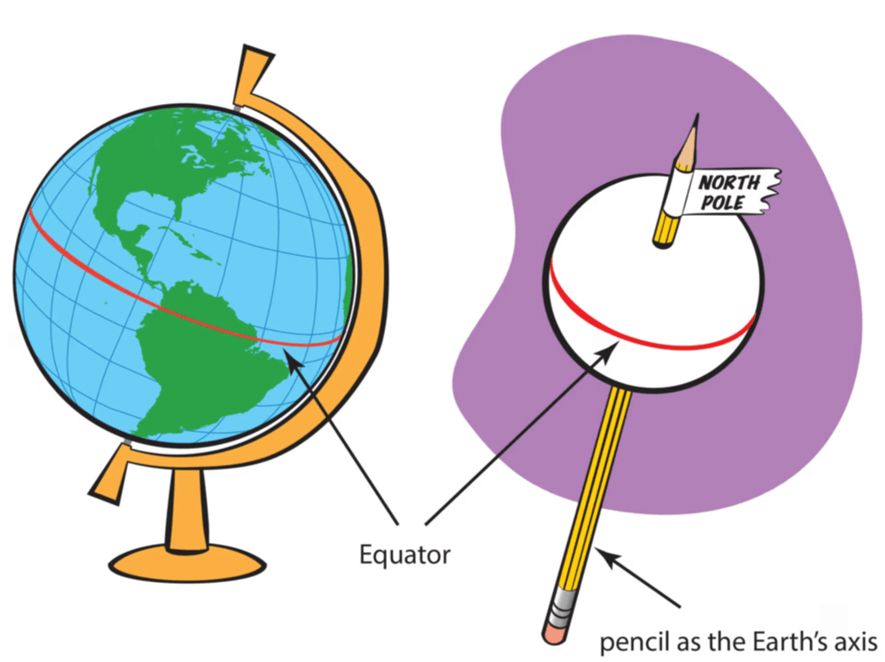
Ans: An axis is an imaginary line through the centre of the globe about which the globe rotates. The endpoints of the axis are called the North Pole and the South Pole. The axis helps show how the globe turns and is useful for explaining why different parts face the Sun at different times, causing day and night.
 Axis of Globe
Q3: Describe how latitudes are arranged on Earth and what is special about the Equator?
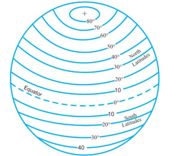
Ans: Latitudes are imaginary lines drawn parallel to the Equator around the globe. They are measured in degrees north or south of the Equator. The Equator is special because it is 0° latitude, the largest circle of latitude, and it divides the Earth into the Northern Hemisphere and the Southern Hemisphere. The poles lie at 90°N and 90°S.
 Latitudes
Q4: Explain the concept of longitudes and how they differ at the Equator compared to the poles.
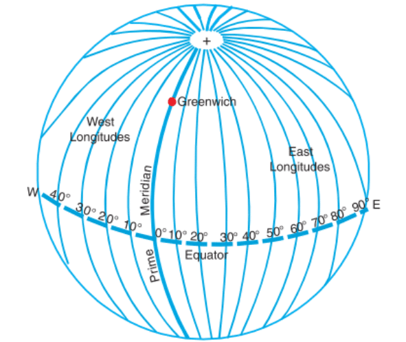
Ans: Longitudes, or meridians, are imaginary half-circles running from the North Pole to the South Pole. They are farthest apart at the Equator and come together, or converge, at the poles. Unlike latitude lines, which are parallel, longitudes meet at each pole. Longitudes are measured in degrees east or west from the Prime Meridian.
 Longitudes
Q5: How does the International Date Line affect the date when it is crossed?
Ans: The International Date Line is located close to 180° longitude. When you cross it, the calendar date changes by one day: crossing from east to west, you gain a day, and crossing from west to east, you lose a day. For example, if it is Monday just on one side of the line, crossing the line in one direction can make it Tuesday on the other side or Sunday if you cross the other way.
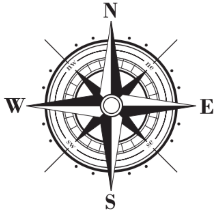
Q6: Why are sub-directions like North-East and South-West important in map reading?
Ans: Sub-directions such as North-East and South-West give more precise bearings than the four main directions. They indicate directions halfway between the main ones (for example, North-East is halfway between North and East) and help in giving clearer, more accurate directions when reading a map or describing a route.
 Directions & Sub-Directions
Q7: What purpose does the Prime Meridian serve on a globe, and why is it significant?
Ans: The Prime Meridian is the 0° longitude line that passes through Greenwich, London. It serves as the reference line from which longitudes are measured east and west. The Prime Meridian is significant because it provides the basis for world time zones and helps divide the Earth into the Eastern and Western Hemispheres, enabling precise geographical coordinates.
Q8: What is cartography?
Ans: Cartography is the art and science of making maps. Cartographers are the people who create maps using symbols, colours and scales so that others can find places, understand features and plan routes. Good maps show clear symbols, correct scale and helpful labels.
Q9: Why do the maps of the larger areas have chances of more errors?
Ans: Maps of larger areas have more chances of errors because when we try to put the curved surface of the Earth onto a flat sheet of paper, parts of the surface get stretched, squashed or distorted. Different map projections try to reduce some kinds of distortion, but none can avoid all errors. A simple way to imagine this is to think of trying to flatten an orange peel onto paper - some parts will not fit perfectly.
Q10: What are the elements of a map? What is the importance of elements in a map?
Ans:
- Directions: Show which way is north, south, east and west so we can orient the map.
- Scale: Shows how distances on the map relate to actual ground distances so we can measure how far places are.
- Symbols (Legend): Explain the signs used for rivers, roads, cities, mountains and other features.
- Colours: Help to show different land types such as forests, deserts and water bodies.
- Labels and Title: Give names to places and tell what the map is about so the reader understands it quickly.
Together, these elements make a map easy to read and help us find places, measure distances and understand the information shown.
Q11: Why do you think it is impossible to see the whole globe at once without rotating it?
Ans: A globe is a spherical model of the Earth, so from any single viewpoint, you can see only one half (a hemisphere) at a time. To see other parts, you must rotate the globe. This is why it is impossible to view the whole globe at once without turning it.
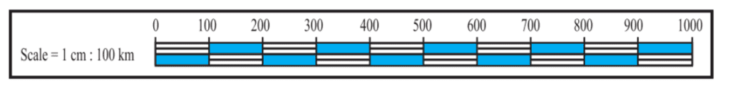
Q12: What does the scale of a map indicate?
Ans: The scale of a map shows the ratio between a distance on the map and the corresponding distance on the ground. For example, a scale might mean that 1 cm on the map equals 100 km on the ground. Scale helps users measure distances and understand how much area the map covers.
FAQs on HOTS Questions: Globes and Maps
| 1. What is the difference between a globe and a map? |  |
| 2. Why are maps important for understanding geography? | |
| 3. How do scale and symbols work on a map? | |
| 4. What are the different types of maps, and what do they show? | |
| 5. How can I use a globe or map to find my location? | |


