Important Questions: Landforms & their Evolution

Very Short Answer Type Questions
Q1: What is a landform?
Ans: A landform is a distinct natural feature of the Earth's surface, typically a small to medium-sized area such as a hill, valley, plateau or plain that can be identified by its shape and origin.
Q2: What are cirque lakes?
Ans: Cirque lakes are small, often circular lakes that occupy bowl-shaped hollows (cirques) carved into mountain sides by glacier action; they form when a glacier retreats and meltwater fills the hollow.
Q3: How do climatic changes affect landform evolution?
Ans: Climatic changes alter the rates and types of weathering, erosion and deposition. For example, increased rainfall raises river discharge and erosion, colder climates favour glacial erosion and deposition, while arid conditions enhance wind action and rapid mechanical weathering; tectonic movements combined with climate shifts also change slopes and drainage patterns, producing new or modified landforms.
Q4: Arrange the following from smaller to bigger form: stream, gully, river, rill.
Ans: Rill, gully, stream, river.
Q5: Name two basic forms in which the running water acts as a geomorphic agent.
Ans: Overland flow (sheet flow) and channel or streamflow. Overland flow is a thin sheet of water moving across the surface; channel flow is concentrated movement within defined stream channels.
Q6: What are three closely inter-related geomorphic works performed by rivers?
Ans: Erosion, transportation and deposition. These processes are linked: erosion supplies material, transportation moves it downstream, and deposition builds new landforms where the river's energy falls.
Q7: What is Karst topography?
Ans: Karst topography is a landscape formed by the chemical weathering and dissolution of soluble rocks (mainly limestone and dolomite) by groundwater. It produces features such as sinkholes (dolines), disappearing streams, caves, underground drainage and limestone pavements.
Q8: Why is wind action most prominent in arid and semi-arid areas?
Ans: Wind action is most prominent because soils are loose and dry, vegetation cover is sparse and surface moisture is low; these conditions allow wind to pick up, transport and deposit particles easily, making aeolian processes dominant in such regions.
Short Answer Type Questions
Q9: How does wind affect rocks and what kinds of rocks are eroded the fastest? Explain the formation of landforms by winds.
Ans: Wind affects rocks by three main actions: deflation (removal of loose particles), abrasion (sand-particle wear on exposed surfaces) and impact (hitting and chipping of surfaces by wind-driven grains). The fastest eroded materials are loose, unconsolidated and dry sediments such as sand and fine silt found in deserts and semi-arid regions. Erosional landforms created by wind include deflation hollows, pedestals or mushroom rocks and extensive plains such as pediments and pediplains; depositional landforms include various types of sand dunes (barchan, parabolic, seif/linear, longitudinal and transverse), formed when wind velocity drops or is deflected by obstacles, causing sand to settle and accumulate.
Q10: What is a fiord?
Ans: A fiord (or fjord) is a deep, narrow inlet of the sea with steep sides or cliffs, formed when a glacial trough is flooded by rising sea level or by subsidence. Fiords are common along coasts that experienced glaciation, for example in Norway and Chile.
Q11: Define fluvial denudation.
Ans: Fluvial denudation is the lowering and wearing down of the land surface by the action of running water (streams and rivers) through combined processes of weathering, erosion, transportation and deposition, which gradually reduce relief and redistribute sediments.
Q12: Discuss the features developed due to falling rain on bare surfaces.
Ans:
- Raindrop impact loosens and dislodges soil particles, producing surface detachment and muddy runoff.
- A thin sheet of flowing water (sheet flow or overland flow) transports these particles downslope before channels form.
- On steeper slopes or where flow concentrates, sheet flow becomes small channels called rills.
- Continued erosion and headward enlargement of rills form deeper and wider gullies.
- When gullies are extensive and the material is easily erodible, the landscape may develop into badland topography with heavily dissected, barren terrain.
Q13: How are lagoons formed? Give two examples of lagoons from India.
Ans: Lagoons form when sandbars, spits or barrier islands build across the mouth of a bay or along a coast and enclose a shallow body of water separated from the open sea. Two Indian examples are:
- Chilka Lake (Odisha)
- Pulicat Lake (Tamil Nadu / Andhra Pradesh border)
Long Answer Type Questions
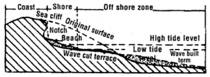
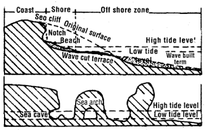
Q14: Discuss features created by wave action.
Ans: Wave action at the coast produces both erosional and depositional features by attacking, transporting and laying down material along the shore.
Erosional features:
- Abrasion platform (wave-cut platform) - a gently sloping bench formed by wave erosion at the base of cliffs and exposed at low tide.
- Marine cliff - a steep slope or cliff rising directly from the abrasion platform, created by continuous wave undercutting.
- Wave-cut notch and sea-cave - hollows formed at the cliff base where wave energy concentrates and removes rock.
- Arches and stacks - arches form when caves on opposite sides of a headland meet; stacks are the isolated rock columns left after an arch collapses.
Depositional features:
- Beaches - accumulations of sand, shingle or pebbles along the shore deposited by wave action and longshore movement.
- Bars and barrier islands - ridges of sand or gravel deposited parallel to the coast that may enclose lagoons and protect the mainland.
- Spits and tombolos - elongated deposits formed by longshore drift; a tombolo links an island to the mainland when material is deposited in its lee.
Q15: Write an essay on the geomorphic work of rivers,
Ans:
Erosion by rivers
- Rivers shape the landscape through three linked processes: erosion, transportation and deposition.
- In the upper or youthful course a river has a steep gradient and high energy, so vertical erosion dominates and the river cuts down to form narrow V-shaped valleys, interlocking spurs, rapids and waterfalls.
- In the middle or mature course the gradient falls, lateral erosion becomes more important and the valley widens, producing meanders and floodplains.
- In the lower or old course velocity further decreases and deposition dominates, building up plains and other depositional features.
Transportation
- Rivers carry material as bed load (larger particles that roll, slide or bounce along the channel), suspended load (silt and clay kept in suspension) and dissolved load (ions in solution).
- Coarser material is deposited nearer the source while finer particles are transported further downstream.
Deposition and resultant landforms
When river velocity decreases, sediments are deposited to form a variety of landforms:
- Alluvial fans and cones - formed where a stream leaves steep, confined terrain and spreads out onto a plain, dropping coarser load at the mountain front.
- Floodplains and natural levees - built by repeated overbank deposition during floods; levees form from coarser material at the channel edges.
- Meanders and oxbow lakes - meanders migrate laterally by erosion and deposition; when a meander is cut off it forms an oxbow lake.
- Deltas - depositional lobes created where a river enters standing water and deposits its load, for example the Sundarbans delta of the Ganga-Brahmaputra system.
Importance
The geomorphic work of rivers builds fertile plains, redistributes sediments, creates diverse habitats and strongly influences human settlement, agriculture and transport. Human activities such as dam construction and channel modification can significantly alter these natural river processes.
Q16: Which is the most important agent modifying the coastal topography? Describe the various features formed by this agent of gradation.
Ans: The most important agent modifying coastal topography is sea waves (wave action). Waves erode rocky coasts, transport sediments along the shore and deposit material to form a range of coastal landforms.
- Erosional features: wave-cut platform, marine cliffs, notches, sea-caves, arches and stacks.
- Depositional features: beaches, bars, spits, tombolos, barrier islands and lagoons.
Q17: Distinguish between:
(i) V-shaped valley and U-shaped valley.
Ans:
- V-shaped valley: Formed mainly by river erosion; the cross-section resembles a V with steep sides and a narrow bottom. It is typical of youthful river stages and reflects dominant vertical erosion.
- U-shaped valley: Formed by glacier erosion; the cross-section resembles a U with a broad, flat floor and steep sides. It is characteristic of valleys shaped by moving ice.
(ii) Valley glacier and Continental glacier.
Ans:
- Valley glacier: A stream of ice confined within a mountain valley; long and narrow and flowing downhill under gravity.
- Continental glacier (ice sheet): A vast, thick ice mass that covers large continental areas (for example Antarctica and Greenland), not confined by local topography and spreading outward.
(iii) Gorge and Canyon.
Ans:
- Gorge: A narrow, steep-sided valley often formed by river erosion in resistant rocks; it is usually deep compared with its width.
- Canyon: A large, deep valley with very steep sides, typically formed by long-term river erosion over wide areas; can be broader and deeper than a gorge (for example, the Grand Canyon).
Q18: Discuss the internal and external forces involved in the creation of landforms.
Ans:
Internal forces (endogenic)
- Tectonic activity: Movements of Earth's plates produce folding, faulting and uplift that form mountains, rift valleys and basins.
- Volcanism: Eruption of magma builds volcanic cones, lava plateaus and volcanic islands.
- Isostatic and diastrophic movements: Long-term adjustments of the crust cause regional uplift or subsidence, changing land elevation.
External forces (exogenic)
- Weathering: Physical, chemical and biological breakdown of rocks to produce regolith and soil, preparing material for transport.
- Erosion and transport: Agents such as running water, glaciers, wind and waves remove and carry material from one place to another.
- Deposition: Settling of transported sediments builds landforms like alluvial plains, deltas, beaches and dunes.
- Biological activity: Plants and organisms influence weathering rates, stabilise surfaces and modify sediment behaviour.
The continual interaction of internal uplift and external denudation over geological time produces the wide variety of Earth's surface forms.
Q 19 : Explain the different stages of a river.
Ans :
- Youth stage: Steep gradients and high energy cause dominant vertical erosion, producing narrow V-shaped valleys, interlocking spurs, waterfalls and rapids. Floodplains are absent or very limited.
- Mature stage: Gradient decreases and lateral erosion increases, widening the valley. Meanders develop and floodplains become broader as the stream profile smooths out.
- Old stage: Very gentle gradients prevail; extensive meandering occurs over wide floodplains. Deposition dominates, forming natural levees, oxbow lakes and broad alluvial plains as the river approaches its base level.
Q20: Write a short note on the formation of sand dunes.
Ans: Sand dunes form when wind transports sand grains and deposit them where wind speed falls or is obstructed.
Key points:
- Barchan dunes - crescent-shaped with horns pointing downwind; form where sand supply is limited and wind direction is fairly constant.
- Parabolic dunes - U-shaped with horns pointing upwind; form where vegetation partially anchors sand, commonly in coastal areas.
- Seif (linear) dunes - long, narrow ridges aligned with prevailing wind direction; form under bidirectional or consistent winds.
- Longitudinal dunes - long parallel ridges formed by winds from similar directions and moderate sand supply.
Obstacles such as rocks or vegetation and changes in wind strength initiate dune formation; sorting of grains by wind and repeated deposition shape the distinctive dune forms.
FAQs on Important Questions: Landforms & their Evolution
| 1. What's the difference between weathering and erosion in landform formation? |  |
| 2. How do river landforms like meanders and deltas actually form over time? | |
| 3. Why do mountains and plateaus have different shapes even though both are elevated landforms? | |
| 4. What role does tectonic activity play in creating different types of landforms? | |
| 5. How does glaciation reshape landscapes into distinct landforms like U-shaped valleys and cirques? | |


