Class 5 Maths Chapter 8 Important Question Answers - Chapter 8 - Mapping your Way

Q1: Use a ruler to measure the distance in cm between the places joined by dotted lines. If the map has been drawn using the scale 1 cm : 10km, find the actual distances between
(1) School and Library
(2) College and Complex
(3) House and School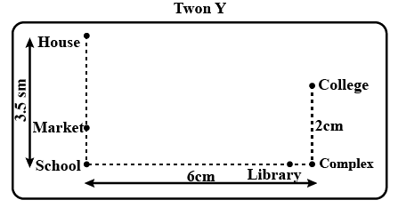
Ans: As per question,
(1) In the given figure, the distance between school and library = 6 cm
So, the actual distance = 6 × 10 = 60 km
(2) In the given figure, the distance between college and complex = 2 cm
So, the actual distance = 2 × 10 = 20 km
(3) In the given figure, the distance between school and house = 3.5 cm
Q2: Study the given map of a zoo and answer the following questions. Give the location of lions in the zoo.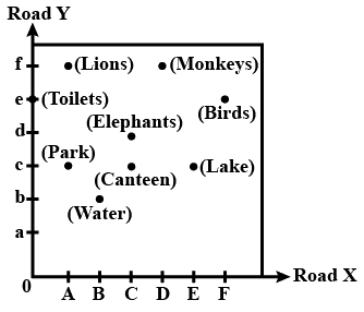
Ans: From the given map, The location of lions in the zoo = (A, f)
Q3: Ashish is travelling from Hyderabad to Vijayawada. He saw this board on the highway road while starting. Which distance is more - Suryapet to Kodad or Kodad to Vijayawada?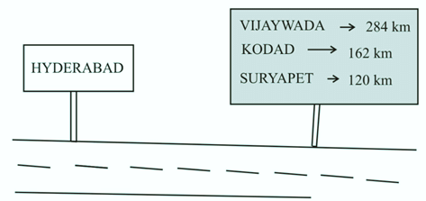
Ans: To find which distance is more
Since, SURYAPET → 120 Km
VIJAYAWADA→ 284 Km
KODAD→162 Km
Therefore, distance from Suryapet to Kodad can be calculated as
= 162 − 120
= 40 Km
Now, distance from Kodad to Vijayawada can be calculated as
= 284 − 162
= 122 Km Hence, it is clear that distance from Kodad to Vijayawada ismore than Suryapet to Kodad.
Q4: How many points are marked in the following figures? Name them.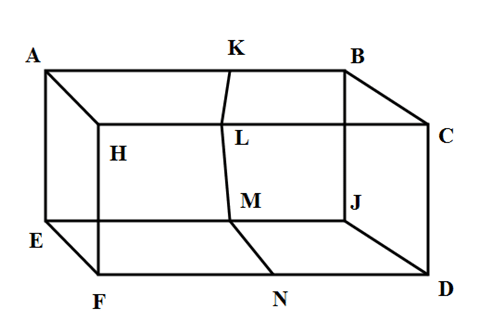
Ans: 12 points are marked in the figure namely A, H, K, L, B, C, J, D, M, N, E, F
Q5: The distance between school and house of a girl is given by 5 cm in a picture, using the scale 1cm: 5 km. Find the actual distance between the two places?
Ans: Given The scale 1 cm : 5 km
So, 5cm in picture = 5 × 5 km of actual distance
= 25 k m of actual distance
Therefore, the actual distance among two places = 25 km
Now, we can say that 5 c m shows = 25 km of actual distance.
Q6: In the map of India, the distance between two cities is 13.8 cm. Taking scale : 1 cm = 12 km , find the actual distance between these two cities.
Ans: It is given that
Scale for a map is 1 cm = 12 km
We know that
Distance between two cities on the map = 13.8 cm
So the actual distance between these two cities = 12 × 13.8 = 165.6 km
Q7: Height of a building is 9 m and this building is represented by 9 cm on a map. What is the scale used for the map?
Ans: Given: The height of the building is 9m.
9m is represented by 9 cm on the map.
We know that 1 m = 100 cm
therefore, 9m : 9c m ⇒ 900 cm : 9 cm
Scale used ⇒ 100 : 1
Q8: Look at the map given below. Houses Now answer the following questions.
(a) Name the roads that meet at round about.
(b) What is the address of the stadium?
(c) On which road is the Police Station situated?
(d) If Ritika stays adjacent to bank and you have to send her a card, what address will you write?
(e) Which sector has maximum number of houses?
(f) In which sector is Fire Station located?
(g) In the map, how many sectors have been shown?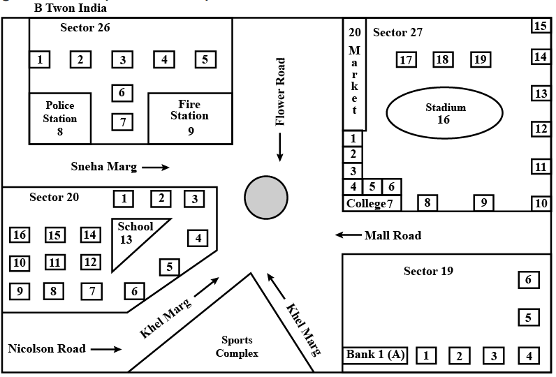
Ans: As per question
(a) Name of road are : Khel road , Flower road and Sneha road.
(b) Address of the stadium : sector 27, B- Town, India.
(c) Location of police station : Sneha road
(d) Sneha 's address : H.N. - 1Nr.,Bank 1 (A), Sector 19,B town India
(e) Maximum number of house : Sector 27
(f) Location of fire station : Sector 26
(g) Total sector in the given map : four
Q9: Refer to the given map to answer the following questions.
(a) What is the built-up area of Govt. Model School I?
(b) Name the school shown in the picture.
(c) Which park is nearest to the dispensary?
(d) To which block does the main market belong?
(e) How many parks have been represented in the map?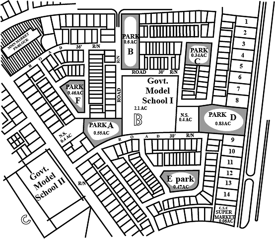
Ans: (a) 2.1 acre
(b) Govt. model school i and govt. model school are two school shown in picture
(c) Park A
(d) Block A
(e) Six parks
Q10: A map to scale is drawn for a state. If it takes 4 hours to travel a distance shown as 8 cm on the map, find the time required to travel from city A to city B which are shown away by 5 cm distance from each other on the map.
Ans: Time taken to travel 8 cm = 4 hours.
∴ Time taken to travel 1 cm = 4/8 hours.
∴ Time taken to travel 5 cm = 4/8 × 5 = 5/2 hours.
= 21/2 hours.
= 2 hours 30 minutes.
|
31 videos|192 docs|41 tests
|


Class 5 Maths Chapter 8 Important Question Answers - Chapter 8 - Mapping your Way
,Class 5 Maths Chapter 8 Important Question Answers - Chapter 8 - Mapping your Way
,mock tests for examination
,Free
,Exam
,Viva Questions
,Important questions
,Summary
,shortcuts and tricks
,Sample Paper
,Class 5 Maths Chapter 8 Important Question Answers - Chapter 8 - Mapping your Way
,Semester Notes
,Extra Questions
,video lectures
,Objective type Questions
,practice quizzes
,Previous Year Questions with Solutions
,past year papers
,MCQs
,ppt
,study material
;


Important Questions: Mapping Your Way Free PDF Download
Importance of Important Questions: Mapping Your Way
Important Questions: Mapping Your Way Notes
Important Questions: Mapping Your Way Class 5
Study Important Questions: Mapping Your Way on the App
|
© EduRev
|
Education Revolution
|


|


