Class 5 Exam  >  Class 5 Notes  >  Be an Explorer 5: Book Solutions, Notes & Worksheets  >  Worksheet: Map and Globe

Worksheet: Map and Globe | Be an Explorer 5: Book Solutions, Notes & Worksheets - Class 5 PDF Download

Q1: Multiple Choice Questions (MCQs).

(i) What did Ferdinand Magellan's expedition prove about the shape of the Earth?
(a) 
Flat
(b) Spherical
(c) Square
(d) Triangular

(ii) What does the word 'globe' mean in Latin?
(a) 
Square
(b) Round mass
(c) Flat
(d) Triangle

(iii) Why do we use a globe to study the Earth?
(a)
It is easy to carry around
(b) It shows detailed geographical information
(c) It provides the correct shape of the Earth
(d) All of the above

(iv) What is the limitation of using a globe?
(a)
It cannot show physical features
(b) It cannot be rotated
(c) It cannot show a part of the Earth
(d) It is too small

(v) Why can't a map show the correct shape of the Earth?
(a) 
Maps are flat
(b) Earth is too big
(c) Earth is spherical
(d) Maps cannot show details

Q2: Fill in the Blanks.

(i) __________ maps show physical features like mountains and rivers.

(ii) A person who makes maps is known as a __________.

(iii) Thematic maps focus on specific __________ information.

(iv) The four cardinal directions are __________, __________, __________, and __________.

(v) A scale on a map is a ratio between the distance on a map and the actual distance on the __________.

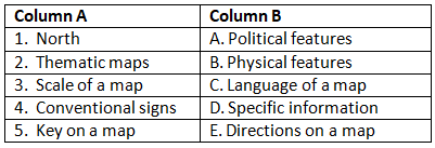
Q3: Match the Column.

Worksheet: Map and Globe | Be an Explorer 5: Book Solutions, Notes & Worksheets - Class 5

Download the notes
Worksheet: Map and Globe
Download as PDF
Download as PDF

Q4: True or False.

(i) Asia is the smallest continent.

(ii) The Atlantic Ocean is the largest and deepest ocean.

(iii) Antarctica remains covered with ice throughout the year.

(iv) South America is also known as Latin America.

(v) The Indian Ocean is not named after any country.

You can access the solutions to this worksheet here.

The document Worksheet: Map and Globe | Be an Explorer 5: Book Solutions, Notes & Worksheets - Class 5 is a part of the Class 5 Course Be an Explorer 5: Book Solutions, Notes & Worksheets.
All you need of Class 5 at this link: Class 5
Are you preparing for Class 5 Exam? Then you should check out the best video lectures, notes, free mock test series, crash course and much more provided by EduRev. You also get your detailed analysis and report cards along with 24x7 doubt solving for you to excel in Class 5 exam. So join EduRev now and revolutionise the way you learn!
Sign up for Free Download App for Free
95 docs

Up next

FAQs on Worksheet: Map and Globe - Be an Explorer 5: Book Solutions, Notes & Worksheets - Class 5

1. What are the main differences between a map and a globe?
Ans.A map is a flat representation of an area, showing various features like roads, cities, and geographical boundaries, while a globe is a three-dimensional model of the Earth, providing a realistic view of its shape and size. Maps can be detailed and specific to certain themes, while globes give a broader perspective of the world.
2. How do you read a map effectively?
Ans.To read a map effectively, start by understanding the map key or legend, which explains symbols and colors used. Then, locate your position using landmarks or coordinates, and follow the scale to understand distances. Familiarize yourself with cardinal directions (North, South, East, West) to navigate accurately.
3. Why are maps important for learning geography?
Ans.Maps are essential for learning geography because they provide visual representations of locations, physical features, and human-made structures. They help students understand spatial relationships, navigate the world, and develop critical thinking skills by analyzing various geographic data.
4. What types of maps are commonly used in education?
Ans.Common types of maps used in education include political maps, which show boundaries and capitals; physical maps, which display natural features like mountains and rivers; thematic maps, focusing on specific topics like climate or population; and topographic maps, which illustrate elevation changes and terrain.
5. How can students create their own maps?
Ans.Students can create their own maps by first choosing an area to represent, then gathering information on the features they want to include. They should sketch the layout, use symbols for key locations, and label their map clearly. Using colors can help differentiate between various elements, making the map visually appealing and informative.

Up next

Explore Courses for Class 5 exam
Related Searches

Exam

,

Notes & Worksheets - Class 5

,

Viva Questions

,

Notes & Worksheets - Class 5

,

mock tests for examination

,

study material

,

Important questions

,

Summary

,

Extra Questions

,

Worksheet: Map and Globe | Be an Explorer 5: Book Solutions

,

ppt

,

past year papers

,

shortcuts and tricks

,

Objective type Questions

,

Previous Year Questions with Solutions

,

Sample Paper

,

Notes & Worksheets - Class 5

,

Free

,

MCQs

,

pdf

,

video lectures

,

practice quizzes

,

Worksheet: Map and Globe | Be an Explorer 5: Book Solutions

,

Worksheet: Map and Globe | Be an Explorer 5: Book Solutions

,

Semester Notes

;