Disaster Management | HPSC Preparation: All subjects - HPSC (Haryana) PDF Download
| Table of contents |

|
| Introduction |

|
| Types of Disasters |

|
| Hazards |

|
| Disaster Management |

|
| Sub-Region and Hazards |

|
| Earthquake History |

|
| Flood Hazard & Disaster |

|
| Flood Situation |

|
Introduction
The effective management of disasters is a matter of national importance. The legislation outlines a structured framework of functions and duties across various administrative levels, ranging from the national level down to the Panchayat level. Each district is mandated to formulate a Disaster Management Plan, a task assigned to the District Authority in collaboration with local authorities and in alignment with the National Plan and State Plan.
Types of Disasters
According to the National Disaster Management Act of 2005, a disaster is defined as "a catastrophe, mishap, calamity, or significant event impacting any area, resulting from either natural or human-made causes, or occurring due to accident or negligence. Such events lead to considerable loss of life or human suffering, substantial damage to property, destruction of property, or harm to, and deterioration of, the environment. Additionally, these events are characterized by a nature or magnitude that exceeds the coping capacity of the affected community."
The United Nations (UNDRO 1987, cited in Hanisch 1996, p.22) define disasters in the following way:
"A disaster is an occurrence concentrated in space and time, posing severe danger to a society and resulting in significant loss of human life or major material damage, leading to the breakdown of the local social structure. The society becomes incapable of performing some or all of its key functions.
In its October 2001 report, the high-powered committee of the Government of India defines disaster as an incident of severity and magnitude typically causing deaths, injuries, and property damage beyond the capacity of routine government procedures and resources. It usually arises suddenly and unexpectedly, necessitating an immediate, coordinated, and effective response from various government and private sector organizations to address human needs and ensure rapid recovery.
According to the World Health Organization (WHO), a disaster is any incident causing damage, economic destruction, loss of human life, and deterioration in health and health services on a scale sufficient to warrant an extraordinary response from entities outside the affected community or area. A disaster results from a hazard, such as an earthquake, flood, or windstorm, coinciding with a vulnerable situation, potentially involving communities, cities, or villages." There are two kinds of disasters:
- Natural disaster- disasters with meteorological, geological or even biological origin such as earth
- quake, floods, high winds, fire hazard, etc.
- Unnatural or man-made disaster- disasters caused by humans or technological origin such as nuclear, chemical, etc.
Hazards
Hazards are defined as occurrences that pose a threat to people, structures, or economic assets and have the potential to lead to a disaster. These hazards may be either human-made or naturally occurring in our environment, as stated by UNDRO. A natural hazard refers to a phenomenon in proximity that poses a threat to people, structures, and economic assets due to biological, geological, seismic, hydrological, or meteorological conditions or processes in the natural environment.
A disaster emerges when a hazard, such as an earthquake, flood, or windstorm, coincides with a vulnerable situation that could involve communities, cities, or villages. This definition hinges on two essential components: the hazard itself and the vulnerability of the affected area. Without both factors, an event cannot be classified as a disaster.
Classification of Hazards
There are four fundamental types of hazardous events that pose risks to societies:
- Nature-based: Earthquakes, floods, droughts, cyclones, tsunamis, heat/cold waves, landslides, hailstorms, and avalanches.
- Violence-driven: War, armed conflict, physical assaults, etc.
- Deterioration-led: Declining health, education, and other social services, environmental degradation, etc.
- Industrialization failure-led: Technological failures, oil spillage, factory explosions, fires, gas leakage, transport collisions.
Vulnerability
Vulnerability is characterized as "The degree to which a community, structure, service, or geographical area is susceptible to damage or disruption from the impact of a specific hazard, based on their nature, construction, and proximity to hazardous terrain or disaster-prone regions."
Vulnerability and Risk Assessment of the region due to natural Hazards
The vulnerability assessment as per Atlas of India indicates that the National Capital Region falls within:
- High damage risk zone (MSK VIII) with regard to earthquake
- Very high damage risk zone B (Vb = 50 m/s) with regard to wind and cyclone hazard and
- Area liable to floods
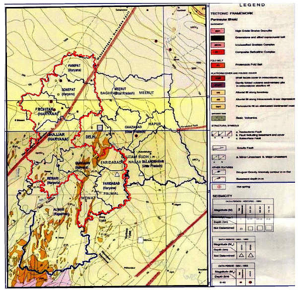
The occurrence of earthquakes in and around sub-region is attributed to the following prominent tectonic features:
- Sohna fault
- Aravali fault
- The hidden Moradabad fault
- Sonipat-Delhi-Sohna fault
- Junction of Aravali and Sohna fault
- Delhi Haridwar ridge
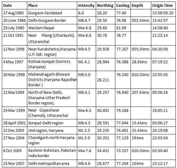
Earthquakes of intensity lower than four on the Richter scale have originated at about 10 epicenters that lie in the Sub-region as also shown in Map 15-1. The Mahendragarh-Dehradun Fault line passes through Jhajjar and Rohtak districts
Risk
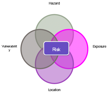
Risk is a quantification of anticipated losses, encompassing deaths, injuries, property damage, economic activity, etc., resulting from a hazard of a specific magnitude occurring within a designated area over a defined time period. Figure 15-1 delineates four contributing factors to risk: hazards, location, exposure, and vulnerability.
They are:
- Hazards (physical effects generated in the naturally occurring event),
- Location of the hazards relative to the community at risk,
- Exposure (the value and importance of the various types of structures and lifeline systems such as water supply, communication network, transportation network etc.)
- Vulnerability of the exposed structures, to the hazards expected to affect them
Disaster Management
Disaster Management, as per the Indian National Disaster Management Act of 2005, refers to an ongoing and cohesive process involving the planning, organization, coordination, and implementation of measures deemed necessary or expedient for:
(1) Preventing the occurrence of any disaster or its threat,
(2) Mitigating or reducing the risk, severity, or consequences of any disaster,
(3) Capacity building,
(4) Preparedness for handling disasters,
(5) Swift response to impending disaster situations,
(6) Assessing the magnitude and severity of disaster effects,
(7) Executing evacuation, rescue, and relief efforts, and
(8) Engaging in rehabilitation and reconstruction initiatives.
The High Powered Committee defined Disaster Management as “a collective term encompassing all aspects of planning for and responding to disasters, including both pre and post disaster activities. It may refer to the management of both the risks and consequences of disasters”. Preparedness of disaster management could be divided into two phases:
A- Pre disaster phase
B- Post disaster phase
Pre disaster phase
- Risk identification
(i) Hazard Assessment
(ii) Vulnerability Assessment - Mitigation
(i) Physical/structural mitigation works
(ii) Land-use planning and building codes
(iii) Education, training and awareness about risks and prevention - Risk transfer
(i) Insurance (Individual, Family, Community)
(ii) Insurance of public infrastructure and private assets
(iii) Privatization of public services with safety regulation (energy, water and transportation)
(iv) Calamity Funds - Preparedness
(i) Development of Disaster Management Plan
(ii) Setting of Control Room
(iii) Setting of Wireless Station
(iv) Constitution of Flood Zones
(v) Deployment of Country Boats
(vi) Storage and Stock Piling of Emergency Relief
(vii) Identification of Weak and Vulnerable Points
(viii) Awareness Generation
(ix) Mock Drill
(x) Selection of Flood / Cyclone Shelters/ Mounds
(xi) Alternative Communication and Road Net Works
(xii) Arrangement of vehicle for relief and rescue operation
Post disaster phase
Emergency response
(i) Humanitarian assistance
(ii) Sanitation, temporary repairs, and restoration of services
(iii) Damage assessment
(iv) Mobilization of resourcesRehabilitation & Reconstruction
(i) Rehabilitation and reconstruction of damaged critical infrastructure
(ii) Revitalization of for affected sectors
(iii) Macro- economic and budget management (stabilization and protection of social expenditures)
(iv) Incorporation of disaster mitigation components in reconstruction activities
Sub-Region and Hazards
The geological and geomorphological configuration of Haryana renders it susceptible to various natural hazards, including floods, waterlogging, soil salinity, soil erosion, landslides, and drought. These natural hazards have a significant impact on infrastructure, resulting in the loss of natural resources and human lives. Earthquakes, floods, cyclones, and landslides are particularly feared as potential disasters in India, with this apprehension naturally heightened in the districts of Faridabad and Gurgaon.
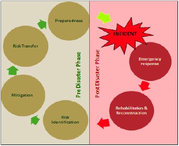 Pre & Post Disaster Management Phases
Types of hazards in Sub-Region
Earthquake Hazard & Disaster :An Earthquake is a series of underground shock waves and movements on the earth’s surface caused by natural processes of writhing of the earth’s crust.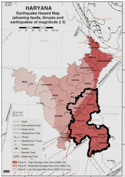
Earthquake History
The eastern regions of Haryana, along with Delhi, are situated in the Gangetic Plain. This geographical area represents a downward deformation of the Himalayan foreland, displaying variable depth and transformed into flat plains through prolonged and robust sedimentation. Referred to as a geosyncline, the Gangetic Plain is part of the Indo-Gangetic Geosyncline. It exhibits notable flexure and dislocation, particularly at its northern end, bounded to the north by the Himalayan Frontal Thrust.
The floor of the Gangetic trough, if observed without sediment cover, reveals uneven terrain marked by corrugated irregularities and buried ridges, known as shelf faults. Positioned over the Delhi-Haridwar ridge, a subsurface ridge trending NE-SW, this region features several faults, including the Moradabad, Panipat, and Sohna faults. Notably, Delhi, Chandigarh, and many parts of Haryana fall within Zone IV, rendering them highly susceptible to earthquakes. While most earthquakes in this region are shallow, a few of intermediate depth have been recorded in Haryana. The alluvial cover of the Indo-Gangetic plain amplifies the impact of even distant earthquakes, making them strongly felt here.
This area frequently experiences deep-seated earthquakes originating from the Pakistan-Afghanistan Border and the Hindukush mountains in Afghanistan. However, it is essential to note that proximity to faults does not necessarily correlate with a higher seismic hazard compared to more distant areas. The extent of earthquake damage depends on various factors such as subsurface geology and compliance with building codes.
Seismic Hazard
Every district within the Haryana sub-region is situated in Zone IV and falls into the High Damage Risk Zone (MSK VIII) concerning earthquakes. However, it's important to note that the earthquake database only covers seismic events occurring after the historical period, specifically post-1800 A.D. Therefore, these zones provide a provisional understanding of earthquake hazard and require regular updates for accuracy.
Earthquakes felt in the Haryana Sub-Region and surroundings
Status of sub-region
The sub-region lies in Zone IV and Shaking Intensity VIII.
i) Nature - Minor landslides occur in depressions and on embanked roads, with ground cracks extending up to several centimeters. Lakes experience increased turbidity in the water. New reservoirs are formed, and dry wells begin to refill.
Analysis from Existing situation
Gurgaon, as a whole, is positioned within the high-risk seismic Zone IV, aligning with an MSK intensity of VIII. This classification renders the area highly susceptible to earthquakes. The major tectonic features affecting Gurgaon are as follows;
- The Sohna Fault
- Junction of Aravali and Alluvia near Delhi
- Moradabad Fault
- Delhi Moradabad Fault
- Delhi-Haridwar Fault
Classification of Damage to buildings

Focus areas analysis

Flood Hazard & Disaster
A flood is a transient submersion of a vast area, resulting from heightened reservoir levels, rivers overflowing their banks due to substantial rainfall, strong winds, cyclones, storm surges along the coast, tsunamis, melting snow, or dam ruptures. In the Haryana sub-region, the likelihood of flooding is more characterized as a hazard rather than a disaster. Regions situated in low-lying contour zones with heterogeneous topography and along the Yamuna River are prone to flood hazards. There have been numerous instances when various districts experienced flood hazards primarily due to intense monsoon rainfall and increased discharge in the Yamuna River.
History of flood
Major known flood disasters which have taken place in the Sub-Region
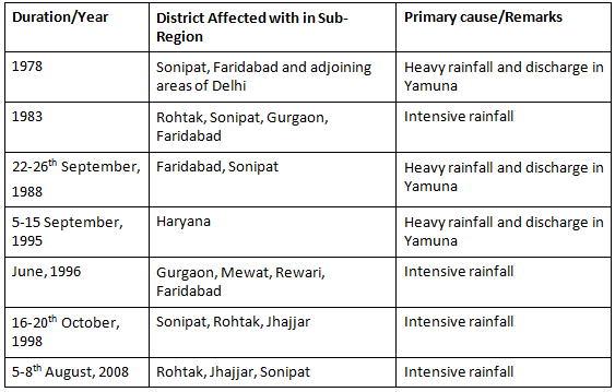
The flood history of the Haryana sub-region spanning from 1978 to 2010 reveals that episodes of heavy rainfall consistently lead to flooding in the districts of Rohtak, Sonipat, Gurgaon, and Faridabad. Sonipat and Faridabad, situated along the Yamuna River, experience flooding influenced by the rainfall in the river's catchment area, which includes the Himalayas. In contrast, the districts of Rohtak and Gurgaon primarily face flooding due to inadequate surface drainage facilities, necessitating re-sectioning to facilitate the efficient flow of floodwater. While reinforcing flood embankments along the Yamuna River may be beneficial, such measures must align with the hydrology of the area to prevent rainfall from becoming trapped in the district.
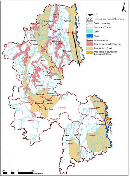 Flood Prone areas in the sub-region
Flood Situation
Among the significant disasters occurring in the sub-region, river-induced floods pose the most substantial threat due to their severe impact on agricultural crops. The origin of floods is linked to the distinctive rainfall patterns in the state. The geomorphic composition, featuring Himalayan topography in the north and the Aravali mountain range in the south, has given rise to a saucer-like topographic depression in the central part of the state. Floods primarily result from heavy runoff in mountainous terrain and overflow in the Yamuna River plains during the monsoon season. Active and historical floodplain areas in the sub-region are situated in parts of Panipat, Sonipat, and Faridabad.
Analysis of the Current Situation
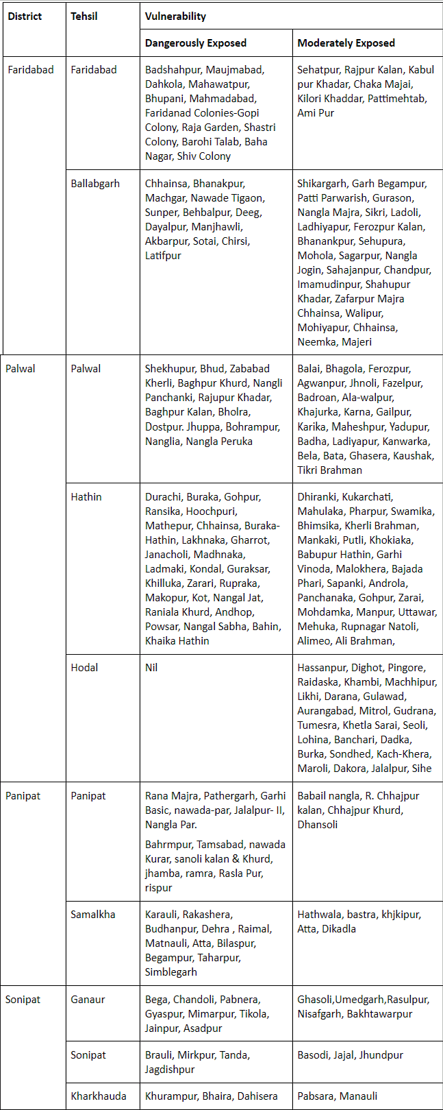
Prominent flood-prone areas with historical disaster experiences include Faridabad, Palwal, and Panipat districts, where the Yamuna River gauge levels have risen to 205-207 mm. Floods in these districts are predominantly caused by heavy rains and Yamuna River overflow. The hilly, valley-rich terrain in Faridabad and Palwal, coupled with overflowing local streams during rainfall, intensifies the flood impact. Excessive water discharge from the Tajewala head contributes to floods in the Yamuna River.
In contrast, heterogeneous topography is the primary cause of floods in other districts such as Gurgaon, Mewat, and Rohtak. Although there are no perennial rivers, numerous Barsati Nallahs/Hills Torrents traverse the entire region, causing floods during the rainy season. Low-lying areas in Rohtak, Jhajjar, and Rewari districts lead to waterlogging during heavy rainfall. Therefore, local-level strategies are essential for preparedness and response planning.
Given potential changes in rainfall patterns due to climate change, relying solely on past experiences may be insufficient for flood protection planning. Additionally, Rohtak and Gurgaon drainage is interconnected through Delhi, necessitating interstate collaboration. Considering these factors, a comprehensive flood management strategy involving Himachal Pradesh, Punjab, Haryana, and Delhi is imperative.
Conclusions
The following tables show the categories of the districts of the sub-region into two focus areas; major and minor.
Focus areas analysis

Villages vulnerable to flooding
|
95 videos|318 docs|111 tests
|
FAQs on Disaster Management - HPSC Preparation: All subjects - HPSC (Haryana)
| 1. What are the common types of hazards that can lead to disasters? |  |
| 2. What is disaster management and why is it important? |  |
| 3. How does the history of earthquakes in a region affect its vulnerability to future earthquakes? |  |
| 4. What is the role of flood management in reducing flood disasters? |  |
| 5. How does the flood situation impact disaster management in Haryana? |  |


